Finding common ground among fire scientists

A group of people knowledgeable about wildland fire have produced a 52-page document that attempts to assemble and summarize areas of agreement and disagreement regarding the management of forested areas in the western United States. Calling themselves the Fire Research Consensus Working Group, they looked for areas of common ground to provide insights for scientists and land managers with respect to recent controversies over the role of low-, moderate-, and high-severity fires.

Their report is titled, A Statement of Common Ground Regarding the Role of Wildfire in Forested Landscapes of the Western United States.

Here is how they hope their conclusions will be used:

Our hope is that stakeholder groups will avoid the selective use of particular scientific papers to argue for their particular ends. Instead, they will be able to point to key shared assumptions, common understandings considering the entire body of fire science literature, and terminology to support decision-making in constructive ways. In particular, land and fire managers are a key audience for this report, as are other stakeholders and the interested public engaged in discussions about land management.

The “Executive Summary” is 6 pages long. Below is the section about high-severity fire:


“Respondents disagreed about whether large, high-severity fires have increased to a significant and measurable degree in all forest types in comparison to historical fire regimes (i.e., prior to modern fire suppression). There was strong agreement that in dry pine forests at low elevations there has been either an observed increase in high-severity fires or an increase in the potential for fires of elevated severity as the result of increased abundance and connectivity of woody fuels since the late 19th century. There was similar strong agreement about dry mixed-conifer forests in the Inland Northwest, Pacific Southwest, and Inland Southwest (Arizona and New Mexico) that there has been an increase in high-severity fires and an increase in the potential for fires of elevated severity. There was less agreement about the changes in extent, and causes of changes in extent, of high-severity fires in moist mixed-conifer forests. Although there is general agreement that high-severity fires historically played an important role in moist mixed-conifer and cold subalpine forests, there is strong disagreement over the degree of changes in burn severity patch-size distributions and associated successional conditions for these forests between different regions.

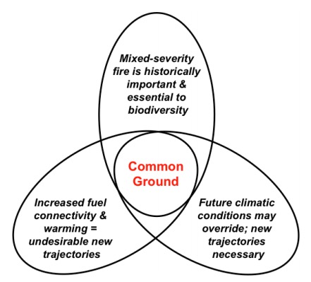
“Opinions also vary over the consequences of any increases in fire severity. For most dry forests, although there may be some disagreement about trends in burn severity and their causes, there is broad agreement that under current and projected climate, post-fire forest resilience is less than in the past. Some forest habitats, particularly at drier sites, but also in some moist and cold forest sites, show evidence of converting to more flammable non-forest vegetation or less dense forests following recent fires where large patches burn severely, especially if reburned. Reburn potential may depend on the interaction of vegetation, weather, rate of fire spread, time since prior fire, ignitions and fire suppression. Opinions are varied concerning the ecological consequences of departures from historical patterns of fire severity in various mixed conifer and subalpine forests. For example, one viewpoint supports the historical precedence of mixed-severity fire (including relatively large patches of high-severity fire), and the concept that pyrodiversity begets biodiversity. Another viewpoint asserts that increased woody fuel connectivity in combination with a warming climate trend is setting large areas of landscapes on fundamentally new trajectories, with significant undesirable ecological and societal consequences. Still a third viewpoint emphasizes that climatic changes increasingly are of overriding importance, and that new trajectories are unavoidable and thus may be considered desirable in many cases to incrementally foster necessary ecosystem transitions. The figure below characterizes these divergent viewpoints – typical of many areas of disagreement we addressed – and the potential common ground among them.

common ground wildland fire scientists

“Uncertainties associated with relative proportions of different burn severities and patch-size distributions combine to cloud key points of consensus that have important management implications. We suggest that resolving many fire science disagreements depends on greater consideration of specific geographical context. This may imply that a narrow range of field experience can limit one’s ability to accept findings that depart from that range. A logical way forward is to increase in-depth cross-regional field research experiences of the fire research community. Cross-regional comparisons of top-down and bottom-up determinants of fire activity in similar forest cover types is a fertile area of future research to examine how differences in seasonality, productivity, understory fuels, land use history, and other factors may explain some of the reported geographical differences in historical fire regimes in broadly similar forest types.

“There are several reasons for the disagreements about the amount and roles of past higher-severity fire. Both scientists and managers often transfer concepts and findings from one place to another, yet we know that “no one size fits all” for historical fire regimes, even within the same forest type. Likewise, the extent of change in abundance and connectivity of woody fuels varies across forest types and ecoregions. Some of the disagreement derives from use of different scientific approaches. For instance, there is strong debate about the fire regime inferences made from historical and modern tree inventory data, simulation models, and other approaches. We believe that application of diverse research approaches will be useful going forward. Further, multiple approaches will be useful in “triangulating” interpretations for which there is some scientific consensus (see Topic H). We challenge fire scientists who do not share similar perspectives on historical fire regimes in particular ecosystems to engage in civil discourse to better understand the reasons for their disagreement, and to objectively communicate those reasons to managers and other stakeholders. We are heartened by the positive outcomes achieved by some previous attempts when small or large groups work together to find common ground.”


Moritz, M.A., C. Topik, C.D. Allen, P.F. Hessburg, P. Morgan, D.C. Odion, T.T. Veblen, and I.M. McCullough. 2018. A Statement of Common Ground Regarding the Role of Wildfire in Forested Landscapes of the Western United States. Fire Research Consensus Working Group Final Report.

Thanks and a tip of the hat go out to Ben.
Typos or errors, report them HERE.

Helicopter crash, with injuries, starts fire, and rescuers are burned over

In addition to the personnel injured in the helicopter crash, two rescuers became victims

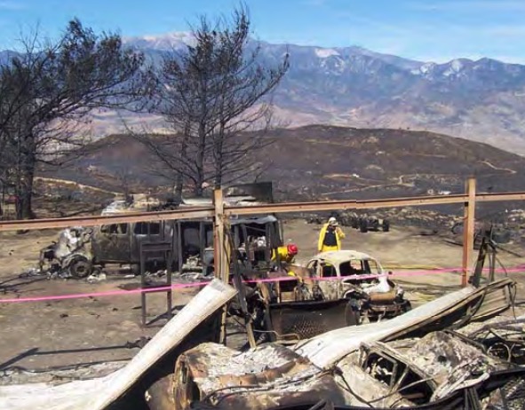
helicopter crash site
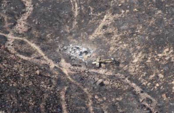
An overview of the crash site and the extraction point for the three victims. Photo from the report.

A report has been released for a helicopter crash in a very remote area of Nevada that started a fire, injured two passengers, and resulted in rescuers being burned over. It happened August 18, 2018 about 10 miles north of Battle Mountain.

One of the passengers called 911 on a cell phone at 1357:

We just got into a helicopter crash…three occupants, all of us are alive and managed to get out…started a big fire, fire is burning all around us right now…one of the guys hit his head pretty hard…you’re gonna have to get a helicopter, it’s the only way to get in here.

Adding to the complexity was the fact that several different agencies and organizations had various responsibilities: Lander County Dispatch, Battle Mountain Volunteer Fire Department, local EMS services, a medical helicopter, Elko Interagency Dispatch Center, and Central Nevada Interagency Dispatch Center.

As might be expected the complex communication chain between the victims and the actual emergency responders created some difficulties, including a delay in extracting the three personnel.

The Facilitated Learning Analysis does not speculate what caused the crash of the helicopter that was transporting two biologists on a chukar survey, but it started a fire, which was named Sheep Creek. The biologists and the pilot self-extracted, one of them with what appeared to be a serious head injury, and they all hiked up a steep slope to a flat bench where they awaited a helicopter. About two hours after the 911 call the three were evacuated from the scene by a firefighting helicopter that was on scene, and possibly also a medical helicopter. The report is not clear about this.

helicopter crash site
A closer view of the crash site. Photo from the report.

Meanwhile a volunteer fire department Type 4 engine that had responded in a search and rescue mode toward the crash site found that the condition of the road they were traveling on deteriorated from a 2-track road to a 4×4 trail, and finally ended. At that point the fire was closing in on their location. The rookie firefighter and the Fire Chief got out, and leaving their wildland fire personal protective gear in the truck, began to spray water around the vehicle.

From the report:

Within seconds, the fire was all around Pumper- 2. Both individuals were caught outside of the vehicle while trying to spray water. Neither had on their personal protective equipment (PPE) when the burnover occurred. The Chief stated, “We were in a rescue mission, so we had no PPE on.”

During the burnover, the firefighter jumped off the back of Pumper-2, started to run around the vehicle and then took refuge under Pumper-2. “I was burning and screaming and hunkered down underneath behind the rear tires.” After the burnover, the Chief yelled for the firefighter, whom he could not see anywhere. He eventually located the firefighter under Pumper-2.

After sustaining significant burns, both the Chief and firefighter got back into the vehicle, with the Chief driving, continuing down drainage. The fire was behind them as they continued driving through the black towards the bottom of the drainage. Pumper-2 drove through the bottom of the drainage over the rough terrain until getting stuck. Both individuals got out of the vehicle and proceeded to hike up the steep ridge until they got on top of the ridge to establish communications.

At 1646, Lander County Dispatch received a 911 call from the firefighter, who said he and the Chief had been burned. “We need help.” Dispatch was asking questions to establish a location, but the cell phone was breaking up. The firefighter said, “We might need a helicopter because we are on the ridge…in the black…wearing a red shirt and just uphill right of the engine.”

Suppression resources were actively engaged on the wildland fire during the burnover of the Pumper-2. The Incident Commander of the wildland fire was unaware that Pumper-2 was on the fire until well after the burnover occurred. The dispatch centers did not know the location of Pumper-2.

At 1745 the injured firefighters were located and extracted by the air medical and suppression helicopters to awaiting ground medical resources at Battle Mountain Airport. At about 1900, fixed-wing aircraft flew the injured firefighters to the University of Utah Burn Center in Salt Lake City, Utah.

The FLA points out a number of organizational and human issues that are worthy of consideration. One topic that was not thoroughly addressed in the report was the dispatchers and firefighting personnel at times did not know the exact location of the crash site or the victims, and were not aware that the engine was responding or it’s location following the injuries to the two firefighters.

Even when, eventually, the location of emergency responders will be able to be tracked on an incident, biologists and volunteer firefighters will probably be some of the last personnel to employ this capability on a routine basis.

Researchers look at how warming will exacerbate the occurrence of wildfires in Mediterranean Europe

wildfire portugal
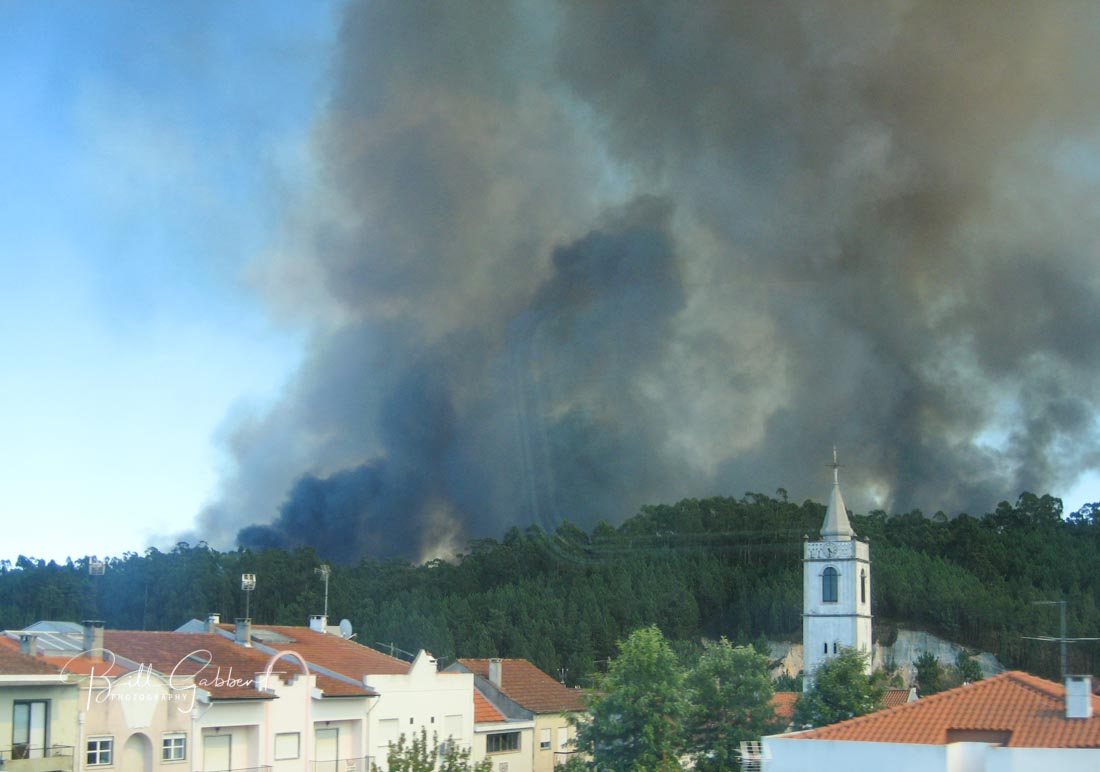
Wildfire south of Porto, Portugal, September 2, 2012. Photo by Bill Gabbert.

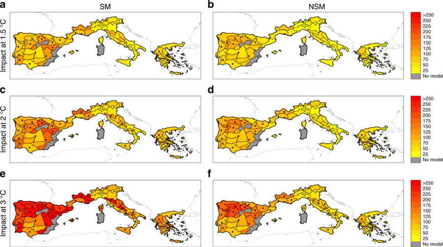
The climate warming that we have been seeing is expected to continue along with the increased risk of larger, more suppression-resistant wildfires. Scientists have examined how this will affect fires in Europe up to a 1.5°C  rise, which is the not-to-exceed target in the Paris climate agreement. Now a study is complete that examines increases of 1.5, 2, and 3°C warming scenarios. Not surprisingly, it found that the higher the warming level, the larger is the increase of burned area, ranging from ~40% to ~100% across the scenarios. Their results indicate that significant benefits would be obtained if warming were limited to well below 2 °C.

wildfires Climate Change Southern Europe
Ensemble mean burned area changes. Burned area changes (%) for a the +1.5 °C case with the stationary model SM (i.e., using Eq. 3), (b) the +1.5 °C case with non-stationary model NSM (i.e., NSM). using Eq. (4), (c) the +2 °C case with SM, (d) the +2 °C case with NSM, (e) the +3 °C case with SM, and f the +3 °C case with NSM. Dots indicate areas where at least 50% of the simulations (1000 bootstrap replications × the ensemble of RCMs) show a statistically significant change and more than 66% agree on the direction of the change. Coloured areas (without dots) indicate that changes are small compared to natural variations, and white regions (if any) indicate that no agreement between the simulations is found. Click to enlarge.

The paper, published in Nature, was written by Marco Turco, Juan José Rosa-Cánovas, Joaquín Bedia, Sonia Jerez, Juan Pedro Montávez, Maria Carmen Llasat, and Antonello Provenzale.

How Wildfires Are Polluting Rivers and Threatening Water Supplies

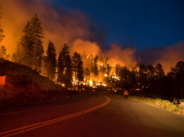
Little Bear Fire
Road 532 on the Little Bear Fire in New Mexico, June 13, 2012. Photo by Kari Greer.

A study conducted at the Yale School of Forestry & Environmental Studies looked at the increasing effects that wildfires are having on water supplies. It is titled, How Wildfires Are Polluting Rivers and Threatening Water Supplies. Below is an excerpt.


As hotter and dryer conditions spawn an increasing number of wildfires in North America and around the world, one of the overlooked impacts of these worsening conflagrations is on aquatic environments and drinking water supplies. Just as wildfires can have a regenerative effect on woodlands, so, too, can fires provide some benefits to streams and rivers in burned areas. But scientists are warning that intense and repeated fires can damage the ecology of waterways by exposing them to the sun’s heat, exacerbating flooding and erosion along denuded hillsides, and releasing toxins such as mercury that are often liberated from soil and tree trunks.

The effect of major wildfires on drinking water supplies can also be severe, as evidenced by fires that burned upstream of places such as Fort McMurray in Canada in 2016; Denver and Fort Collins, Colorado in 2002 and 2012; and Canberra, Australia in 2003. Water treatment plants in those places were overwhelmed by sedimentation, dissolved organic carbon, and chemicals that were released by fire.

With fires burning bigger, hotter, and more frequently, the threats to water supplies and aquatic systems are bound to escalate, according to Deborah Martin, a Colorado-based U.S. Geological Survey (USGS) scientist. She points out that an increasing number of regional, national, and global water assessments are now including wildfire in evaluating the risks to drinking water.

Legislation advances toward the Holy Grail of Wildland Firefighter Safety

esperanza fire fatalities
Five firefighters that worked on this engine were killed on the Esperanza Fire October 26, 2006 while protecting an unoccupied house. The firefighters did not know the location of the fire, and their Division Supervisor thought the crew was at a different, and safe, location.  A similar situation occurred on the Yarnell Hill Fire in 2013 where 19 firefighters were killed. The crew did not know the location of the fire and others assumed they were in a different, and safe, location. Photo from the official Esperanza Fire fatality report.

A Senate Bill introduced in January of this year took an important step through the legislative process Tuesday. The Wildfire Management Technology Advancement Act, Senate Bill 2290, was approved unanimously by the Senate Energy and Natural Resources Committee. It still has to be acted upon in the House of Representatives and the full Senate but this unanimous vote in committee is a good sign. It was introduced by Senator Maria Cantwell (D-WA) and co-sponsored by Cory Gardner (R-CO).

If the bill passes and is actually implemented by the federal land management agencies it would generate progress toward what we have called the Holy Grail of Wildland Firefighter Safety, knowing the real time location of a fire and the resources assigned. Too many firefighters have been killed when one or both of these critical pieces of situational awareness were unknown. Recent examples with a total of 24 line of duty deaths were on the Yarnell Hill and Experanza Fires.

The technology to monitor in real time a fire and firefighting resources has existed for years. Various systems are being used already by a few state and local agencies. The military does it for their war fighters, monitoring the enemy and their own forces. If implemented on fires, it will save lives. Firefighters lives are as important as soldiers.

The key points, below, in the legislation as currently written, have requirements for the Secretaries of Interior and Agriculture. The completion dates will be established from the time the legislation is signed.

  • Establish a research, development, and testing program, or expand an applicable existing program, to assess unmanned aircraft system technologies, including optionally piloted aircraft, across the full range of wildland fire management operations. (within 180 days)
  • Develop consistent protocols and plans for the use on wildland fires of unmanned aircraft system technologies, including for the development of real-time maps of the location of wildland fires. (within 1 year)
  • Develop and operate a tracking system to remotely locate the positions of fire resources, including, at a minimum, any fire resources assigned to Federal Type 1 wildland fire incident management teams. (within 1 year)
  • Establish a system to track and monitor decisions made by state and federal wildland firefighting agencies to flag unusual costs, and those that endanger firefighters or deviate from an applicable fire management plan. (no time requirement)
  • Assign air resource advisors to Type 1 incidents. (no time requirement)
  • Establish a system to collect data on firefighter injuries that were treated by a doctor, and all deaths during the Work Capacity Test, vehicle crashes, and aircraft accidents. (no time requirement)
  • The two Secretaries will work with NASA to establish a “Rapid Response Erosion Database” and maps that would make it possible to evaluate changes in land cover and soil properties caused by wildland fires. (no time requirement)
  • The two Secretaries, NASA, the Secretary of Energy, and the National Laboratories shall establish and maintain a system to predict the locations of future wildfires for fire-prone areas of the United States. (no time requirement)
  • Conduct a study to determine the feasibility of operating aircraft at night when managing wildland fires. (within 1 year)

A press release issued by Senator Cantwell’s office (below) gave a shout-out to Wildfire Today for our relentless pursuit of the Holy Grail. Here is the complete text:


Cantwell Bill to Modernize Firefighting Technology Passes Committee

Legislation would bring state-of-the-art technology, including real-time mapping and GPS locators, to firelines across the country

Washington, D.C. — Today, at a business meeting of the Senate Energy and Natural Resources Committee, U.S. Senator Maria Cantwell (D-WA) – the committee’s top Democrat –  secured passage of her bipartisan Wildfire Management Technology Advancement Act. The bill passed through committee unanimously.

The bill, co-sponsored by Senator Cory Gardner (R-CO), increases the use of technology to keep firefighters and communities safe, better reduce the risks from wildfires, and increase the effectiveness of wildfire response.

“We owe it to the brave men and women who risk their lives to fight wildfires to equip them with the best available technology, to keep them safe, and to ensure their efforts are effective,” said Senator Cantwell in her opening statement before the Senate Energy and Natural Resources Committee.

Included in the bill are measures to increase firefighter safety by providing crews on wildfires with GPS locators and using Unmanned Aircraft Systems to scout out and map wildfires in real-time. Wildfire Today refers to the simultaneous use of mapping aircraft and GPS locators as the ‘Holy Grail’ of firefighter safety. The bill also helps protect families and communities by assisting with smoke forecasting and planning for the impacts of smoke from wildfires.

Continue reading “Legislation advances toward the Holy Grail of Wildland Firefighter Safety”

Precipitation hits some areas in Western U.S.

(Originally published at 2:40 p.m. MDT October 3, 2018)

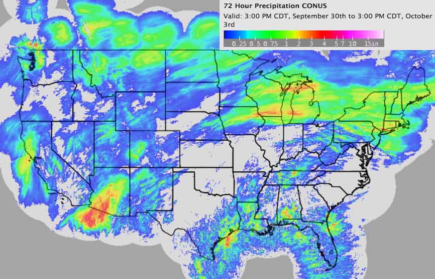
Precipitation last 72 hours
Precipitation 3 p.m. Sept. 30 to 3 p.m. Oct. 3. NWS. Click to enlarge.

(Originally published at 2:40 p.m. MDT October 3, 2018)

Quite a number of areas in the Western United States have received significant precipitation over the last 72 hours. The green, yellow, and red areas in the map above represent locations with more than one-third of an inch, which should impede the ignition or growth of wildfires.

The data in southern Arizona that shows two to four inches explains why rescues like the ones below were occurring in Phoenix.