Brian Head Fire spreads another 4 miles to northeast

The fire has now burned almost 50,000 acres.

(UPDATED at 8:37 p.m. MDT June 27, 2017)
(Originally published at 8 a.m. MDT June 27, 2017)
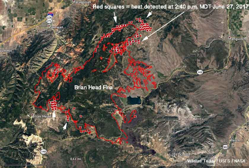
Map Brian Head Fire
Map of the Brian Head Fire. The red squares represent heat detected by a satellite at 2:40 p.m. MDT June 27, 2017. The red line was the perimeter at 12:11 a.m. MDT June 27, 2017. Click to enlarge.

****

Strong southwest winds gusting over 40 mph combined with relative humidity of five percent to push the Brian Head Fire in Utah another four miles to the northeast. Flames rising to 100 feet were reported by firefighters. The big run Monday afternoon added another 6,190 acres to bring the total burned area to 49,626. More fire activity south of Highway 143 resulted in another 200 acres burned east of the 050 Road.

The weather conditions on Tuesday will not be as severe as Monday, but could still result in significant additional spread of the fire while a Red Flag Warning in effect. The forecast for the fire area calls for 73 degrees, relative humidity of 9 percent, and southwest winds of 10 to 17 mph gusting up to 24.
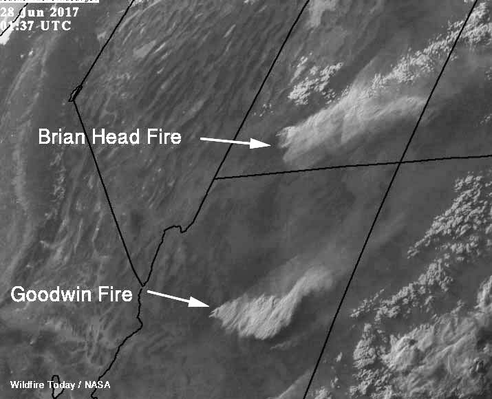
smoke Goodwinda and Brian Head Fires
At 7:37 p.m. MDT a satellite photographed smoke from the Goodwin and Brian Head Fires.

With that forecast in mind, firefighters are looking several miles north of the fire to where the fuels change from old-growth timber to sage and grass, which should result in more successful suppression efforts.

Evacuations are still in effect for many areas and Highway 143 is closed from the cemetery in Parowan to milepost 50 outside of Panguitch. Mammoth Creek Road is closed at the junction with Highway 143. The north side gate of 143/148 is closed. The Dixie National Forest has expanded its area closure to include Forest lands north of Highway 14.

Brian Head Fire was very active Monday afternoon

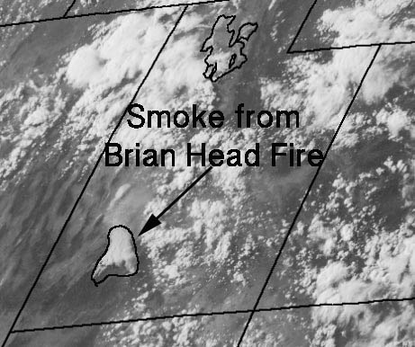
smoke Brian Head Fire satellite
A satellite captured a photo of smoke created by the Brian Head Fire in Utah at 5:45 p.m. MDT June 26.

The Brian Head Fire east of Cedar City, Utah was influenced by strong winds from the southwest that at times gusted over 40 mph while the relative humidity dipped to five percent.

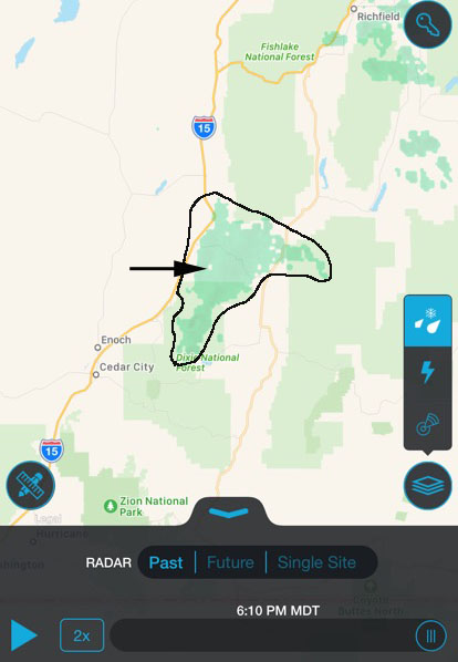
The intense burning caused a pyrocumulus cloud to develop as the fire and the smoke moved to the northeast. As you can see here, a satellite photographed the smoke plume and it was also detected by radar.

Only judging from the fire intensity shown in these images, I would be surprised if the indirect contingency firelines constructed Sunday by dozers northeast of the fire were able to constrain the blaze as hoped.

smoke radar Brian Head Fire
Radar detected smoke from the Brian Head Fire in Utah at 6:10 p.m. MDT June 26.

Forest Service Chief to report to new Acting Under Secretary

The new Secretary of Agriculture, Sonny Perdue, has selected a new Acting Under Secretary for National Resources and Environment, Dan Jiron. The U.S. Forest Service will be the only agency to report to Mr. Jiron.

He has a wealth of experience with the the U.S. Forest Service and other government organizations, including serving as the Information Officer for the South Canyon Fire Investigation Team in 1994.

In a message he recently distributed, Secretary Perdue described Mr. Jiron’s employment history:

“Dan Jiron will fill the role of Acting Deputy Under Secretary for Natural Resources and Environment.  With more than 29 years of public service and natural resources management, Jiron was appointed Associate Chief of the Forest Service in July 2016.

“Prior to this appointment, Jiron served in many leadership positions, including Regional  Forester of the Rocky Mountain Region; Deputy Regional Forester in the Pacific Southwest Region; Forest Supervisor of the Santa Fe National Forest; District Ranger on the Salt Lake Ranger District of the Uinta-Wasatch-Cache National Forest; District Ranger on the South Park Ranger District of the Pike and San Isabel National Forest, Comanche, and Cimarron National Grasslands; Director of Communications and Legislative Affairs of the Intermountain Region, National Press Officer in Washington, D.C.; and aide to United States Senator Ben Nighthorse Campbell of Colorado.

“Jiron earned a bachelor’s degree from Colorado State University and a Master’s degree from Regis University of Denver.”

Thanks and a tip of the hat go out to Dick.
Typos or errors, report them HERE.

TV news van catches fire near wildfire in Southern California

When a news van from NBC4 in Los Angeles caught fire yesterday while the crew was covering a wildfire in Placerita Canyon, it seemed likely that the two events were related, but “it appears” they were not, according to the TV station.

Firefighters describe the current wildfire conditions in the Southwest

Posted on Categories UncategorizedTags

In this very interesting video posted on June 22, 2017 several firefighters in the southwest part of Utah (where the Brian Head Fire is burning) talk about the current weather and vegetation conditions and how they deal with the extreme heat as they battle wildfires in the Southwest United States. It was produced by Community Education Channel, which “provides students of Dixie State University hands on learning experiences while producing quality Television and LIVE stream community content”.

Brian Head Fire slowed Sunday, but strong winds predicted for Monday

The spread of the Brian Head Fire east of Cedar City, Utah slowed on Sunday adding only 636 acres which was much less than in recent days. It has now burned a total of 43,436 acres.

The fire was still advancing Sunday on the north and south sides. The east flank has moved into lighter fuels (vegetation) which offers less resistance to control than heavier fuels found on the north and south sides. The west flank in the Brian Head area has been fairly stable for a couple of days except for an area northeast of town inside the Dixie National Forest.

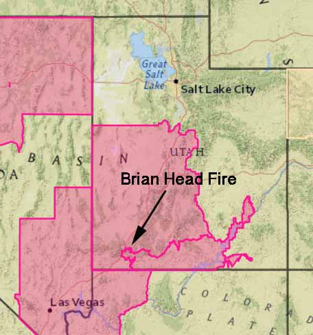
red flag warning utah wildfire
Red Flag Warnings are in effect Monday for areas in Utah and five other states.

The weather will change on Monday, with Red Flag Warnings in effect for southwest winds gusting up to 39 mph in the afternoon while the relative humidity bottoms out at 12 percent. This could challenge firefighters on the north side and test the contingency lines constructed in that area on Sunday.

Evacuations are still in place for many areas. Highway 143 is closed from the cemetery in Parowan to milepost 50 outside of Panguitch. Mammoth Creek Road is closed at the junction with Highway 143.

The crew in the photo below is from Colorado and usually consists of only five people.