Wildfire potential, April through July

Posted on Categories UncategorizedTags ,

wildfire potentialOn April 1 the Predictive Services section at the National Interagency Fire Center issued their Wildland Fire Potential Outlook for April through July. The data represents the cumulative forecasts of the ten Geographic Area Predictive Services Units and the National Predictive Services Unit.

Below are the highlights of their report. Following that are NIFC’s graphical outlooks for May through July and NOAA’s temperature and precipitation forecasts.

We also have the NOAA/USDA Drought Monitor which, in the history of our monthly reports, shows no extreme or exceptional drought in California for the first time in years.

****

“Florida and portions of Georgia, South Carolina, Texas and New Mexico continue to experience significant fire activity as warmer and drier-than-normal conditions persist. These conditions will persist as the fire activity peaks across the Southern Plains by May and across Florida through coastal Carolina by early June. Periodic, event-driven pre-green up grassfire activity continues across the central and northern plains and in the lower elevations of the West. This is normal activity and will continue to occur until full green up takes hold. Developing drought conditions across Central Texas and Oklahoma could elevate fire potential in May.

Western New Mexico and Arizona will begin to see an increase in significant fire activity in May before the monsoon begins to develop in late June and begins to curtail activity. As the fire season progresses into June and July, there are concerns with the seasonal shift west into California and north into the central Rockies and Great Basin. Exceptional winter and early spring precipitation will lead to the development of a substantial crop of fine fuels in the lower and middle elevations.

The heavy loading of fine fuels could become problematic when they cure out by July. In the higher elevations, the mountain snowpack is expected to melt at a normal to slower than normal rate due to the abundance of high elevation snow and the occurrence of an overall cool and wet spring. This could produce a delay in the onset of significant fire activity in the high elevations.

In Alaska, the south central portion of the state continues to be abnormally dry which has resulted in a winter snowpack that is below normal.

By mid-late July, the western fire season will begin to progress north into the Pacific Northwest and Northern Rockies. While a normal transition into fire season is expected in the lower elevations, a delayed entrance is possible in the higher elevations.”

****

wildfire potential

wildfire potential

Continue reading “Wildfire potential, April through July”

Information released about entrapment on 2016 Canyon Fire

Dozens of firefighters were entrapped and endured a harrowing escape through very thick smoke and flying embers.

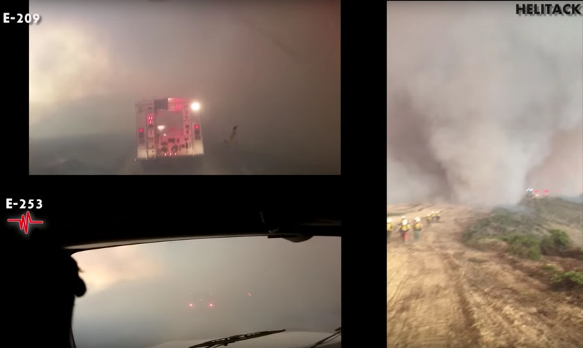
Above: an image from the official report, showing the conditions as firefighters were making their way to the safety zone.

The Wildland Fire Lessons Learned Center has released a review of the entrapment of dozens of firefighters that occurred six months ago on the Canyon Fire at Vandenberg Air Force Base.

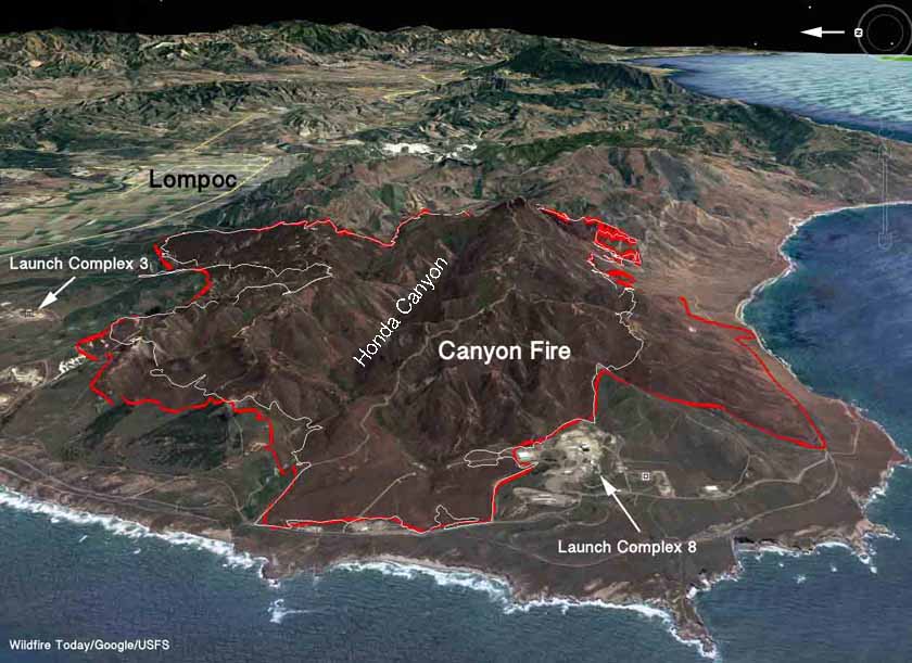
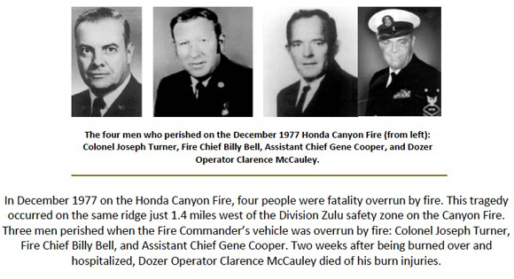
On September 19, 2016, two days after the fire started, approximately 50+ firefighters were assigned to Division Zulu on the north side of Honda Canyon (about a mile east of the site where four Air Force firefighters were entrapped and killed on the Honda Fire in 1977).

Assigned to the division on the Canyon that day in 2016 were 8 engines, 4 dozers, 1 water tender, and a 20-person hand crew comprised of 3 helitack crews. All were ordered by the Division Supervisor to take refuge in a safety zone.

Canyon Fire entrapment
3-D map of the Canyon Fire looking east. The red line was the perimeter of the Canyon Fire at 11 p.m. PDT September 20, 2016. The white line was the perimeter at approximately 11 p.m. September 19.

After observing conditions that morning last September the tactic decided on was to fire out the ridge on the north side of Honda Canyon, which runs east and west. The main fire was to the south on the other side of the canyon. The operation was going well until the intensity in the burnout increased dramatically; fire whirls developed and the fire began spreading to the west more quickly than the igniters and holders could keep up with it.

The Division Supervisor ordered, “All Division Zulu resources pull back to the safety zone”. Even though some of the personnel were about 600 to 700 yards from the safety zone, the smoke-obscured visibility occasionally made movement difficult or impossible. At times the engines had to stop when they could not see the ground in front of them. Burning embers, some of them fist-sized, pelted the vehicles and the 20 people in the hand crew that were walking to the safety zone.

In the video below, it appears to have taken about 10 minutes to travel the 600 to 700 yards. The recording shows how harrowing it must have been as day turned to night. At least two firefighters were later transported to a hospital suffering from smoke inhalation injuries.

The video is incredible and at times has on the screen views from three different cameras, apparently time-synced. Pretty impressive editing (by Mark Pieper and Tony Petrilli) for a government-produced video. The maps and annotated still images are also very useful.

Canyon Fire entrapment
A screenshot from the video, at minute 7:39.

Some firefighters, approximately two, removed their fire shelters from their gear. One was fully deployed and another was partially unfolded.

From the report:

When asked: “How scared were you on a scale of 1 to 10?” multiple crew members replied “9” and “10.”

We covered the Canyon Fire as it was burning and thought we were aware of the major developments at the incident, but we did not hear about this entrapment until today, March 27, 2017. Maybe we missed it, but it is possible that the fact that it occurred on a military base influenced an apparent desire to keep it low key, even though a California Type 2 Incident Management Team had assumed command of the fire the morning of the incident and, according to the report, “did start Regional notification regarding the shelter deployment”.

The Incident Commander and the Deputy IC were first notified more than three hours after the entrapment.

In spite of the late release of the information, firefighters can benefit from this lessons learned opportunity and the fact that the preparers of the report conducted it in such a way that there were apparently few if any efforts among those involved to “lawyer up” and shut up fearing litigation or prosecution. Many still and video images were made available and at least enough of the firefighters were willing to talk about what happened to allow a useful report to be completed.

Maybe the way this review was conducted can be a template to reverse the recent trend of investigations that are not as useful as they could be.

Honda Fire Fatalities 1977

On September 21, 2016 a Ventura County Fire Department firefighter was killed in a vehicle accident while responding to the Canyon Fire. Fire Engineer Ryan Osler, a passenger in a water tender, lost his life. The driver of the truck self-extracted and was transported to a local hospital with minor injuries.

Articles on Wildfire Today tagged “Canyon Fire”.

Five Corsica firefighters entrapped and injured

Above: Two of the fire engines that were entrapped on Corsica. The engine on the left appears to have small water nozzles on the bar that encircles the top of the cab.

During night firefighting operations on the island of Corsica overnight on March 24 and 25 three fire vehicles were entrapped by the fire resulting in five firefighters suffering first and second-degree burns. Some of the firefighters, it is not clear how many, took refuge in one or more of the fire engines that had vehicle protection systems consisting of water nozzles positioned around the truck that could be activated as needed.

Engine protection system

The fire occurred in the French commune of Bastelica in southern Corsica (map). Matthias Fekl, the Minister of the Interior, said Saturday morning:

In the early evening, a group of firefighters found themselves trapped in flames as a result of a change in wind direction. They then took refuge in their vehicles equipped with a self-protection device.

One person is in police custody, suspected of starting the fire.

Three firefighter vehicles were damaged or destroyed in the incident.

damaged fire engines

The fire engine in the above photo appears to be the same one in the photo (on the left) at the top of this article.

Wildland firefighters in Australia have also been using similar engine protection systems for years.

Fire along the water

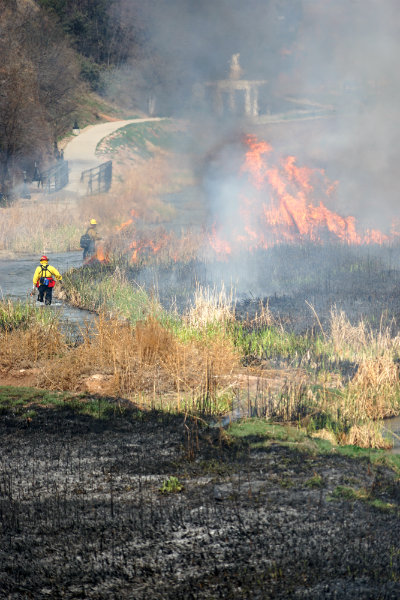
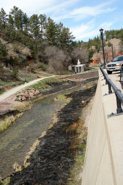
Every one or two years firefighters in Hot Springs, South Dakota treat a portion of the banks along the Fall River with prescribed fire. This reduces the woody vegetation that could otherwise build up to the point where it would impede the flow of water during a flooding event.

These photos were taken today by Bill Gabbert.

Previous times we have covered this project along the river.

Fall River prescribed fire

Fall River prescribed fire

Fall River prescribed fire

Learning from the past to fight future wildfires

The Spring edition of Fire Chief magazine is devoted to the
history, current trends and future of the wildland/urban interface fire threat. An article on pages 14 through 17 by Sarah Calams is titled, “Learn from past wildfires to fight future blazes: Understanding the scope and costs of historic and recent wildfires is necessary to plan for future fire suppression efforts”.

Below is an excerpt from the article, reprinted with their permission:

****

Fire Chief Article“…In the relatively modern-day United States, the first wildfire was recorded by Lewis and Clark in North Dakota in 1804. A prairie was set on fire and resulted in two deaths and three injuries.

In 1845, 1.5 million acres burned during the Great Fire in Oregon. In 1871, the worst recorded forest fire in North American history occurred in Wisconsin. The Peshtigo Fire burned over 1.2 million acres and killed an estimated 2,200 people. Coincidentally, the Great Chicago Fire occurred on the same day.

Fast-forward to the present and consider the number of major wildfires in the past decade. One of the largest fires in Oregon’s history occurred in 2012, and 19 firefighters were killed during the Yarnell Hill Fire in 2013. The Rim Fire, one of the largest fires in California’s history, also happened in 2013.

While the number of acres destroyed has increased over the decades, the number of fires has decreased. Nonetheless, U.S. firefighting suppression costs are expected to rise.

In 1990, those suppression costs were almost $400 million, while in 2000 costs were a little under $1.5 billion. Likewise, in 2016 costs reached almost $2 billion, according to the National Interagency Fire Center.

More than 10 million acres were scorched in 2015, while a little over 4 million acres were destroyed in 1990. As more acres burn and more human building reaches deeper into forested areas, the WUI threat rises.

Environmental factors

Bill Gabbert, who worked as a wildland firefighter in Southern California for 20 years and currently owns and manages WildfireToday.com, said one reason for the growth of wildfires is due to the more frequent occurrences of extreme weather.

According to Gabbert, extreme weather conditions, including drought and higher temperatures, can result in lower moisture content in vegetation. “Firefighters call this ‘fuel moisture,’” he said. “The less moisture there is in the live and dead fuel, the easier it is for fires to ignite and spread.”

That ignition, according to the National Park Service, is almost always caused by humans. The agency says that humans have a hand in starting 90 percent of wildland fires in the United States.

Human-caused fires can result from campfires left unattended, negligently discarded cigarettes and acts of arson, the NPS reports.

As a result, Gabbert said he’s skeptical of just naming weather as the main responsible factor in the number of fires and acres burned over the years.

“It is very difficult to say that one factor caused fire occurrence to change,” he said.

Other factors to consider, Gabbert said, include the capacity to suppress wildfires, the fact that more people are living and reconstructing in the wildland/urban interface, changes in vegetation and how timber is managed, fuel treatments, and changes in wildfire management policy…”

Man burning books ignites 696 acres and 2 homes

Above: The Garfield Road Fire in Florida, March 23, 2017. Florida Forest Service photo.

A Nassau County, Florida man intended to burn paperback books but the fire in his backyard escaped and blackened 696 acres and destroyed 2 homes. Approximately 19 outbuildings and 6 homes were damaged in the community 20 miles west of Jacksonville.

Annaleasa Winter of the Florida Forest Service said it was an illegal burn, and that it’s against the law to burn trash in Florida.