Multiple reports released about New Mexico megafires

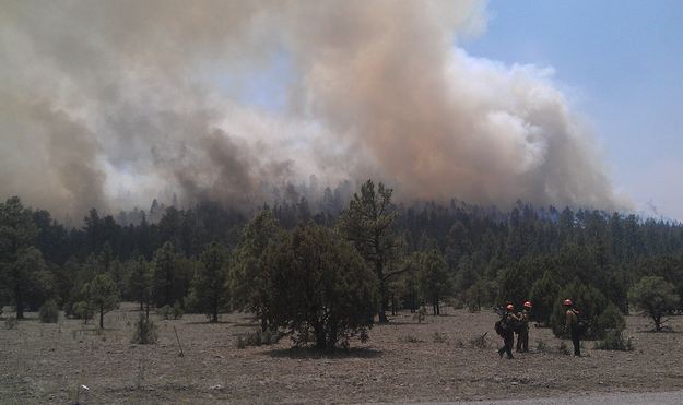
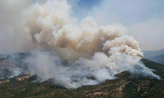
Whitewater-Baldy June 2, 2012 Photo by Kari Greer-USFS
Whitewater-Baldy fire, June 2, 2012. Photo by Kari Greer/USFS

U.S. Representative Steve Pearce has assembled five reports about two huge wildfires, megafires, that burned hundreds of thousands of acres and destroyed many homes in New Mexico in 2012. The Whitewater Baldy Complex blackened over 297,000 acres and destroyed 12 summer homes, while the Little Bear Fire burned 44,000 acres and 254 structures.
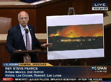
Rep Steve Pearce House of Representatives speech, western wildfiresIn June, 2012, Representative Pearce was extremely critical of the way the U.S. Forest Service was managing the fires, mentioning the name of Tom Tidwell, Chief of the Forest Service, many times during a 22-minute speech on the floor of the House of Representatives.

The five reports, plus one bonus article from the 1940s, can be found on Representative Pearce’s web site, and include the following:

  • William A. Derr, retired as Special Agent in Charge of the Law Enforcement and Investigative program in California. Mr. Derr was asked by Rep. Pearce to evaluate the management of the two fires, and was given the title of Legislative Fellow during his fact finding mission. It was an unpaid assignment, and Mr. Derr told Wildfire Today that he is not even sure if he will ask to be reimbursed for his travel expenses. 
  • Roger Seewald, retired from the U.S. Forest Service, began his career in wildland fire on the El Cariso Hot Shots in California, and after a decade or two switched over to law enforcement. At one point late in his career he worked out of the Washington office as Deputy Director, Law Enforcement and Investigations. In his report he stated he was representing the U.S. Forest Service. In Mr. Derr’s report he was described as “representing the Chief of the Forest Service”.
  • Doug Boykin, Socorro District Forester, New Mexico – Energy, Minerals and Natural Resources Department, Socorro District. Mr. Boykin was the Type 3 Incident Commander during one of the early stages of the Whitewater Baldy Complex. He wrote a 17-page report packed with details and photographs. One of those details that is surprising for an objective report by a government employee about a disastrous wildfire, is that he apparently thinks God controlled the fire, and wrote: “But, given what we know now, I feel this was the perfect set up by a higher power that had grown tired of our inability to use common since [sic] in forest management and chose to set things right in his own way.”
  •  Allen Campbell, a local resident and rancher who spent his early years “guiding clients”. His report covers the legacy and the environmental impacts of the fire, and is critical of the USFS fire management policy.
  • Impact DataSource, is an economic consulting, research, and analysis firm working out of Austin, Texas. Their report is titled “The Full Cost of New Mexico Wildfires”. The purpose of the report was to “…estimate the full impact of wildfires in New Mexico both during and after the wildfire occurs.” And, “…additional environmental,societal, economic and fiscal impacts are typically not tracked by any federal, state or local government or organization making the full impact of wildfires difficult to quantify.”
  • Earl W. Loveridge, formerly the Assistant Chief of the USFS, and before that the Assistant Chief of it’s Division of Operation and Fire Control. This reprint of a Journal of Forestry article appears to have been written in the mid-1940s. Chief Loveridge covered fire management policy, was critical of a “let burn” strategy, and pointed out the “importance of speed of control”. He also covered the 1935 origin of the “10 a.m. policy”, in which “Forester” F. A. Silcox stated, in part:
    •  “The approved protection policy on the National Forests calls for fast, energetic and thorough suppression of all fires in all locations, during possibly dangerous fire weather. When immediate control is not thus attained, the policy then calls for promptly calculating of the problems of the existing situation and probabilities of spread, and organizing to control every such fire within the first work period. Failing in this effort the attack each succeeding day will be planned and executed with the aim, without reservation, of obtaining control before ten o’clock of the next morning…. No fixed rule can be given to meet every situation; the spirit implied in the policy itself will determine the action to be taken in doubtful situations.”

The management of both fires, the Whitewater Baldy and the Little Bear, has been criticized. The Whitewater Baldy began as two fires, the Whitewater and the Baldy fires, which burned together. The Baldy was a “modified suppression” fire and was monitored, but the Whitewater was managed under a suppression strategy.

Much of the criticism of the Little Bear fire, including from Wildfire Today, was focused on what appeared from a distance to be less than aggressive suppression tactics, even though it was a suppression fire. Two firefighters worked the fire on the first day, and from day two through day five, while the fire was only four acres, a hotshot crew was assigned, but they had very, very little aerial firefighting support; limited use of one helicopter and no air tankers. On the fifth day the wind increased, a tree in the interior of the fire torched, and spot fires took off. The fire grew from 4 acres to 44,000 acres and destroyed 254 structures.

Mr. Derr’s report does not dig into the tactics of the fires, but concentrates primarily on the fire management policy of the USFS. He is critical of less than aggressive strategies, and regrets the abandonment of the 10 a.m. policy.

Mr. Seewald visited the four-acre site that comprised the Little Bear Fire for the first 5 days and cited steep slopes, heavy downed fuel, tree canopy, and rolling rocks as issues that made aerial support inadvisable, and for any more than one crew of firefighters to work the fire. He concluded that the USFS “…made every reasonable effort to extinguish the Little Bear Fire and used acceptable methods and strategies to control the fire.” He found very little to criticize other than suggesting that the USFS could “revisit” the methods used for communicating with the public and cooperators.

Little Bear fire
Little Bear fire. Photo from Seewald report.

The Seewald report said the strong winds that caused the spot fires to take off were not predicted in the spot weather forecasts provided to the firefighters.

Doug Boykin, the Incident Commander on the Whitewater Baldy Fire, believes that the decisions about management of the Whitewater and the Baldy fires were appropriate, after taking into consideration the firefighting resources available, weather, fuels, and topography. Mr. Seewald, while he did not say so explicitly, seemed to agree with that assessment.

Time-lapse satellite images of Whitewater-Baldy fire

The video below shows time-lapse satellite images of the Whitewater-Baldy fire in New Mexico between May 20 and June 6 — which in itself is pretty cool, but this was done with an iPhone. Really?, you’re thinking? Yes, really. Kirk Klausmeyer made it after capturing MODIS satellite imagery on his cell phone.

The images were acquired with an app for the iPhone called The World Daily, which can capture satellite images of any place (as long as it is on the planet Earth). Mr. Klausmeyer told us that after collecting the images, he converted them to a video using the free Google program Picassa.

Video of the BAe-146 jet air tanker dropping on Whitewater-Baldy fire

Here is the description that the Southwest Area Type 1 Incident Management Team posted with the video on May 30, which is titled Tanker 40-Bae-146 Retardant Drop Whitewater-Baldy Fire:

Air Tanker puts down a line of fire retardant on Whitewater-Baldy Fire off of the 141 road. This drop was to help pretreat the north side of the road so fire crews could do their burn out on the south side of the road.

It’s not a great shot of the air tanker, but if you look carefully you can see two engines hanging below the right wing, which indicates that it IS the BAe-146 jet-powered Tanker 40.

I noticed that the lead plane was louder than the air tanker, which is very unusual — much less noisy than tankers with huge radial piston engines. BAe-146s are known for their relatively quiet operation, which enables the airliner to fly into some noise-restricted airports when others can’t.

Another thing I noticed was that the pilots were extremely accurate with their drop, placing the retardant right on the edge of the road, probably exactly where the firefighters wanted it.

Here is a bonus video from the Whitewater-Baldy fire, also posted by the Southwest Area Type 1 Incident Management Team. It was shot in the same general area, on the northeast side of the fire along Forest Road 141, May 28, 2012.

The Guardian writes about budget cuts and the Whitewater-Baldy fire

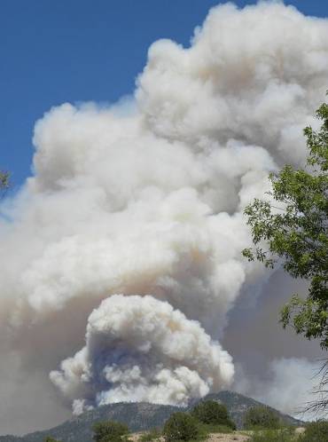
Whitewater-Baldy fire, May 28, 2012
Mt. Taylor Hot Shots burning out on the Whitewater-Baldy fire along Forest Road 141, May 28, 2012. USFS photo by Steven Meister, Mt. Taylor Hot Shots.

The Guardian is a newspaper based in the United Kingdom, but they also have a substantial presence in the United States. One of their Washington D.C. based reporters, Suzanne Goldenberg, published two articles today about wildfires in the U.S., and specifically the Whitewater-Baldy fire, which at over 216,000 acres has blasted through the record set last year by the Las Conchas fire for the largest in the recorded history of New Mexico. Ms. Goldenberg’s articles are well-researched and written, and are worth reading, in spite of one particular quote. She obviously talked with actual firefighters on the ground, as well as some folks that you will recognize that are sitting comfortably hundreds of miles away from the fire.

The first article concentrates on the declining budgets of the land management agencies that are involved with fire management. The second covers the Whitewater-Baldy fire, mega-fires, and stories from locals and firefighters, including the first firefighters to rappel into the fire.

Here is an excerpt from the beginning of the first article:

Fire experts are warning that $512m in congressional budget cuts could leave communities dangerously exposed in an early and active fire season.

Such warnings have sharpened with the early onset of this year’s fire season, and the record-setting outbreak in New Mexico.

Experts fear the shortfall will leave fire crews scrambling for resources, and force government agencies to dip into other non-fire budgets to cover the gap.

“A person has to wonder. Is this going to be the new norm – frequent record-setting fires, while the number of federal firefighters and air tankers continue to shrink?” wrote Bill Gabbert, a former fire management officer in the Black Hills of South Dakota who now runs the blog wildfiretoday.com.

A strategic review in 2009 warned the government to step up its fire fighting capabilities to deal with an escalating rise in wildfires, covering up to 12m acres of terrain each year. “The current budget environment for federal and partner fire management is at best uncertain and difficult,” the review said.

It noted government agencies had already over-shot their budgets five years in a row, because of escalating wildfires.

But the economic downturn and a Congress dominated by Republicans who want to shrink the role of government make it extremely complicated to divert more funds to forest fighting.

Instead, funding for preventing and putting out wildfires has fallen by $512m, or about 15%, since 2010.

Join Ms. Goldenberg from the Guardian and myself on June 4 when we co-host a live web chat about wildfires. More information can be found HERE.

Firefighters faced challenges during firing operations on Whitewater-Baldy fire

Whitewater-Baldy fire, 4 pm, May 29, Andrea Martinez, USFS
Whitewater-Baldy fire, east of Glenwood, NM, 4 pm, May 29. Photo by Andrea Martinez, USFS

Firefighters on the Whitewater-Baldy found themselves conducting firing operations (burnouts or backfires) with the relative humidity as low as two percent and wind gusts up to 26 mph on Tuesday. One of the firing operations on the 152,000-acre blaze was on the northeast side of the fire where firefighters battled extreme fire behavior with spot fires occurring up to one mile ahead of the fire. The Incident Management Team reported that the Probability of Ignition today was 100%. That is, according to weather conditions and fire behavior models, if a firebrand landed in receptive fuels (vegetation) there was a 100 percent probability that it would start a new fire. Firefighters who were directed to ignite burnouts or backfires under those conditions deserve a raise. There were multiple spot fires across Forest Road 141, with one of them growing to 20 acres, but remarkably they were all suppressed by firefighters, engines, a dozer, and two air tankers. Neptune’s Tanker 40, the BAe-146 jet, was one of the air tankers used on the fire today. A big pat on the back goes out to those folks who did great work under interesting conditions.

Other aircraft on the fire included twelve helicopters: three Type 1 (the largest helicopters), four Type 2, and five Type 3.

IR plane, N144Z
N144Z, USFS Infrared Aircraft

A U.S. Forest Service fixed wing infrared imaging airplane, N144Z, a Cessna Citation jet, has been mapping the fire during the night for the last several nights providing accurate information about the location of the fire perimeter and the extent and intensity of heat sources across the fire. The data is digitized and transmitted via radio from the aircraft immediately after it is collected and ends up in internet servers on the ground . Then an Infrared Analyst, who can be located anyplace where there is a computer with internet access and ESRI software, interprets the imagery and sends it to the Situation Unit on the fire. When everything works perfectly, they will receive it with enough lead time to produce maps that are used for the morning briefing and the Incident Action Plan.

Flight of N144Z, May 28-29

The map to the right shows the flight of N144Z  between 10:38 p.m. May 28, and 1:09 a.m. May 29. It departed from Phoenix, mapped the Gladiator and Whitewater-Baldy fires, then landed at Farmington, New Mexico for fuel. Then it mapped one or two fires in Colorado before heading for home at Ogden, Utah.

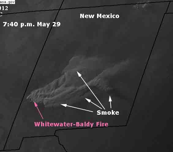
The satellite photo below, taken at 7:40 p.m. today, which we helpfully annotated for your viewing pleasure, shows the smoke that was generated by the extreme fire behavior on the Whitewater-Baldy fire today.

Smoke Whitewater-Baldy fire 740 pm MDT May 29, 2012
Smoke Whitewater-Baldy fire 7:40 p.m. MDT, May 29, 2012

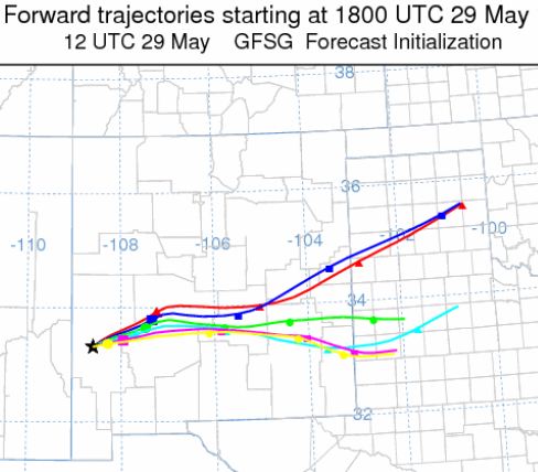
You can compare the actual trajectory of the smoke with the projections created by computer models below. Each line is a 24-hour period, beginning at noon local time. The tic-marks on the lines are six hours apart.

Smoke projection for Whitewater-Baldy fire, May 29, 2012

West wind blows Whitewater-Baldy fire smoke across NM toward TX

Smoke Whitewater-Baldy fire 740 pm MDT May 28, 2012

On Monday afternoon a 9 to 12 mph west wind, gusting up to 22 mph, blew the smoke created by the Whitewater-Baldy fire east across New Mexico, headed toward Texas. The satellite photo above was taken at 7:40 p.m. MDT, May 28.

Smoke map - 742 pm MDT, May 28, 2012

You can compare this with the models from Monday morning which predicted the direction the smoke would take. A higher resolution version of the map below can be found HERE.

Smoke projection for Whitewater-Baldy fire, May 28, 2012

Very low humidity and calmer winds affect Whitewater-Baldy fire In New Mexico

Whitewater-Baldy fire and an old fire scar, May 22. InciWeb photo

UPDATE at 8:32 p.m. MDT, May 28, 2012

We checked with Jerry Perry, a spokesperson for the Incident Management Team at the fire and received some updated information. Mr. Perry said burnout operations occurred in two locations on Monday, near the ghost town of Mogollon to help protect that community, and an area south of Mogollon where the spread of the fire dictated that a burnout needed to be executed in order to keep the fire from moving into unwanted areas.

The fire started on May 16 and the Type 1 Incident Management Team assumed command on May 26. The number of resources working on the fire has increased very slowly.

On Sunday there were five helicopters assigned, none of them Type 1 (the largest), according to Mr. Perry. On Monday there were nine helicopters: three Type 1, two Type 2, and three Type 3. These are small numbers of aircraft for a monster-sized fire. There were no air tankers working the 133,000-acre fire on Monday, because, according to Mr. Perry, “the terrain was not suitable for air tankers”.

The number of personnel assigned to the fire has increased to 1,112 and there are a total of 27 hand crews and 49 engines.

==================

Usually firefighters can count on “humidity recovery” during the night to slow the spread of wildfires. That higher humidity, usually increasing by several tens of percent, is absorbed by the vegetation and affects how fast a fire burns. Sunday night and early Monday morning, the relative humidity at the Mogollon weather station near the Whitewater-Baldy fire was between three and seven percent — extremely low. As the sun started to come up it began increasing and was at ten percent at 9:13 a.m. MDT; still very low.

Weather at Mogollon May 28, 2012
Weather at Mogollon, May 27 to 28, 2012

The forecast for Monday at Glenwood, NM just west of the Whitewater-Baldy fire calls for the humidity to decrease again to around five percent and the winds will be from the southwest at 7 to 14 mph. The calmer winds will make it possible for helicopters and air tankers to support the firefighters with retardant and water drops. But the very low humidity and moderate winds should still encourage significant fire spread and smoke production.

Whitewater-Baldy fire 1140 pm MDT May 27, 2012
Map of the Whitewater-Baldy fire in New Mexico, showing heat detected by satellites at 11:40 p.m. MDT May 27, 2012. The red and orange areas burned in the previous 24 hours.

On Sunday the fire grew by another 10,000 acres, bringing the total to about 133,000 acres. Firefighters took advantage of the calmer winds to do some burning out at the end of the long finger of fire on the northeast side, along Forest Road 141/Reserve Beaverhead Road near the Negrito Airstrip. If they can stop the fire in this area, it will be a step toward keeping the fire out of some more difficult terrain.

Almost all of the fire perimeter showed new growth on Sunday and officially the fire is zero percent contained. On Monday firefighters plan to conduct a burnout operation to help protect the ghost town of Mogollon, and will continue to burnout along Forest Road 141.

Below is something you don’t see produced by every Incident Management Team, a map showing the projected path of smoke from the Whitewater-Baldy Complex for May 28. Areas around Albuquerque, Belen, Socorro, Magdalena and Carrizozo will see smoke through the day, if the projections are correct. A higher resolution version of the map can be found HERE.

Smoke projection for Whitewater-Baldy fire, May 28, 2012

Whitewater-Baldy fire adds 40,000 acres; may exceed 360,000 acres

Whitewater-Baldy fire 307 am MDT May 27, 2012
Map of the Whitewater-Baldy fire, showing heat detected by satellites at 3:07 a.m. MDT May 27, 2012. The red and orange areas were the most recently burned.

The Whitewater-Baldy fire on Saturday, pushed by strong southwest winds gusting up to 37 mph, added another 40,000 acres and ran 12 miles beyond Highway 159 toward the northeast as far as Reserve-Beaverhead Road. The fire has now blackened a total of 122,000 acres, but that may pale in comparison to the ultimate size of this monster fire. The Incident Management Team has  planned a fireline which would triple its size to over 360,000 acres. The Team apparently concluded that this may be the only viable alternative. The fire continually outflanks the shorthanded firefighters, with the rapid rate of spread exceeding their capabilities to construct effective fireline.

Massive burnout operations from indirect firelines miles from the main fire are not unprecedented on major fires. In recent memory they have been used, mostly successfully, on fires on the Los Padres National Forest in southern California, including the Basin Complex, Indians, Iron Alps, and Zaca fires. Bill Molumby who was Incident Commander of a Type 1 Incident Management Team during phases of these fires, successfully directed (along with others) huge burnouts that ultimately stopped the spread of the fires after they had burned for weeks or months. But implementing large, risky plans like these require the best of the best — highly skilled and experienced Incident Commanders, Operations Section Chiefs, Division Supervisors, and firefighters on the ground. They can take weeks or months to complete, and we hope that the necessary personnel, equipment, and firefighters can be found that can safely execute such an ambitious plan. Maybe Bill Molumby, or someone else equally skilled, can be brought out of retirement to assist during the next several weeks or months.

And there is always the chance that the weather will change and mother nature will put out the fire.

Whitewater-Baldy fire, the 141 Road, 5-26-2012, NWS photo
Whitewater-Baldy fire. The 141 Road. May 26, 2012. NWS photo

So far the relatively small force of 586 personnel, 26 Engines, 2 Dozers, 4 helicopters, and 2 air tankers has been largely ineffective in suppressing the fire. As we noted on Saturday, the number of resources assigned to this 122,000-acre fire is much less than was on the 4,100-acre Banner fire earlier this week which had 73 engines, 2 dozers, 6 air tankers, 7 helicopters, 47 hand crews, and 965 personnel. Thanks to the aggressive initial attack and favorable weather, the Banner fire is expected to be fully contained on Monday. But the degree of difficulty facing the firefighters on the Whitewater-Banner fire is real, with rough country, and powerful winds.

Smoke from the fire is having a significant impact over much of the United States, as you can see from the map below. Some residents of Colorado are detecting a strong odor of smoke and are assuming that there is a nearby fire, but depending on their location, it is most likely coming from the Whitewater-Baldy fire in western New Mexico.

Dense and very visible smoke is drifting into the Albuquerque area, 150 miles northeast of the fire, as seen in this video.

Smoke map - 913 pm MDT, May 26, 2012
Smoke map - 9:13 p.m. MDT, May 26, 2012. NOAA

On Saturday the fire spread to within 2.6 miles of Mogollon, which is frequently described as a ghost town, but has structures listed on the National Register of Historic Places.

Whitewater-Baldy fire grows to 82,252 acres; 12 cabins burned

Whitewater-Baldy fire 0800 MDT May 25, 2012
Map of the Whitewater-Baldy fire, showing heat detected by satellites at 8:00 a.m. MDT May 25, 2012

The Whitewater-Baldy fire in southwest New Mexico grew on Thursday to 82,252 acres. The Incident Management Team announced that 12 cabins have burned as well as 13 outbuildings. Below is an update provided by the IMTeam on InciWeb:

====================================================

Friday, May 25, 2012 – AM Update: The Whitewater-Baldy Complex grew yesterday to a total of 82,252 acres. Fire behavior was not as extreme as was observed the previous two days. The complex continues to burn in steep, rugged terrain consisting of mixed conifer and continues to be primarily wind and terrain driven. The Whitewater Fire merged with the Baldy Fire on Wednesday, May 23, causing suppression and incident management forces to combine into Whitewater-Baldy Complex.

The fire is currently burning on 3 Ranger Districts, the Glenwood, Reserve and Wilderness Ranger Districts along with an area of private land known as Willow Creek Subdivision. Twelve cabins have been confirmed as lost in this subdivision along with 13 out-buildings. There were NO additional structures lost in the last 24 hours in the Willow Creek Subdivision. Personnel from New Mexico State Forestry and U.S. Forest made all necessary contacts with effected landowners yesterday. Structural protection and damage assessment continue in Willow Creek and structure protection assessments were also initiated in the village of Mogollon.

Due to extreme fire behavior, proximity to private land, and continued high winds forecasted, Tony Sciacca’s Southwest Type 1 Fire Management Team was ordered and arrived in Reserve yesterday. They will assume command of the complex on Saturday morning.

The complex remains at 0% containment as firefighters are unable to directly suppress the fire due to extreme fire behavior and rough terrain. They were, however, able to directly and successfully attack a few spot fires out ahead of the fire on the north end. Crews will continue their hard work today in preparing fire lines across and along the Mineral Creek drainage. Indirect fire line was constructed to the north from Bursum Road to Log Canyon trail connecting to a jeep trail.

Winds are predicted to continue to challenge fire fighters today and tomorrow, shifting from a southwesterly wind to more of a southern wind. Firefighters will be carefully monitoring winds as they continue their efforts. Smoke impacts continue to be substantial in communities to the east and northeast of the complex. A voluntary-evacuation of the town of Mogollon continues to be in effect. Approximately 506 personnel are currently assigned to the fire.

See the latest update on the Whitewater-Baldy fire, dated May 27, 2012.