The smoke will worsen Thursday afternoon and evening
Wildfire smoke forecast for 7 p.m. Oct. 14, 2021. NOAA.
Residents along the Southern California coast are seeing the effects of the Alisal Fire in the air they are breathing. On Thursday the South Coast Air Quality Management District issued a special air quality advisory for smoke that will be worsening during the afternoon.
Heavier concentrations of the smoke are expected to move into the counties of Orange, Riverside, San Bernardino, and L.A. Thursday afternoon and evening.
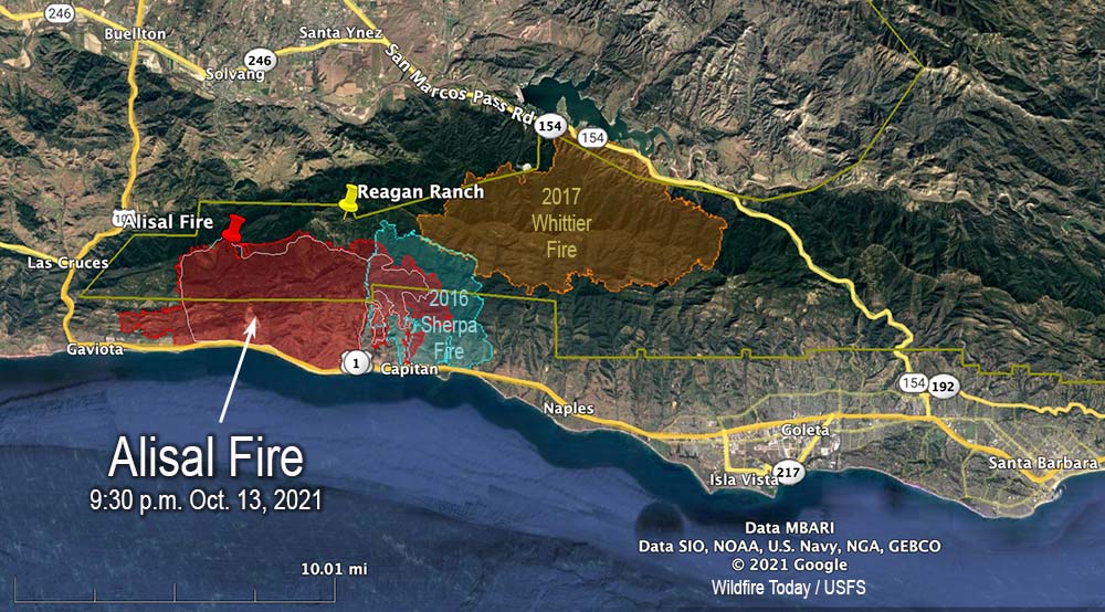
Alisal Fire vicinity map. The red line was the perimeter at 9:30 p.m. PDT Oct. 13, 2021. The white line was the perimeter about 24 hours earlier. Scroll down to see a more detailed map.
On Wednesday the Alisal Fire, 11 miles west of Goleta, California spread two miles further west and one mile to the east. On the east side it is still spreading through the five year old footprint of the Sherpa Fire.
Air tankers took advantage of decreasing winds Wednesday to apply retardant on the north side, reinforcing the West Camino Cielo road out to Gaviota on the west side. Crews conducted a firing operation along the road later in the afternoon.
Looking east at the Alisal Fire; retardant applied on the north side of the fire near West Camino Cielo road Oct. 13, 2021. Air Attack photo.
Additional evacuations were ordered Wednesday night for the area west of Arroyo Hondo to the intersection of Hwy. 101 and Hwy. 1, including Vista Del Mar School and Gaviota Beach. The ranch formerly owned by President Ronald Reagan, known as the Western White House, is also under evacuation orders. (More information about evacuations.)
To see all articles on Wildfire Today about the Alisal Fire, including the most recent, click HERE.
Thursday morning fire officials said the fire had burned 16,801 acres. Resources assigned to the fire Wednesday evening included 31 hand crews, 143 engines, and 8 helicopters for a total of 1,306 personnel, an increase of 541. Management of the fire has transitioned to a California Type 1 Incident Management team led by Jerry McGgowan.
Alisal Fire map. The red line was the perimeter at 9:30 p.m. PDT Oct. 13, 2021. The white line was the perimeter about 24 hours earlier. The red dots represent heat detected by a satellite at 1:48 a.m. PDT Oct. 14, 2021.
On Thursday firefighters are going to be faced with wind directions shifting about every six hours. Southwest winds are likely to develop in the morning, which may turn southeasterly in the early afternoon, before becoming northwesterly Wednesday evening. The relative humidity will be in the low 20s, but will rise to the mid-50s Wednesday night. Light and mostly onshore winds are in the forecast for Friday.
Alisal Fire, seen from Santa Ynez Peak, looking west-southwest at 7:04 a.m. PDT Oct. 14, 2021.Alisal Fire map, 3-D looking east. The red line was the perimeter at 9:30 p.m. PDT Oct. 13, 2021. The white line was the perimeter about 24 hours earlier.Alisal Fire map, 3-D looking west. The red line was the perimeter at 9:30 p.m. PDT Oct. 13, 2021. The white line was the perimeter about 24 hours earlier.
Below is a timelapse video of the Alisal Fire — about five hours compressed into 30 seconds. It was shot by the AlertWildfire camera on Santa Ynez Peak, looking west-southwest, from 2:20 p.m until 7 p.m., October 13, 2021.
Charred landscape at the Alisal Fire, off Refugio Road, Oct. 13, 2021
14,500 acres Wednesday morning, 12 miles west of Goleta, California
8:12 a.m. PDT Oct. 13, 2021
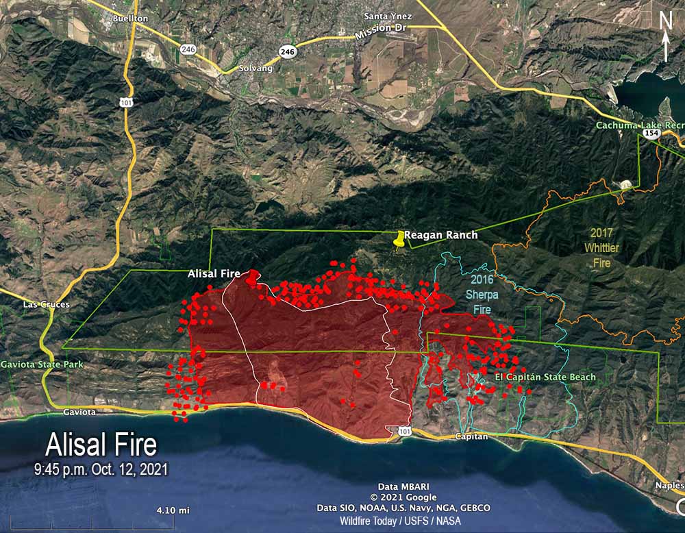
Alisal Fire map 9:45 p.m. Oct. 12, 2021. The red line was the perimeter at 9:45 p.m. PDT Oct. 12, 2021. The white line was the perimeter at 4:12 a.m. Oct. 12. The red dots represent heat detected by satellites at 2:56 a.m. PDT Oct. 13.
Wednesday morning the Santa Barbara County Fire Department said the Alisal Fire 12 miles northwest of Goleta, California has burned 14,500 acres, an increase of 1,100 acres over the figure released Tuesday evening. The growth over the last 24 hours has been on all sides, with the exception, of course, where the fire was stopped by the Pacific Ocean on the south.
The east side of the fire has burned into Sherpa Fire of 2016. During the 9:45 p.m. mapping flight Tuesday the strong winds and low fuel moisture helped it to spread two miles into the five-year-old footprint.
To see all articles on Wildfire Today about the Alisal Fire, including the most recent, click HERE.
Highway 101, the Pacific Railroad, and Amtrak lines remain closed and evacuations are still in effect. (More information about evacuations.)
On Wednesday fire officials expect to have working on the fire 5 air tankers, 6 helicopters, and a total of 1,300 personnel.
Alisal Fire map, 3-D, 9:45 p.m. Oct. 12, 2021. The red line was the perimeter at 9:45 p.m. PDT Oct. 12, 2021. The white line was the perimeter at 4:12 a.m. Oct. 12.
The spot weather forecast produced for the incident calls for 5-10 mph northeast winds Wednesday morning, becoming south to southwest at 5 to 10 mph by noon, then changing to come out of the northwest after 6 p.m. at 15 to 20 mph with gusts to 35. The humidity will be in the upper teens until it begins to rise in the afternoon. The standard NWS local forecast for the area is a little different.
Alisal Fire map, east side, 9:45 p.m. Oct. 12, 2021. The red line was the perimeter at 9:45 p.m. PDT Oct. 12, 2021. The white line was the perimeter at 4:12 a.m. Oct. 12. The red dots represent heat detected by satellites at 2:56 a.m. PDT Oct. 13.
Firefighters expect to have winds on Wednesday that will allow the use of fixed and rotor wing aircraft at least part of the day.
Firefighters on the Alisal Fire, Oct. 12, 2021. SBCFD photo.
7:09 p.m. PDT Oct. 12, 2021
Alisal Fire, seen from Santa Ynez Peak, looking southwest at 5:25 p.m. Oct. 12, 2021.
The wind slowed a bit late in the afternoon Tuesday, enough to allow fixed wing air tankers to work the Alisal Fire. At one point there were three over the fire and another four at the Santa Maria Airport 31 miles to the northwest. Helicopters have also been dropping water.
Most of the air tanker activity was on the west side, which corresponds with heat detected in that area by a satellite at 2:55 p.m. PDT. A weather station on Alisal Road recorded winds coming from the north-northwest, north, and north-northeast gusting around 20 mph hour between noon and 4:20 p.m. This could have caused more growth to the west.
The 2:55 p.m. satellite data showed significant growth on both the east and west sides Tuesday.
Fire officials said Tuesday evening the fire had burned 13,400 acres, almost double the last update.
KEYT reported that the Alisal Fire burned approximately 3,000 acres by 7:30 p.m.
7:02 p.m. PDT Oct. 11, 2021
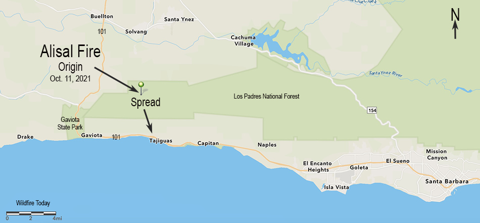
Map showing the origin location and initial spread of the Alisal Fire, October 11, 2021.
Within a few hours after it started at about 2:30 p.m. PDT Monday, very strong winds pushed the Alisal Fire three miles downhill from a ridgetop to the Pacific Ocean at Refugio State Beach west of Santa Barbara, California. Winds out of the north-northwest at 20 to 30 mph gusting to 50 drove it to Highway 101 by 5:30 p.m.
To see all articles on Wildfire Today about the Alisal Fire, including the most recent, click HERE.
Alisal Fire 3-D map, Oct. 11, 2021, looking north.
The wind was so strong that air tankers and even a mapping plane were unable to work on the fire during the initial hours.
Alisal Fire at Hwy. 101 at 5:43 p.m. Oct. 11, 2021. Via OurAirSBC
Monday afternoon the Alisal Fire was 25 miles west-northwest of Santa Barbara and 5 miles northeast of Gaviota.
Highway 101 is closed in the area and evacuations are in effect. An interactive evacuation map is available at https://arcg.is/1zO4m8. Enter your address at the top right field to determine if your area is under an Evacuation Order.
Alisal Fire, soon after it started. By Los Padres NF Air Attack. Oct. 11, 2021.
The relative humidity was surprisingly high Monday afternoon, ranging from 30 to 50 percent. The weather forecast for the fire area is for the wind to continue to be from the northwest until 10 p.m. Tuesday. The speed until 11 p.m. Monday is predicted to be 37 gusting to 49 mph, then decreasing at 2 a.m. Tuesday to 18 gusting to 24 until 10 p.m. Tuesday, after which it should drop to 5 mph out of the north. The relative humidity will peak at 71 percent at 8 p.m. Monday then steadily drop, reaching 19 percent by 2 p.m. Tuesday.
This predicted wind direction should cause the fire to spread more to the east than to the west.
Alisal Fire, looking southeast from the Refugio1 camera at 6:45 p.m. Oct. 11, 2021.Alisal Fire. Satellite photo at 5:17 p.m. PDT Oct. 11, 2021.