Firefighters employing defensive firing to stop spread of Rafael Fire

A drone is assisting with aerial ignition on the fire southwest of Flagstaff, Arizona

Rafael Fire map
Rafael Fire map. The red line was the perimeter at 8:28 p.m. MDT June 26, 2021. The white line was the perimeter two days before. The red areas represent heat detected by satellites at 3:48 a.m. MDT June 26, 2021. The northernmost red area is a tactical burnout intended to stop the spread of the fire beyond that point.

Firefighters on the Rafael Fire southwest of Flagstaff are using tactical burnouts ahead of the fire to build a barrier to the spread to the north and east. The burning operations are being conducted primarily from existing roads and are expected to continue for the next few days as long as weather conditions allow.

To see all articles on Wildfire Today about the Rafael Fire, including the most recent, click HERE.

On Saturday firefighters will continue Friday’s burnout, bringing fire south from the Sycamore Falls Climbing Area to White Horse Lake. They will also begin to back the fire down the slopes into Sycamore Canyon by aerial ignition with helicopters and drones. Fire managers said this activity is designed to minimize fire effects to soils and vegetation on the steep terrain of Sycamore Canyon. Burning operations are expected to continue for the next few days as long as weather conditions allow. Smoke will be more noticeable the next few days due to burnout operations.
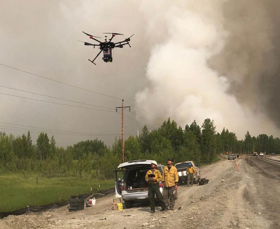
Lakeview IHC drone Operation
File photo of the Lakeview Hotshots using a drone to assist with a burn operation in Alaska in 2019.

With the firing activity taking place 2 to 5 miles north and northeast of the fire, the Rafael Fire is now:

      • 6 miles south of Interstate 40
      • 11 miles southwest of Flagstaff
      • 7 miles west of Highway 89A, and
      • 8 miles northwest of Sedona

Evacuation information is available on Facebook for Coconino and Yavapai Counties.

On Friday widespread cloud cover and lighter winds reduced active fire movement throughout much of the fire area. But it picked up in the early afternoon in Sycamore Canyon, Hog Hill, and Mooney Canyon.

The Incident Management Team reported Saturday morning the fire had burned 45,899 acres. That number is likely to increase after the overnight mapping is accounted for.

The Rafael Fire now involves the Prescott, Kaibab, and Coconino National Forests and Yavapai and Coconino Counties.

On June 24 the Southwest Area Type 1 Incident Management Team 2 led by Incident Commander Dave Bales assumed command of the fire.

Weather prevented firefighters from continuing firing operations Tuesday night on the Backbone Fire

The fire has burned over 38,000 acres near Strawberry, Arizona

2:28 p.m. MDT June 23, 2021

Backbone Fire June 22, 2021
Backbone Fire 8:23 a.m. MDT, June 22, 2021.

The weather Tuesday night made it impossible to obtain heat sensing data from satellites or fly the fixed wing mapping aircraft to obtain the latest perimeter information for the Backbone Fire. It also prevented additional firing operations along Highway 260. The last time the fire was mapped it was 38,321 acres.

On the west side, crews continue to monitor the fire as it nears the east side of the Verde River. Contingency lines near Beasley Flat and Camp Verde are being improved. Preparation efforts also continue along State Route 260 and near structures and other infrastructure for additional firing operations. Firefighters continue to hold, patrol, and secure the east side of the fire. Personnel and aircraft are working in the southeast area, including Hardscrabble Canyon and Deadman Mesa, to prevent fire from becoming established in the drainage.

To see all articles on Wildfire Today about the Backbone Fire, including the most recent, click HERE.

The communities of Pine and Strawberry are still under evacuation orders.

Firefightrers install defensive sprinkler system
Firefighters install defensive sprinkler system in the Strawberry area. InciWeb photo.

Rafael Fire spread about 4 miles to the east Tuesday

9:05 a.m. MDT June 23, 2021

Rafael Fire map
Rafael Fire map. The red dots represent heat detected by a satellite at 3:54 a.m. MDT June 23, 2021. The red line was the mapped perimeter at 8:39 p.m. June 22.

Not much information is available about the Rafael Fire from the Incident Management Team (IMT). The Yavapai County Sheriff’s Office posted this on Facebook:

Based on information recently received from fire incident command. Some rural ranches in the area of North FSR 525 and Bill Grey Road, West of Sedona, have been notified, in person, of a “Go” status. Several additional properties were placed on “Set” status via in person notification. YCSO will continue to work with the fire incident command on this fire and assess the need for any other “ready”, “set” or “go” alerts that will be sent out through our Code Red Emergency notification system.

If you are not signed up for Code Red you can sign up at https://www.ycsoaz.gov/…/Emergency-Notification-System if you live in Yavapai County and https://www.coconino.az.gov/ready if you live in Coconino County. We will also continue to post updates here on our Facebook page.

The Arizona Central West Type 3 IMT is managing the 26,746-acred Rafael Fire plus six other wildfires that range from 27 to 567 acres.

To see all articles on Wildfire Today about the Rafael Fire, including the most current, click HERE.

The fire was active on the northeast and east sides during the day Tuesday and into the night. Based on satellite heat detection data at 3:54 a.m. Wednesday it spread north about a mile and to the east more than four miles in the previous 24 hours. Most of the south and west sides were relatively quiet.

The Rafael Fire is now about 9 miles northwest of Sedona and 17 miles southwest of Flagstaff.

Rafael Fire
Rafael Fire. Photo by Yavapai County Sheriff’s Office, posted June 22, 2021.

The Wyrick Fire grows to 7,452 acres north of Heber-Overgaard, AZ

Updated 12:37 p.m. MDT June 24, 2021

Rainbow in the Wyrick Fire area
Rainbow in the Wyrick Fire area, June 23, 2021. Photo by Jeff Zimmerman.

Showers slowed the spread of the Wyrick Fire Wednesday. It was not enough to completely extinguish the fire, but it was a wetting rain a local told us, that reduced the rate of spread for a while.

The evacuations have been cancelled, and residents can return to their homes.

The precipitation will give firefighters an opportunity to build fireline directly next to the fire, taking advantage of the temporary reprieve to make progress toward containment.

On Wednesday, the West Chev Fire seven miles west of the Wyrick Fire remained active. Helicopters were used to keep the fire from moving to the south in the timber that lines the steep canyons. Firefighters are assessing how to safely construct fireline to contain the blaze.

The Incident Management Team reported Thursday that the Wyrick Fire had burned 7,452 acres.  Clouds prevented satellites and mapping aircraft from gathering intelligence about the two fires Wednesday night.


10:26 a.m. MDT June 22, 2021

map Wyrick and West Chev Fires
The red dots represent heat detected on the Wyrick and West Chev Fires at 4:12 a.m. MDT June 22, 2021 by a satellite. The red line was the perimeter of the Wyrick Fire at 4:29 a.m. MDT June 22.

The Wyrick Fire was active on the eastern two-thirds of the fire on Monday but did not make any massive runs. A mapping flight early Tuesday morning determined it had burned about 7,100 acres and was about three miles from Heber-Overgaard.

To see all articles on Wildfire Today about the Wyrick Fire, including the most recent, click HERE.

Evacuations are in effect. The Incident Management Team (IMT) announced on Monday:

Areas in READY Status: Overgaard south of Highway 260 High Country Pines in Heber Kendall Ranch / Camp Ponderosa.

Areas in SET Status: Areas in Heber not identified as Ready or Go status Chevelon Ranches and Retreat Communities in Overgaard south of Highway 277 and North of Highway 260.

Areas in GO Status (leave now): Antelope Valley Despain Ranch Heber and Overgaard North of 260 AND 277.

A Type 2 IMT led by Incident Commander Mark Bernal is scheduled to assume management of the fire Tuesday, June 22.

Another fire is burning 7 miles west of the Wyrick Fire. The West Chev Fire has burned 288 acres 14 miles northwest of Heber-Overgaard.

Wyrick Fire
Wyrick Fire. USFS photo.

Firefighters begin firing operation on Hwy 260 to defend against Backbone Fire

Near Strawberry, Arizona

7:47 a.m. MDT June 22, 2021

3-D map of the Backbone Fire
3-D map of the Backbone Fire, looking west at 3:24 a.m. MDT June 22, 2021. The red dots along Highway 260 represent heat from the firing operation. The location of the dots is approximate.

Monday night firefighters began what will be a massive firing operation to defend against the 37,000-acre Backbone Fire that is threatening the communities of Strawberry and Pine, Arizona. The operation began at the intersection of highways 260 and 87 with crews working north and south on Highway 260. The stated goal of the project is to remove the fuel between Strawberry and Fossil Creek in order to protect the community.

To see all articles on Wildfire Today about the Backbone Fire, including the most recent, click HERE.

It is unknown how far the Incident Management Team intends to take the firing operation but I did some calculations. If the fire stayed where it is early Tuesday morning and they quickly completed the firing operation, it would encompass at least 20,000 to 40,000 acres.

Backbone Fire map
On this map of the Backbone Fire the red dots represent heat detected by a satellite at 3:24 a.m. MDT June 22, 2021. The red line was the perimeter at 2 a.m. The white line was the perimeter about 24 hours earlier. The red dots show the firing operation that began at the intersection of Highways 260 and 87. The red dots at upper-right north of 260 and 209 is the 71-acre Snake Fire.

The Incident Management Team said that Monday the fire continued to advance up Fossil Creek toward Highway 260.

Mapping and satellite data show the northeast part of the fire which is northwest of Strawberry has moved northeast over the last 24 hours, closer to Highway 260.

The fire has continued to spread to the northwest in the direction of Camp Verde, advancing less than a mile on Monday.

Firefighters have been working to construct firelines and improve the protection for Strawberry.

Pine and Strawberry are still under evacuation orders.

A new fire is burning 7 miles north of the intersection of Highways 260  and 87, visible on the map above at the upper-right. It is the 71-acre Snake Fire being managed separately.

Firing operation Backbone Fire
Firing operation on the Backbone Fire at the junction of Highways 260 and 87, June 21, 2021. Photo by Arizona Department of Transportation.

Rafael Fire grew rapidly Sunday, 12 miles northwest of Sedona, AZ

It has burned about 24,000 acres 20 miles southwest of Flagstaff

Updated at 9:16 a.m. MDT June 22, 2021

Rafael Fire map
Rafael Fire map. The red dots represent heat detected by a satellite at 4:12 a.m. MDT June 22, 2021. The red line was the mapped perimeter at 2:38 a.m. June 22. The white line was the approximate perimeter about 24 hours before.

The Rafael Fire 12 miles northwest of Sedona, Arizona was not as active Monday as in previous days. A satellite overflight at 4:12 a.m. Tuesday found heat along the eastern three-fourths of the fire perimeter, but the growth was incremental, advancing less than a mile to the north, east, and south. It has advanced on the eastern side to the bottom of Sycamore Canyon and Tule Canyon just southwest of Sycamore Point.

To see all articles on Wildfire Today about the Rafael Fire, including the most current, click HERE.

A mapping flight at 2:38 a.m. Tuesday determined the Rafael Fire had burned about 24,000 acres.


Updated at 7:40 p.m. MDT June 21, 2021

The latest satellite overflight Monday at 3 p.m. MDT showed that the Rafael Fire continued to be active along portions of the north and south sides during the previous 12 hours, but at that time had not made any large runs. Later in the afternoon fire activity increased substantially.

We expect to have more detailed information including an updated map Tuesday morning.

The Coconino County website has evacuation information.


12:56 p.m. MDT June 21, 2021

map Rafael Fire
The red areas on the map represent heat detected on the Rafael Fire by satellites at 3:42 a.m. MDT June 21, 2021. The red line was the perimeter about five hours earlier.

The lightning-caused Rafael Fire 12 miles northwest of Sedona, Arizona grew substantially Sunday while being pushed by strong winds. After spreading to the east-northeast, early Monday morning it was about 12 miles southwest of Flagstaff. The Incident Management Team reported Monday morning it was mapped at about 20,000 acres.

The blaze began as four fires ignited by lightning last week that burned together during the wind event Sunday. It now spans across three National Forests (Prescott, Kaibab, and Coconino) and two counties (Yavapai and Coconino).

A Type 1 Incident Management Team has been ordered.

For the most current evacuation information visit the sites below:

Rafael Fire, June 20, 2021.
Rafael Fire, June 20, 2021. InciWeb photo.