It has burned more than 136,000 acres 12 miles southwest of Lake Tahoe
7:51 a.m. PDT August 26, 2021
Map of the Caldor Fire. The pink line was the perimeter mapped by a fixed wing aircraft at 12:23 a.m. PDT August 26, 2021. The blue line was the perimeter 50 hours earlier. The pink shaded areas had extreme heat during the mapping flight.
The northeast side of the 136,000-acre Caldor Fire 12 miles southwest of Lake Tahoe was active Wednesday night. The fire added about 10,000 acres over the last 24 hours. The spot fire north of Highway 50 has continued to spread east, growing to approximately 2,600 acres. The photo below was taken in that area.
To see all articles on Wildfire Today about the Caldor Fire, including the most recent, click HERE.
Caldor Fire, Wrights Lake Road north of Hwy. 50, Aug. 25, 2021. CAL FIRE photo.
The weather forecast for Thursday predicts 7 to 8 mph winds out of the southwest and northwest with relative humidity in the teens. Friday will be about the same but with lower humidity. These conditions will allow the fire to keep spreading.
Resources assigned as of Wednesday evening included 243 fire engines, 27 water tenders, 21 helicopters, 80 hand crews, and 51 dozers for a total of 2,897 personnel.
3-D map of the northeast end of the Caldor Fire looking northeast. The red line was the perimeter at 10:07 p.m. PDT August 24, 2021.
Firefighters on the 126,000-acre Caldor Fire are hoping to slow the spread with extensive use of dozers. They are constructing firelines out ahead from which they plan to ignite backfires or other burning operations. This will remove the available fuel so that when the fire reaches those barriers it will stop, at least at those locations.
The fire is still about 14 miles southwest of Lake Tahoe.
On the map below produced by the Incident Management Team the “xxxxxx” indicates dozer lines completed at the end of the day August 24. Crews are working on extending these lines and tying in the various segments. Air tankers are slowing the spread on the northeast side in Division J to give the dozers time to complete the lines.
Map of the Caldor Fire, by the Incident Management Team for day shift August 25, 2021.
On Wednesday the fire primarily spread to the northeast along Highway 50 toward Twin Bridges. Firing operations continued on the southwest side but were slowed by numerous small spot fires that were quickly extinguished. The north side of the fire is backing downhill to the north toward Highway 50 achieving results not unlike a well-planned prescribed fire.
The spot fire across Highway 50 has grown to about 2,000 acres and spotted to the east across Wrights Lake Road.
The weather conditions recorded at Barney Ridge were moderate in the afternoon with 5 to 8 mph winds gusting at 12 to 16 mph out of the southwest while the relative humidity was around 20 percent. The forecast for Thursday is for 8 to 11 mph winds out of the west with humidity in the mid-teens.
The fire has destroyed 465 residences and 178 other structures. The El Dorado County Sheriff in collaboration with CAL FIRE has released a map displaying properties that have been inspected for any damage or that have been destroyed by the Caldor Fire.
Fire history in vicinity of the Caldor Fire, 2000 through August 23, 2021.
In order for the spread of the 117,000-acre Caldor Fire to stop or to be suppressed by firefighters, something will have to change — either the weather or the fuel.
If the relative humidity stayed above 40 percent and the wind speed was less than five mph, it might lose enough intensity to allow firefighters on the ground and in the air to take direct action on the flanks. But there is no sign of that happening this week.
To see all articles on Wildfire Today about the Caldor Fire, including the most recent, click HERE.
Let’s look at the fuel, which is the primary driver of this fire.
From the Incident Management Team:.
There is a heavy dead and down component with drought-stressed fuels. Live fuels are cured to levels normally seen in late September, and fuels are extremely receptive to spotting. Fuel moistures are historically low. Northern California remains under a Fuels and Fire Behavior Advisory. ERC’s are above the 97th percentile. 100 hr and 1000hr fuels are below [3 percent fuel moisture].
The predominant direction of spread has been to the northeast or east-northeast. If it continues in that direction for the next 10 miles it will not encounter the footprints of any fires that have burned in the last 21 years large enough to have a significant effect on the spread. Just beyond that distance on the north side of Highway 50 is the 2007 Angora Fire southwest of South Lake Tahoe.
North of Highway 50 four miles northeast of the location of the fire Monday night there is a large rocky area several miles across with sparse fuel. It is north of Twin Bridges and west of Fallen Leaf and could slow the fire in that location, but there’s no guarantee that it can’t find a way to burn around, through, or over it. Spot fires have been igniting a mile out in front; one was 1.8 miles.
Hazardous fuel treatments in vicinity of the Caldor Fire, 2000-2021.
Another fuel-related factor to consider is the fuel treatments that have been accomplished over the years, shown in green on the map above. The Caldor Fire has already burned across dozens, and it will be interesting to find out if they had the intended effect. There has been a great deal of fuels work in the South Lake Tahoe area.
A reduction in the volume of vegetation resulting from a fuels project in most cases is not expected to stop a high-intensity wildland fire. At best in those areas the fire may spread more slowly and perhaps throw out fewer burning embers.
But by far the best protection for structures is make them as fire resistant as possible, including the envelope of the structure itself — the roof, vents, siding, doors, windows, foundation, fences, eaves, and decks. A FEMA publication (13 MB) has excellent detailed recommendations. And in the Home Ignition Zone the NFPA and FireWise programs recommend reducing flammable material within 100 feet of structures and spacing the crowns of trees at least 18 feet apart that are within 30 feet of the home, 12 feet apart at 30 to 60 feet, and 6 feet apart at 60 to 100 feet. Another house that is 15 to 50 feet away is also fuel, and if it ignites will be a serious threat.
The LA Times (subscription) published an excellent article August 21 about rethinking forest management — the effects of logging and prescribed fire, and learning to live with fire.
455 residences, 1 school, a post office, and 2 fire stations have been destroyed
10:21 a.m. PDT August 24, 2021
Map of the Caldor Fire. The black line was the perimeter during a mapping flight at 11:17 p.m. PDT August 23, 2021. The blue line was the perimeter about 30 hours earlier. Red dots represent heat detected by a satellite at 2:11 a.m. PDT August 24, 2021. Dark red areas had intense heat during the last mapping flight.
The Caldor Fire grew by about 10,000 acres Monday under the influence of a 6 mph wind gusting out of the south, southwest, and west at 8 to 15 mph while the relative humidity was in the high 20s. Most of the activity was on the southeast and northeast sides. So far crews have been able to keep it south of Highway 50 except for a spot fire near Granite Springs Road that has burned several hundred acres. During a Monday night mapping flight the fire was about two miles southwest of Sciots Camp and 14 miles southwest of Lake Tahoe.
The fire was mapped Monday night at 117,000 acres.
Monday night fire activity moderated overall, but with some small spot fires and significant terrain-driven runs on the southeast side. Humidity recovery allowed crews to engage in direct control tactics and to continue indirect line construction.
To see all articles on Wildfire Today about the Caldor Fire, including the most recent, click HERE.
The Incident Management Team (IMT) reported Monday that in three or more days the following areas have the potential to be threatened: Silver Lake, Kit Carson, Plasse, Kirkwood, Twin Bridges, Sierra-at-Tahoe, Caples Lake, and the Lake Tahoe Basin.
Monday the IMT identified a long list of “critical resource needs” requested by today, Monday, including 330 engines, 60 hand crews, 17 Division Supervisors, and 40 other overhead personnel.
The weather forecast predicts very challenging conditions for firefighters over the next two days — strong winds Tuesday afternoon, 13 mph gusting out of the south-southwest at 20 mph, with 30 percent relative humidity and 70 degrees. Overnight the wind will slow to 6 mph from the southwest, then increase again Wednesday, 14 to 17 mph gusting up to 26 mph from the southwest with the RH in the low 20s.
This weather combined with the historically low fuel moistures could result in very significant growth of the fire Tuesday and Wednesday.
Damage inspections are in progress with approximately 40 percent of the current fire perimeter having being inspected. Crews have documented the destruction of 455 residences and 11 commercial structures. On the list of structures destroyed are one school, a church, a post office, and two fire stations (Grizzly Flats Forest Service and Pioneer Fire Dept. Station 35). PG&E currently has about 3,000 customers without power.
The El Dorado County Sheriff in collaboration with CAL FIRE has released a map displaying properties that have been inspected for any damage or that have been destroyed by the Caldor Fire.
Satellite photo showing smoke from wildfires at 5:51 p.m. PDT Aug 23, 2021.
The 104,000-acre fire is 14 miles southwest of Lake Tahoe
Updated 10:09 a.m. PDT August 23, 2021
Caldor Fire map. The black line was the perimeter during a mapping flight at 5:25 p.m. PDT Aug. 22, 2021. The interior blue line was the perimeter about 18 hours before. The red dots represent heat detected by a satellite at 3:51 a.m. PDT Aug 23, 2021.
The Caldor Fire in northern California 14 miles southwest of Lake Tahoe did not spread as much Sunday as it did Saturday when it ran four miles to the northeast. Still, it added about 6,000 acres to bring the total up to 104,309 acres.
Most of the growth Sunday was on the northeast side near Kyburz, on both sides of Highway 50 where spot fires occurred up to a half-mile ahead of the main fire front. A spot fire north of the highway south of Granite Springs Road grew substantially. Under the existing conditions of weather and fuel moisture, burning embers lofted into the air easily ignite the very dry fuels.
To see all articles on Wildfire Today about the Caldor Fire, including the most recent, click HERE.
On Monday firefighters expect southwest winds to continue, with ridgeline winds of 4-9 mph. Fire growth will occur in all areas, especially on the north and northeast flanks. A minimal inversion and smoke layer should clear before noon, with fire activity increasing quickly, aided by the up-canyon breezes. Smoldering spot fires will begin to become active once exposed to the wind and sunny conditions. New spot fires could occur up to a mile ahead of the main fire front.
Diurnal wind patterns will likely cause the Caldor Fire to send smoke into the Lake Tahoe Basin during the day. After sunset a down canyon flow will cause smoke to drain down the Highway 50 corridor into Placerville and the Eldorado hills overnight.
Night flying helicopters are being used to drop water at night for the first time in Northern California. On August 18 a group of three large helicopters that can carry 1,000 to 3,000 gallons was dispatched to the area from the southern part of the state. Since arriving they have been stymied by visibility problems caused by smoke trapped in inversions, but at least one was flying Sunday night. The video below shows the smallest of the three large ships, a 1,000-gallon Sikorsky S-61, dropping on the Caldor Fire. The other two are 3,000-gallon CH-47D Chinooks.
Due to extreme fire conditions and “strained firefighter resources throughout the country” the US Forest Service has enacted a temporary closure of nine National Forests in California: Tahoe, Plumas, Lassen, Mendocino, Klamath, Six Rivers, Shasta-Trinity, Modoc, and Lake Tahoe Basin Management Unit.
9:05 a.m. PDT August 22, 2021
Caldor Fire map. The black line was the perimeter during a mapping flight at 9:15 p.m. PDT Aug. 21, 2021. The green line was the perimeter about 24 hours before. The red dots represent heat detected by a satellite at 2:30 a.m. PDT August 22, 2021. The dark red areas had extreme heat during the last mapping flight.
The northeast side of the Caldor Fire ran for more than four miles Saturday, growing to 98,000 acres while being pushed by 8 to 10 mph winds out of the southwest gusting to 20 mph. The relative humidity measured at the Barney Ridge weather station south of the fire on Omo Ranch Road never dropped below 30 percent, which likely moderated the spread.
The fire activity slowed Saturday night as the wind decreased but spot fires were still occurring.
The weather forecast for Sunday is for high temperatures in the 70s, relative humidity 25 to 32 percent, and afternoon winds becoming southwest at 5 to 9 mph with 15 mph gusts.
The fire is along Highway 50, 14 miles southwest of Lake Tahoe and 36 miles east of the Sacramento suburbs.
During a fixed wing mapping flight at 9:15 Saturday night the Caldor Fire was less than a mile from Highway 50 in several places, but was still mostly south of the highway. A significant spot fire had become established north of the road near Kyburz.
Caldor Fire vicinity map, 9:15 p.m. PDT Aug 21, 2021.
As it spread over four miles Saturday there were numerous spot fires caused by lofted burning embers out ahead of the fire. One of the spots southwest of Sciots Camp was was documented 1.8 miles from the main front.
Firefighters expect the growth to continue Sunday in all areas, with minimal growth at the southern and eastern portions, and major growth continuing on the north and northeastern sides. Spot fires will occur a half mile ahead. The Probability of Ignition will be 87 percent, meaning 87 percent of lofted firebrands that land in receptive fuels will ignite the fuel. The wind may clear much of the smoke out making it possible for air tankers and helicopters to assist firefighters, but they may be limited or ineffective due to the wind speeds.
Officials reported that 235 residences have been destroyed, an increase of 56 from yesterday.
Resources assigned to the fire Saturday evening included 28 hand crews, 194 fire engines, 22 dozers, 15 water tenders, and 20 helicopters for a total of 1,603 personnel.
Nationally, 26,123 personnel are working on wildfires today. Six of the eight military C-130 aircraft equipped with Modular Airborne FireFighting Systems which convert them to air tankers have been activated.
Can the fire be stopped?
If it has not happened already, by the end of the day on Sunday the fire will reach the 100,000-acre threshold to be called a “megafire”– a status that until a decade or two ago was rare.
Under these conditions with the predicted weather, the heavy fuel loads, and historically low fuel moistures, there is no possibility of stopping the forward spread of the fire. There is no number of 747 air tankers or firefighters on the ground that could be effective against the flaming front of this raging inferno. The best they can hope for is to find areas on the heel and flanks where the topography and vegetation are conducive to constructing indirect or direct fire lines, and firing out when appropriate, perhaps at night when weather conditions are more likely to lead to success.
Fire officials have documented the destruction of 179 residences
8:28 a.m. PDT August 21, 2021
Caldor Fire map. The black line was the perimeter at 8:25 p.m. Aug. 20, 2021. The red dots represent heat detected by a satellite at 3:09 a.m. PDT Aug 21.
The 82,000-acre Caldor Fire southwest of Lake Tahoe is under a Red Flag Warning Saturday for conditions that could push the blaze northeast toward Highway 50.
The updated weather forecast for the fire area Saturday at 4,400 feet is for 14 mph southwest winds beginning at 11 a.m. gusting to 21 mph. The relative humidity will drop from the overnight high of 55 to 60 percent to the high 20s. There will be a 35 percent cloud cover with a high of 75 degrees.
To see all articles on Wildfire Today about the Caldor Fire, including the most recent, click HERE.
About two-thirds of the fire perimeter was active enough Friday night and early Saturday morning for satellites to detect intense heat.
Firefighters reported that winds decreased during the night and spot fires continued to become established in the dense timber stands and clear cuts due to the large amount of extremely dry dead and down material. The increase in relative humidity during the night allowed crews to conduct firing operations.
On the east side, satellites detected heat at 3:09 a.m. north of the Omo Ranch, and south, east, and northeast of Jenkinson Reservoir. The fire was also very active on the entire east side near Morrison, Iron Mountain, Iron Mountain Ridge, Voss, Meiss, and Caldor. At that time the fire was less than a mile south of Highway 50 at Riverton, and about two miles south of the highway near Kyburz. On the south side, satellite data overnight detected it was two miles north of Highway 88 at the closest point, Gold Note Ridge.
Crews have documented 179 residences that have been destroyed. Approximately 15,000 remain threatened.
Resources assigned to the fire Friday evening included 28 crews, 142 fire engines, and 20 helicopters for a total of 1,558 personnel.
8:27 p.m. PDT August 20, 2021
Caldor Fire map. The red dots represent heat detected by an aircraft at 2:48 p.m. PDT August 20, 2021. The fire perimeter was mapped earlier.
With strong winds in the forecast for Saturday officials have closed a portion of Highway 50 near the Caldor Fire which has burned over 75,000 acres 18 miles southwest of Lake Tahoe in California.
The closure began at 4:30 p.m. Friday. Highway 50 will be closed in both directions from the Sly Park Road exit to Twin Bridges. It will be open between Meyers and Twin Bridges for local residents only who reside between Meyers and Twin Bridges. These residents will be subject to providing identification and proof of residency. No traffic will be allowed west of Twin Bridges. (This information was acquired at 7 p.m. PDT Friday, Aug. 20, 2021, and could change.)
At 3 p.m. Friday the north edge of the Caldor Fire was about a half mile south of the highway. (See the map above.) A Red Flag Warning will be in effect Saturday from 11 a.m. through 8 p.m. The weather forecast for Saturday at 4,600 feet is for southwest and west-southwest winds beginning at 8 a.m. increasing in strength by 11 a.m. to 16 mph gusting to 25 mph, or 30 mph in some areas. The relative humidity will drop to 25 percent or lower. Skies will be clear with a high of 75 degrees.
Strong winds with no cloud cover and 25 percent humidity could push the fire to Highway 50 and possibly across the roadway. However a dense smoke layer could reduce solar preheating of the fuels and attenuate the spread somewhat. The Hot-Dry-Windy Index for Saturday predicts the area will be below the 50th percentile, which would not indicate extreme spread of a fire. This weather event will be a good test of the Index.
Many areas are under evacuation orders. InciWeb has the details.
On Friday the fire activity increased after noon when the wind began coming out of the south at 6 to 10 mph gusting to 23.
The fire spread is being driven by a heavy component of dead and down fuels and drought-stressed vegetation. Live fuels are cured to levels normally seen in late September, and the vegetation is extremely receptive to spotting. Fuel moistures are historically low.
Fire officials have documented the destruction of 118 residences.
Resources assigned to the fire include 18 crews, 109 fire engines, and 13 helicopters for a total of 1,118 personnel.
USFS engine crews on the initial attack of the Caldor Fire, August 14, 2021. USFS photo.
It has burned more than 62,000 acres 18 miles southwest of Lake Tahoe
8:57 p.m. PDT August 19, 2021
Caldor Fire map. The white line was the perimeter at 8:20 p.m. August 18, 2021. The red areas represent heat detected by an aircraft at 6:44 p.m. PDT Aug. 19, 2021.
Fire behavior on the Caldor Fire was moderated most of the day Thursday by an inversion, but activity picked up after 3 p.m. It was mapped at 68,630 acres Thursday afternoon.
The map above shows in red the areas of intense heat at 6:44 p.m. Thursday. An aircraft detected a small amount of growth on the northwest and southeast sides, but the fire was more active around the spot fires northeast of the main fire.
To see all articles on Wildfire Today about the Caldor Fire, including the most recent, click HERE.
The Caldor Fire has not moved much closer to Highways 50 and 88. It is 18 miles southwest of Lake Tahoe.
10:02 a.m. PDT Aug. 19, 2021
Caldor Fire map. The white line was the perimeter at 8:20 p.m. August 18, 2021. The green line was the perimeter 24 hours earlier. The red dots represent heat detected by a satellite at 1:45 a.m. PDT Aug. 19. The brown areas had extreme heat Wednesday evening.
The Caldor Fire east of Placerville, California was active Wednesday but not nearly to the degree seen on Tuesday when it ran for miles to the northeast. Most of the growth Wednesday was on the northeast side. During an 8:30 p.m. mapping flight it was still completely south of Highway 50 except for a spot fire that was suppressed at the highway near Riverton seven miles east of Pollock Pines. The size reported by the Incident Management Team Wednesday evening was 62,000 acres.
Many structures have been destroyed, including in Grizzly Flats, but evaluation teams have not yet been able to get into the burned areas and report the details.
A large number of spot fires on the northeast side near Morrison and Pilliken are in the process of merging to form a large finger of fire two miles south of Kyburtz.
The wind at a weather station northwest of the fire on Pleasant Valley Road (Placer) has been recording winds from the southwest since 11 a.m. Wednesday with the exception of a few hours very early Thursday morning. This accounts for the spread to the northeast. Wednesday afternoon the speed was 4 to 6 mph with gusts at 8 to 12 mph. The relative humidity was in the 40s, pretty high for California in the summer, which limited the movement of the fire.
The forecast for the fire area at 4,700′ Thursday could lead to more active fire behavior than on Wednesday. It predicts 6 to 10 mph winds in the afternoon out of the west-northwest, temperature 85 degrees, and relative humidity in the high teens. Friday will be about the same, but with winds out of the southwest. No chance of rain.
Fire resources assigned to the fire Wednesday evening included 11 hand crews, 61 engines, 20 dozers, 10 water tenders, and no helicopters for a total of 601 personnel. Fire personnel state that the limited number of resources available presents a significant challenge.
The Sacramento Bee reported that Wednesday CAL FIRE transferred 30 fire engines from the Dixie Fire to the Caldor Fire due to a greater need at the time.
“They were released from the Dixie Fire and sent straight over the hill because they were the closest resources available,” CAL FIRE director Thom Porter said.
Quick Reaction Force of helicopters dispatched to Westover Field near the Caldor Fire. Coulson image.
A group of three large helicopters that has been on contract in three Southern California counties since June 15, called a Quick Reaction Force, has been dispatched to Northern California. Carrying from 1,000 to 3,000 gallons each, they all will be working 24/7 and have the capability of dropping water or retardant on a fire at night, as well as the ability to refill while hovering at night. They will be based just north of Jackson at Amador County Airport, also known as Westover Field 18 miles southwest of the Caldor Fire. It is unclear where they will be used — to support the Caldor Fire, other large fires, or for initial attack on new fires.
7:02 p.m. PDT August 18, 2021
Vicinity map of the Caldor Fire. The white line was the perimeter during a fixed wing mapping flight at 8:20 p.m. PDT August 17, 2021. The red areas represent heat detected by a satellite at 1:27 p.m . PDT Aug 18, 2021. The brown area was intense heat Tuesday night.
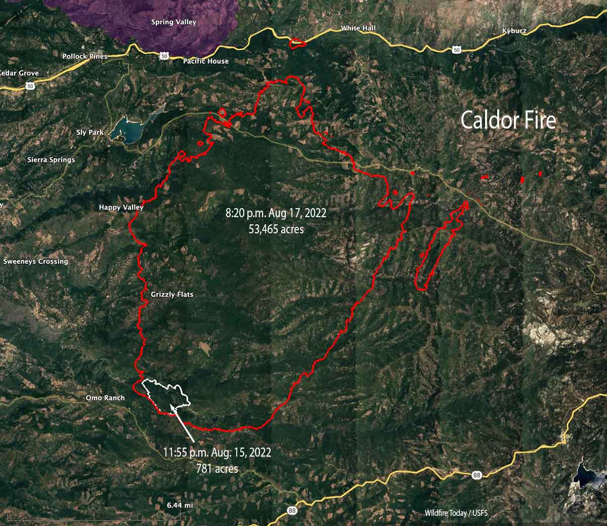
The Caldor Fire near Pollock Pines in Northern California has grown rapidly since it was reported at 7 p.m. on August 14. With it now covering more than 53,000 acres, the Sheriff’s Offices in Eldorado and Amador Counties have ordered evacuations in the face of what firefighters are calling unprecedented fire behavior. CAL FIRE has a list of evacuation orders.
At 1:27 p.m. PDT August 18, a satellite showed it was 18 miles southwest of Lake Tahoe, 12 miles east of Placerville, 3 miles southeast of Pollock Pines, and was about a half mile south of Highway 50. However, a spot fire was detected at Highway 50 near Riverton.
Map of the Caldor Fire. The white line was the perimeter during a fixed wing mapping flight at 8:20 p.m. PDT August 17, 2021. The red areas represent heat detected by a satellite at 1:27 p.m . PDT Aug 18, 2021. The brown area was intense heat Tuesday night.
On Tuesday structures were damaged or destroyed. Assessment teams will evaluate the areas as soon as the access is safe.
The fire is being driven by heavy drought-stressed fuels at record setting low moisture levels and large amounts of dead and down material in steep drainages that were in alignment with the northeast winds.
Firefighters expect the active fire behavior to continue through Thursday. One of the challenges they are facing is an inadequate number of firefighting resources.