
8:57 p.m. PDT August 19, 2021

Fire behavior on the Caldor Fire was moderated most of the day Thursday by an inversion, but activity picked up after 3 p.m. It was mapped at 68,630 acres Thursday afternoon.
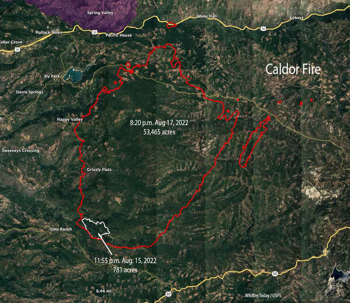
The map above shows in red the areas of intense heat at 6:44 p.m. Thursday. An aircraft detected a small amount of growth on the northwest and southeast sides, but the fire was more active around the spot fires northeast of the main fire.
To see all articles on Wildfire Today about the Caldor Fire, including the most recent, click HERE.
The Caldor Fire has not moved much closer to Highways 50 and 88. It is 18 miles southwest of Lake Tahoe.
10:02 a.m. PDT Aug. 19, 2021

The Caldor Fire east of Placerville, California was active Wednesday but not nearly to the degree seen on Tuesday when it ran for miles to the northeast. Most of the growth Wednesday was on the northeast side. During an 8:30 p.m. mapping flight it was still completely south of Highway 50 except for a spot fire that was suppressed at the highway near Riverton seven miles east of Pollock Pines. The size reported by the Incident Management Team Wednesday evening was 62,000 acres.
Many structures have been destroyed, including in Grizzly Flats, but evaluation teams have not yet been able to get into the burned areas and report the details.
A large number of spot fires on the northeast side near Morrison and Pilliken are in the process of merging to form a large finger of fire two miles south of Kyburtz.
The wind at a weather station northwest of the fire on Pleasant Valley Road (Placer) has been recording winds from the southwest since 11 a.m. Wednesday with the exception of a few hours very early Thursday morning. This accounts for the spread to the northeast. Wednesday afternoon the speed was 4 to 6 mph with gusts at 8 to 12 mph. The relative humidity was in the 40s, pretty high for California in the summer, which limited the movement of the fire.
The forecast for the fire area at 4,700′ Thursday could lead to more active fire behavior than on Wednesday. It predicts 6 to 10 mph winds in the afternoon out of the west-northwest, temperature 85 degrees, and relative humidity in the high teens. Friday will be about the same, but with winds out of the southwest. No chance of rain.
Fire resources assigned to the fire Wednesday evening included 11 hand crews, 61 engines, 20 dozers, 10 water tenders, and no helicopters for a total of 601 personnel. Fire personnel state that the limited number of resources available presents a significant challenge.
The Sacramento Bee reported that Wednesday CAL FIRE transferred 30 fire engines from the Dixie Fire to the Caldor Fire due to a greater need at the time.
“They were released from the Dixie Fire and sent straight over the hill because they were the closest resources available,” CAL FIRE director Thom Porter said.
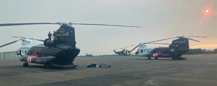
A group of three large helicopters that has been on contract in three Southern California counties since June 15, called a Quick Reaction Force, has been dispatched to Northern California. Carrying from 1,000 to 3,000 gallons each, they all will be working 24/7 and have the capability of dropping water or retardant on a fire at night, as well as the ability to refill while hovering at night. They will be based just north of Jackson at Amador County Airport, also known as Westover Field 18 miles southwest of the Caldor Fire. It is unclear where they will be used — to support the Caldor Fire, other large fires, or for initial attack on new fires.
7:02 p.m. PDT August 18, 2021

The Caldor Fire near Pollock Pines in Northern California has grown rapidly since it was reported at 7 p.m. on August 14. With it now covering more than 53,000 acres, the Sheriff’s Offices in Eldorado and Amador Counties have ordered evacuations in the face of what firefighters are calling unprecedented fire behavior. CAL FIRE has a list of evacuation orders.
At 1:27 p.m. PDT August 18, a satellite showed it was 18 miles southwest of Lake Tahoe, 12 miles east of Placerville, 3 miles southeast of Pollock Pines, and was about a half mile south of Highway 50. However, a spot fire was detected at Highway 50 near Riverton.

On Tuesday structures were damaged or destroyed. Assessment teams will evaluate the areas as soon as the access is safe.
The fire is being driven by heavy drought-stressed fuels at record setting low moisture levels and large amounts of dead and down material in steep drainages that were in alignment with the northeast winds.
Firefighters expect the active fire behavior to continue through Thursday. One of the challenges they are facing is an inadequate number of firefighting resources.

My family vacation in South Lake Tahoe for Labor Day weekend is looking bleak. Those that live there, please keep replying on the fire status. We want to stay safe and pray for those that live in the Lake Tahoe community.
I live in South Lake Tahoe, Can., the smoke here is “horrific’! This has been a terrible summer and by the looks of it, Fall won’t be much better. The Caldor fire is about 15 miles from us and the wind is blowing it our way. Wouldn’t be surprised if we have to evacuate in the coming week or so.
How can assesment not get in but the media can ????
Dear god in heaven if you do exsist please stop the caldor fire!!!!!!!!!!!!!!!!!!!!!!!
There are over 1,100 Firefighters on the fire now trying their best to stop the fire. However, “Nature Bats Lasts.”
Thank you.
p.s. I’m learning new things from you. Fire Aviation very interesting.
What is the evacuation area east of placerville, I live in Camino.
Here’s a link to the Cal Fire page with evacuation order and warning information. https://www.fire.ca.gov/incidents/2021/8/14/caldor-fire/
Thank you for the map. I pray everyone stays safe. ?
Just sucks a lot of peoples home and houses and family cabins are going to be burned down just like that. Including my family’s
Sadly, it sounds like tonight the fire is also bumping up against Hwy. 88 to the south of the fire. Unimaginable growth to those familiar with the wonderful forest and the communities.
Your map is very helpful. Thanks,
Finally a map that represents the fires edge and activity level; that has accurate mileage descriptions of distances from improvements and spot (s) fires outside the perimeter. Thanks