Meadow Fire — Yosemite National Park

(UPDATE at 8:55 a.m. PDT, September 10, 2014)

The spread of the Meadow Fire in Yosemite National Park in California has slowed, but still grew by about 100 acres on Tuesday to a total of 4,500 acres. As predicted, sunny weather and much lower relative humidity enabled some spot fires to become more active. There was also some isolated crowning and torching. On Wednesday the weather will be similar, but with stronger winds gusting up to 15 mph out of the west in the afternoon.

Firefighters are staying overnight in spike camps at several locations to reduce helicopter flights into the wilderness, but helicopters are being used to support crews with water drops. The highest priority is to secure the west flank to allow the trail to Half Dome to open.

The National Park Service has settled the issue of the origin of this fire, writing on InciWeb that it was an expansion of the fire that had been monitored since July 19, exacerbated by a wind event, rather than it being a new fire that started on Sunday.

Professional photographer Michael Frye posted some excellent photos of the fire on his web site.

****

(UPDATE at 8:35 a.m. PDT, September 9, 2014)

3-D Map of the Meadow Fire
3-D Map of the Meadow Fire at 11 p.m. September 8, 2014. Looking east. Half Dome can be seen in the center of the image, between Yosemite Valley and the fire. (Click to enlarge.)

The Meadow Fire in Yosemite National Park has grown to about 4,400 acres and was still very active when it was mapped Monday night. Rain showers passed through the area Monday morning but the precipitation may have evaporated before much of it hit the ground, since a weather station in Yosemite Valley did not detect any rain. Another weather station about 12 miles northwest of the fire measured 0.07 inches.

The Meadow Fire was first reported on July 19 but was not suppressed. It had spread to cover 19 acres while it was being monitored, until Sunday, September 7 when it began to grow rapidly pushed by a very strong wind.

On Sunday 85 hikers and climbers were evacuated from the summit of Half Dome by helicopters from the California Highway Patrol, U.S. Forest Service, Sequoia & Kings Canyon National Parks, and CAL FIRE.

High humidities assisted firefighters on Monday, slowing the spread of the fire, but the RH will lower into the 20s on Tuesday and no rain, in fact no clouds, are in the forecast for several days.

Cooper’s Type 2 Incident Management Team assumed command of the fire Monday. No information about the fire has been posted on InciWeb, however we found some updates on Facebook and the park’s website.

Map of the Meadow Fire at 11 p.m. September 8, 2014
Map of the Meadow Fire at 11 p.m. September 8, 2014. North is up. (Click to enlarge.)
 Meadow Fire
Half Dome reaches above the smoke created by the Meadow Fire, as seen from Sentinel Dome at 8:51 a.m. PDT, 9-9-2014.

****

(UPDATE at 5:11 p.m. PDT September 8, 2014)

The NPS announced Monday morning that the fire in Yosemite has been mapped at 2,582 acres, up from the 700 acres reported late Sunday.

This time-lapse video of the fire is fascinating. It gets better at 0:21 after the camera is moved out of the bottom of the valley.


Continue reading “Meadow Fire — Yosemite National Park”

California: Bridge fire initial attacked by three Very Large Air Tankers

The Bridge Fire was reported at 2:20 p.m. PDT on Friday, 10 miles east of Mariposa, California and quickly grew to 300 acres. An extremely aggressive aerial initial attack that included three DC-10 Very Large Air Tankers assisted firefighters on the ground. The DC-10s that usually carry 11,600 gallons of fire retardant were working out of Castle Airport 44 miles west of the fire.

Approximately 700 homes and five businesses in the Ponderosa basin were ordered evacuated, according to a county sheriff’s spokesperson. Early Saturday morning evacuations were still in place for homes on Harris Cutoff Road, Chowchilla Mountain Road, and all of the Ponderosa Basin area.

As of 6:30 a.m. PDT on Saturday CAL FIRE reported that the fire was still 300 acres and they were calling it 25 percent contained. Resources assigned to the fire include 746 personnel, 94 engines, 27 hand crews, and 11 dozers.

Three DC-10s at Castle
File photo of the three DC-10 air tankers at Castle Airport, August 30, 2014. Photo by 10 Tanker Air Carrier. (click to see a larger version.)

As far as we know, this is the first time that the three Very Large Air Tankers have been assigned to the same fire at the same time. The third DC-10 was introduced into the fleet on August 30, 2014.


Thanks and a hat tip go out to Johnny.

Smoke from Happy Camp Complex continues to plague residents of northwest California

Smoke from Happy Camp Complex continues to plague residents of northwest California

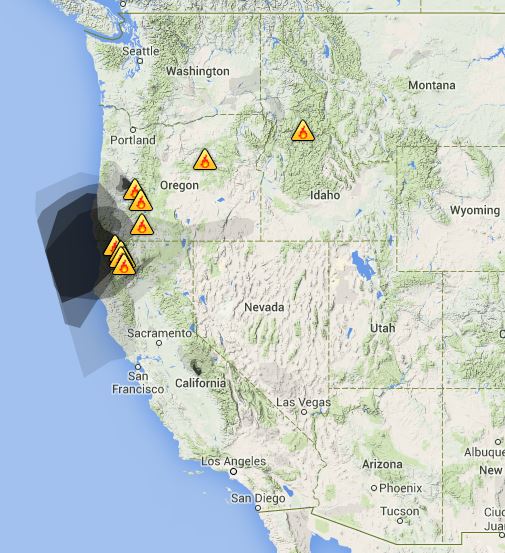
Smoke from the Happy Camp Complex of fires
Smoke from the Happy Camp Complex of fires in northwest California as seen from a satellite, September 5, 2014. The Smog Blog.

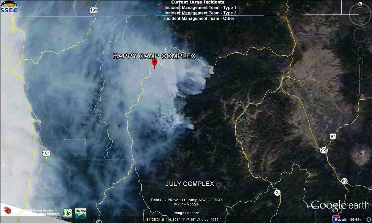
The Happy Camp Complex of fires in northwest California continued to expand on Friday, adding another 5,660 acres to bring the total up to 88,546 acres. The Incident Management Teams are calling it 25 percent contained. Another spot fire across the Klamath River and Highway 96 burned about two acres before it was knocked down north of the intersection of the highway and Scott River Road.

The Happy Camp area is infamous among wildland firefighters and locals for the inversions that trap smoke and keep it from dispersing. Some firefighters, after spending a couple of weeks in the polluted air, return home with respiratory problems that can linger for weeks or months.

wildfire Smoke map, Sept 6, 2014
Smoke map, Sept 6, 2014. Weatherunderground.
Smoke map, September 5, 2014. for northern California
Smoke map, September 5, 2014. for northern California. Source: California Smoke Information.

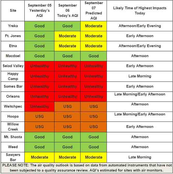
The air quality agencies recognize the problem, of course, but there is little they can do about it other than inform the public about how bad it is. The chart below warns that during the three day period five communities had or will have “unhealthy” air to breathe for at least one day: Seiad Valley, Happy Camp, Somes Bar, Orleans, and Weitchpec. Two others, Hoopa and Willow Creek, were in the “Unhealthy for Sensitive Groups (USG)” category.

Air quality forecast for northern California
Air quality forecast for northern California. “USG” means “Unhealthy for Sensitive Groups”. Source: California Smoke Information.

The California Smoke Information website had more details about the wildfire smoke conditions, posted on September 6, 2014:

Yesterday — Winds pushed smoke to the Southwest which impacted the communities of the lower Klamath, Salmon, and Trinity River drainages. Smoke pooled into the valleys at night and kept smoke concentrations high. The forecast change in wind direction was delayed and has yet to occur.

Today — Smoke is predicted to travel southwest down the Klamath and Salmon River drainages in the morning hours. By afternoon, smoke will change directions and head eastward to the Scott and Shasta Valleys. Smoke will pool in valleys and drainages overnight.

Tomorrow — Weather will be similar to the previous day. Smoke is forecast to pool into valleys and drainages with low dispersion. Communities to the west of the fires may experience improved conditions as an onshore flow pushes the smoke slightly westward.

To see the most current smoke reports on Wildfire Today, visit the articles tagged “smoke” at https://wildfiretoday.com/tag/smoke/

Happy Camp Fire Complex closing in on “megafire” status

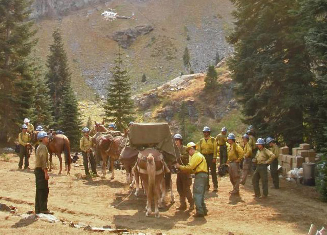
The Carson Hot Shots being resupplied by a mule team
The Carson Hot Shots being resupplied by pack animals on the Happy Camp Fire Complex. USFS photo by Mike McFadin.

The Happy Camp Complex of Fires west of Yreka, California is approaching what we have defined as “megafire” status — 100,000 acres of burned forest. As of Thursday night it has blackened 82,956 acres, a number that increases by 4,000 to 12,000 acres daily.

At a cost to date of $47.4 million, almost 3,000 people are assigned to the fire, along with 87 hand crews, 14 helicopters, 127 engines, 23 dozers, 43 water tenders, 29 mules, and 8 horses.

Some areas are still under an evacuation order.

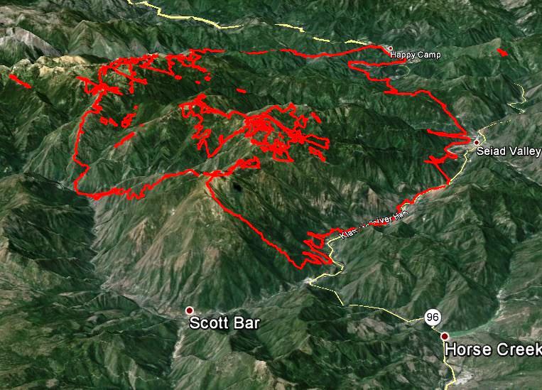
3-D Map of Happy Camp Fire
3-D map of the Happy Camp Complex Fire, looking west at 11 p.m. PDT, Sept 4, 2014.

Firefighters are hoping to keep the fire south of the Klamath River and Highway 96 between the communities of Happy Camp and Horse Creek, a goal they have mostly met, however there have been two large spot fires across the highway and the river that have been stopped. One of them was about 0.6 mile long and the other was about a tenth of a mile across.

On Thursday the fire was very active on the east side where it is burning downhill toward Scott River Road in the vicinity of Scott Bar (see the map of the fire above).

The area will remain under a Red Flag Warning through 11 p.m. Saturday due to a combination of strong winds and low relative humidity.

Photos by Kari Greer of the Happy Camp Complex

Happy Camp Complex, Klamath NF, CA, 2014

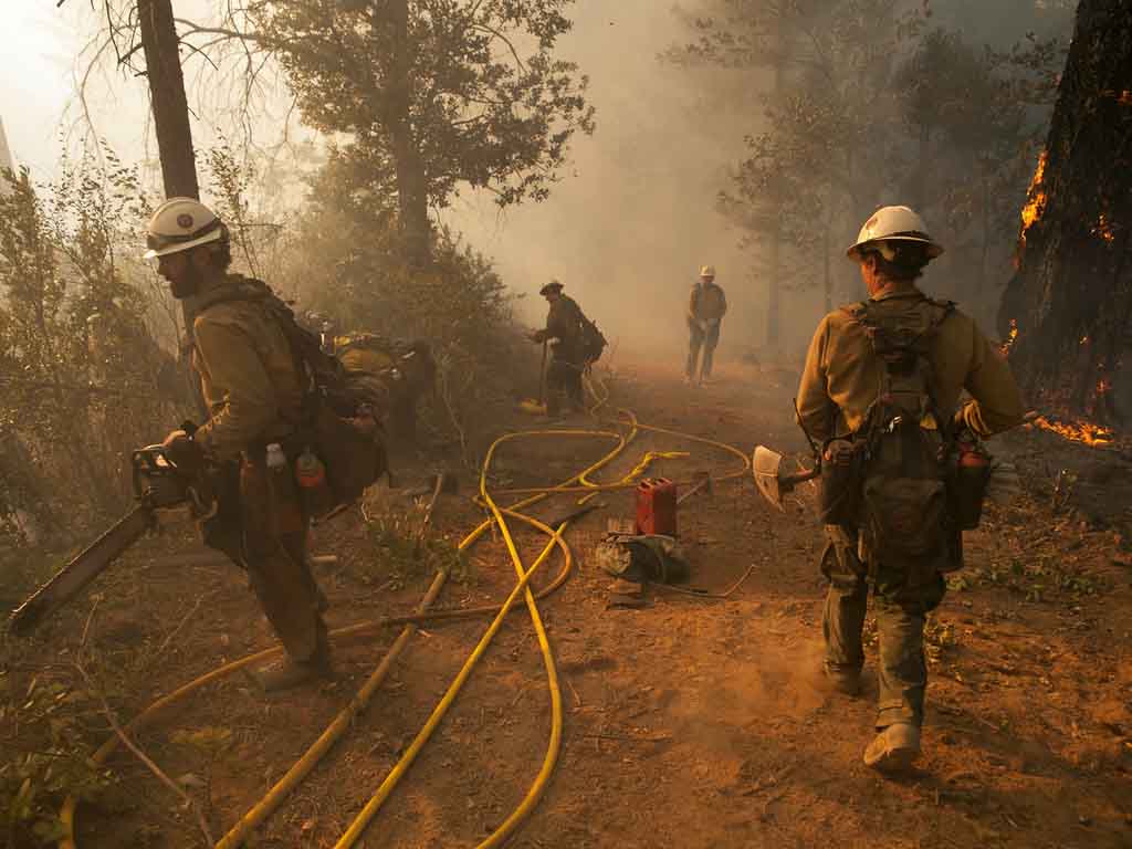
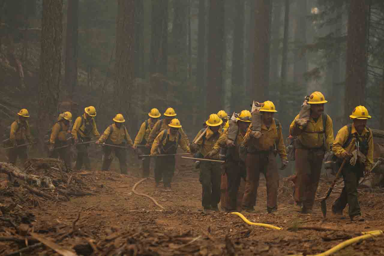
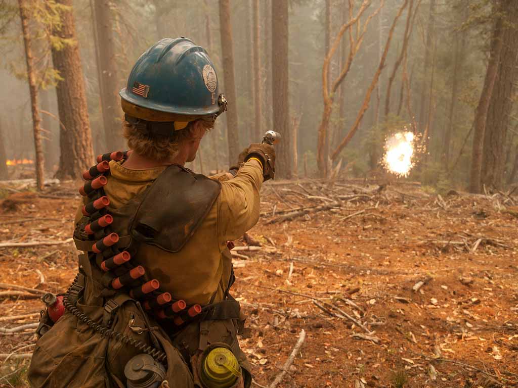
These photos of the Happy Camp Complex of fires were taken by Kari Greer for the U.S. Forest Service August 24 through 26. As you can see, she is one of the best fire photographers around. More of her work is available at Smugmug. Ms. Greer is under contract to the National Interagency Fire Center and carries a Red Card so that she can get right in the midst of the action. She left the Happy Camp Complex a few days ago, but just received a new order to return. At the 20-year commemoration of the South Canyon Fire in July, she found herself on the OTHER end of a camera lens.

The fire has burned about 77,000 acres in northwest California and is listed at 19 percent containment. It is being fought by 91 hand crews, 13 helicopters, 93 engines, 21 dozers, 44 water tenders, 29 mules, and 8 horses.Happy Camp Complex, Klamath NF, CA, 2014 Happy Camp Complex, Klamath NF, CA, 2014 Happy Camp Complex, Klamath NF, CA, 2014 Happy Camp Complex, Klamath NF, CA, 2014