Three firefighters entrapped and injured on the Likely Fire

Three firefighters on a crew in California suffered first and second degree burns on the Likely Fire northwest of Likely, California (map) on September 5. They were members of the CAL FIRE Devils Garden Crew 4 constructing fireline when a wind shift caused numerous spot fires. The firefighters attempted to retreat into a previously burned area when their escape route was blocked by a barbed wire fence. They received burns on their faces and were transported by a ground ambulance to a hospital where they were treated and released.

A Joint Accident Investigation Team comprised of BLM and CAL FIRE subject matter experts will be investigating the incident.

According to the criteria published by Ameriburn.org all facial burns should be treated at a burn unit, so we hope the firefighters received appropriate medical treatment and were not simply treated and released at the Modoc Medical Center in Alturas as stated in the 24-hour report.

Southern California brush fire in San Gabriel Canyon

Williams Fire, Sept 2, 2012
Williams Fire, Sept 2, 2012. Photo by 10 Tanker Air Carrier

The Williams Fire started in San Gabriel Canyon north of Azusa in southern California Sunday afternoon and through the afternoon and evening grew to 3,600 acres. The origin was between Camp Williams and the shooting range along East Fork Road in San Gabriel Canyon about 3.5 miles east of Highway 39. A map showing the location of the Williams fire is below.

Map of Williams Fire Sept 2, 2012. MODIS
Map of Williams Fire. The red circles represent the location of heat detected by a satellite. Sept. 2, 2012. MODIS (click to enlarge)

San Gabriel Canyon, which will be closed on Monday, Labor Day, typically sees over 10,000 visitors on a holiday weekend.

At least 300 personnel are assigned to the fire, as well as 9 air tankers, 4 helicopters, 30 engines, 2 dozers, and 4 hand crews. It is moving north through very steep terrain toward the Sheep Mountain Wilderness area. As of 2 a.m. Monday morning the fire was listed as 5 percent contained.

All of the photos below were taken by the crew on Air Tanker 911, a DC-10 which earlier on Sunday was repositioned from Casper, Wyoming where it had been based while working the fires in Nebraska, to Sacramento. From Sacramento it was dispatched to this fire, and Sunday night was at San Bernardino. The second DC-10, T-910, was recently released from their Call When Needed contract and sent home.

Williams Fire
Williams Fire, Sept 2, 2012. Photo by 10 Tanker Air Carrier

The LA Times has a nice collection of photos of the fire.

Engine burns on North Pass fire in northern California

North Pass fire
North Pass fire, as seen from Round Valley Airport. Undated InciWeb photo

An engine burned on the North Pass fire on the Mendocino National Forest on Saturday. The four crewpersons moved into a safety zone and were not injured. A facilitated learning analysis team has been requested.

One residence has been destroyed since Friday along with some outbuildings, bringing the total of burned structures to six. The fire has burned 26,648 acres and is 33 percent contained. Working on the fire are 1,534 personnel, 106 engines, and 65 dozers.

The fire is active on the northeast and east sides. The InciWeb report mentions extreme fire behavior and extreme terrain as some of the barriers they are attempting to overcome.


North Pass Fire smokes up Mendocino County

The North Pass Fire in Mendocino County gained acreage yesterday, and the fire is moving northeast into the Yolla Bolly Middle Eel Wilderness. Extreme fire behavior (crowning, torching, and long-range spotting) has been observed in the afternoons. The fire is 18 percent contained at 20,775 acres.
Northern California fires - satellite shotThere is no recorded fire history for the north side of the fire; both ERCs and live fuel moistures are at critical levels, with temperatures in the mid-90s. The Willits News reported that the fire is burning aggressively north and east. It crossed the Eel River on the southern border and is expanding in an easterly direction.

Smoke has been especially heavy in the Covelo/Round Valley areas, and air quality alerts have been issued.

The Lake County News reported that the fire is under unified command with Cal Fire and the U.S. Forest Service, and is burning in the Williams Valley area 10 miles northeast of Covelo. Two outbuildings were destroyed and 75 homes are threatened, along with five commercial properties and about 80 outbuildings.

Engines on the North Pass Fire

Mandatory evacuations are in effect for areas on Indian Dick Road and Mendocino Pass Road near Covelo, the Bauer Ranch subdivision, and nearby USFS campsites. There were nearly 1,100 personnel on the fire on Thursday evening, with 96 engines, 26 crews, two airtankers, six helicopters, 34 bulldozers, and 21 water tenders.

Ponderosa update

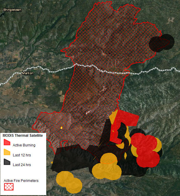
The L.A. Times reports that the Ponderosa Fire near Manton, California, is threatening nearly 1,000 homes; it’s 57 percent contained. The fire, about 30 miles east of Redding, has now burned more than 80 structures.

A Reuters report put the fire at nearly 28,000 acres, with 84 structures burned, including 64 homes. The report said that another 900 homes, 10 commercial properties, and 30 outbuildings are still threatened. Residents of the town of Mineral have been warned to be ready to evacuate.

ponderosa fire map
VESTRA / ESRI map

Evacuation orders have been issued for Manton and the area around the fire perimeter, and evacuation warnings have been issued for Mineral, Ponderosa Sky Ranch, and Lassen Lodge. anewscafe reported that some residents are returning to their homes and more areas north of the fire will be re-opened. Most of the utilities in the fire area have been restored and roads are being rehabbed. As many as 300 structures inside the fire area were saved.