River Fire burns thousands of acres near Colfax, Calif.

Evacuations are in effect

10:37 a.m. PDT August 5, 2021

River Fire map
River Fire map at 7:20 p.m. PDT Aug 4, 2021. The yellow areas represent intense heat when the fire was mapped.

Fire officials said in a briefing Wednesday evening that the River Fire west of Colfax, California had damaged or destroyed approximately 35 to 40 structures, but that number is preliminary and could change. Approximately 4,000 structures were threatened as of Wednesday evening.

The fire started at about 2 p.m. Wednesday and had spread for more than four miles when it was mapped at 7:20 p.m. that night. (see map above) Thursday morning CAL FIRE was calling it 2,400 acres.

The south end of the fire generally followed the Bear River drainage which comes out of Rollins Reservoir, then continued to the north-northeast as it spread to the Chicago Park area on Highway 174.

In an 8 p.m. briefing on Wednesday law enforcement officials said 2,400 people were under an evacuation order in Placer County. There were 4,200 under either evacuation orders or warnings in Nevada County.

The fire was pushed Wednesday afternoon by 5 to 8 mph winds gusting at 12 to 17 mph out of the south, southwest, and west while the humidity was in the teens and the temperature 95 degrees. The very dry fuels were receptive to burning embers that started numerous spot fires which burned together resulting in “area ignition”, as described in a briefing Wednesday evening.

Similar to Wednesday, on Thursday the Colfax area is surrounded by, but not officially within, a Red Flag Warning. The forecast for Thursday is for 85 degrees, 14 percent RH, and 8 to 10 mph southwest winds. On Friday it will be warmer (95 degrees) and drier with 9 mph winds out of the west.

Satellite photo, smoke from California fires
Satellite photo, smoke from California fires at 7:01 p.m. PDT Aug 4, 2021.

Dixie Fire spreads into Greenville, CA, burns structures

Threat is modified due to a change in wind direction

7:30 p.m. PDT, Aug 5, 2021

Dixie Fire map
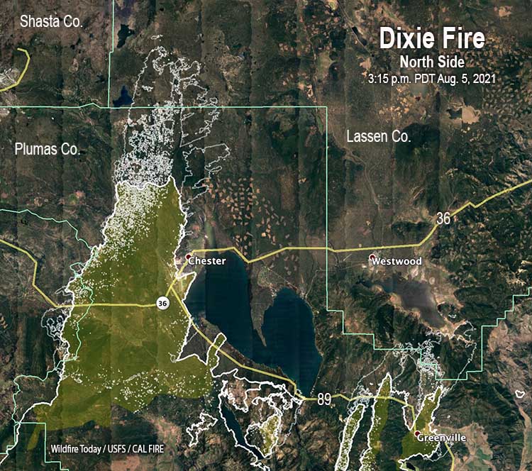
Dixie Fire map, north side, 3:15 p.m. PDT Aug 5, 2021. The yellow shaded areas represent extreme heat; however, not all areas with extreme heat are identified as such.

The spread of the Dixie Fire Thursday was made more complex and unpredictable by the passage of a weather trough. It hit the fire area in the afternoon and brought a significant change in the wind, shifting it from the south or southwest to come out of the west or west-northwest. This may not seem like a huge difference, but wind is the primary factor affecting the direction of spread of a vegetation fire. A 90-degree change in wind direction can turn the flank of a fire into the head. Next to the heel or back of a fire, the flank can sometimes be a somewhat safe place from which to attack a fire, unless it burning in extremely dry vegetation pushed by strong winds. (Which is often the case over the last several years.)

To see all articles on Wildfire Today about the Dixie Fire, including the most recent, click HERE.

Radar that was detecting smoke showed the wind shift in real time Thursday afternoon.

Firefighters who were on the right flank of the Dixie Fire today were no doubt warned by their Incident Meteorologist to expect the east flank Thursday afternoon to become the head of the fire, moving east quickly in their direction pushed by strong winds.

Westwood is a community of about 1,600 residents on Highway 36, 11 miles north of Greenville and 11 miles east of Chester. If the fire moves north from Greenville it will be threatened, and, if it moves east from Chester, it will be threatened.

By 3:15 p.m. Thursday the Dixie Fire, after destroying many of the structures in Greenville, had continued to spread 6 miles further north from the town. With long range spotting it reached Mountain Meadows Reservoir. If it finds a way around it, another 5 miles with a south or southwest wind and it could be at Westwood.

Another danger to Westwood is the northwest portion of the fire that burned over the Chester airport Wednesday and continued north during the night and Thursday, chewing through another 14 miles of forests. It looks like those 14 miles of the east flank could become a 14-mile wide head fire at least for a short time if the forecast pans out as expected.

The prediction for the Westwood area Thursday was for the winds to change direction in the afternoon to come out of the west at 13 mph with 21 mph gusts. The good news is the period of strong winds will be brief. At 8 p.m. it should decrease to 6 mph but still be from the west, and by 11 p.m. slow to 2 mph.

Obviously, Westwood is under a mandatory evacuation order by the Lassen County Sheriff’s office. (More information about evacuations.)

Keep the firefighters and the residents in your thoughts.

Continue reading “Dixie Fire spreads into Greenville, CA, burns structures”

Northern California wildfires visible from space

Satellite photo showing smoke from six large fires

5:55 p.m. PDT August 4, 2021

Satellite photo, fires in Northern California
Satellite photo, fires in Northern California, 4:21 p.m. PDT Aug 4, 2021.

Wednesday afternoon the GOES 17 satellite could easily photograph smoke from six large wildfires in Northern California:

  • Monument Fire, on the Shasta-Trinity NF was 15,000 acres Wednesday morning, ½ mile west of Big Bar along Highway 299 and east of Cedar Flat. It is threatening Big Bar, Del Loma, Big Flat, and Burnt Ranch.
  • McFarland Fire on the Shasta-Trinity NF Wednesday morning was 20,005 acres.  Evacuation orders are in place for the community of Wildwood.
  • River Complex on the Klamath NF consists of approximately 22 fires. Of these, 6 have been contained and are in patrol status. Of those that are active, most are ½ to 20 acres. The largest are Haypress at 5,500 acres, Cronan at 450 acres, and Summer at 2,500 acres, for a total of 8,487 acres.
  • Antelope Fire, approximately 2,400 acres, Klamath NF, was very active Wednesday afternoon with fire in the upper tree canopy. Spot fires have been observed 1/2 mile ahead of the main fire. Wednesday afternoon air resources could not assist firefighters on the ground due to poor visibility. It is moving north and impacting Tennant and Fish Camp.
  • Dixie Fire, on the Lassen NF, Plumas NF, and CAL FIRE. It was very active Tuesday night and Wednesday afternoon and has burned approximately 274,139 acres, threatening several communities, including Chester and Greenville. It has crossed Highway 89 in multiple locations and Wednesday morning was close to crossing Highway 36.
  • River Fire near Colfax, California about 40 miles northeast of Sacramento.

River Fire prompts evacuations near Colfax, CA

About 40 miles northeast of Sacramento

7:29 p.m. PDT August 4, 2021

River Fire map
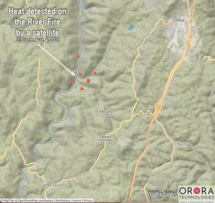
River Fire map, showing heat detected by a satellite at 2:30 p.m. PDT Aug 4, 2021, about half an hour after it was reported.

The map shows heat on the River Fire detected by a satellite at 2:30 p.m. PDT August 4, 2021.

CAL FIRE said that as of 7:25 p.m. Wednesday it had burned 1,400 acres.


6:16 p.m. PDT August 4, 2021

The River Fire in Placer and Nevada Counties 40 miles northeast of Sacramento was estimated at 1,000 acres at 5:45 Wednesday afternoon.

To see all articles on Wildfire Today about the River Fire, including the most recent, click HERE.

This is a dangerous fire and is spreading very rapidly to the north and northeast. Residents that feel uncomfortable should not wait for an evacuation order  — officials may not have time to make all of the necessary notifications during this very dynamic event.

From the Placer County Sheriff’s Office (time uncertain, but it was found on the Sheriff’s Facebook page at 6:12 p.m. local time)

     **Colfax area EVACUATION Order**
Fire crews are battling a fire near Colfax. There is an EVACUATION ORDER in place for the town of Colfax and the area starting at the Bear River Campground and extending on both sides of Milk Ranch Road to Tokyana Road; West of the railroad tracks to the river; From Mt Howell Rd north to Rollins lake. Gather your essentials and leave the area safely.
Residences that have been evacuated can go to the Auburn Veterans Memorial Hall at 100 East Street in Auburn.
** A secondary evacuation site is yet to be determined**


4:22 p.m. PDT August 4, 2021

River Fire
River Fire, looking east-southeast from Wolf Mtn at 4:16 p.m. PDT Aug 4, 2021.

Updated at 4:07 p.m. PDT August 4, 2021

River Fire
River Fire as seen from the Howell Mtn camera, looking north at 3:25 p.m. PDT Aug 4, 2021.

A fire that broke out Wednesday afternoon near Colfax, California is already prompting evacuations. The River Fire reported near the Bear River Campground is burning west of Interstate 80 on both sides of the Bear River in both Placer and Nevada Counties.

Colfax is on Interstate 80 about 40 air miles northeast of Sacramento.

At 3:40 p.m. CAL FIRE reported it had burned approximately 100 acres and is north of Applegate.

At least two helicopters, six air tankers, and one very large air tanker have been working the fire, reloading at Grass Valley and Sacramento McClellan.

The Placer County Sheriff’s Office ordered an evacuation for the area starting at the Bear River Campground and extending on both sides of Milk Ranch Road to Tokyana Road, Moorhaven Way, Placer Hills Road, Ben Taylor Road and Hillcrest Boulevard.

The fire is very close to but not within locations covered by a Red Flag Warning Wednesday and Thursday. At 3:50 p.m Wednesday the nearby PG377 weather station on Dog Ranch Road recorded 93 degrees, 17 percent RH, and 7 mph winds out of the southwest gusting to 16 mph. The forecast for Wednesday night is for the wind direction to shift to the southeast and the RH to increase to 35 percent. On Thursday it will be cooler, 85 degrees, with 15 percent RH and 6 to 10 mph winds out of the south and southwest.

Dixie Fire spreads north, Sheriff orders evacuation of Chester, CA

Very significant destruction of structures in Greenville, California Wednesday afternoon

7:13 p.m. PDT August 4, 2021

Reporters in Greenville, California have documented what one of them calls “widespread destruction” after the Dixie Fire ran through the town Wednesday. Much of the damage occurred around 5 p.m.

One scanner report said some law enforcement and fire personnel had to evacuate the area for their own safety.

To see all articles on Wildfire Today about the Dixie Fire, including the most recent, click HERE.

Dixie Fire damages structures in Greenville, CA


2:57 p.m. PDT August 4, 2021

Dixie Fire at 2:54 p.m. PDT Aug 4, 2021
Dixie Fire at 2:54 p.m. PDT Aug 4, 2021.

Above: the Dixie Fire seen from four cameras at 2:54 p.m. PDT August 4, 2021.


7:53 a.m. PDT August 4, 2021

Map of the Dixie Fire at 7 a.m. PDT Aug 4, 2021
Map of the Dixie Fire at 7 a.m. PDT Aug 4, 2021. The red areas indicate intense heat from the fire.

The Dixie Fire was very active throughout Tuesday night, with most of the movement during the night occurring on the northwest side. During a mapping flight at 7 a.m. Wednesday two large fingers of fire spread north to within less than a mile of Highway 89. At that time there was a small spot fire three-quarters of a mile north of the highway, more than a mile out in front of the main fire.

Continue reading “Dixie Fire spreads north, Sheriff orders evacuation of Chester, CA”

Multiple fires in Northwest California have broken out in recent days

Many fires started from lightning July 29

wildfires in Northwest California map
Satellite photo showing heat and smoke from wildfires in Northwest California at 2:56 a.m. PDT August 2, 2021.

Lightning-caused fires, many of which started July 29, are starting to cover large portions of Northwest California with smoke. Monday afternoon the GOES 17 satellite in geosynchronous orbit 22,300 miles above the Earth could easily detect the heat from four large fires in the extreme northwest corner of the state, as well as their extensive smoke plumes.

The fact that the River Complex of fires on the Klamath National Forest is comprised of 19 fires at last count, can give you an idea what might be out there on that forest as well as the nearby Six Rivers and Shasta-Trinity National Forests. Monday afternoon the Siskiyou County Sheriff’s Office ordered evacuations for Taylor Creek Road and surrounding areas. Some of the larger fires in the complex include, Haypress, 600 acres; Summer, 75 acres; Cronan, 165 acres; and Packers, 50 acres.

wildfires in Northwest California map
Map showing heat detected on wildfires in Northwest California by satellites at 12:55 a.m. PDT August 2, 2021.

Two large fires are already well established on the Shasta-T, the McFarland and Monument Fires. Today, Monday, two or three other fires further north show up on the satellite photo.

I picked a random location for a weather forecast, 18 miles ESE of Orleans, CA and found that the conditions through Sunday August 8 will be conducive to continued fire spread with the relative humidity in the teens or low twenties, moderate wind speeds, and no chance of precipitation.

Energy Release Component Hayfork, California, Aug. 1, 2021
Energy Release Component Hayfork, California, Aug. 1, 2021.

Since the middle of May the Energy Release Component at Hayfork has been hovering above or below the highest levels ever recorded at that site. The ERC is an index related to how hot a fire could burn. Extremely dry vegetation is one of the factors that can lead to high ERC levels.

With over 22,000 personnel already tied up on 72 un-contained wildfires in the country it may not be easy to staff many additional large fires.

The US Forest Service has already exhausted the list of large air tankers that are available on USFS call when needed contracts — it turned out to only be five, instead of the 16 or more the Forest Service described earlier this year. The only ones left are three military C-130’s with slip-in Modular Airborne FireFighting Systems, which for some reason have not been activated.