Light rain observed on parts of the Mosquito Fire

The fire 35 miles northeast of Sacramento was very active Sunday, spreading east up to a mile

3 p.m. September 12, 2022

Mosquito Fire map
Mosquito Fire map. The red line was the perimeter at 1:19 p.m. PDT Sept. 12, 2022. The white line was the perimeter on the morning of September 11, 2022. Three previous fire footprints are also shown.

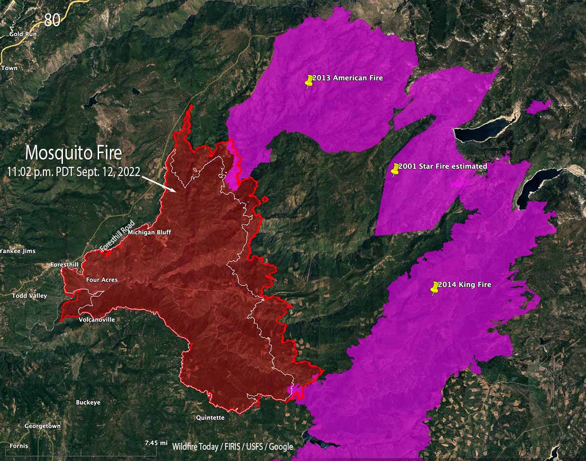
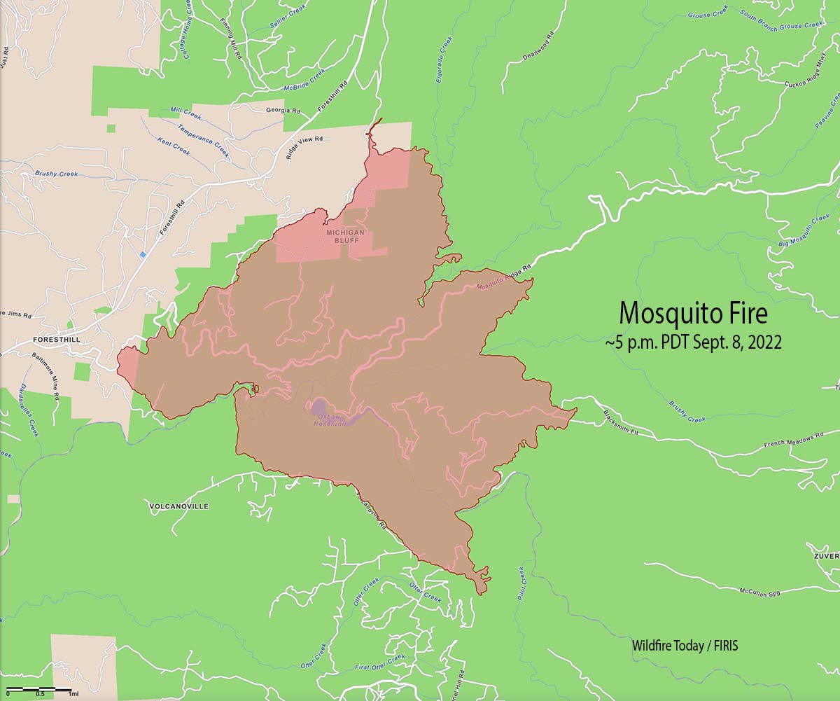
On Sunday the east side of the Mosquito Fire spread as much as a mile to the east. Having already burned through most of the footprint from the 2007 Ralston Fire, for the first time it moved into the 2013 American Fire and the 2014 King Fire. It did not burn enough of those two more recent fires to get a good picture of how likely it is to spread completely through those eight and nine year old footprints.

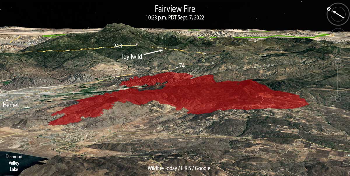
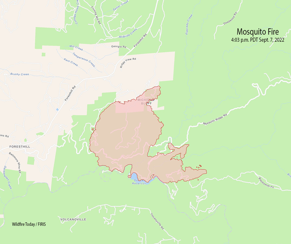
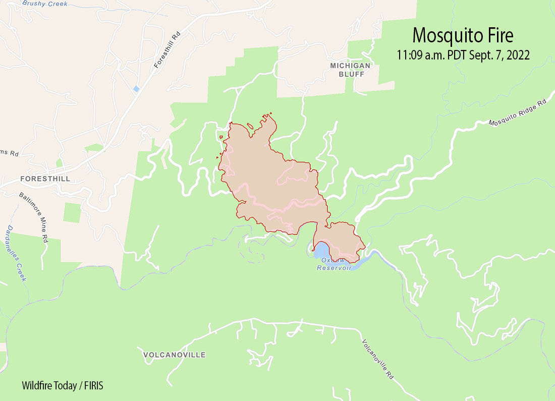
At 1:19 p.m. Monday it was mapped by a fixed wing aircraft at about 48,500 acres. The blaze is 35 miles northeast of Sacramento.

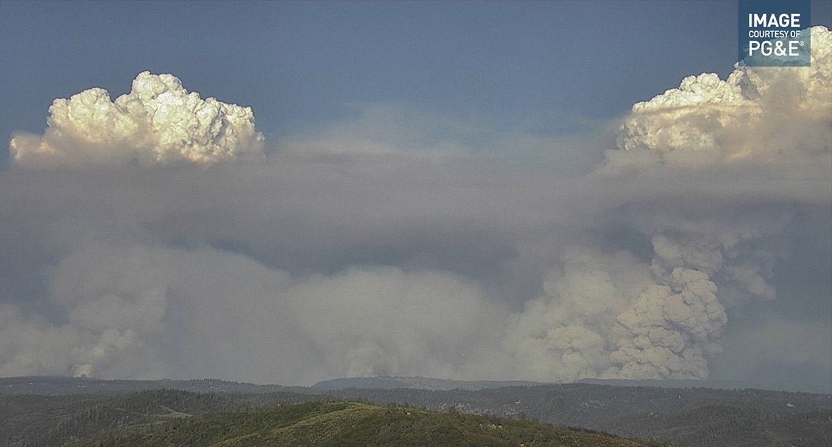
Monday afternoon satellite and ground based cameras showed clouds, haze or smoke, and scattered thunderstorms in the general area of the fire. Light showers were reported in some areas. If strong outflow winds from passing thunderstorms hit the fire area without any rain it could increase the rate of spread significantly, sometimes in unexpected directions.

Crews working Sunday night on the southwest side between Foresthill and Volcanoville had to stop a strategic firing operation due to a small amount of rain. If conditions permit they hope to continue the operation today.

The weather forecast for Monday through Wednesday is for light to moderate winds of 2 to 9 mph generally from the southwest during the day  with minimum humidities in the 30s and 40s. Thursday through Saturday the winds will be very light while the humidity will be in the 40s.

In the video below watch how smoke from the Mosquito Fire overtakes Reno, Nevada.

Rain from tropical storm Kay slows spread of Southern California fires

Precipitation, vicinity of Fairview Fire,
Precipitation, vicinity of Fairview Fire, 24 hours ending 5 a.m. Sept. 10, 2022

Rain that began falling at about 1 p.m. Friday slowed the spread of the Fairview and Radford Fires in Southern California. By 5 a.m. Saturday weather stations near the fires had recorded amounts ranging from 0.05″ to 0.28″.  Much higher amounts were found at a few locations in the mountains east of the Fairview Fire.

The precipitation is expected to continue into Sunday morning.

Precipitation, vicinity of Radford Fire,
Precipitation, vicinity of Radford Fire, 24 hours ending 5 a.m. Sept. 10, 2022
Fairview Fire map Sept. 10, 2022

There was a concern that very strong winds generated by tropical storm Kay would cause problems at the fires, but those did not materialize, at least not by 5 a.m. Saturday.

Precipitation, Southern California, 24 hours ending 5 a.m. Sept. 10, 2022

As of 5 a.m. the rain had occurred as far north as Santa Barbara and Edwards Air Force Base. It did not affect the rapidly growing Mosquito Fire 27 miles west of Lake Tahoe, CA.

Meanwhile, Red Flag Warnings are in effect Saturday for the northwest corner of California and the west sides of Washington and Oregon.

Red Flag Warnings September 10, 2022

The forecast for vertically integrated wildfire smoke predicts impacts in most of the Western States Saturday afternoon.

Forecast for smoke
Forecast for smoke at 1 p.m. MDT Sept. 10, 2022. NOAA

Firefighters working to save structures in the Mosquito Fire in Northern California

It has burned tens of thousands of acres near the community of Foresthill

Updated 9:41 a.m. PDT Sept. 10, 2022

Mosquito Fire map 11:45 p.m. PDT Sept. 9, 2022
Mosquito Fire map 11:45 p.m. PDT Sept. 9, 2022. The white line was the perimeter about 24 hours before. The orange areas represent intense heat.

The Mosquito Fire at Foresthill in Northern California was very active again Friday, but did not spread as much as in recent days. That was due to the overnight and morning inversion layer dissipating later than usual and very little wind, ranging from calm to three mph Friday and Friday night. The temperature was 93 degrees and the minimum relative humidity was 21 percent.

The forecast for Saturday is 88 degrees, afternoon winds out of the southwest at 8 mph, 50 percent cloud cover, and 27 percent relative humidity. Sunday should be about the same.

Despite the moderate weather conditions, on Friday there was incremental growth on most of the perimeter except for along Foresthill Road and the area 1 to 5 miles east of Volcanoville. At its widest point the fire is 12 miles long.

The fire was mapped Friday night at 33,753 acres.

The Incident Management Team plans to provide structure defense and point protection for values at risk and protect private timberlands.

The map below shows fires in the National Interagency Fire Center database that have occurred in the area since 1990. It appears possible that under extreme weather and fuel conditions the fire could spread significantly to the east or northeast. The Mosquito Fire about 6 miles from the 2014 King Fire and 28 miles from Lake Tahoe.

Mosquito Fire, area history
History of fires in the Mosquito Fire area, 1990 to 2021. NIFC / Wildfire Today.

11:55 a.m. PDT Sept. 9, 2022

Mosquito Fire map 11:04 a.m. PDT Sept. 9, 2022
Mosquito Fire map 11:04 a.m. PDT Sept. 9, 2022.

Firefighters have been working hard to save structures in the Foresthill area as the Mosquito Fire grows larger. Early unofficial reports say they were successful.

Most of the movement is to the east and southeast, but it has also been spreading west into the community of Foresthill and has moved into El Dorado County. It was mapped at about 11 a.m. Friday at 29,585 acres.  Friday morning the area is thick with heavy smoke, preventing tactical aircraft from flying.

Cameras were able to provide images of the fire into Thursday night until smoke obscured the view.

Mosquito Fire
Mosquito Fire, looking northeast from the Bald Mtn Eldorado camera at 1:28 a.m. Sept 9, 2022.

Fire officials are aware of damage to structures in the Michigan Bluff area, and possibly other locations, and will survey the effects when it can be done safely.

The status of evacuations has changed. Placer County has a map showing evacuation orders and warnings. El Dorado County also has a map.

The blaze exhibited extreme fire behavior Thursday, forming huge rotating convection columns.

Spread of the Radford Fire at Big Bear slows in Southern California

Rain is expected to begin Friday afternoon

9:45 a.m. PDT September 8, 2022

Radford Fire 3-D map
Radford Fire 3-D map, looking west at about 11 p.m. September 7, 2022.

The spread of the Radford Fire just south of Big Bear in Southern California slowed Wednesday night and Thursday morning as the wind slowed to a calm in some areas and the relative humidity rose to 50 to 70 percent depending on the location on the mountain. With the change in the weather, Thursday morning the fire is burning in the understory with only limited torching or uphill runs.

That could change Thursday afternoon as the influence of Hurricane Kay increasingly affects the area. The wind is expected to increase to 14 mph out of the southwest gusting to 22 while the relative humidity drops into the 30s. Winds should be much more subdued overnight but on Friday will increase by 4 p.m. to 25 mph gusting out of the east-southeast up to 39 mph with RH in the 30s and 40s. Beginning at 11 a.m. on Friday the chance of rain jumps to 60 percent with the RH rising to 80 percent. Precipitation amounts through Friday night could be more than 0.6″ of an inch. The rain could continue into Saturday night or Sunday morning.

Radford Fire map
Radford Fire map at about 11 p.m. September 7, 2022.

A mapping flight at around 11 p.m Wednesday found that the Radford Fire had burned about 1,100 acres. The fire, moving uphill to the north, crested the ridge above the two skiing areas and spread down hill toward Big Bear a short distance between the two areas.


Fairview Fire grows to the south and east

In Southern California near Hemet

Updated 10:24 a.m. PDT Sept. 9, 2022

Fairview Fire map
Fairview Fire map. The red line was the perimeter at 4:55 a.m. PDT Sept 9, 2022. The white line was the estimated perimeter at 10:23 p.m. Sept. 7.

Thursday night firefighters assisted by night-flying helicopters were dealing with flare ups on the west and northwest side of the Fairview Fire. There was a report of structures burning near Mento Way.

Rain is in the forecast for the Fairview Fire, beginning Friday morning with showers followed by more steady rain in the afternoon and evening. The minimum relative humidity Friday will be 54 percent. East winds at 13 to 25 mph will increase to 26 to 29 mph in the afternoon. Thunderstorms are possible at any time with lightning, gusty erratic winds, and heavy rain. Strong winds are expected to decrease Saturday, with showers continuing.


10:46 a.m. PDT September 8, 2022

Fairview Fire map, 10:23 p.m. Sept 7, 2022
Fairview Fire map, 10:23 p.m. Sept 7, 2022.

The Fairview Fire southeast of Hemet, California was extremely active Wednesday night, exhibiting extreme fire behavior resulting in fire officials requesting an additional 25 engines. It pushed strongly to the south and to the east as it doubled in size in about six hours, growing to 19,377 acres. (see map above)

Evacuation areas have been expanded. More information.

Fairview Fire 3-D map
Fairview Fire 3-D map, looking northeast at 10:23 p.m. Sept 7, 2022.

When the fire was mapped Wednesday at 10:23 p.m. it had spread south across Red Mountain Road, Oak Glen Road, and Timber Trail. At that time it was about three miles northeast of the community of Sage and was still east of Sage Road.

Fairview Fire
The Fairview Fire was very active September 8 at 3:41 a.m., as seen looking WSW from the Idyllwild camera.

The east side continued growing east across Bautista Road and when last mapped had reached Forest Road 5S15 about a mile from Highway 74.

Three large helicopters from the Quick Reaction Force worked the fire during the night, dropping retardant aided by their intelligence gathering helicopter.

The spot weather forecast issued Wednesday at 5:27 p.m. predicts for the fire area on Thursday 94 to 100 degrees, 21 percent relative humidity, and winds out of the west at 4 mph. There is a small chance for wetting rains Friday afternoon which will increase to about 40 percent by late Saturday morning.

The photos below were taken by Ryan Grothe September 7 at the Fairview Fire.

Fairview Fire, Sept. 7, 2022
Fairview Fire, Sept. 7, 2022. By Ryan Grothe.
Fairview Fire, Sept. 7, 2022
Fairview Fire, Sept. 7, 2022. By Ryan Grothe.
Fairview Fire, Sept. 7, 2022
Fairview Fire, Sept. 7, 2022. By Ryan Grothe.
Fairview Fire, Sept. 7, 2022
Fairview Fire, Sept. 7, 2022. By Ryan Grothe.

Mosquito Fire prompts evacuations near Foresthill, California

Updated 6:50 p.m. PDT September 8, 2022

Mosquito Fire map
Mosquito Fire map at about 5 p.m. Sept. 8, 2022.

The Mosquito Fire east of Foresthill, California made an impressive run Thursday afternoon, growing from 8,265 acres at 1:30pm to 13,705 acres at 5pm — an increase of 5,440 acres in about 3.5 hours. Most of the growth was on the east half of the fire but the west side spread closer to Foresthill.

At times the rapidly expanding fire was putting up multiple convection columns topped by pyrocumulus clouds.

Mosquito Fire
Mosquito Fire as seen looking ENE from the Auburn camera at 5:32 p.m. Sept. 8, 2022.

The number of areas under evacuation orders has increased. The Placer County Sheriff’s Office has produced a map with the details. You can follow the Sheriff on Facebook and Twitter for evacuation updates.
https://www.facebook.com/PlacerSheriff
https://twitter.com/PlacerSheriff

On Thursday structures were being threatened in Volcanoville and Foresthill.

Mosquito Fire satellite photo
The Goes 17 satellite detected heat and smoke from the Mosquito Fire at 606 p.m. PDT Sept 8, 2022.

On Thursday afternoon the temperature topped out at 101 degrees in Foresthill, the relative humidity dropped to 15 percent, and the wind was only 2 to 5 mph mostly out of the west. The forecast for Friday calls for 102 degrees, 15 percent RH, and winds out of the east and northeast around 5 mph shifting to the west/southwest at 6 to 12 mph in the afternoon with gusts up to 20 mph.


Updated 7:43 p.m. PDT September 7, 2022

Mosquito Fire map 4:03 p.m. Sept 7, 2022
Mosquito Fire map 4:03 p.m. Sept 7, 2022.

Wednesday afternoon the Mosquito Fire east of Foresthill, California spread significantly north and east. On the north side it moved into the Michigan Bluff area, while on the east side it spread beyond Gorman Ranch Road, along Mosquito Ridge Road, and across Blacksmith Fit.

Mosquito Fire 6:35 p.m. PDT Sept. 7, 2022
Mosquito Fire as seen from Bald Mtn Eldorado camera looking north at 6:35 p.m. PDT Sept. 7, 2022.

At about 4 p.m. the FIRIS aircraft mapped it at 4,223 acres, an increase of approximately 3,000 acres since 11 a.m.

Evacuation information is below.


3:23 p.m. PDT September 7, 2022

Mosquito Fire map
Mosquito Fire map 11:09 a.m. Sept 7, 2022.

Evacuations have been ordered for the Mosquito Fire in the Foresthill area of Northern California, 17 miles northeast of Auburn.

Wednesday morning the fire was about a mile east of Foresthill, and was burning very actively during the afternoon. The estimated size at about 11 a.m. was 1,220 acres.

Most of the fire is within the boundaries of the Tahoe National Forest. It was reported at about 6:27 p.m. Tuesday September 6.

The Placer County Sheriff’s Office has ordered evacuations. They produced a map with the details.

You can follow Placer County Sheriff on Facebook and Twitter for evacuation updates.
https://www.facebook.com/PlacerSheriff
https://twitter.com/PlacerSheriff

Mosquito Fire
Mosquito Fire as seen from Bald Mtn Eldorado camera looking NNW at 1:59 p.m. PDT Sept. 7, 2022.