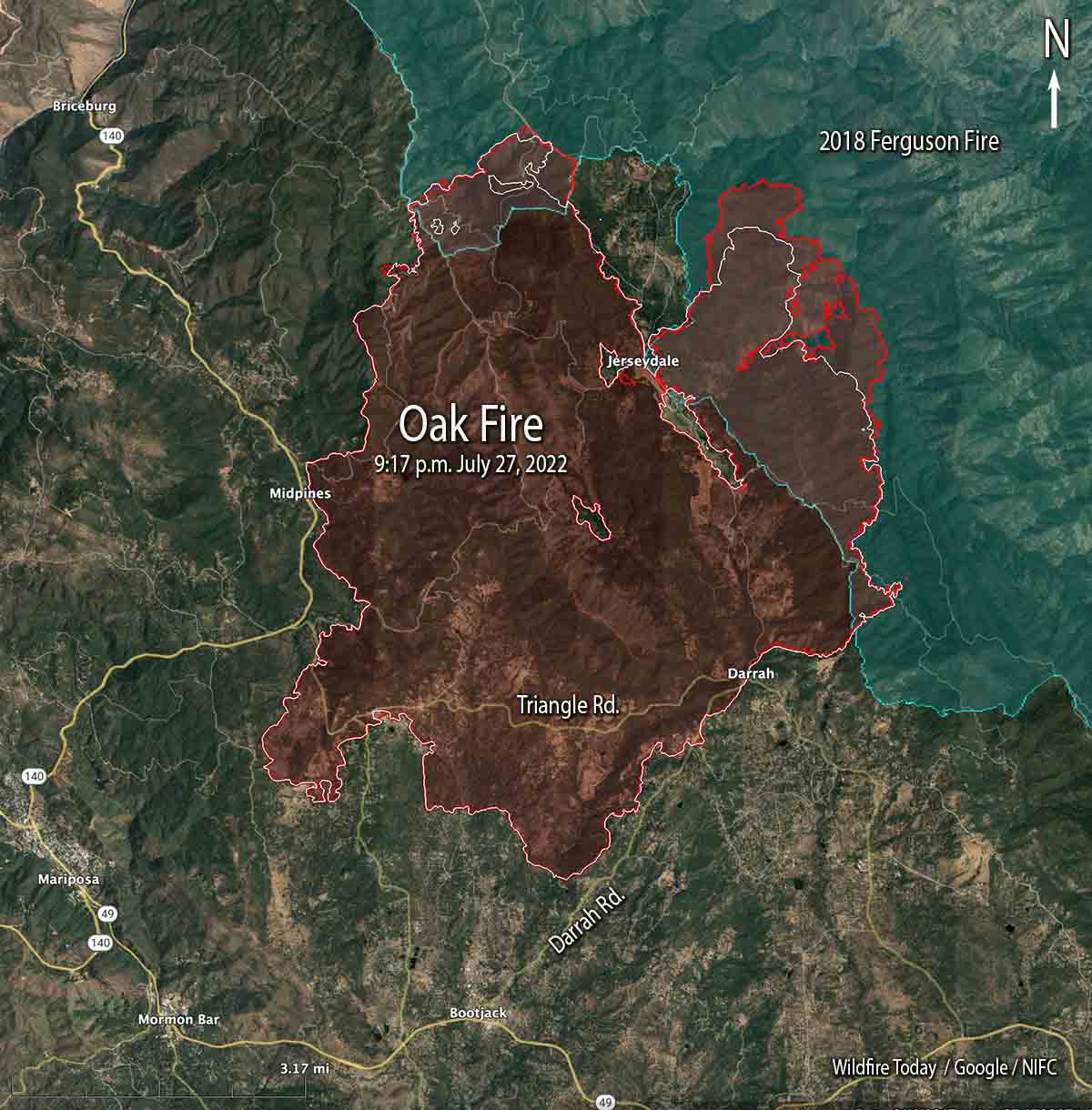
Oak Fire map. The red line was the perimeter at 9:17 p.m. July 27, 2022. The white line was the perimeter about 48 hours before.
Most of the perimeter of the Oak Fire northeast of Mariposa, California was quiet on Wednesday, with the exception of the north and northeast sides where it has continued to spread. Firefighters have constructed firelines in those areas, some of them indirect, and are making progress. It has moved one to two miles into the footprint of the 2018 Ferguson Fire.
To see all articles on Wildfire Today about the Oak Fire, including the most recent, click HERE.
The fire was mapped Wednesday night at 19,169 acres.
The video below was shot by the FIRIS aircraft looking south at the northeast side of the fire at 9:20 p.m. July 27. White indicates heat.
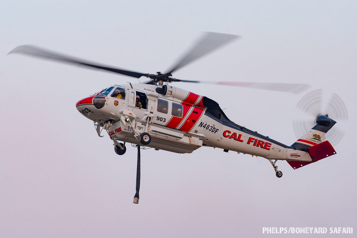
CAL FIRE is using one of their new Firehawk helicopters to drop water at night
7:05 a.m. PDT July 26, 2022
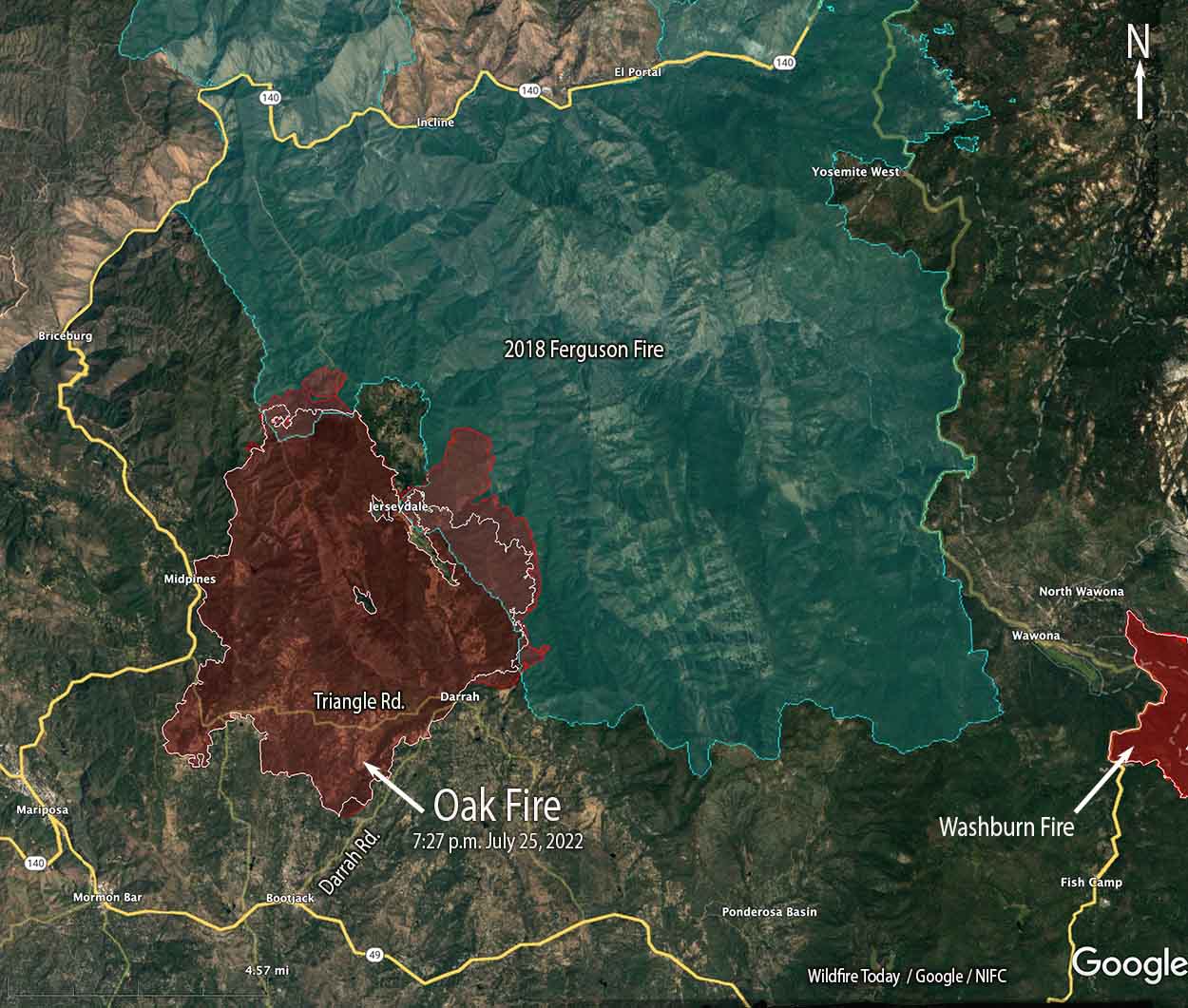
Oak Fire map. The red line was the perimeter at 7:27 p.m. July 25, 2022. The white line was the perimeter about 23 hours before.
Fire officials called Monday a successful day on the Oak Fire northwest of Mariposa, California, saying there was minimal growth. The 1,200 acres added paled in comparison to the rapid spread seen on Friday and Saturday. It was mapped Monday night at 18,017 acres, with most of the increase being on the east side where it is chewing through the four-year old vegetation in the footprint of the 2018 Ferguson Fire. East of Jerseydale it has advanced nearly two miles into the fire scar.
To see all articles on Wildfire Today about the Oak Fire, including the most recent, click HERE.
Helicopters dropped 300,000 gallons of water Monday, including thousands of gallons dropped by one of CAL FIRE’s new night-flying helicopters, H-903, normally based at McClellan near Sacramento. According to tracking data recorded by FlightAware it conducted what appeared to be two fuel cycles working out of the Columbia airport 42 miles northwest of the Oak Fire. Until CAL FIRE recently purchased their 12 new Sikorsky S-70i Firehawk helicopters they were not in the night-flying business. This was one of the first fires CAL FIRE has flown at night.
CAL FIRE H-903, Sikorsky S-70i FireHawk, N483DF, Photo by Dylan Phelps, Sept. 2020.
The damage assessment team has been working for the last two days to identify structures affected by the fire. Monday afternoon their findings to date were released — 21 residences and 34 outbuildings have been destroyed.
Resources on the incident Monday night included 24 helicopters, 302 fire engines, 82 dozers, 68 water tenders, and 61 hand crews for a total of 2,991 personnel.
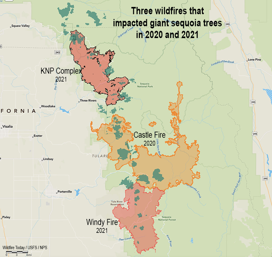
Three fires in two years that killed giant sequoia trees. The darker green areas represent groves of giant sequoias.
The U.S. Forest Service distributed information yesterday saying there are areas still burning in giant sequoia groves after wildfires that occurred in the Castle and Windy Fires of 2020 and 2021.
From the Sequoia National Forest, July 23, 2022:
Three fires were discovered this week, still smoldering inside the 2020 Castle and 2021 Windy Fires. Firefighters from Sequoia National Forest quickly reached two, and the third could not be reached safely due to the dense stand of fire-killed trees surrounding it.
The 1-acre Cougar Fire was found burning in the Red Hill Giant Sequoia Grove near the Tule River Indian Reservation boundary. Less than a half mile away, the ¼-acre Crawford Fire was reported by fire personnel responding to the Cougar Fire. Both were caused by a smoldering giant sequoia tree leftover from last summer’s Windy Fire.
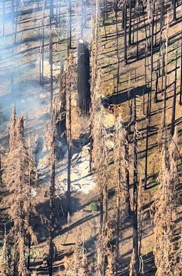
Burning area in giant sequoia grove. US Forest Service. Photo distributed July 23, 2022. (Date of the photo and name of fire not provided)
Fireline was constructed by hand to stop each fire from spreading further. Heavy material: treetops, limbs, and trunks of previous fallen trees continue to smolder underneath these still-standing sequoia trees, weakened by the fire burning inside them. Fire personnel will continue to mop up and extinguish what they can without jeopardizing their safety by having to work under a burning giant sequoia tree. Neither the Cougar nor Crawford Fires pose an immediate risk to nearby communities.
On Thursday, a third fire was reported southeast of Camp Nelson in the Belknap Giant Sequoia Grove. Helicopter personnel located this fire deep inside the burned area of the 2020 Castle Fire. Due to its remote location, numerous standing hazard trees endangering fire personnel, and minimal chance of escape, this fire will be monitored from a distance and by air.
There have been several instances of smoldering trees, most of them large diameter giant sequoias, observed and reported in both the Castle and Windy Fire burned areas. These are likely to continue as dry conditions persist. Firefighter safety is a priority when determining how best to extinguish these types of fires. They may have to be monitored until the trees fall on their own and can be managed safely on the ground.
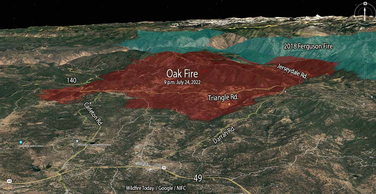
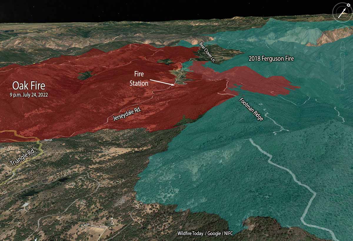
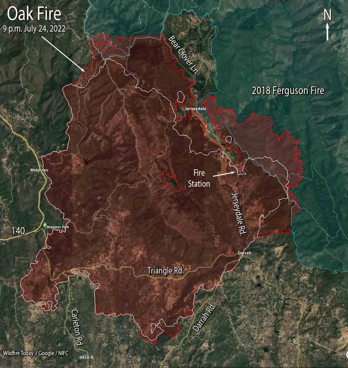
Oak Fire 3-D map, looking north at 9 p.m. July 24, 2022.
The Oak Fire northeast of Mariposa, California was very active Sunday especially on the east side where firefighters worked to minimize the spread beyond Footman Ridge and battled, successfully, to keep it from crossing Bear Clover Lane.
The blaze was mapped Sunday night at 16,791 acres.
To see all articles on Wildfire Today about the Oak Fire, including the most recent, click HERE.
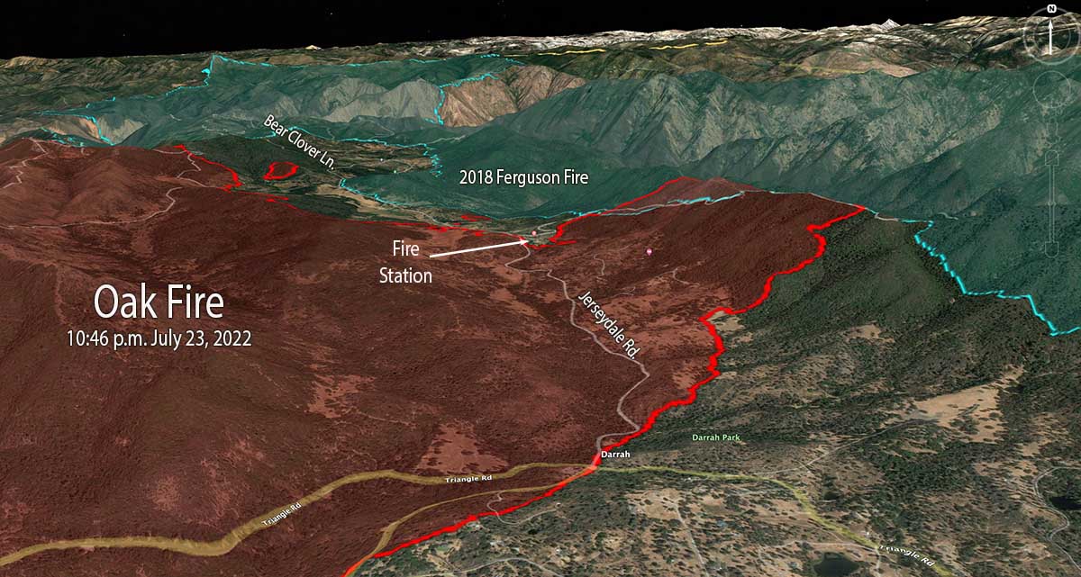
Part of the western edge of the Ferguson Fire that burned 96,000 acres in 2018 was south of Jerseydale and east of Jerseydale Road. That four-year-old footprint is not stopping the Oak Fire, but the rate of spread and intensity is greatly diminished as it burns, giving firefighters more options to put in direct fireline on the edge where they can, and construct indirect lines out ahead. Drops from helicopters and air tankers are also more effective in the lighter fuels.
Oak Fire 3-D map, east side, looking northwest at 9 p.m. July 24, 2022.
While personnel have their hands full slowing or stopping the spread on the east and north sides, the south and west perimeters are looking much better. Direct fire line has been completed in many areas and tactical burning has helped to secure the edge.
In a community meeting Sunday evening fire officials said that soon after the fire started at 2:10 p.m. Friday it was creating spot fires two miles ahead of the main fire. At that time there was little the limited number of firefighters at the scene could do other than protect lives and structures and help with evacuations.
Oak Fire map. The red line was the perimeter at approximately 9 p.m. July 24, 2022. The white line was the perimeter about 23 hours before.
The number of structures reported as having been destroyed remains at 10, but that number will change after the two-person damage assessment team begins to report their findings, which may be released today.
Resources on the incident include 17 helicopters, 225 fire engines, 58 dozers, 23 water tenders, and 51 hand crews for a total of 2,093 personnel.
Oak Fire, looking northwest from Miami Peak at 7:18 a.m. July 25, 2022.
The video below has excellent footage of air tankers dropping retardant on the Oak Fire. You’ll see in order, DC-10 with a lead plane, BAe-146, DC-10 making a downhill drop, and finally an S-2T.
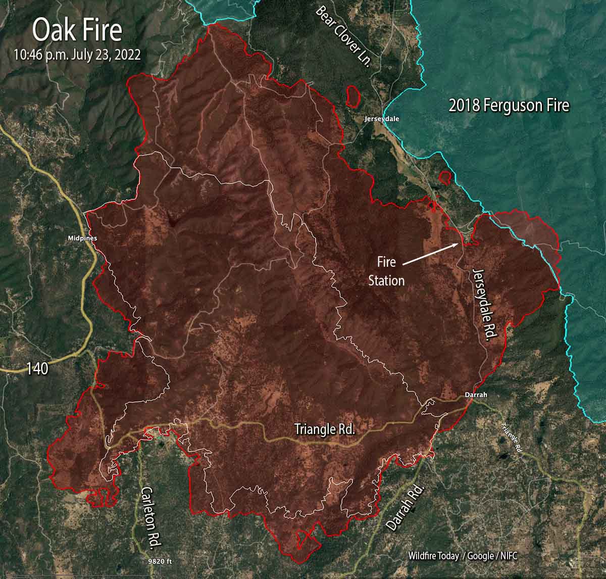
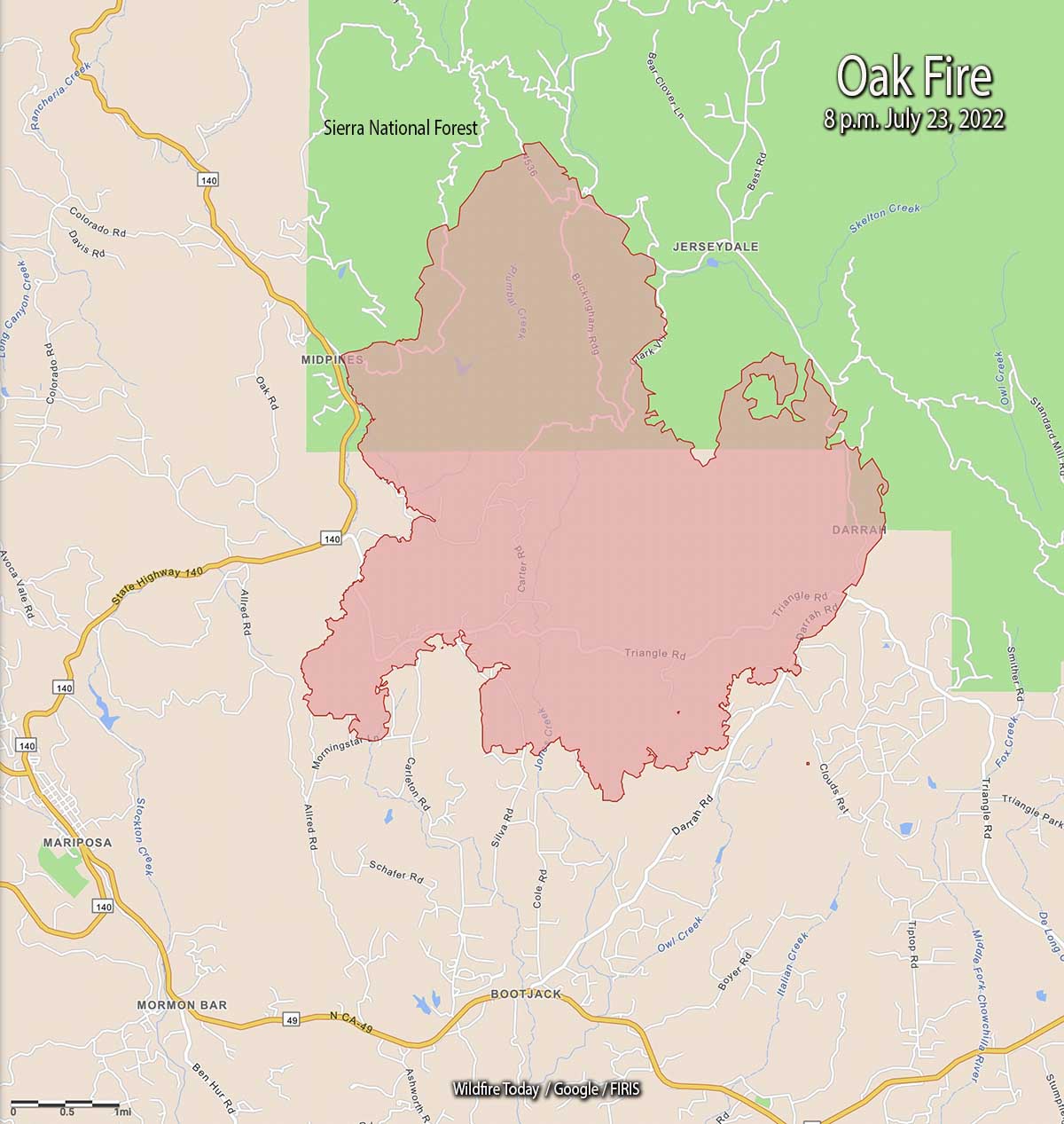
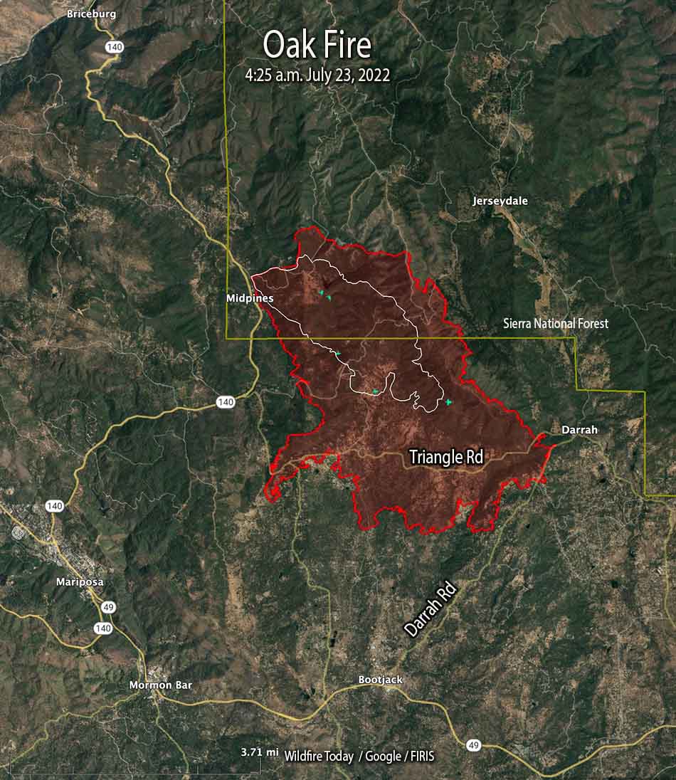
Oak Fire map. The red line was the perimeter at 10:46 p.m. PDT July 23, 2022. The white line was the perimeter at 4 a.m. July 23.
The Oak Fire two miles northeast of Mariposa, California was active on all sides Saturday and into the night. Most of the overnight movement was on the east side which saw the largest growth, spreading for one to two miles east and northeast, crossing Jerseydale road and surrounding a fire station on the road. It moved into the footprint of the Ferguson Fire which burned more than 96,000 acres four years ago.
When the fire was mapped at 10:46 p.m. Saturday night it was spreading toward Bear Clover Lane north of Jerseydale. It was six miles from Yosemite National Park, with the burn scar from the Ferguson Fire in between.
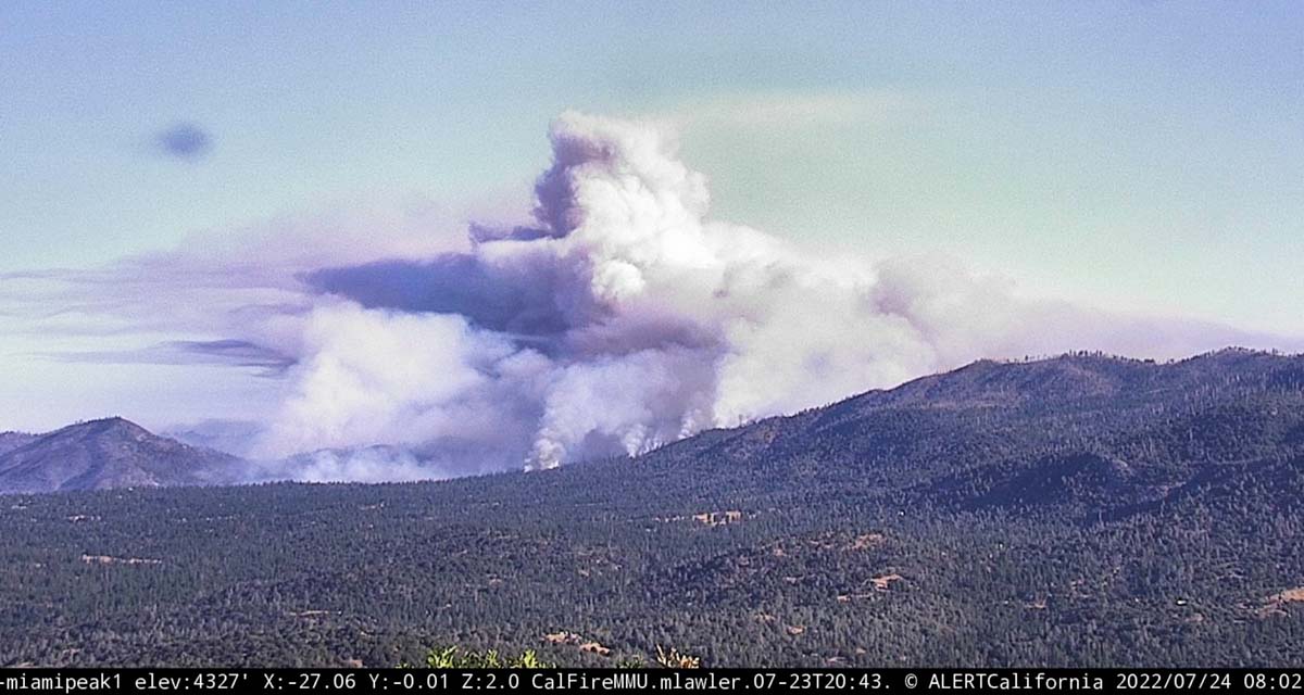
As you can see in the photo below, at 8 a.m. Sunday it was already creating a large plume of smoke.
Oak Fire, as seen from Miami Peak, looking northwest at 802 a.m. July 24, 2022.
CAL FIRE reported Sunday morning at 7 a.m. it had burned 14,281 acres since it started Friday afternoon. The number of structures destroyed remained at 10.
Oak Fire vicinity map. The red line was the perimeter at 10:46 p.m. PDT July 23, 2022. The white line was the perimeter at 4 a.m. July 23.
On the south, it crossed Triangle Road then reached and crossed in some places Darrah Road.
“The fire is moving quickly. This fire was throwing embers out in front of itself for up to 2 miles yesterday,” Daniel Patterson, a spokesman for the Sierra National Forest said Saturday. “These are exceptional fire conditions.”
Oak Fire 3-D map, east side, 10:46 p.m. PDT July 23, 2022.
As of the Saturday night mapping flight the west side has remained east of Highway 140 in the Midpines area.
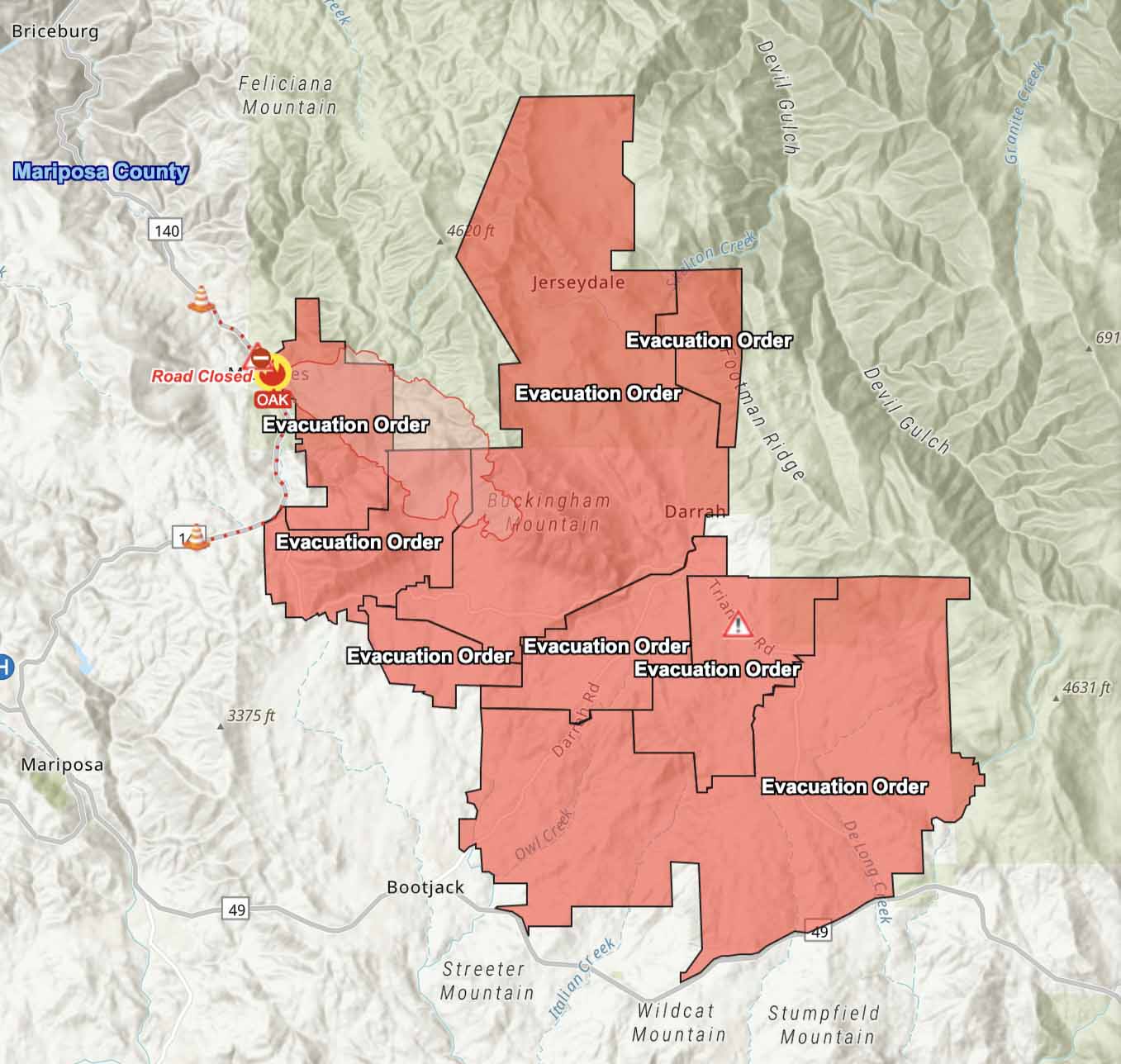
Evacuations are in effect. Mariposa County maintains a map online showing the affected areas.
Resources assigned include 17 helicopters, 225 fire engines, 58 dozers, 23 water tenders, and 51 hand crews for a total of 2,093 personnel.
Oak Fire, at dawn, July 24, 2022. Courtney Aviation.
The Oak Fire has spread to the east quite significantly, crossing Jerseydale Road about two miles south of Jerseydale in the vicinity of Wild Dove Lane.
To see all articles on Wildfire Today about the Oak Fire, including the most recent, click HERE.
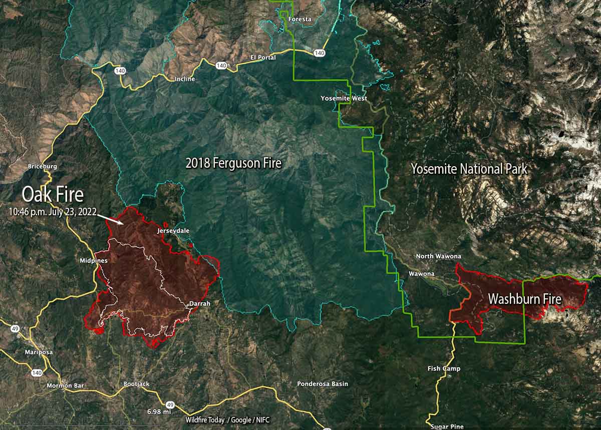
That puts it less than a mile west of the footprint of the very large Ferguson Fire which burned more than 96,000 acres in 2018. It was caused by a hot catalytic converter on a vehicle that parked in dry grass July 13, 2018 along Highway 140 near the Savage Trading Post.
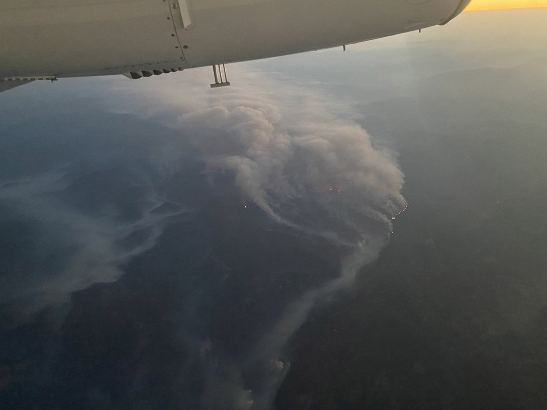
The Oak Fire is exhibiting extreme fire behavior, igniting spot fires far ahead of the main fire.
CAL FIRE announced that at 6:45 p.m. it had burned 11,900 acres.
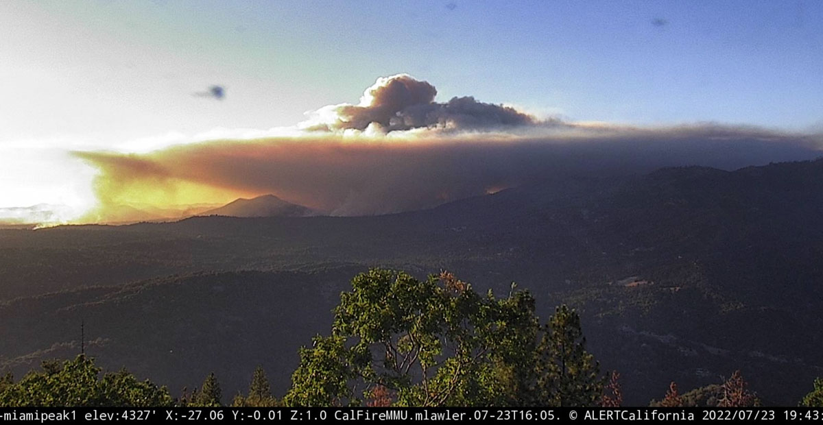
Oak Fire, as seen from Miami Peak, looking northwest at 7:43 p.m. July 23, 2022.
Updated 5:00 p.m. PDT july 23, 2022
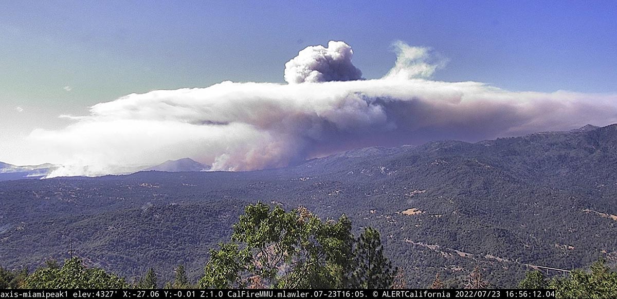
Oak Fire, looking northwest from Miami Peak at 4:57 p.m. July 23, 2022.
At approximately 4:20 p.m. Air Attack reported that the latest mapping of the Oak Fire showed had grown to 11,500 acres.
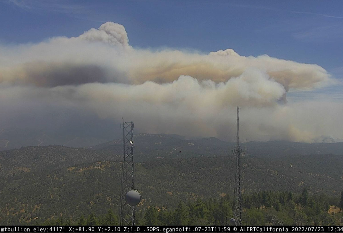
Updated 12:58 p.m. PDT July 23, 2022
Oak Fire, looking east from Mt. Bullion, 12:34 p.m. July 23, 2022. AlertWildfire.
At 11:15 a.m. Saturday the Oak Fire was mapped by Air Attack at 9,100 acres.
CAL FIRE confirms 10 structures have been destroyed. That number will likely increase.
Updated at 8:35 a.m. PDT July 23, 2022
Oak Fire map, the red line was the perimeter at 4:25 a.m. July 23, 2022. The white line was the perimeter at 5:09 p.m. July 22.
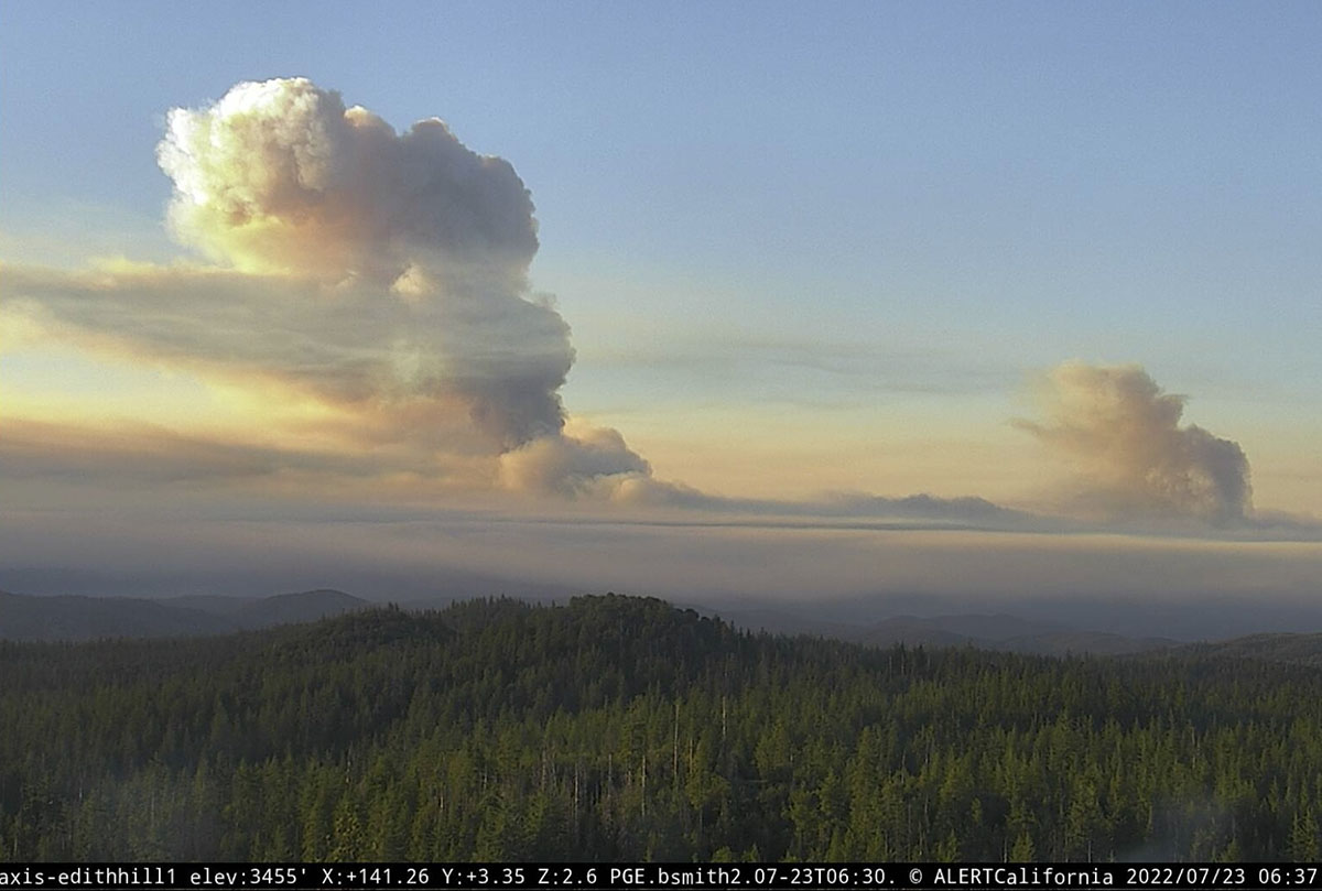
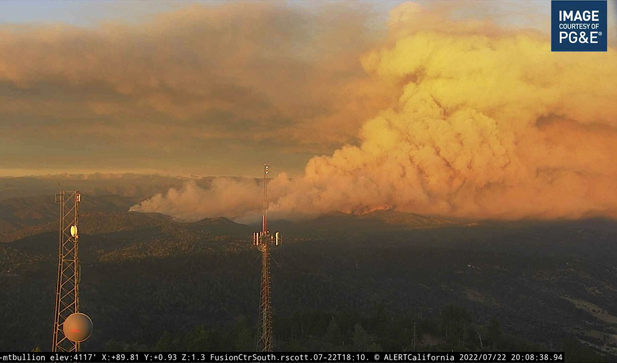
The Oak Fire at Midpines, California was active throughout much of Friday night, growing by about 2,200 acres between 10 p.m. and 4:25 a.m. Saturday when it was mapped by FIRIS at 6,555 acres. Half an hour after sunrise it was putting up two smoke columns that were quite some distance apart, with one of them creating enough energy to be capped by a pyrocumulus cloud.
Two smoke columns on the Oak Fire are seen soon after dawn, looking southeast from Edith Hill at 6:37 a.m. July 23, 2022.
Just to be clear — wildfires normally lay down at night, providing an opportunity for firefighters to move in closer and put in direct fireline. It is not common for a fire to be burning so actively soon after dawn that it is creating multiple smoke columns, especially a pyrocumulus column.
The Mariposa County Sheriff has ordered evacuations as far south as Highway 49 and east to Jerseydale. Their map is available online. As we wrote earlier, this is a dangerous fire.
The Oak Fire is spreading rapidly. When it was mapped at 4:25 a.m. Saturday it had spread south across Triangle Road and reached Darrah Road. At that time it was about a half mile west of the community of Darrah. Firefighters were planning a burning operation between Triangle Road and Darrah Road west of the town.
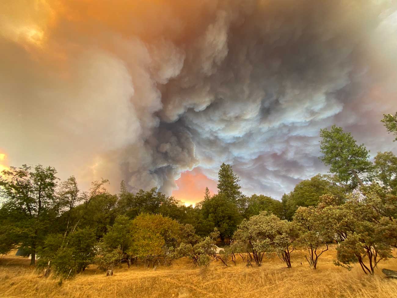
Oak Fire, Lush Meadows subdivision, Friday afternoon July 22, 2022. Credit: Chad Anderson.
Weather
The spot weather forecast for the area predicts hot and dry conditions to persist into next week. Winds will be generally light, except becoming gusty in the afternoons. On Saturday, mostly sunny skies, 90 to 94 degrees, 9 to 13 percent relative humidity, and 6 to 12 mph ridgetop winds from the south to southwest gusting to 20 mph in the afternoon. Saturday night will see poor humidity recovery, 26 to 31 percent, with very light winds. For Sunday, 10 to 14 percent RH with afternoon ridgetop winds out of the west at 4 to 8 mph.
10:36 p.m. PDT July 22, 2022
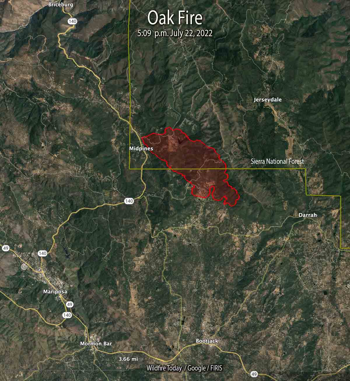
Oak Fire map at 5:09 p.m. July 22, 2022. The fire is growing rapidly and has doubled in size since this data was collected.
The Oak Fire that started Friday afternoon in Central California has been growing rapidly in Mariposa County. The County Sheriff has ordered evacuations for several areas east and southeast of Midpines. At 10 p.m. Friday it was about 4 miles northeast of Mariposa.
Evacuation Map, Oak Fire, posted by the Mariposa County Sheriff at 10:21 PDT July 22, 2022. This is a dynamic situation and the evacuation status and map may only be current only for a short while.
This is a dangerous fire. Residents should not hesitate to evacuate if there is any doubt about their safety.
At 5:09 p.m. it was mapped at 1,745 acres; at about 10 p.m. CAL FIRE reported it had grown to 4,350 acres.
Oak Fire, looking east at 8:08 p.m. July 22, 2022.
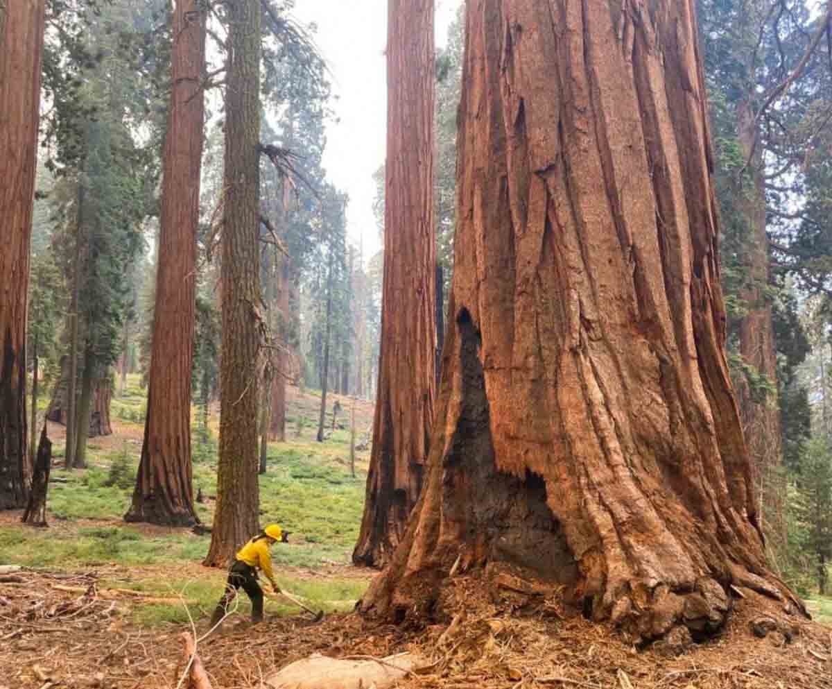
A firefighter in Yosemite National Park scrapes material away from a giant sequoia during the Washburn Fire in July 2022. NPS photo by Garrett Dickman.
Kyle Dickman has written a must-read article for Outside magazine about how the largest trees on Earth which can live for more than 3,000 years, are being increasingly affected in recent years by fire. It was published this week at the magazine and covers how management of the giant sequoias in Yosemite National Park and other areas in the Sierras has affected the vulnerability of the huge mature specimens in the groves.
The article frequently mentions Mr. Dickman’s brother, Garrett, who is the Forest Ecologist at Yosemite and has been heavily involved in managing and attempting to save the giant sequoias. The piece is extremely well written. You can read the entire article at Outside.
Below are a few excerpts:
“What nature’s doing isn’t natural,” [said Joe Suarez, the Arrowhead Hotshots superintendent]
Garrett [Dickman] and Christy Brigham, the director of science at Sequoia and Kings Canyon National Park, are standing in front of an outhouse that firefighters saved from the Castle Fire, sitting in the patchy shade of a 2,000-year-old dead tree that they did not. Firefighters protect life and property before all else—even holes to shit in, so long as they have walls around them. Listening to the two compare notes on their jobs makes clear that the fate of giant sequoias is almost entirely in the hands of a few middle managers, working at a few select parks, who navigate arcane environmental laws and a financing system cobbled together with public grants. If sequoia death is a product of American gridlock, sequoia survival will happen because of the tenacity of a few individuals.
The current drought is more intense than any experienced in California in 1,200 years.
“These next couple of years could be bad in ways we haven’t experienced yet,” Garrett says. The Park Service knows what’s coming. After 60 years trying to walk backward by managing their lands to be what conservationist Starker Leopold, who devised the agency’s guiding philosophy from the late 1960s until 2021, called “vignettes of primitive America,” the Park Service has changed course to officially recognize that park managers must intervene in ways considered antithetical to their mission two years earlier. The new policy asks the public to open its mind to everything from mechanical thinning to very limited logging. “We saw how it goes when you don’t do anything,” Christy says. “It goes terribly. It goes thousands of 2,000 year old trees burned up in an instant.”
“We don’t get to have nice things anymore,” Garrett says.”
“The Clean Water Act. The National Environmental Policy Act. The National Historic Preservation Act. The Threatened and Endangered Species Act. Fantastic laws all of them,” Christy says. “But they were built at a time when the main threat was people doing bad things—logging, mining. Now the main threat is inaction. Bureaucracy is slow. Wildfire is fast. And bureaucracy needs to get a hell of a lot faster if we want to persist and not lose everything we’ve got left.”