
The four people on board walked away
Continue readingFirefighters staging in Sacramento to assist with wildfires in Canada

On Friday U.S. Forest Service firefighters from several National Forests in California assembled at the Sacramento McClellan Airport as they were mobilized to assist with wildfires in Western Canada.
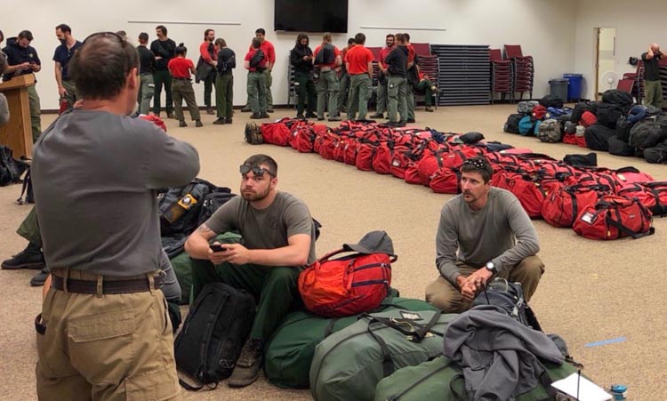
There is a report that two 20-person crews from South Africa are also en route.
Air tankers working the Chuckegg Creek Fire in Alberta
 Air tankers on the Chuckegg Creek Fire. Alberta Fire photo.
The large aircraft on the left is the Electra L-188. It has four turbine engines, can cruise at 592 km/hr (368 mph), and can carry 11,365 liters (3,000 gallons) of fire retardant.
To the right of the Electra are four of the Air Tractor 802F amphibious aircraft. They can work as land-based or skimmer air tankers. They have a cruising speed of 260 km/hr (161 mph) and can carry up to 2,430 liters (644 gallons).
The Chuckegg Creek Fire in northern Alberta has burned 276,000 hectares (682,000 acres).
U.S. crews en route to assist with wildfires in Canada
 Firefighters, heavy equipment, and aircraft continue to work on the McMillan Complex in Alberta which is approximately 22km northeast of the junction of Highway 88 and Highway 754. The complex is comprised of 4 wildfires that are a combined 215,065 hectares (531,439 acres) in size. Alberta Fire photo.
At least five hotshot crews from Oregon and Montana will be leaving Wednesday to assist with the wildfires in Alberta.
Kathy Bushnell of the Helena-Lewis and Clark National Forest said Montana hotshot crews from the Helena, Lolo, Bitterroot and Flathead national forests will travel north with the Rogue River Hotshots from Oregon.
Deb Schweizer of the USFS office in Boise told Wildfire Today that an additional 15 personnel are being mobilized for a variety of overhead positions.
Thanks and a tip of the hat go out to Tom. Typos or errors, report them HERE.
Canadian wildfire smoke decreasing in United States

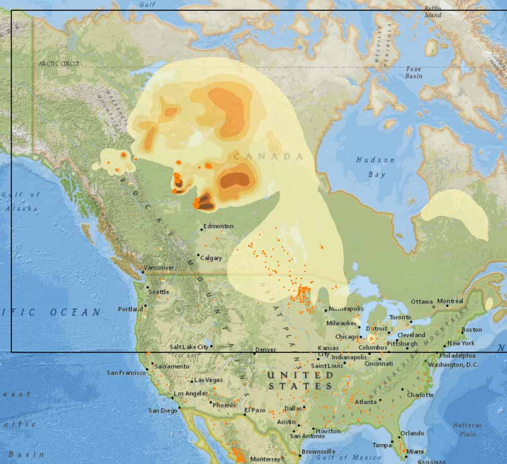
Smoke from wildfires in Alberta is still detectable across most of the Eastern United States today, but the Canadian government’s smoke forecast expects a significant decrease throughout the lower 48 states on Monday.
Cooler weather along with a slight chance of showers off and on in Alberta over the last several days has slowed the progress of the wildfires, including the 230,000-hectare (568,000-acre) Chuckegg Creek Fire at the town of High Level. Those conditions are expected to continue during this week, so it appears that U.S. residents will get a respite from polluted air that at times has been very unpleasant in the Northwest, especially along the Canadian border in Montana and Idaho.
The map above represents conditions today, Sunday June 2. The map below is the Canadian government’s forecast for smoke tomorrow, June 3. The Canadian system does not predict smoke conditions in the south half of the U.S. (outside of the box with the black lines).
Chuckegg Creek Fire in Alberta grows to over half a million acres
Will it become a million-acre “gigafire”?
Continue readingSatellite photo showing the three major fires active in Northern Alberta
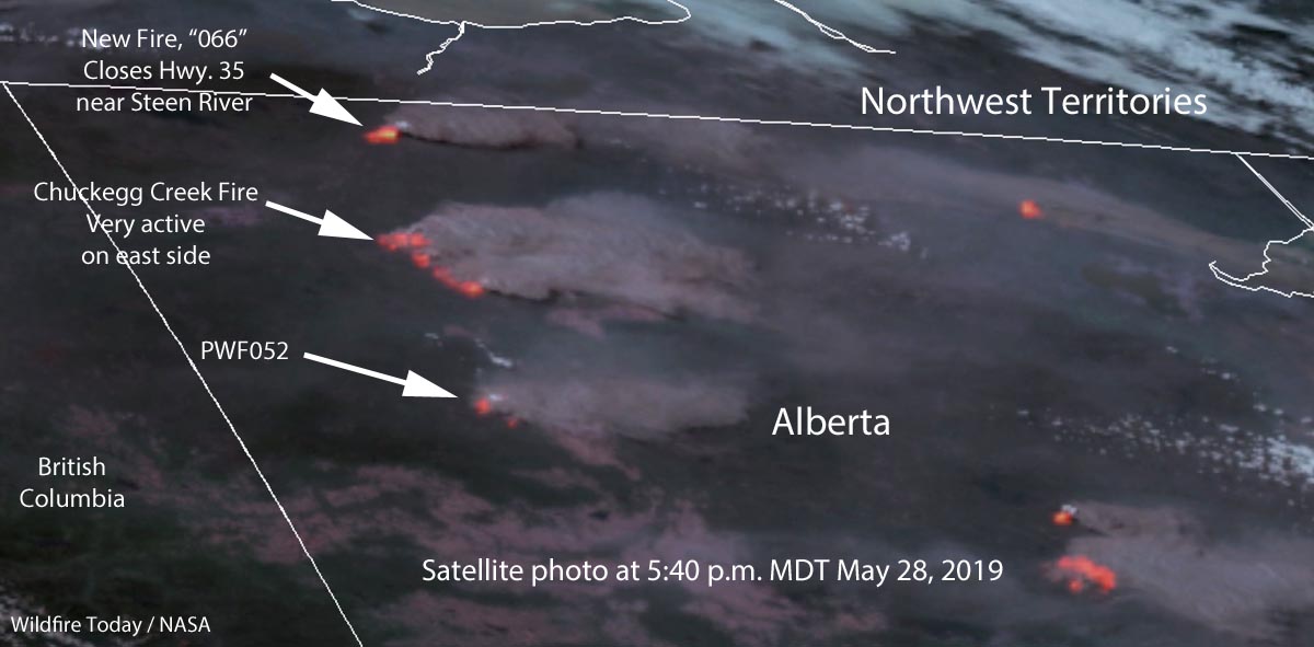
This satellite photo taken at 5:40 p.m. MDT April 28 shows the locations of three major wildfires in Northern Alberta. The imagery was enhanced to enhanced to show the heat generated by the active fires.
As predicted, the wind on Tuesday was out of the west which made the east sides of the fire more active than they had been in recent days. As you can see in the photo large amounts of smoke are flowing off to the east. Click here to see an analysis and map of wildfire smoke in North America today.
The northern-most fire identified on the map is a relatively new blaze, known as “066”. Alberta Wildfire said Tuesday afternoon, “[The fire] is approximately 6 km west of Highway 35 near Steen River. Highway 35 North of High Level is closed due to smoke – monitor Alberta511 for updated highway conditions.”
Update: Highway 35 CLOSED approximately 7 km north of Steen River, north of High level due to wildfire. Southbound traffic will be held in Enterprise – North West Territories and Northbound traffic will be held in High Level. (3:49pm) #ABRoads https://t.co/fPMAgLqR2A
— 511 Alberta (@511Alberta) May 28, 2019
The air quality in the town of High Level, Alberta has reached dangerous levels.
I have never seen levels like this for PM2.5. High Level AB is in serious trouble. pic.twitter.com/Vn2TUAlH3M
— Dr. Michael D Mehta (@MichaelMehta) May 28, 2019
A better look at the pyrocumulus over the Chuckegg Creek Fire in Alberta
Compare two satellite images
Continue readingFirefighters continue to defend High Level, Alberta
The Chuckegg Creek Fire has burned more than a quarter-million acres
Continue readingFirefighters working to protect town of High Level
The Chuckegg Creek Fire in Northern Alberta has burned more than 241,000 acres (97,600 hectares)
Continue reading