500 firefighters from U.S. and South Africa mobilized to Canada

Following up on our story from May 23 when Canada requested 200 firefighters from the United States, the order was filled today when the National Interagency Fire Center (NIFC) mobilized 10 hand crews to assist with the Fort McMurray fire in Canada. Five of the crews flew on a Canadian aircraft out of NIFC in Boise, Idaho, at 9:15 a.m. and another five departed from Missoula, Montana. The crews are comprised of Bureau of Land Management, U.S. Forest Service and U.S. Fish and Wildlife Service wildland firefighters.

In addition, 300 firefighters from South Africa will also assist the Canadians.

South African firefighters Canada
The largest ever deployment of firefighters from South Africa, from Working on Fire, were mobilized to Canada.

“We have a bilateral firefighting assistance agreement with the Canadian Interagency Forest Fire Centre, which works well when either country is in need of wildland fire suppression resources. Canada has assisted the U.S. many times in the past, so as soon as Canada requested assistance, we quickly accommodated their request,” says Dan Buckley, NIFC’s National Multi-Agency Coordinating Group Chair.

On May 10, the U.S. mobilized two heavy air tankers and a lead plane to assist with wildfires in Canada. The tankers, based out of Bemidji, Minnesota, flew retardant to wildfires in the Ontario province for one day. In the last 5 years, the U.S. has supported Canada twice. In 2015, NIFC mobilized 200 firefighters and one heavy air tanker and in 2010, 30 smokejumpers and one Type 2 Initial attack crew were sent to Quebec.

Conversely, Canada has provided support for wildfires in the U.S. For each of the last five years, the Canadian Interagency Forest Fire Centre (CIFFC) mobilized fire managers, large air tankers, smokejumpers and wildland fire crews.

Firefighters to Canada 1

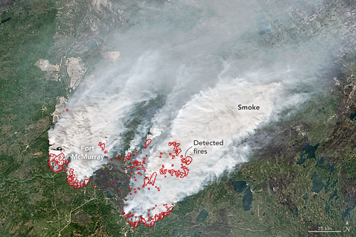
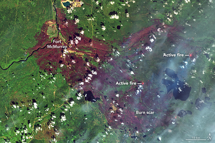
Fort McMurray Fire as seen from space

Fort McMurray fire
Fort McMurray fire, May 12, 2016. NASA.

NASA provided these images of the wildfire at Fort McMurray (Horse River Fire) in Alberta as seen from the Landsat 8 satellite. The one above was acquired on May 12, a day when there was little activity on the fire. In contrast to that, check out the image below taken on May 16 when conditions were very different.

Our most recent comprehensive article about the Fort McMurray Fire is HERE.

Fort McMurray fire, May 16
Fort McMurray fire, May 16, 2016. NASA.

Fort McMurray Fire spreads into Saskatchewan

(UPDATED at 10:40 a.m. MDT, May 19, 2016)

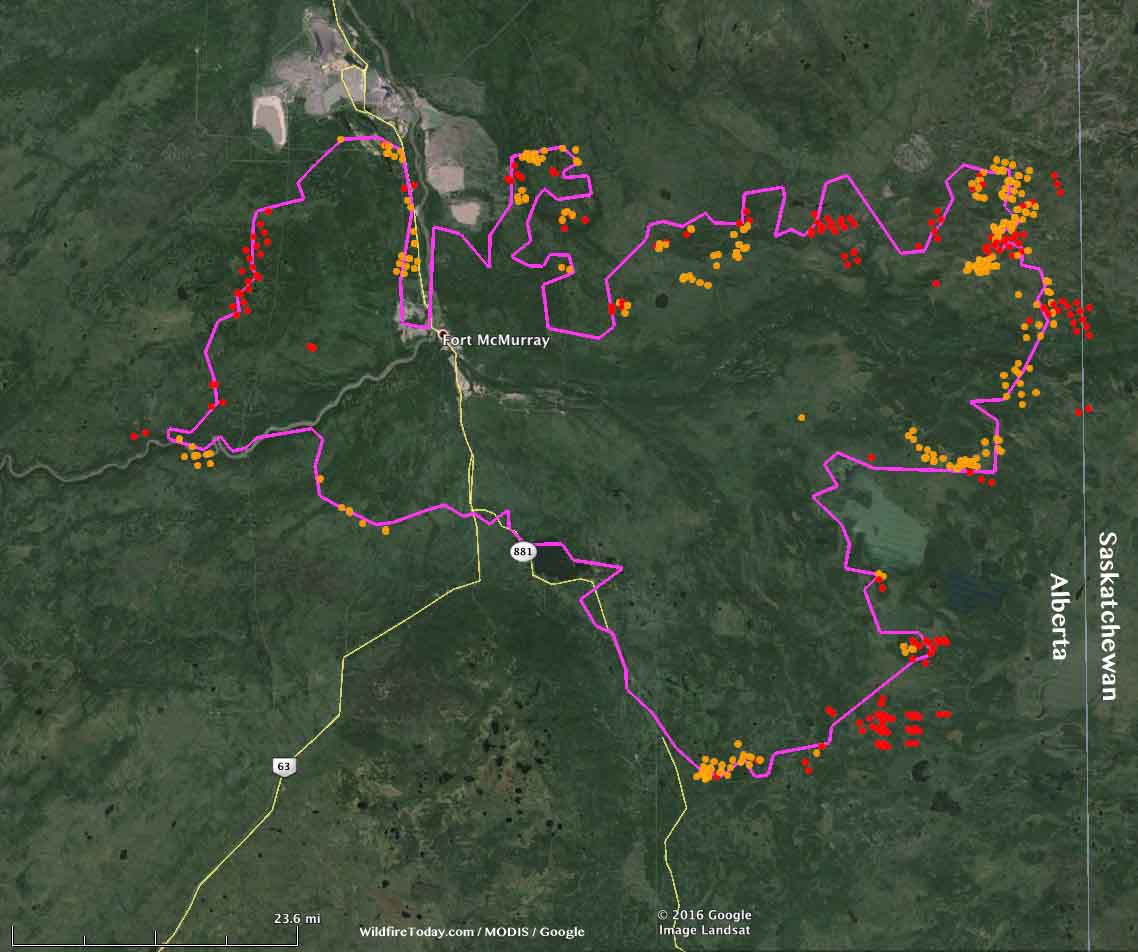
Fort McMurray Fire wildfire map
Map of the Fort McMurray Fire (Horse River Fire). The purple line was the approximate perimeter the morning of May 18, 2016. The dots represent heat detected by a satellite within the last 24 hours, with red being the most recent, as late as 10:25 p.m. MDT May 18, 2016. Click on the map to see a larger version.

The Fort McMurray Fire (Horse River Fire) was not as active Wednesday as it has been in the preceding three days, but it did move east several kilometers and crossed the boundary from Alberta into Saskatchewan.

The weather forecast through Sunday calls for more moderate conditions and a good chance of rain on Thursday, Saturday, and Sunday. Next week should be clear and warmer.

****

(UPDATE at 8:50 a.m. MDT, May 18, 2016)

Above: Video of the Fort McMurray Fire approaching the Noralta Camp, shot by CEO Ft. Mckay Enterprises.

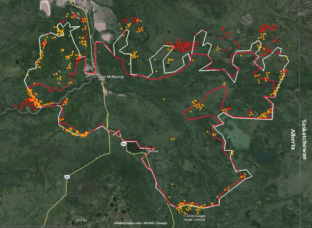
The Fort McMurray Fire (Horse River Fire) has enlarged its footprint over the last two days to 422,898 hectares (1,045,022 acres, 1,632 square miles). On May 16 it was mapped at 284,000 hectares (702,000 acres, 1,097 square miles). The east side of the fire is approximately 3 miles (5 kilometers) from the Saskatchewan border.

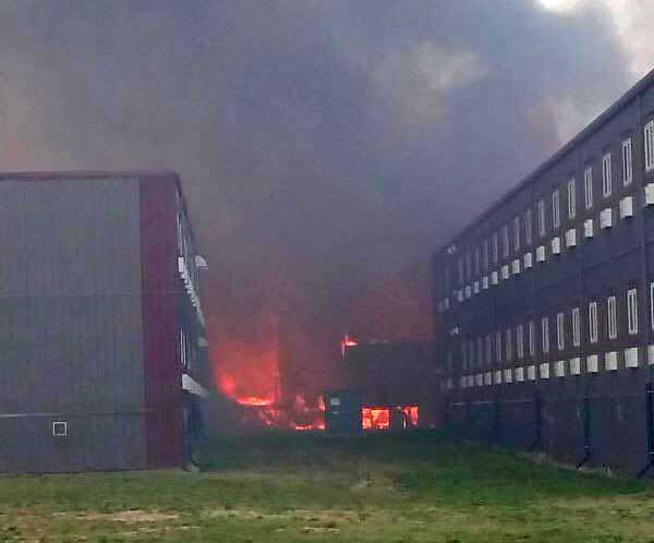
On Tuesday the fire reached the Black Sands Camp and burned the Executive Lodge with its 665 units in spite of the building’s sprinkler system. It next spread to the Noralta Camp that houses 3,000 people, but at the last report firefighters held the fire at bay with no damage to the structures.

Black Sands Camp wildfire
Black Sands Camp just north of Fort McMurray, Alberta. Via Karen Lavallee
Fort McMurray Fire map
Map of the Fort McMurray Fire (Horse River Fire). The red line was the approximate perimeter the morning of May 16, 2016. The white line was from May 17. The dots represent heat detected by a satellite within the last 24 hours, with red being the most recent, as late as 3.32 a.m. MDT May 18, 2016. Click on the map to see a larger version.

Two houses recently exploded in Fort McMurray, damaging ten other nearby homes. The causes are unknown.

The warm, dry weather that has contributed to this growth will continue today with a high temperature at Fort McMurray of 75 °F, a relative humidity of 28 percent, west winds at 8 to 12 mph, and partly cloudy skies. That will change on Thursday when it should be 20 °F cooler with an RH above 60 percent, and a 50 percent chance of rain.

Continue reading

Smoke mixes with clouds in Alberta

smoke - clouds Alberta
Photo: NOAA/NASA

The photo shows smoke from the huge fire at Fort McMurray, Alberta mixing with clouds. The image was acquired Monday May 9 by the Suomi National Polar-orbiting Partnership satellite and NASA’s Aqua satellite.

To see the most current smoke reports on Wildfire Today, visit the articles tagged “smoke” at https://wildfiretoday.com/tag/smoke/

NIFC mobilizes air tankers to assist Canada

A BAe-146 air tanker dropping on a recent wildfire in Canada.
A BAe-146 air tanker dropping on the Kenora #18 Fire in Canada. Photo by Chris Sherwin.

This article was first published on Fire Aviation.

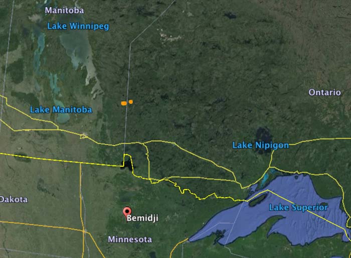
The National Interagency Fire Center has mobilized two BAe-146 air tankers and one King Air lead plane to assist the Canadian provinces of Ontario and Manitoba. Tankers 10 and 41 will be working out of the air tanker base at Bemidji, Minnesota 86 miles south of the US/Canadian border.

The aircraft were ordered primarily for the Kenora #18 Fire that straddles the border between Manitoba and Ontario (the brown dots in the map below). But they could be used for fires in either province.

According to the U.S. National Interagency Fire Center, Canada has not requested U.S. assistance specifically for wildfires in Alberta. The aid, they said, was requested through a bilateral firefighting assistance agreement with the Canadian Interagency Fire Center (CIFC). At this time, Canada has not requested additional resources or assistance from the U.S., though NIFC and the CIFC are frequently communicating.

Map Ontario Manitoba US

Pressure for a “CNN deployment” to Alberta

I have seen chatter in recent days, here and elsewhere, very critical of both the United States for not sending firefighters to help out with the large wildfire in Alberta, and of Canada for not asking for help. Alberta Wildfire Management has said they have enough firefighting resources and don’t need international assistance. We checked with Jennifer Jones, a spokesperson for the U.S. Forest Service at the National Interagency Fire Center, and she confirmed that the United States government has not been asked by Canada for any resources.

It is unfortunate that this natural disaster has turned into a political football in some circles. Generally wildland firefighters are isolated from politics, other than depending on politicians for funding and occasionally succumbing to pressure to put air tankers in the sky even though they know that in certain conditions they will be completely ineffective. Firefighters call the retardant delivered to a fire under those conditions “CNN drops” — made for television — simply to appease the public and reduce the pressure felt by politicians. Thankfully CNN drops are rare.

But this pressure to send United States firefighters or hardware to Alberta falls into that same category. It would be a CNN deployment. Photos would be taken of firefighters boarding planes headed north, and then lining up at an Incident Command Post in Alberta. 

The fire management personnel in Canada say they’ve got this. The United States, Russia, Mexico, Australia, Taiwan, Israel and the Palestinian Authority all offered help, according to John Babcock, a Global Affairs Canada spokesperson, but it is not needed.

Canada and the U.S. have often helped each other out, lending ground personnel and aircraft back and forth to assist during unusually busy wildfire seasons. There is no hesitancy to do this. People criticizing politicians and fire management personnel about a perceived lack of sharing need to calm down. Let the professionals decide what they need and don’t need. To a firefighter, a fire is not an emergency. It’s what they do.

If Alberta needs help, they’ll ask for it. If they ask, the U.S. will send resources north.

Alberta to use drones to help find origin of fire at Fort McMurray

Reuters is reporting that the Alberta Government will use drones to help narrow down the point of origin of the huge wildfire that has burned 157,000 hectares (387,000 acres) at Fort McMurray and forced the evacuation of the entire city of more than 80,000 residents.

Below is an excerpt from the article:

…Elevated Robotic Services, which has also deployed drones for mining and construction companies, has contracts with the Alberta government and insurance broker Hub International Ltd [HBINT.UL], said Mat Matthews, the Edmonton company’s operations and safety manager.

The drones use cameras outfitted with infrared, ultraviolet and traditional optical cameras to pinpoint the hottest part of the fire and trace it to its source based on time, wind and other factors. The cameras will shoot about 800 images, which are then stitched together in a process called fire-mapping.

The work begins on Tuesday, coordinated with the other air traffic, including air tankers and helicopters.

The images, if successful, will zero down to a spot on the ground with about a 30-foot (9-meter) radius where the fire is believed to have started. From there, investigators will search on foot for the cause, such as a lightning strike or campfire.

Using the more traditional method of gathering images from helicopters, the fire’s cause could be narrowed only to half an acre, a much larger area to search on the ground, said Ron Windmueller, owner of Droneology, which supplies equipment and other services to Elevated.

Downward wind from helicopter blades can disturb the scene, forcing the pilot to stay about 1,000 feet in the air. A drone can capture images from 100 feet.

Wildfire smoke from Canada affects much of the United States, May 8, 2016

(UPDATED at 4:30 p.m. MDT, May 8, 2016)

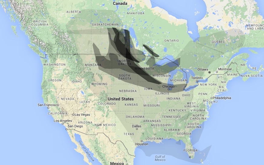
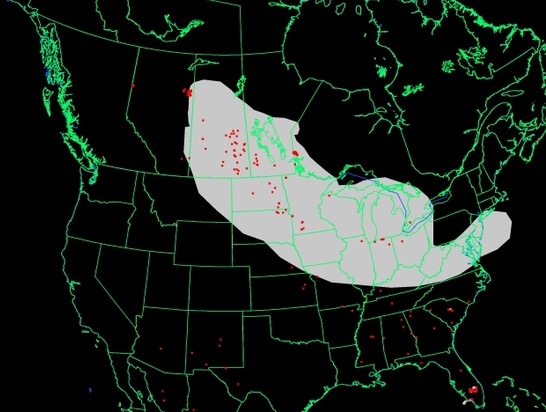
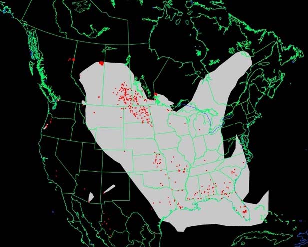
These first two maps are updated versions of the wildfire smoke maps down below. The smoke has gotten a little closer to the northeast United States.

Wildfire Smoke map
Wildfire Smoke map, Weatherunderground, 4:30 p.m. May 8, 2016
Wildfire Smoke map
Wildfire Smoke map, NOAA 3:17 p.m. May 8, 2016

****

(Originally published at 12:31 a.m. MDT, May 8, 2016)

Wildfire smoke
Wildfire smoke, at 12:05 a.m. May 8, 2016. WeatherUnderground

The fires in Alberta, Canada continue to create smoke that drifts into into Saskatchewan, Manitoba, the central United States, and many areas in the eastern U.S.

Wildfire smoke
Wildfire smoke map generated at 10:24 p.m. May 7, 2016. NOAA.

To see the most current smoke reports on Wildfire Today, visit the articles tagged “smoke” at https://wildfiretoday.com/tag/smoke/