NPS releases information about the Chimney Tops 2 Fire

The fire burned from Great Smoky Mountains National Park into Gatlinburg, Tennessee November 28.

Above: Chimney Tops 2 Fire November 27, 2016. Photo by Brett Bevill.

On December 13 the National Park Service delivered a verbal statement and released two documents about the Chimney Tops 2 Fire.

The fire killed 14 people and destroyed 2,013 homes and 53 commercial structures. An additional 244 homes were damaged.

At a news conference on Tuesday Great Smoky Mountains National Park (GRSM) Deputy Superintendent Clay Jordan read a 13 minute statement covering the day by day events from the time the fire was ignited by teenaged arsonists on November 23 to when it burned into Gatlinburg on November 28.

Mr. Jordan said, “On Saturday [November 27 two days before the fire burned into Gatlinburg] we requested a four-day near-term analysis from the U.S. Forest Service at the Rocky Mountain Research Station.” He went on to say, “Their analysis modeled low fire growth downhill over the next couple of days as the fire approached the containment boundary. This analysis did not forecast the behavior the fire generated on Monday.”

Mr. Jordan said Monday morning, November 29, spot fires created by lofted burning embers had occurred “as far as one-half to a mile from the main fire burning on Chimney Top.”

He concluded his presentation by saying:

We believe there is no way we could have controlled this fire prior to the wind event. The reality is we believe there is no number of firefighters or fire engines that could have stopped the spread of this fire in such extreme wind conditions.

We will continue to explore lessons learned from this incident and we appreciate the outpouring of support and resources that we have received from across the nation to help us fight this fire.

Below is a video recording of Mr. Jordan’s statement.

The documents released included a chronology and a .pdf of a presentation featuring maps. The presentation, a very large document, can be downloaded from Google Drive.

The chronology does not contain much more information than the analysis we published on December 5, 2016.

The presentation has a map showing the location of 911 calls, which is interesting.

911 calls gatlinburg fire
911 calls up to 10 a.m. November 29, 2016. From the NPS presentation.

From our interviews with people associated with the fire and the information released yesterday, it is clear that no action was taken by ground-based firefighters to actively suppress or stop the spread of the fire until Sunday, November 27, four days after the fire started. The activity that day involved constructing fire line and improving the natural boundaries of containment lines about half a mile away from the fire.

The chronology document released on December 13 implied that three large Type 1 helicopters dropped water on the fire “throughout the day” on Sunday November 27. But the information we obtained, which was confirmed by Mr. Jordan’s presentation yesterday, showed that the drops only occurred in the afternoon. This was the first time any direct suppression occurred on the fire up to that point.

That afternoon a Chinook Type 1 helicopter began dropping water on the fire, refilling at Fontana Lake 13 miles to the southwest, according to a source we talked to who didn’t want their name disclosed because they were not authorized to speak on the subject. The helicopter worked until it had to refuel and then two other Type 1 helicopters took its place until dark. Sunset that day was at 5:21 p.m. which would have allowed them to drop on the fire until 5:51 p.m., 30 minutes after sunset. This 26-mile round trip to refill with water greatly reduced the amount of water delivered to the fire, compared to how much could have been dropped if a closer water source had been used.

During the previous four days no nearby helicopter water sources were identified or created. Often on structure and wildland fires portable, collapsable water tanks are quickly set up for engines or helicopters to draft from or dip into with their buckets. Some of the larger tanks, such as the Heliwell, can hold almost 15,000 gallons. These tanks can be kept full if connected to a fire hydrant or filled with a water tender shuttle.

heliwell helicopter
A Heliwell tank used to refill the helicopter bucket on the Red Canyon Fire July 9, 2016 in the Black Hills. Photo by Bill Gabbert.

If a good water source had been created or identified on day two of the fire and helicopters had been ordered then instead of day five, hundreds of thousands of gallons of water could have been dropped on the fire in the four days before the wind increased on Monday, November 28.

Aircraft dropping water or fire retardant on a fire cannot put it out. However, if huge amounts of water are applied to a relatively small fire in a “wash the fire off the hill” approach, it can have a very positive effect.

Under normal circumstances limited amounts of liquids dropped from the air can be most effective if firefighters on the ground can move in quickly to take advantage of the short term change in fire behavior by constructing firelines, stopping the spread at that location. In this case, there were no firefighters in a position to take direct action.

For two weeks in numerous documents and presentations the NPS has been saying that wind gusts up to 87 mph were recorded at the Cove Mountain weather station 8 miles northwest of the fire’s origin and 4.5 miles west of downtown Gatlinburg. We have been attempting to obtain a copy of the data recorded by that station before it shut down at about 9 p.m. on November 28 when it lost electrical power. On December 15 we were told by GRSM spokesperson Dana Soehn that the data will not be released for at least two to three months because it has to go through a quality control process by multiple agencies. So in other words, they are not sure the data is accurate, but are very comfortable cherry picking one number and repeating it over and over.

However, weather data from numerous other stations is readily available.

At 2 a.m. Monday November 28, the day the fire burned into Gatlinburg, the wind speeds recorded at the Indian Grave weather station 18 miles west of the fire began increasing and the direction became more consistently out of the south and southwest. Until 1 p.m. sustained speeds were 4 to 6 mph with gusts at 12 to 19 mph. Between 2 p.m. and 6 p.m. they increased to 7 to 15 mph with gusts of 22 to 32 mph — all generally out of the south, blowing toward Gatlinburg. From 7 p.m. until midnight sustained winds were at 13 to 17 mph with gusts from 34 to 49.

This data from Indian Grave was not very different from the forecast issued the day before, Sunday November 27 at 7:29 a.m. That Spot Forecast, specifically for the fire area, predicted strong winds all day on Monday — at 7 a.m. 12 mph gusting to 25 and increasing throughout the day to 20 mph gusting to 40 by 6 p.m.

We were not able to find a Spot Forecast for the fire that was requested or issued on Monday, November 28.

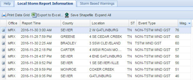
The highest wind speeds reported by the National Weather Service’s Local Storm Report Information system in that part of Tennessee on November 28 were gusts of 56 and 60 mph in Bradley and Sevier Counties, respectively.

Below is a copy of the Spot Weather Forecast issued at 7:20 a.m. Sunday November 27, 2016, and following that, data from the Indian Grave weather station:

Continue reading “NPS releases information about the Chimney Tops 2 Fire”

Firefighters gaining control of the Chimney Tops 2 Fire at Gatlinburg, TN

Above: Structures damaged or destroyed in the Chimney Tops 2 Fire and other fires in the Gatlinburg, Tennessee area.

Fire suppression activities on the Chimney Tops 2 Fire at Gatlinburg, Tennessee are winding down as firefighters continue to increase their control of the 17,006-acre fire that burned into the nearby communities. The fire resulted in the deaths of 14 people and damaged or destroyed 2,460 structures.

The park opened several roads to the public on Friday including US 441, Newfound Gap Road from the Gatlinburg Entrance to Cherokee, NC, Little River Road, the Spur between Pigeon Forge and Gatlinburg, and the Gatlinburg Bypass.

An interactive map is available showing which structures have been destroyed and damaged.

On Saturday the Type 1 Incident Management Team was released and the South Atlantic Incident Management Team assumed command.

map firefighters
Map showing the home units of the personnel that have worked on the Chimney Tops 2 Fire in Tennessee. It only includes folks ordered through the Resource Ordering and Status System, but not local firefighters in the Gatlinburg area. The full, zoomable map can be seen here.

The number of firefighting resources has decreased and now includes 8 hand crews, 17 engines, 1 helicopter, and 1 water tender, for a total of 306 personnel.

Public meeting, uploaded by the Incident Management Team December 9, 2016.

For the most current information about the Chimney Tops 2 Fire at Gatlinburg, see our articles tagged “Chimney 2 Fire”.

Two juveniles charged with starting fire that burned into Gatlinburg

The juveniles were taken into custody Wednesday after an interagency investigation.

Above: Chimney Tops 2 Fire. Incident Management Team photo.

On Wednesday two juveniles were charged with aggravated arson for starting the Chimney Tops 2 Fire that burned into Gatlinburg, Tennessee. The fire resulted in the deaths of 14 people and damaged or destroyed 2,460 structures.

The juveniles were taken into custody after an investigation conducted by the Tennessee Bureau of Investigation, National Park Service, Bureau of Alcohol, Tobacco, Firearms and Explosives, and the Sevier County Sheriff’s Office.

Due to laws regulating the handling of juveniles, very little was disclosed about the two individuals, except that they do not live in Sevier County but are residents of the state of Tennessee.

Steve Kloster, Chief Ranger of Great Smoky Mountains National Park
Steve Kloster, Chief Ranger of Great Smoky Mountains National Park, speaks at a news conference about the Chimney Tops 2 Fire, December 7, 2016.

Steve Kloster, Chief Ranger of Great Smoky Mountains National Park, said the phone line established to gather information proved to be valuable.

The public was critical in responding to that tip line and giving the investigators something to work with. The tip line had about 40 tips within just a few minutes of going online.

The fire was reported November 23 in Great Smoky Mountains National Park. By November 27 it had grown to 35 acres while being monitored by the National Park Service. A cold front brought very strong winds into the area on November 28 which caused the fire to spread explosively north into Gatlinburg, destroying lives, homes, businesses, and eventually 17,006 acres.

Below is a video of the press conference announcing the arrest.

For the most current information about the Chimney Tops 2 Fire at Gatlinburg, see our articles tagged “Chimney 2 Fire”.

How Gatlinburg attempted to notify its residents to evacuate as the fire burned into the city

This WBIR video explains the various systems for communicating emergency messages, such as evacuations, to the public, and why they did not work very well as the Chimney Tops 2 Fire burned into Gatlinburg, Tennessee last week.

There are multiple emergency alert systems but according to WBIR the one used by the National Weather Service can only push an emergency message to cell phones for one of the following situations: tornado, flash flooding, extreme wind, hurricane, typhoon, dust storm, or tsunami. Wildfire is not on the list, which seems, especially in retrospect after Gatlinburg, to be a serious oversight.

It is a good lesson that could be learned by communities at risk from wildfire and other emergencies.

Analyzing the fire that burned into Gatlinburg

Above: The Drought Monitor issued November 29 showed “Exceptional Drought”, the highest category, for the Gatlinburg area and large sections of Tennessee, Georgia, Alabama, North Carolina, and South Carolina.

On Monday, December 5, the Incident Management Team (IMT) on the Chimney Tops 2 Fire that burned from Great Smoky Mountains National Park (GRSM) into the Gatlinburg area reported that it has caused the deaths of 14 people. Over 130 sustained injuries, and 1,684 structures have been damaged or destroyed. Approximately 14,000 residents were originally forced to evacuate.

There are three broad categories of conditions that affect the way a wildfire burns: weather, fuels (vegetation), and topography. When the Chimney Tops 2 Fire burned into Gatlinburg on November 28, 2016 and destroyed those structures it was driven primarily by weather — specifically, very strong winds.

But the condition of the fuel was also important since it happened during what the National Weather Service (NWS) calls “exceptional drought” conditions. Much of the southeastern United States had been suffering extremely dry conditions for two to three months.

One indicator of drought and its effect on how wildfires burn is the Keetch-Byram Drought Index (KBDI). (The fire was in eastern Tennessee near the North Carolina border.)

Keetch-Byram Drought Index
We have asked for a standard KBDI graph usually used by fire managers showing the 2016 KBDI, the average KBDI by date, and the maximum recorded by date. When we receive it, we will add it to the article.

On November 23 when the fire was discovered the KBDI was 599, Molly Schroer, a spokesperson for the IMT told us. For reference, 600 or above would indicate severe drought and increased wildfire occurrence. Intense, deep burning fires with significant downwind spotting should be expected. A fire burning under those conditions would likely burn more intensely, have a rate of spread faster than normal, and have more resistance to control. Many fire managers in that situation would immediately attack emerging fires very aggressively with overwhelming force, that is, many firefighters on the ground assisted by numerous aircraft dropping water or fire retardant.

Ms. Schroer said she was not aware of any actual on-the-ground fire suppression efforts, other than perhaps some work on a distant indirect fireline, until Monday November 28, after the fire had grown large and crossed US Highway 141, the main road into the park. That is when it began moving rapidly toward Gatlinburg. Firefighting aircraft were not used until helicopters dropped water on the fire Sunday afternoon, November 27 four days after it started.

Wednesday, November 23, the day the fire started

At about 5:20 p.m. the fire was discovered near the top of a steep hill called Chimney Tops not far from where another fire occurred about a week before. GRSM firefighters spotted the new fire as they returned from responding to a report of a vehicle fire.  The earlier fire on the hill was named “Chimney Tops” — hence the name “Chimney Tops 2” for the new blaze.

According to Ms. Schroer, firefighters walked up the Chimney Tops Trail to the top of the hill to size it up. But very little if any fire suppression activity occurred until Monday, November 28. The action taken by firefighters on Monday was defensive, to protect threatened structures at a nearby National Park Service picnic ground.

Investigators have determined that the fire was human-caused and are asking for information from anyone who has information about people or vehicles that were seen in the area that day. The Tip Line is 888-653-0009.

Narrowing it down to human-causes is easy for an investigator. It means they eliminated natural causes, such as lightning and volcano eruptions. The fire could have been accidental, or it may have been intentional.

investigator national park service
An investigator from the National Park Service’s Investigative Services Branch looks for evidence at Chimney Tops. NPS photo.

Continue reading “Analyzing the fire that burned into Gatlinburg”

Update on wildfire at Gatlinburg, December 2, 2016

Above: Map showing the perimeter of the Chimney Tops 2 Fire at Gatlinburg, Tennessee as of 11 p.m. ET December 1, 2016.

(UPDATED at 4:12 p.m. ET, December 2, 2016)

Today for the first time since Gatlinburg was evacuated residents will be allowed into the city to access their property. They can enter the area between 10 a.m. and 5 p.m. today through December 6th.

According to CNN the number of confirmed fatalities has increased to 13:

Of the 13 who died, 12 were killed in the fires, and one person died of a heart attack after fleeing and being exposed to smoke, [Sevier County Mayor Larry] Waters and the county’s assistant medical examiner, Dr. Vincent Tolley, said.

The estimated number of structures destroyed officially remains at 700; it is likely that will change after the surveys are complete.

The Chimney Tops 2 Fire that burned into the city on November 29 has been mapped at 17,859 acres. Firefighting resources assigned to the fire include 17 hand crews, 31 engines, 6 helicopters, and 5 dozers for a total of 458 personnel.

The National Park Service Investigative Branch Services and the Bureau of Alcohol, Tobacco, Firearms and Explosives (ATF) continue to investigate the origin of the fire — it appears to be human caused. The park is asking for assistance from the public to gather information. 

For the most current information about the Chimney Tops 2 Fire at Gatlinburg, see our articles tagged “Chimney 2 Fire”.