Report released for entrapments on Horse Park Fire

Above: photo from the report.

Additional information has been released about the entrapments that occurred on the Horse Park Fire May 27 in a remote area of Southwest Colorado. Earlier we posted two videos that were shot when firefighters hurriedly retreated as the fire advanced, plus information from a “72-hour report”.

Now a 56-page Facilitated Learning Analysis and a 12-minute video are available that break down the incident in even more detail.

To very briefly summarize what happened, while scouting a road for a potential burnout operation, a hotshot crew superintendent and foreman encounter a wall of flames and attempt to retreat. Their truck becomes stuck, forcing them to flee on foot, narrowly escaping the rapidly advancing fire front. Just as they reach safety, they learn that their crew lookout is missing. After nearly 40 agonizing minutes, the lead plane pilot locates her after she ignited an escape fire. It is a compelling story, which is pretty well summed up in this video.

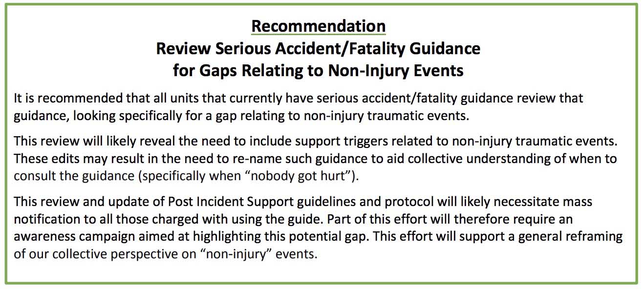
The 56-page report only has one recommendation:Recommendation horse park fire

Colorado developing drone system to enhance situational awareness

The state of Colorado is working on a system that would use drones to provide live video of wildfires to wildland firefighters’ cell phones. The Center of Excellence for Advanced Technology Aerial Firefighting is beta testing a DVI Mavic drone that would push the real time video to firefighters using software developed by the military, Android Team Awareness Kit (ATAK).

The program has the capability of displaying data from tracking devices carried by soldiers, or firefighters, and identifying their location on a map, which in this case could also show the fire in real time.

If they are successful in developing and implementing a system that can provide to fire managers real time information about the location of a wildfire AND firefighting resources, it would achieve what we call the Holy Grail of Wildland Firefighter Safety — knowing those two elements of information.

The DJI Mavic can only stay in the air for 20 to 30 minutes before having to return to base to replace the battery. So this beta test is probably only a proof of concept attempt, perhaps leading to a more robust drone, rotor or fixed wing, that could stay in the air for a much longer period of time.

Colorado's Pilatus PC12 N327F
“https://wildfiretoday.com/wp-content/uploads/2017/06/PilatusPC12.jpg”> One of the two State of Colorado’s Pilatus PC12’s, was photographed in March of 2016 in Sacramento.[/captio
Colorado already has the ability to transmit near real time imagery of fires from their two MultiMission Aircraft, Pilatus PC12’s. They are integrated with the Colorado Wildfire Information System, a geospatial database that displays incident images and details to local fire managers through a web based application.

Tornado observed near Weston Pass fire in Colorado

Tornado Weston Pass Fire
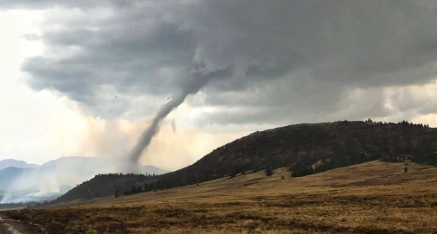
Tornado near the Weston Pass Fire. Photo by Wellington Fire Department, @WellingtonFire1.

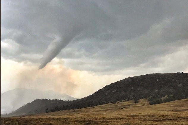
Wildland firefighters have enough to worry about,  but Thursday a tornado briefly touched down just south of the Weston Pass Fire, then while receding back into the cloud it moved directly over the fire.

Tornadoes are very rare in this part of the country. According to the National Weather Service office in Boulder, it was the 6th confirmed tornado in Park County since records began in 1950.

Chief Meteorologist/Climatologist for 11 News in Colorado Springs, said “No, this isn’t a firewhirl, it is a legit tornado produced by a thunderstorm that moved across the Weston Pass Fire.”

The Weston Pass Fire has burned about 13,000 acres 9 miles southwest of Fairplay, Colorado.

Tornado Weston Pass Fire
Tornado near the Weston Pass Fire. Photo by Wellington Fire Department, @WellingtonFire1.

Thanks and a tip of the hat go out to Jason.
Typos or errors, report them HERE.

Evacuations ordered for Lake Christine Fire at Basalt, Colorado

Tracer rounds used at a shooting range started the fire, officials said

Above: The Lake Christine Fire, Wednesday night. Photo: Katie Baum Hueth, Eagle County Sheriff’s Office.

(UPDATED at 8:19 a.m. MDT July 5, 2018)

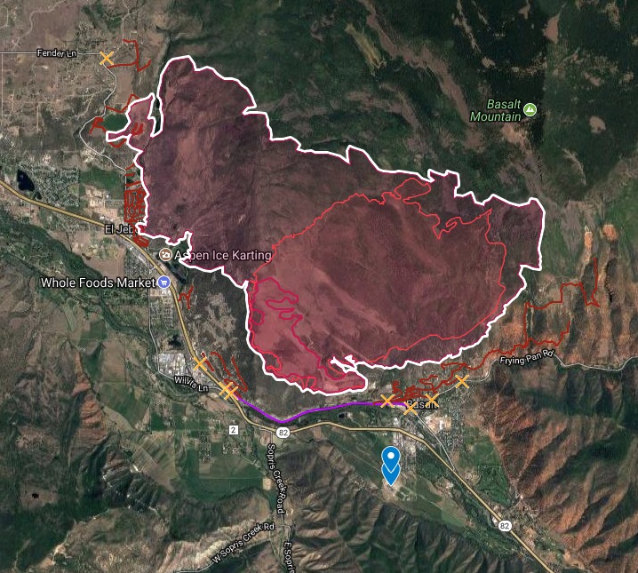
Mandatory evacuations are in effect in several locations for the Lake Christine Fire that is burning between Basalt and El Jebel, Colorado 15 air miles southeast of Glenwood Springs.

The fire started July 3 from tracer ammunition being used by shooters near Basalt.

Fire officials estimated Thursday morning it has burned approximately 4,900 acres.

map lake christine fire
Map showing the location of the Lake Christine Fire between Basalt and El Jebel, Colorado, updated at 9:45 a.m MDT July 5, 2018.

Below is a time-lapse showing the growth of the fire on July 4.

Continue reading “Evacuations ordered for Lake Christine Fire at Basalt, Colorado”

Spring Creek Fire becomes third largest in state history

It has burned approximately 94,093 acres, displacing the High Park Fire for the number three position.

Above: A DC-10 drops retardant on the Spring Creek Fire. Undated photo by Garfield County Sheriff’s Office.

(UPDATED February 21, 2019)

The Spring Creek Fire ultimately burned 108,045 acres and 141 homes, becoming the third largest in the recorded history of Colorado. A Danish man living in the United States on an expired visa was charged with 141 counts of first-degree arson for allegedly starting the fire — one charge for each of the homes destroyed.


(UPDATED at 12:37 p.m. MDT July 5, 2018)

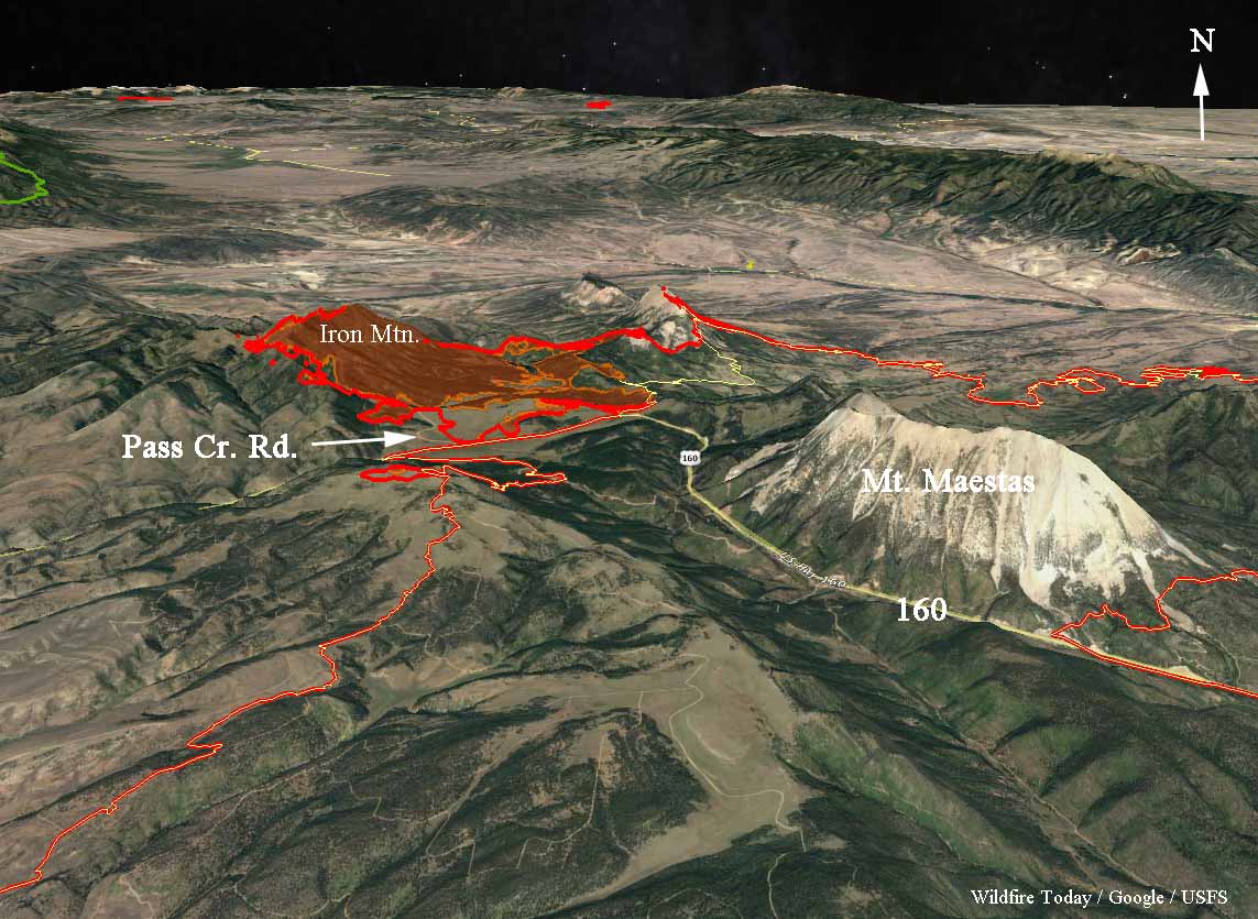
The Spring Creek Fire was very active Wednesday and Wednesday night spreading in a direction we have not seen very often since the fire started June 27. It spread rapidly on the northwest side running two to four miles west of Pass Creek Road working its way up Iron Mountain. It is unknown how far it may have continued after reaching the top. Clouds made it difficult to get good infrared data in that area.

The fire has burned approximately 103,000 acres as of early Thursday morning.

map spring creek fire
3-D map of the northwest section of the Spring Creek Fire, looking north, showing data from 12:46 a.m. MDT July 5, 2018.

Here is the outlook provided by the Incident Management Team:

Atmospheric moisture will continue to increase through the end of the week. However, given the current fuel conditions, the fire will continue to follow heavy continuous fuels to the north towards Gardner, the northeast towards Badito, to the east towards Three Bridges, to the south towards Cuchara and Indian Creek regardless of general wind direction. Potential for scattered thunderstorm activity which can cause gusty outflow winds in any direction.


(Originally published at 8:11 a.m. MDT July 4, 2018)

The Spring Creek Fire in southern Colorado between La Veta and Fort Garland added another 15,000 acres Tuesday to become the third largest in the recorded history of the state after Tuesday night’s mapping estimated that it has burned approximately 94,093 acres. A partial cloud cover made 100% precision impossible.

The five largest:

  1. Hayman Fire in 2002, 137,760 acres, NW of Colorado Springs
  2. West Fork in 2013, 110,405 acres, Wolf Creek Pass
  3. Spring Creek in 2018, 94,093 acres (preliminary mapping, still spreading) La Veta
  4. High Park Fire in 2012, 87,284 acres, west of Ft. Collins
  5. Missionary Ridge Fire in 2002, 71,739 acres, Durango

CLICK HERE to see all of the articles on Wildfire Today about the Spring Creek Fire.

Continue reading “Spring Creek Fire becomes third largest in state history”

Maps of Spring Creek Fire, July 3, 2018

Above: 3-D map of the Spring Creek Fire looking northwest.

(UPDATED at 12:57 p.m. MDT July 3, 2018)

The area where the Spring Creek Fire is located in south-central Colorado is under a Red Flag Warning today. At around noon a weather station near La Veta was recording temperatures in the mid-eighties, 9 percent relative humidity, and winds out of the west at 15 mph. On Wednesday the conditions should be similar, but with slightly higher humidity.

Tuesday afternoon the Incident Management Team changed their reported  size of the fire to 78,941 acres — up from 60,710 earlier today.


(Originally published at 8 a.m. MDT July 3, 2018)

The Spring Creek Fire is burning homes and devastating tens of thousands of acres of private land 17 miles west of Walsenburg, Colorado. San Luis Valley 911 tweeted Monday night that 104 homes have been destroyed in the Forbes Park area.

Since it started June 27 it has blackened 60,710 acres, according to the official information from the Incident Management Teams Monday night. Our VERY UNOFFICIAL estimate is that at least 75,000 acres have burned as of early Tuesday morning.

CLICK HERE to see all of the articles on Wildfire Today about the Spring Creek Fire.

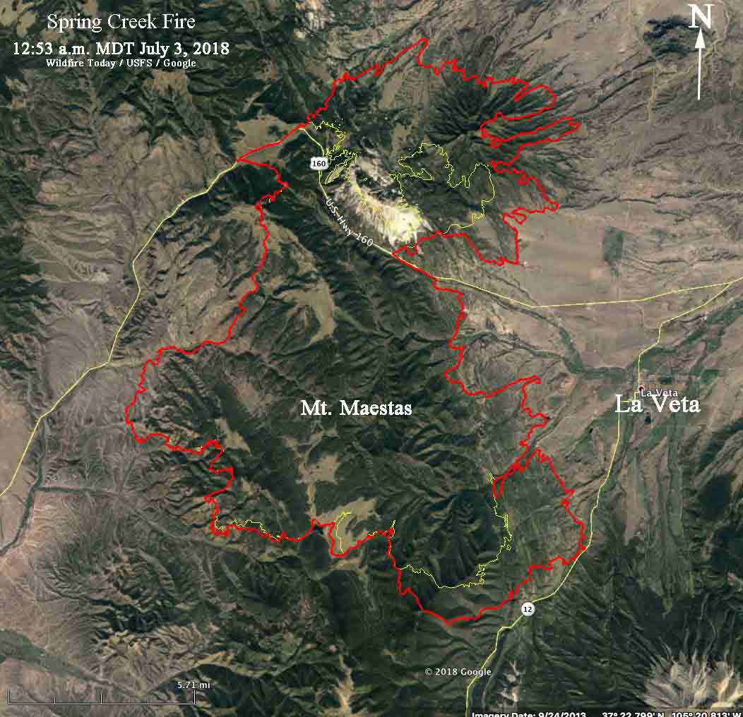
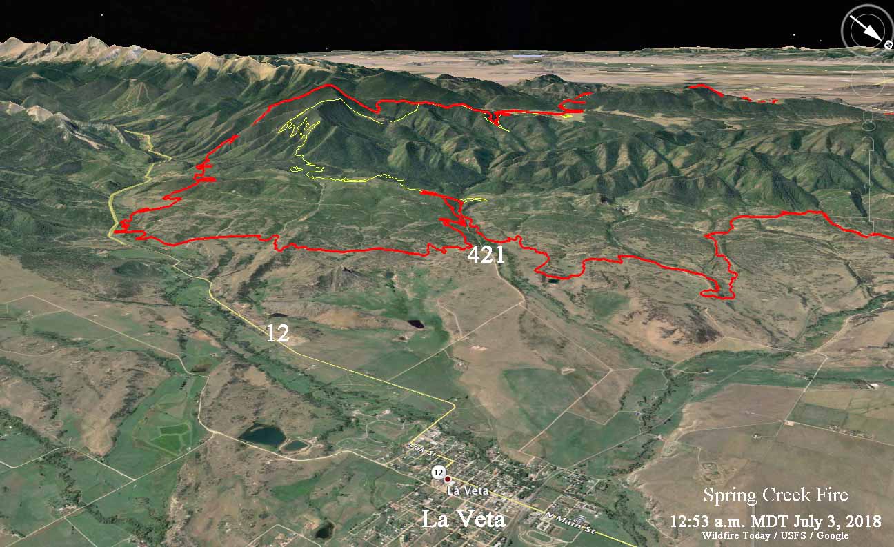
These maps were made with Google Earth using fire perimeter data collected at 12:53 a.m. MDT July 3, 2018 (the red line) by a U.S. Forest Service mapping aircraft. The yellow line was the perimeter about 24 hours before.  We hope they will answer a few questions for local residents about which areas are within the burned perimeter. Of course if they are, it does not mean that the structures have been destroyed. Firefighters have no doubt worked hard to save many.

map Spring Creek Fire
Map of the Spring Creek Fire.
map Spring Creek Fire
3-D map of the Spring Creek Fire looking southwest.

Continue reading “Maps of Spring Creek Fire, July 3, 2018”