
Drought Monitor, February 10, 2015

The Predictive Services section at the National Interagency Fire Center has issued their Wildland Fire Potential Outlook for February through May. The data represents the cumulative forecasts of the eleven Geographic Area Predictive Services Units and the National Predictive Services Unit.
If their predictions are accurate, the midwest should experience higher than normal wildfire activity from March through May, while most of the southeast should be slower than normal through May.
Here are the highlights from their outlook.
February

March

April through May

As a bonus, here is NOAA’s monthly drought outlook.
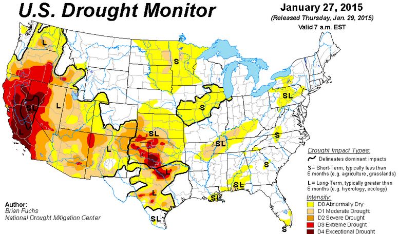
 And, the Drought Monitor for the 48 contiguous states:

New research shows that the most significant current threat to western dry forests is from insect outbreaks and droughts, not wildfires; and historically abundant small trees offer the greatest hope for forest survival and recovery after these events. Dry forests are low-elevation western forests with tall pines. The study used government records of insect and wildfire damage to compare current threats to dry forests and used records from land surveys conducted in the late-1800s to understand how dry forests persisted for thousands of years in spite of insect outbreaks, droughts, and fires. These forests persisted, this study suggests, by having both young and old trees that together provided bet-hedging.
Data on recent threats to dry forests used government maps of insect outbreaks and wildfires from 1999-2012 across 64 million acres of western dry forests or 80% of the total dry-forest area. “When comparing the rates of insect outbreaks and wildfire over the past fourteen years, we were surprised to discover insect outbreaks impacted 5 to 7 times the area that wildfire did.” said Dr. Mark Williams, a co-author of the study and recent PhD graduate of the University of Wyoming’s Program in Ecology. “In contrast, restoration efforts to increase resilience of dry forests to changing climate focus primarily on threats from wildfire. Our work suggests that impacts from insect pests should be considered with greater weight when formulating restoration prescriptions.”
To understand how forests were resilient to multiple disturbances in the past, the researchers utilized historical data which included 45,171 tree sizes measured along 13,900 section-lines traversed by land surveyors in about 4.2 million acres of dry forests in Arizona, California, Colorado, and Oregon in the late-1800s.
“The late-1800s land surveys provide us with a spatially extensive and detailed view of how these dry forests persisted through unpredictable episodes of insect outbreaks, droughts, and wildfires” said Dr. William Baker, a co-author of the study and Professor Emeritus in the Program in Ecology and Department of Geography at the University of Wyoming. “What we see from the surveys is that dry forests historically had many large trees, that often survived wildfires, but even more small trees that were less prone to be killed during insect outbreaks and droughts. The combination of abundant youth and older trees provided bet-hedging insurance that allowed these forests to survive and recover regardless of whether an insect outbreak, drought, or wildfire occurred. These unpredictable events may increase with global warming.”
The study’s findings suggest current programs that remove most small trees to lower the intensity of wildfires in dry forests and restore large trees lost to logging, may reduce forest resilience to the larger threats from insect outbreaks and droughts. “Using historical forests as a guide, our study suggests we may want to modify our restoration and management programs so they do not put all our eggs in one basket, but instead hedge our bets by keeping both large trees and abundant small ones” said Dr. Baker.
Key findings:
The study was published Open Access online in the international scientific journal, Frontiers in Ecology and Evolution and is freely available to download on their website.

According to the January 13, 2015, U.S. Drought Monitor, moderate to exceptional drought covers 28.0% of the contiguous United States, a slight decrease from last week’s 28.1%. The worst drought categories (extreme to exceptional drought) also remained nearly unchanged, covering around 8.8% of the lower 48 states.
From Bloomberg:
California’s worst drought in four decades, which has threatened agriculture and exacerbated wildfire risk, has been driven primarily by natural atmospheric patterns, according to a U.S. government-sponsored study.
A recurring high-pressure ridge off the West Coast influenced by varying sea surface temperatures blocked wet-season storms over the past three years, causing the least winter precipitation since 1974-1977 for the world’s eighth-largest economy, according to the report released today.
The study was conducted by researchers at Columbia University’s Lamont Doherty Earth Observatory and International Research Institute for Climate and Society and at NASA and theNational Oceanic and Atmospheric Administration, which sponsored the work.
While models project that the southwestern portion of North America as a whole will become more arid because of rising greenhouse gas emissions, determining the impact of human-induced climate change from the observational record is difficult, they concluded.


The Drought Monitor from August 19 (above) and the map from three months ago (below).

Alkali Fire in Moffat County grows to 20,000 acres. http://t.co/bCq4G0c6VX Photo courtesy @craigdailypresspic.twitter.com/pocjl0wJIj
— CPR News (@NewsCPR) July 24, 2014
The Alkali fire in northwestern Colorado rapidly burned 20,000 acres in less than 24 hours as of Thursday, and remains the only sizable wildfire to hit the state this fire season.
The fire was discovered north of Maybell around 2:30 p.m. on Wednesday, 9News in Denver reported. The cause remains under investigation. Thus far, the fire has not prompted mass evacuations, but it has destroyed a part-time home and barn and killed three cattle.
It’s been a remarkably quiet fire year for Colorado following two back-to-back years of devastating wildfires in the state. In 2012, the Waldo Canyon fire burned 347 homes in western Colorado Springs, while the Lower North Fork and the High Park fires in Northern Colorado burned hundreds of homes and thousands of acres.
The destruction of that summer was only surpassed by the Black Forest fire in 2013, which destroyed 486 homes east of Colorado Springs and burned under 16,000 acres.
Like much of the west for the past decade, Colorado has been plagued by drought until this year. Torrential rains in September 2013, while killing 10 people and causing massive flood damage statewide, gave the state a much needed reprieve from tinder-dry conditions.
There are a few areas of the state that are still abnormally dry, including Moffat County, in the state’s northwestern-most corner.


The Drought Monitor released on Thursday shows a worsening condition in many of the states in the western and central part of the country, including California, Oregon, Nevada, Arizona, New Mexico, Texas, Kansas, Nebraska, South Dakota, Washington, and Oklahoma.
Below is the Drought Monitor map released on February 20, 2014:


Yesterday the latest version of the drought monitor for the United States was released, current as of February 18. Below is the description:
****
“During the past week, a persistent pattern of ridging (high pressure) over the Southwest and troughing (low pressure) over the East prevailed. Unfortunately, the ample moisture that finally visited drought-ravaged California (especially north-central sections) last week was shunted northward by the southwestern ridge into the Pacific Northwest this period, dumping widespread precipitation totals of 4-8 inches, locally 12-18 inches, from extreme northwestern California into western Washington. Additionally, the precipitation was accompanied by mild air, producing mainly rain instead of snow in southern sections of the Cascades in Oregon and limiting any snow pack increase for those mountains.
Farther north, however, the precipitation fell as snow in the northern Cascades (Washington) and northern Rockies, increasing the average basin SNOTEL snow water content by 10-20 percentage points in six days (from Feb. 12 to 18). Farther east, a series of winter storms brought wintry precipitation to the Midwest (light to moderate snow), Southeast (severe icing in Georgia and South Carolina), and the Northeast (heavy snow) as cold air remained entrenched in those regions. In contrast, dry and mild weather continued in the southwestern quarter of the Nation, further degrading conditions there. In Hawaii, scattered showers continued, with Kauai and Oahu receiving the greatest totals, while Puerto Rico and most of Alaska saw light precipitation, except for moderate amounts (more than 2 inches) in the southeastern Alaskan Panhandle.”