Oklahoma: one person killed and six homes destroyed in wildfire

(UPDATED at 12:42 p.m. May 7, 2014)

The wildfire near Guthrie, Oklahoma burned approximately 3,250 acres. One
civilian fatality is attributed to this fire and an estimated 46 structures have been lost, according to Oklahoma Forestry Services (OFS). The fire has been turned back to local command with all containment lines holding through Tuesday’s weather conditions. OFS will have a Task Force with 3 dozers and 3 engines assisting with patrol and mop up on Wednesday.

****

(UPDATED at 11:57 a.m. CDT, May 6, 2014)

The wildfire near Guthrie, Oklahoma continued to be active on Monday due to strong winds and low relative humidity. The weather forecast for Tuesday is similar, predicting Red Flag conditions,  with 94 degrees, 23 percent relative humidity, and 24 mph winds gusting up to 33 mph. Tuesday morning the fire was reported to be 90 percent contained.

In the video below, Guthrie Fire Department Chief Eric Harlow provides an update on the fire. It was recorded May 5, probably late in the day, and was uploaded to YouTube on May 6. 

Despite earlier reports provided by fire officials, investigators with the Oklahoma state Department of Agriculture and the state Fire Marshall’s Office have found no evidence the fire started as a controlled burn.

****

(UPDATED at 7:15 p.m. CT, May 5, 2014)
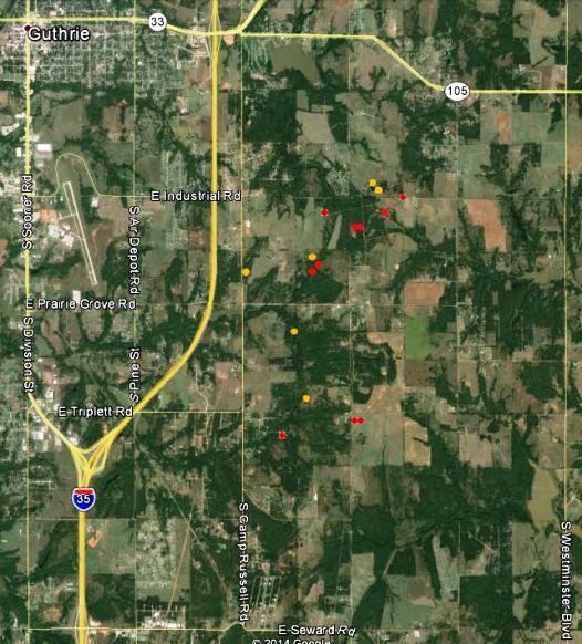
Map of fire near Guthrie, OK 250 pm CT May 5, 2014
Map of fire near Guthrie, OK, showing the approximate locations of heat detected by a satellite at 2:50 p.m. CT, May 5, 2014. The red and yellow dots represent the location of the heat.

The location of the fire is southeast of Guthrie, Oklahoma, 24 miles north of Oklahoma City, and east of Interstate 35 (map).

The local fire departments have not released information about the exact location of the origin of the fire, but they did say it started from a “controlled burn” — which could mean anything from a resident burning trash in their back yard, to a rancher burning a pasture. Google Earth did not show any indication that any federal land was in the area of the fire.

Fox23 in a Monday afternoon report said at least a dozen homes have burned and the estimated size of the fire is now 3,000 to 3,500 acres. National Guard Blackhawk helicopters worked the fire Monday.

From Fox23:

Gov. Mary Fallin visited the command post Monday, and said the US Forestry Services crews were creating fire lines and that she put in a request to get an air tanker flown to Guthrie from Arizona.

According to the Oklahoma Department of Emergency Management three National Guard Blackhawk helicopters, two single engine air tankers (SEATs), and “a Tanker 415” will be available Tuesday evening. The “Tanker 415” could be Tanker 260, Aero-Flite’s CL-415 that was reported by Wildfire Today reader Tom Wilson (in a comment below) to be relocating from Florida to Oklahoma City on Monday. Fire Aviation had an article about Tanker 260 in November.

According to state law the Oklahoma Division of Forestry is the operational lead for wildfire emergencies.

The video below, uploaded to YouTube about 3 p.m. on Monday, has views of the fire from an aircraft.


****

(Originally published at 11:52 a.m. CT, May 5, 2015)

Fire officials said a controlled burn near Guthrie, Oklahoma escaped on Sunday and killed one person and destroyed at least six homes. Guthrie Fire Department Chief Eric Harlow said the number of damaged homes was expected to rise after they are able to better assess the four to six square mile (2,560 to 3,840 acre) fire after sunrise on Monday. About 1,000 people evacuated on Sunday, but most of those have been able to return to their homes.

Chief Harlow said the 56-year old man who was killed had refused to evacuate when requested by his family and law enforcement.

On Sunday the fire was pushed by strong winds and dry conditions. The weather forecast for the Guthrie area on Monday calls for similar weather — 100 degrees, 17 to 20 mph southeast winds gusting to 28 mph, and single-digit relative humidities.

Early Monday morning Chief Harlow said:

We still have some hot spots but for the most part we do have control of this thing. I’m still going to say 75 percent containment. Three of the four sides are contained. The north side I’m not going to say is 100 percent contained yet.

He said the fire started from a controlled burn on one of two properties, but did not know exactly what the land owner had initially intended to burn.

They have requested helicopters from the National  Guard which would arrive at 11 a.m. at the earliest.

The video below is a recording of a live media briefing early Monday morning featuring Chief Harlow.

Florida: prescribed fire escapes at St. Johns National Wildlife Refuge

Saint Johns National Wildlife Refuge, map

A prescribed fire escaped at a national wildlife refuge east of Orlando on Monday. The plan was to burn 660 acres within St. Johns National Wildlife Refuge, but multiple simultaneous spot fires outside the burn unit exceeded the capability of the firefighters from Merritt Island National Wildlife Refuge who were conducting the burn. An additional 72 acres of private land and 200 acres of Brevard County property outside the refuge burned — 600 acres in the original planned unit were completed.

The escape was knocked down by 43 personnel on Monday. Today spokesperson Candice Stevenson of the U.S. Fish and Wildlife Service said the fire is 70 percent contained. Agencies involved in the suppression of the escaped fire included the U.S. Fish and Wildlife Service, Brevard County, Florida Forest Service, the City of Titusville, and the U.S. Forest Service.


Iowa prescribed fire escapes, burns private property

Burned property in Iowa
Glen Dale Geiger examines his property that burned during an escaped prescribed fire in Iowa. Photo from KCRG.

A prescribed fire conducted by the Iowa Department of Natural Resources escaped on April 12 and burned onto three nearby properties. One of the victims was Glen Dale Geiger who lost three structures containing farm equipment and his pride and joy, a 1960 convertible that burned exactly 54 years to the day after he bought it. Mr. Geiger said other equipment lost included, “My corn picker, corn planter, my baler, feed wagons, my other wagon sitting outside, my camper in the corn crib, snow blower, bicycles,”

At first the DNR said the National Weather Service gave them “the wrong forecast”, but they later backtracked from that, saying the DNR did not follow protocol in checking the weather for the site of the prescribed fire.
Thanks and a hat tip go out to Chip.

Report released on escaped prescribed fire at Devils Tower

Above: Map, showing the approximate location of the planned prescribed fire at Devils Tower (300 acres in white) and the 56 acres (in red) that escaped beyond the planned perimeter. Image from Google Earth. Perimeters by Wildfire Today.

Yesterday after Wildfire Today made inquiries about reports that may have been completed regarding the escaped prescribed fire on May 8, 2013 at Devils Tower National Monument in Wyoming, the National Park Service released the official review of the incident.

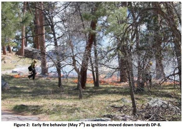
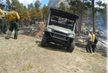
The NPS ignited the 300-acre unit on May 7, 2013. Several spot fires occurred outside the planned perimeter that were contained the first day. But during mopup at 12:50 p.m. on May 8 fire became established again at one of the spot fire locations on the southwest side of the project. At that time the cooperating U.S. Forest Service resources present the day before had been released. Some of the remaining firefighters were concentrating on the previous day’s spot fires at another location, but most of the firefighters were attending an After Action Review of a non-injury tipover of a Utility Task Vehicle (UTV) that occurred the day before. The 56 acres burning outside the burn unit were mostly stopped at the Monument boundary, but a few acres crossed over onto private land leased by Wyoming state Senator Ogden Driskill, but no structures were damaged.

Devils Tower Rx fire, May 8, 2013
Devils Tower Rx fire, May 7, 2013. NPS photo.

In the interest of full disclosure, Devils Tower was one of the seven National Parks for which I was the Area Fire Management Officer, from 1998 until 2003.

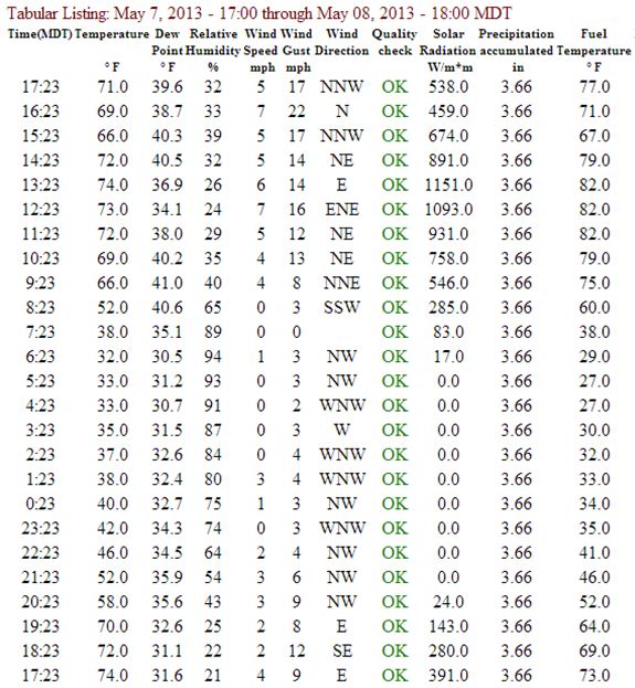
The review pointed out several times that one of the primary issues related to the escape was that in computing the fine dead fuel moisture, it was assumed that the fire would be shaded by the smoke column. However, some of the area was not shaded, and for two hours each day on May 7 and 8, at those locations the fine dead fuel moisture dropped below the 4 to 10 percent allowed in the prescription, down to 3 percent.

Other than how the weather affected the fuel moisture, the review barely mentioned the weather conditions and the forecast. Two spot weather forecasts were issued before the escape — one at 7:57 a.m. MDT on May 7 and another at 9:29 a.m. on May 8, the day of the escape. For May 8, both forecasts predicted fairly strong northeast winds, of 7 to 15 mph and 8 to 14 mph.

The Remote Automatic Weather Station at Devils Tower is very close to the location of the prescribed fire, in a low-lying area partially sheltered by trees from winds from all directions (see map above). Northwest, north, and northeast winds are additionally partially blocked by higher ground and the Devils Tower itself. Below are the weather observations from the weather station between 17:23 on May 7 through 17:23 on May 8. They show mild sustained wind speeds, with gusts around mid-day to late afternoon on May 8 of 13 to 22 mph. If the weather station was in a more exposed location the recorded speeds would have been higher.

Devils Tower weather, May 7 and 8, 2013

The NPS committed four people to the facilitated learning analysis of the non-injury slow tip over of the UTV, and three to the review of the escaped prescribed fire.

UTV at Devils Tower
Photo from the FLA for the UTV tip over, that presumably shows a UTV in the approximate location of the accident. NPS photo.

We initially covered the prescribed in 2013 fire HERE and HERE.

Weather cited as primary issue in escaped prescribed fire near Hettinger, ND

Pautre Fire origin

A report issued by the U.S. Forest Service for a prescribed fire that escaped on the Dakota Prairie National Grasslands in northern South Dakota last year cited weather as being one of the primary factors in losing control of the fire.

The Pasture 3B prescribed fire was planned at 210 acres, but strong winds on April 3, 2013 caused by the predicted passage of a cold front pushed the fire across a mowed fire line into tall grass and ultimately burned 10,679 acres, (3,519 acres federal and 7,160 acres private). The wildfire, named Pautre Fire, was stopped at 11 p.m. that night.

On April 3, 2013 we wrote about the wildfire:

An article in The Rapid City Journal has more information about the impacts of the fire on the ranchers. Privately owned grazing, hay stacks, and miles of fencing were damaged or destroyed during the ranchers’ calving season. Here is an excerpt:

“Laurie Casper, 36, said the fire destroyed 95 percent of her family’s farmland, which is more than 1,000 acres.

‘We lost all of our calving pasture, we lost our summer grazing, we lost our fall grazing, we lost 100 percent of our alfalfa— which we cut for hay bales in order to feed the cattle this oncoming winter— all that’s completely gone,’ she said. ‘And there’s just just miles and miles of fences that are completely gone.’ “

The prescription in the project’s burn plan for the maximum wind speed at eye level was 15 mph and the maximum wind speed at the 20-foot level was 20 mph. One of the spot weather forecasts for the morning of the prescribed fire predicted the passage of the cold front, with winds shifting from the south at 5 to 11 mph in the morning, to northwest at 25 mph with gusts to 30 mph in the afternoon. The actual weather that day was very similar to the forecast.

About a month later, another prescribed fire not too far away, at Devils Tower National Memorial in western Wyoming, also escaped, due partially to strong winds. That report still has not been posted on the Wildland Fire Lessons Learned Center website. We were told today that was due to a glitch, and it will appear there very soon, possibly as early as today, February 4. (UPDATE, February 5, 2014: the National Park Service arranged to have the Devils Tower report posted late in the day on February 4. We wrote about it here.)

Pautre Fire. US Forest Service photo.

The report said firefighters concluded they would not do much different next time (page 12):

Firefighters did an excellent job of planning, organizing and executing this prescribed fire and adhering to the prescribed fire plan. Following the control of the escaped fire some firefighters had difficulty thinking of anything they would do differently next time. While it is true that we work in a dangerous environment with unexpected changes in weather, we strive to be a learning culture and continuously improve our ability to make decisions that evaluate risk and get work done on the ground.

Some of the issues listed by the Facilitated Learning Analysis team included:

  • Improved weather forecasts are needed.
  • Consider additional research on methods to predict effects of drought on fire behavior in grass fuel models.
  • The nearest remote automated weather station (RAWS) is more than 90 miles away.
  • The project was conducted at the critical edge of the prescription.
  • Consider gaming out worst case scenario “what ifs” during the planning process, and discuss with participants during the on-site briefing.
  • There were problems with radio communications [note from Bill: I don’t remember EVER seeing a report like this that did not cite radio communications as being an issue].

The commendations section included this:

The personnel involved in all levels of the Pasture 3B prescribed fire were motivated, worked well as a team, were adequately trained, and appropriately briefed. They had a keen awareness that this was the first burn of the year, and took numerous precautions to ensure successful completion of the prescribed fire.

We did not see any mention in the report of damaged fences, hay, or pastures.

Some ranchers in western North Dakota donated hay to the South Dakota ranchers who lost theirs in the escaped prescribed fire.

Florida to install sensors to detect degraded visibility on highway subject to smoke and fog

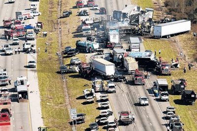
January 9, 2008 crash on Interstate 4 in Florida
The wreckage of the January 9, 2008 crash on Interstate 4 in Florida. The Ledger.

In 2008 and 2012 two massive car pile-ups on Florida Interstate highways were caused by poor visibility due to combinations of wildfire smoke and fog. A total of 16 motorists were killed in the crashes. At the location where 11 people died on I-75 in 2012 the Florida Department of Transportation will be installing sensors and warning systems to detect dangerous conditions and notify drivers of the deteriorating conditions.

Standard and infrared cameras, visibility sensors, dynamic messaging signs and vehicle detection devices will be set up south of Gainesville where I-75 crosses Paynes Prairie Preserve State Park. The infrared camera and 18 visibility sensors will monitor will measure fog, while other devices will detect moving traffic.

The equipment will be installed in a low-lying area where cold air settles, sometimes causing fog. If a vegetation fire is nearby, as was the case in both pile-ups, the mixture of fog and smoke can cause very poor visibility.

The crash in 2008 on Interstate 4 was caused by fog that combined with the smoke from an escaped prescribed fire.