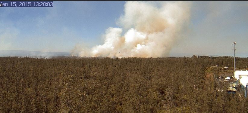
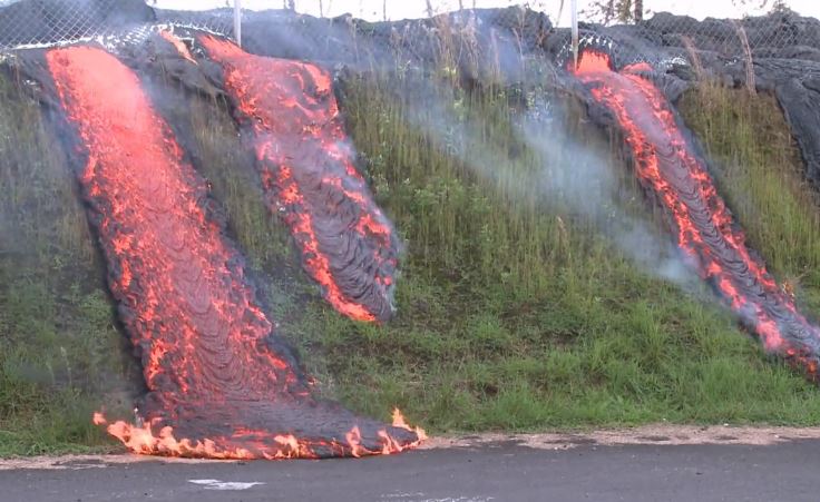
Images from the volcano eruption in Hawaii

The eruption of the volcano on the Big Island in Hawaii is certainly tragic for the owners of the 26 homes that have been destroyed and the 1,700 residents of Leilani Estates that have been forced to evacuate. We are not going to try to cover the incident like we would a large vegetation fire — primarily because it is very difficult to obtain the kind of information we would normally collect about a fire. We have made some inquiries with a couple of agencies but distributing information to the media could be pretty far down their list of priorities. They no doubt have their hands full.

But we have found a bit of information about what is going on there. Approximately 104 acres are directly affected by vents, fissures, or 2,000F-degree lava. The activity paused for a bit Monday, but Tuesday morning two additional fissures developed, bringing the total to 14 and requiring the total evacuation of  Lanipuna.

Previous eruptions on the island have ignited vegetation fires, but while we have seen some trees and shrubs burning in videos, it seems to mostly be when they are directly contacted by the molten lava.

A friend of ours has been in Hawaii for at least a week and most of the numerous photos he has posted on Facebook have shown cloudy skies. The weather Monday and Tuesday at Hilo included rain with humidities in the 90’s, so until that changes there might not be much of a wildfire threat.

If any of our readers have confirmed information about resources assigned or an Incident Command System being used, let us know in the comments.

Here is a link to a live camera.

I don’t know what Hell looks like, but….. the video below of the lava in the crater is incredible.
volcano photo
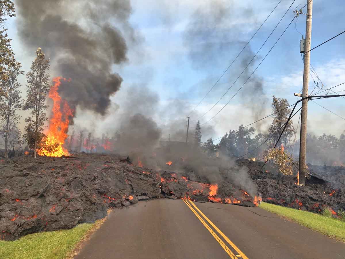
On May 5 lava from fissure 7 slowly advanced to the northeast on Hookapu Street. USGS photo.

Overflight in Leilani Estates: fissure 12 opens shortly after fissure 11 becomes inactive. Fissure 12 in the forest south of Malama Street. https://t.co/w5XLplnwVHpic.twitter.com/IdUmtORibY

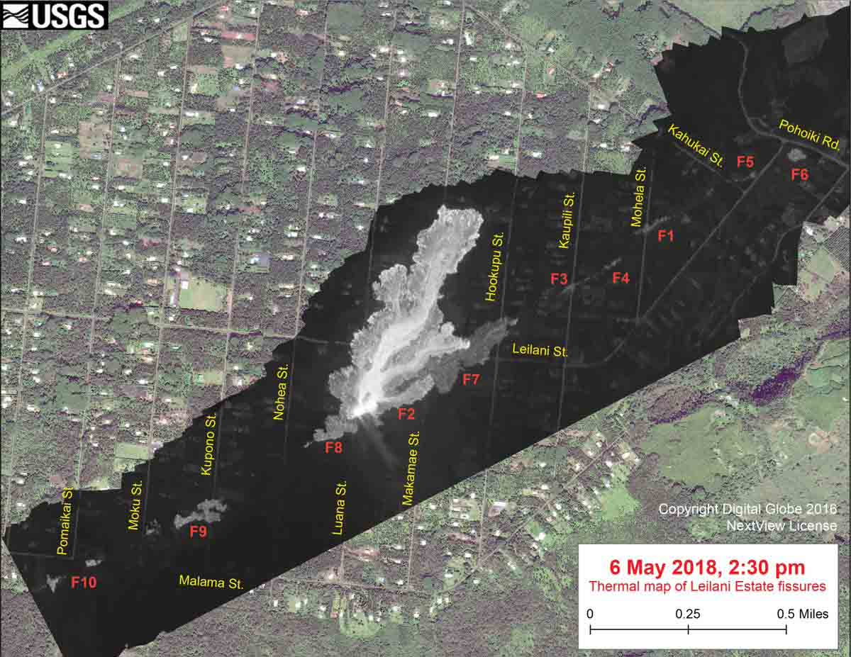
volcano May 6 map

volcano photo may 5
In the Leilani Estates Subdivision, fissure 7 was active for several hours on May 5 with large bubble bursts and spatter. A short lava flow moved northeast and crossed Hookupu St. USGS photo.

Second large wildfire in a week on Maui

From the Maui News in Hawaii:

“The second large brush fire in a week burned to within 50 to 100 feet of a home at the top of Ehehene Street in Ukumehame, shut down Honoapiilani Highway for about 30 minutes Friday evening, and blackened at least 300 acres, a Maui Fire Department official said.

Fire Services Chief Edward Taomoto said at about 8 p.m. Friday that the 300 acres burned was a conservative figure and was likely to increase overnight. The fire was not contained Friday night, he said.

This fire in the Ukumehame-Olowalu area comes as fighters have a 4,700-acre Maalaea-to-Ukumehame blaze nearly contained. Fire officials said Thursday that the fast-moving fire that began July 2 was 80 to 90 percent contained.”

****

Wildfire briefing, January 30, 2015

Fire near Lake Disston, Florida

Fire near Lake Disston FL

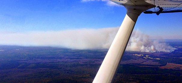
Kenny Arnaldi took this photo Wednesday of a wildfire a mile south of Lake Disston, Florida.

Bushfire burns into Waroona in Western Australia

 bushfire threatening Waroona
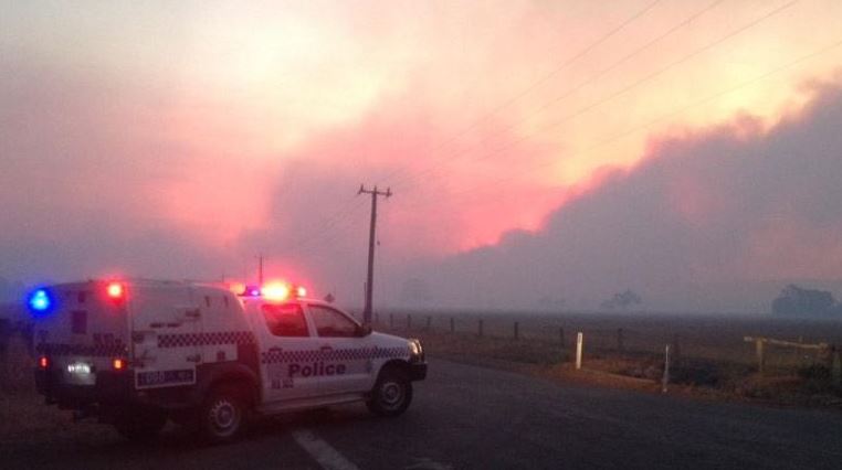
A bushfire threatening Waroona, about 100 kilometers south of Perth.

A large bushfire has burned into the city of Waroona in Western Australia about 100 kilometers south of Perth. (Map)

Below is an excerpt from an article at abc.net.au updated at about 4 p.m. MST, January 30, 2015:

An out-of-control bushfire is threatening lives and homes at Waroona in Western Australia, with up to three properties believed to be damaged so far. The blaze has entered the town, which is about 100 kilometres south of Perth, and the Department of Fire and Emergency Services (DFES) has warned it is moving fast in a north-westerly direction. Embers are likely to be blown around homes, starting spot fires.

DFES duty assistant commissioner Chris Arnol said residents should take their location into consideration when planning how to respond.

“It depends on where they are. We’ve asked some residents to shelter in place which is the best option for them and others to evacuate to [an evacuation centre in the nearby town of Harvey],” he said. “People should have their fire plans ready and know what to do. We’ve got about 150 firefighters. We had 21 appliances on the fire and we’ve sent a further 24 from the metropolitan area.”

Oklahoma grass fires

Firefighters responding to a fire southwest of Tulsa observed a person setting one of eight grass fires that were burning in the area. More information is in the video below.

Update on the Kīlauea volcano lava flow
Kīlauea volcano
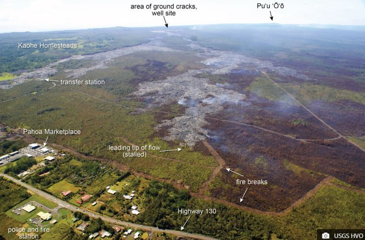
The image above released by US Geological Survey Hawaiian Volcano Observatory on January 29 shows the lava flow front from the Kīlauea volcano a mere 550 yards away from Highway 130 at its closest point. The distal tips are stalled, however “breakouts persist upslope,” writes USGS, “and these areas of activity can be spotted in this photograph by small smoke plumes where the lava is burning vegetation on the flow margins.”

Mississippi wildfire threatens natural gas facilities
A wildfire in Simpson County Mississippi (map) burned over an underground natural gas pipeline and came close to an above ground gas substation.

Below are excerpts from an article at WSMV:

“If it blows up down here, won’t nobody be left in Simpson County,” said resident Gurston McDonald.

McDonald lives just down the road from where a fire ripped through several acres of grass and forest, stopping just a few feet shy of a natural gas substation.

“All these gas lines coming through is a great concern,” added McDonald.

Simpson County EOC Director Glen Jennings said at least three fires broke out Thursday afternoon. However, the one off the highway posed the biggest danger to neighboring residents. Containing it also remained a challenge, because forestry officials can’t dig a fire line when there’s a gas line underneath.

“We don’t push on these gas lines. We just let it go, try to control it by water or some other means,” said Ben Vanderford with the Mississippi Forestry Commission. “We never know how deep those lines are, when we’re out there plowing these fire lines. These lines may be five or six feet under the ground, they might be five or six inches under the ground.”

And as night fell, flames spread again toward the substation, this time from a patch of trees about 200 feet away, with no fire line to stop it.


Volcano in Hawaii continues to ignite fires

Hawaii volcano brush fire
Vegetation fire ignited by the Kīlauea volcano in Hawaii, January 15, 2015. Photo from the Hawaii Volcano Observatory.

In addition to the 270 acres that burned earlier in the week, the Kīlauea volcano in Hawaii ignited fires in two more areas on Thursday that burned about 350 acres by the end of the day. The fires were west of Highway 130, 0.6 to 0.9 mile from the Aina­loa subdivision.

Two  dozers were at the scene improving fire breaks along with two helicopters dropping water.

Hawaii County Assistant Fire Chief Gantry Andrade said the fires would likely be under control by Friday.

A web cam operated by the Hawaii Volcano Observatory at the Pāhoa Marketplace occasionally grabs images of smoke from the lava-ignited fires.

Kīlauea volcano in Hawaii brush fire
Aerial photo taken January 13 showing a vegetation fire ignited by the lava flow from the Kīlauea volcano in Hawaii. Note the fire break, which was overrun by the lava.

Wildfire briefing, January 14, 2015

Hawaii’s Kīlauea volcano lava ignites brush fire

A lava flow from the Kīlauea volcano in Hawaii ignited a brush fire on Tuesday that burned 270 acres. It was surrounded by fire breaks, but at 5:30 p.m. local time a dozer was working to clean up the existing break and construct a new line closer to the head of the fire. According to a Hawaii County Civil Defense update, the brush fire was west of Highway 130, about 1.5 miles from the Aina­loa subdivision. The agency said Tuesday afternoon that neither the brush fire nor the stalled lava flow pose an immediate threat to communities.

Granite Mountain Hotshots’ families treated to European boat trip

From the Daily Courier:

The families of Prescott’s fallen [Granite Mountain] Hotshots participated in a unique trip over the holidays. They were given an opportunity to see and visit the historic sites along Europe’s Danube River while finding solace amongst others who also have experienced the tragic loss of loved ones in recent U.S. tragedies.

Family members of the Hotshots were joined by family members of the victims of the 9/11 tragedy and the 2013 Boston Marathon bombing. The 19 Granite Mountain Hotshots died battling the Yarnell Hill wildfire on June 30, 2013 in the worst wildland firefighting tragedy in more than 80 years…

The paper said 19 family members participated in the trip.

News from Australia:

Lava continues to spread from Hawaii volcano

Kilauea volcano lava
Lava from the Kilauea volcano in Hawaii spreads through a fence, down an embankment, and onto a parking lot. Screen capture from County of Hawaii video.

Lava from the Kilauea volcano has advanced onto a parking lot of the Pahoa Transfer Station on the Big Island in Hawaii. West Hawaii Today has more information, including a video.