Officials say 207 homes destroyed in McBride Fire in New Mexico

Two people were found deceased at a home inside the fire perimeter

Updated at 10:20 a.m. MDT April 16, 2022

McBride Fire, New Mexico April 16, 2022
McBride Fire, Ruidoso, New Mexico. Posted by the Incident Management Team April 16, 2022.

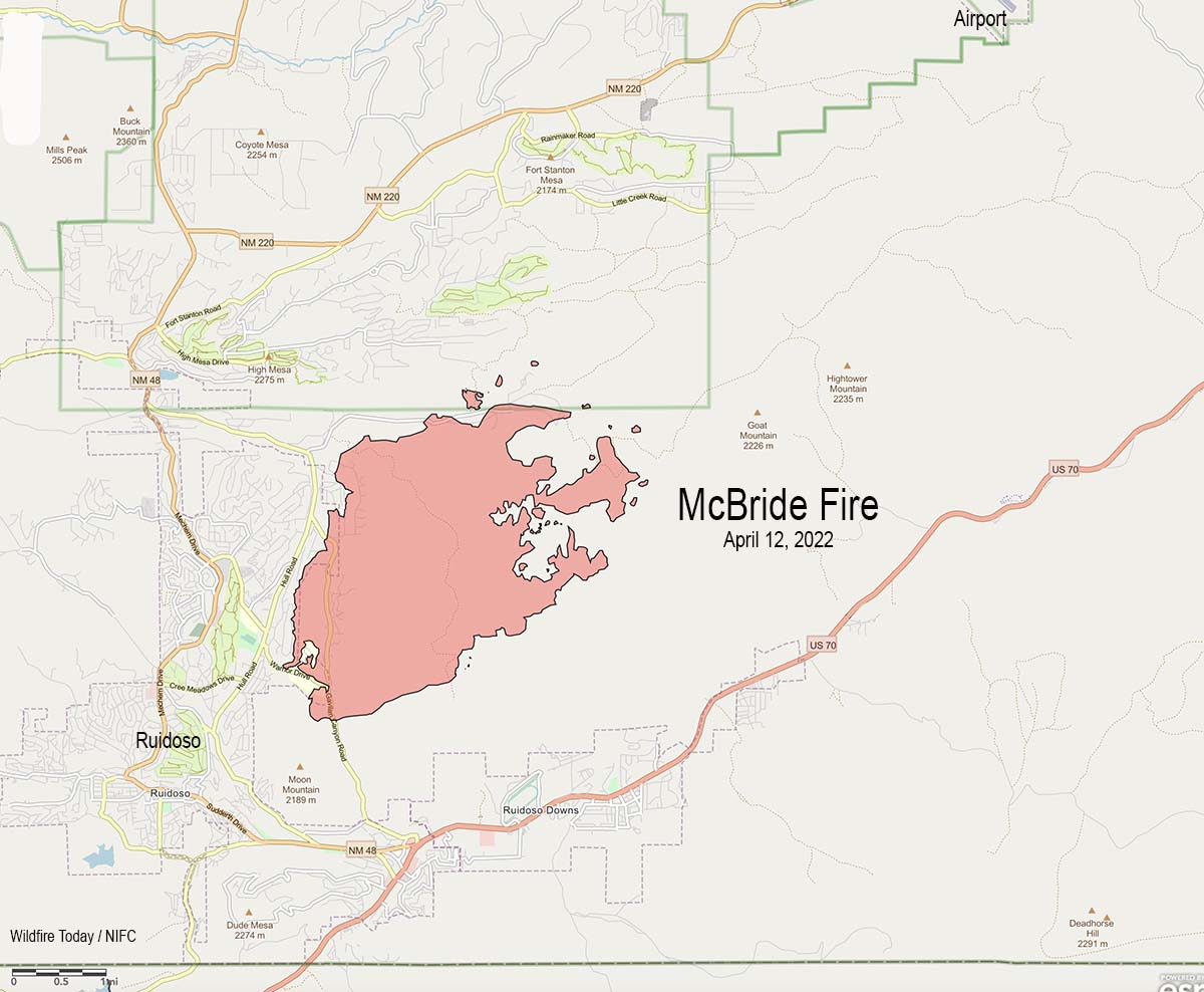
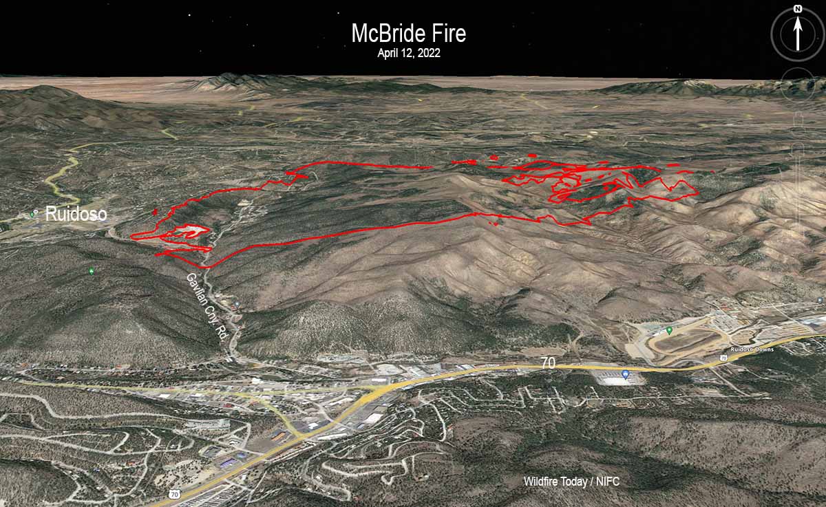
The perimeter of the McBride Fire at Ruidoso, New Mexico did not change in any significant way Friday, even as a few pockets of vegetation in the interior burned, putting up occasional bursts of smoke. Firefighters have been mopping up to further secure the fire’s edge. Dozers and ground crews are working on the north side in the rugged, tough country in the Eagle Creek area. On the east edge where the fire is burning in old fire scars, crews are scouting for potential control lines, such as old two track roads.

Some evacuations have been lifted, but others remain in place. The list, updated once or twice a day, is posted online.

The Incident Status Summary filed Friday evening shows resources working on the fire include 5 hand crews, 23 fire engines, and 3 helicopters. In a Saturday morning briefing the Information Officer said a total of 299 personnel were assigned. The number of homes destroyed remains at 207.


Updated 8:28 a.m. MDT April 15, 2022

Map McBride Fire 8:15 p.m. April 14, 2022
Map showing the perimeter of the McBride Fire (in red) at 8:15 p.m. April 14, 2022. The black line was the perimeter about 24 hours before.

The McBride Fire at Ruidoso, New Mexico grew by about 300 acres Thursday and was mapped that night at 6,162 acres. The changes in the perimeter, some of which could be attributed to more accurate mapping or tactical burning operations, were on the southeast side north of the intersection of Gavilan Canyon Road and US 70 and on the northeast side near Eagle Creek Canyon Road.

Again on Thursday, more moderate winds allowed helicopters to assist firefighters on the ground by dropping water. Crews worked on constructing or securing fire lines on the east and south sides. On the northeast side dozers worked with firefighters to construct fire line. Crews put out any remaining hotspots on the southwest side, focusing on the areas where structures were damaged or destroyed.

Resources assigned to the McBride Fire Thursday evening according to the National Situation Report and the Incident Status Summary report, included 1 hand crew and 15 fire engines, for a total of 138 personnel. The report showed no helicopters even though Incident Commander Dave Bales said in a Thursday afternoon briefing that helicopters had been dropping water.

The Nogal Canyon Fire which is being suppressed by the same Incident Management Team is burning on the Lincoln National Forest 12 miles northwest of Ruidoso, southwest of Nogal. Thursday afternoon officials said it had burned 394 acres, an increase of 49 acres in 24 hours. About 65 personnel are assigned that blaze.


Updated 9:45 a.m. MDT April 14, 2022

McBride Fire perimeter at 7:30 p.m. April 13, 2022 fire history
McBride Fire perimeter (in red) at 7:30 p.m. April 13, 2022. Seen also are fires from 2011 and 2000.

The McBride Fire at Ruidoso, New Mexico spread further to the northeast Wednesday, burning an additional 300 acres on the north side of  Eagle Creek Canyon Road.

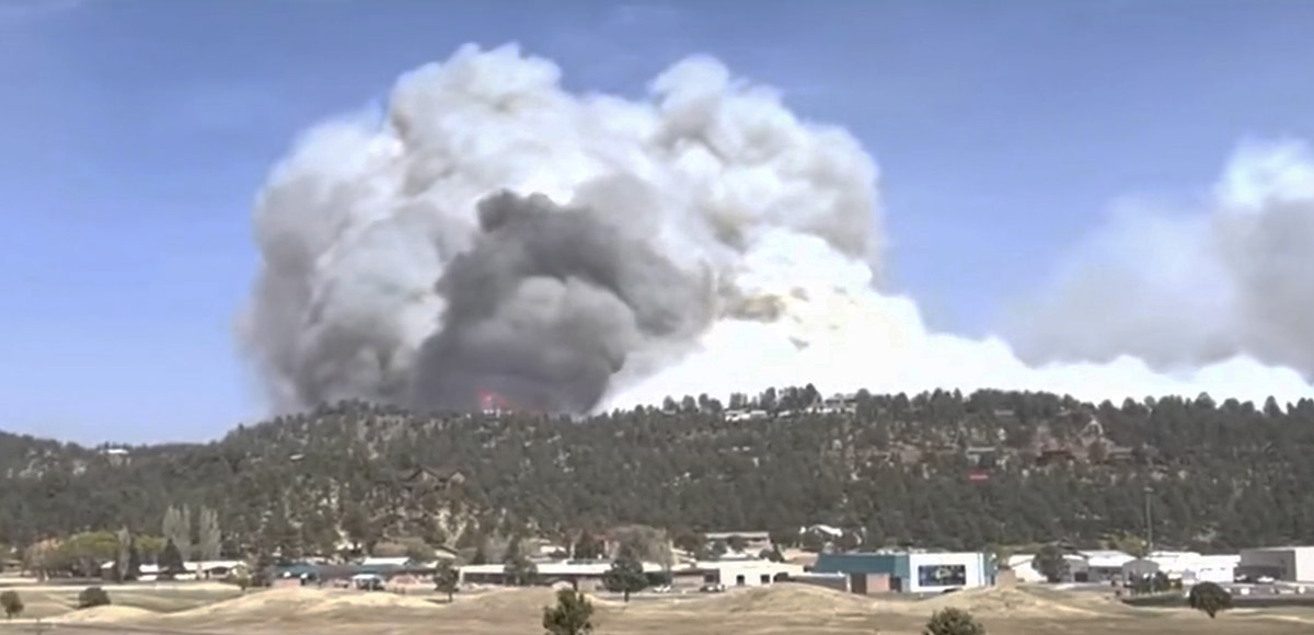
Thursday morning fire officials said the 5,736-acre fire has destroyed 207 homes. That number does not include outbuildings. Tuesday night, just hours after the fire started, officials said structures were lost in the areas of McBride, Gavilan Canyon, Fawn Ridge, Homestead Acres, and Lower Eagle Creek.

An elderly couple was found deceased at a home on Gavilan Canyon Road in Ruidoso on Tuesday. Law enforcement personnel found the couple after a report from a family member that they were unaccounted for.

Continue reading “Officials say 207 homes destroyed in McBride Fire in New Mexico”

McBride Fire starts near Ruidoso, NM as winds were gusting over 70 mph

Burned thousands of acres in the first few hours

Updated at 9:02 a.m. MDT April 13, 2022

Map, McBride Fire April 12, 2022
Map, McBride Fire April 12, 2022. (the time is uncertain)

The Incident Management team’s latest update on the McBride Fire was Tuesday night at 9 p.m. At that time the size was listed at 4,138 acres. Approximately 150 structures have burned.

The blaze spread very rapidly after it started Wednesday afternoon. The fire behavior was described by firefighters as extreme, with crowning and spotting as it burned to the northwest through timber and grass.

To see all articles on Wildfire Today about the McBride Fire, including the most recent, click HERE.

Mandatory evacuations are in place for the area around Moon Mountain, McBride/Snowcap/Timberline, Eagle Creek, Homestead Acres, Rancho Ruidoso Valley Estates, Deer Valley, Deer Park, and Alto east of Flute Player. The Ruidoso Convention Center is accepting evacuees. More evacuations are possible. The Lincoln County Fairgrounds, Roswell Animal Shelter, and Otero Fairgrounds are open for those who need to evacuate with livestock.

3-D Map, McBride Fire, April 12, 2022
3-D Map, McBride Fire, April 12, 2022. Looking north.

The area is under a Red Flag Warning again on Wednesday. The spot weather forecast for the McBride Fire issued at 1:40 a.m. on Wednesday, said, “The ongoing light precipitation will end in the next 3 hours with no accumulation expected.” On Wednesday it will be sunny. The winds will be out of the west at 16 mph with gusts to around 31 mph, with a minimum humidity of 6 percent. Wednesday night will see no humidity recovery with a maximum of 16 percent and 10 to 14 mph winds gusting to 26 out of the southwest and west. Thursday should bring west winds of 7 to 14 mph with 7 percent relative humidity.

A Type 1 Incident Management Team, Southwest Team #2, is mobilizing.


Updated at 8:15 p.m. MDT April 12, 2022

The Village of Ruidoso released an update on the McBride Fire at 7 p.m. Tuesday:

An air attack update has decreased the estimated acreage to 3,000. At this time 150 homes and structures have been lost. This is an active fire and is at 0% contained.

A mandatory evacuation notice is in order for Moon Mountain, Gavilan Canyon, Hull Road and Paradise Canyon. If you live in those areas please evacuate to the Ruidoso Convention Center. Mandatory evacuations are already in place for Eagle Creek, Homestead Acres, Rancho Ruidoso Valley Estates, Old Fort Stanton Road, and Airport Road. More evacuations are possible.

The Ruidoso Convention Center is open and the Red Cross is on site to assist those who have evacuated. The Lincoln County Fairgrounds are currently full but the Roswell Animal Shelter and Otero Fairgrounds are open for those who need to evacuate with livestock.

Crews were able to knock back the fire near the Ruidoso Middle School and evacuate 1,700+ students in 1.5 hours from Ruidoso High School, Ruidoso Middle School and Elementary Schools to the Ruidoso Convention Center. Ruidoso Municipal Schools have cancelled school for Wednesday, April 13, 2022.


6:53 p.m. MDT April 12, 2022

map Satellite image smoke McBride Fire at 5:11 p.m. MDT April 12, 2022 New Mexico
Satellite map showing smoke from the McBride Fire at 5:11 p.m. MDT April 12, 2022. NOAA.

After the McBride Fire started near McBride Drive in Ruidoso, New Mexico at approximately 2:30 p.m. April 12 it spread very rapidly pushed by winds recorded at the nearby Smokey Bear weather station at 40 mph sustained, gusting at one point to 80 mph. The winds all day in Ruidoso have been out of the southwest and the relative humidity in the afternoon dropped to 19 percent.

There are reports of multiple structures having been destroyed.

At 5 p.m. the Lincoln National Forest said on their Twitter account that it had spread to 15,000 acres and “Ruidoso residents N of Ruidoso High School need to evacuate immediately.” Specifically, areas being evacuated include Gavilan Canyon Road, Homestead Loop, Eagle Creek, Blue Lake Drive, Mira Monte Road, and east of Fort Stanton Rd. The Ruidoso Convention Center is accepting evacuees. (Later that 15,000-acre figure was reduced to 3,000 acres.)

map firefighting aircraft orbits over the McBride Fire in New Mexico
A firefighting aircraft orbits over the McBride Fire in New Mexico at 6:22 p.m. MDT April 12, 2022. ADSB Exchange map.

The fire has been spreading to the northeast toward the Sierra Blanca Regional Airport.

The local power company, PNM, shut off the electricity to 18,400 customers because the fire was moving toward a transmission line.

Within a few hours after the fire started a Type 1 Incident Management Team used for the most complex emergency incidents was ordered. It is very rare for this type of team to be requested a few hours after a fire is first reported.

With 40 mph winds gusting to more than 70, helicopters and fixed wing firefighting aircraft can’t be used safely or effectively. A small twin engine aircraft has been orbiting the fire at 17,000 feet providing intelligence and looking for opportunities to engage the fire.

McBride Fire
McBride Fire. From Melissa Gibbs KRQE video April 12, 2022.

Another fire that started on Tuesday, the Nogal Canyon Fire, is also burning on the Lincoln National Forest 12 miles northwest of Ruidoso, southwest of Nogal. Judging from heat detected by satellites it is spreading rapidly. The Forest Service said at about 4 p.m. Tuesday that all of Nogal Canyon was under an evacuation order.

Thanks and a tip of the hat go out to Tom.