Little Valley Fire burns structures northwest of Carson City, NV

In the hours before the fire was reported, wind gusting at 87 mph was recorded at a nearby weather station.

(UPDATED at 11:35 p.m. PDT October 14, 2016)

At 9:30 p.m. Washoe County updated the number of structures burned — 22 homes and 17 outbuildings. The fire has blackened 3,455 acres.
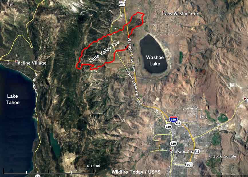
Map Little Valley Fire
Map of the Little Valley Fire at 9:23 p.m. PDT October 14, 2016.

****

(UPDATED at 3:24 p.m. PDT October 14, 2016)

Washoe County reported at 2:45 p.m. Friday about the Little Valley Fire:

Everyone who lives on the east side of Washoe Lake or the east side of I-580 can return home.

Evacuations for residents of the Galena, Montreaux, Joy Lake Rorad, and St. James neighborhoods can return home but need to be prepared to evacuate throughout the weekend if need be.

The west side of Washoe Lake from Bowers exit to the bottom of Franktown Rd. remains evacuated. Several local hotels are offering discounted room rates for those displaced by Friday’s fires.

A weather station near the fire recorded 0.10 of rain after 11 a.m. today. The relative humidity has increased to 83 percent but the wind is still strong, 14 mph gusting to 34 mph. Radar showed light rain in the area at 3:24 p.m. on Friday.

@TMFPD is the Twitter account for the Truckee Meadows Fire Protection District.

****

(Originally published at 1:16 p.m. PDT October 14, 2016)

Dozens of structures have burned in the Little Valley Fire 6 miles northwest of Carson City, Nevada and 17 miles south of Reno. It was reported at 2 a.m. PDT on Friday, Oct, 16, 2016. At 12:15 p.m. Washoe County reported that firefighters are estimating 2,000 acres, 18 homes, seven outbuildings, and seven barns have burned in the fire west of Washoe Lake.

Authorities have not released a cause for the fire but the Reno Gazette-Journal raised the possibility that it might have been associated with a prescribed fire:

As part of the investigation on the cause of the fire, the forestry division will look into any potential links from a prescribed burn that was held prior to the fire, said Jenny Ramella, Nevada Forestry Division spokeswoman. Ramella stressed that the cause of the fire has yet to be determined.

We don’t yet have a good map showing the exact location of the wildfire, but the Nevada Division of Forestry covered on their Facebook page the progress of the “Little Valley Burn”, a prescribed fire, that was ignited between October 4 and 7. On October 12 the NDF reported they had completed 208 acres. The location appears to have been west of where the wildfire is burning now.

Continue reading “Little Valley Fire burns structures northwest of Carson City, NV”

Firefighter killed near Baker, Nevada

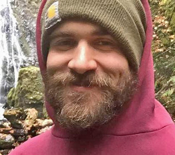
Justin Beebe was a member of the Lolo Hotshots

Justin Beebe
Justin Beebe. USFS photo.

A wildland firefighter with the U.S. Forest Service was killed Saturday August 13 while working on the Strawberry Fire near Baker, Nevada.

The National Park Service and the U.S. Forest Service confirmed that Justin Beebe, a firefighter with the Lolo Hotshots based in Missoula, Montana, succumbed to injuries suffered when he was struck by a tree. The line of duty death of the Bellows Falls, Vermont firefighter will be investigated by the Forest Service.

“This loss of life is tragic and heartbreaking,” said Park Superintendent, Steve Mietz “Please keep the family and Forest Service employees in your thoughts and prayers during this time.”

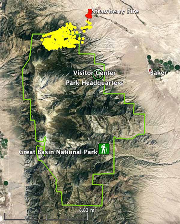
The Strawberry Fire is being managed jointly by Great Basin Incident Management Team 7, the National Park Service, and the Bureau of Land Management. It is burning mostly in Great Basin National Park in eastern Nevada 10 miles west of the Utah/Nevada state line. Since starting from lightning on August 8 it has burned 4,600 acres, but satellites have not detected much heat on the fire since Friday, August 12.

map strawberry fire
The yellow dots represent the location of the Strawberry Fire August 14, 2016.
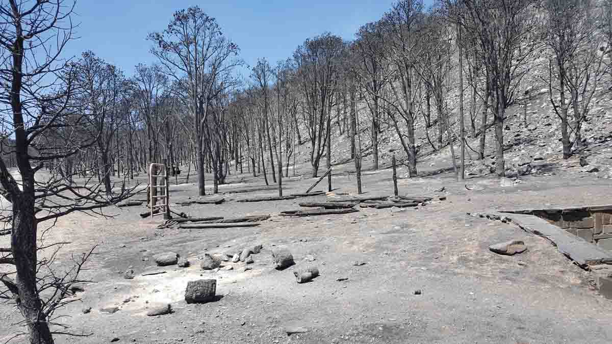
Strawberry Fire trees
Strawberry Fire. Photo by Steve Mietz.

Our sincere condolences go out to Mr. Beebe’s family, friends, and coworkers.

Laboratory camera captures photos of Little Den Fire in Nevada

Above: The Little Den Fire at about 7:55 p.m. MDT July 20, 2016. Screen shot from Nevada Seismological Laboratory camera.

Earlier this month a mountain top camera operated by the Nevada Seismological Laboratory captured excellent images of the Hot Pot Fire near Midas, Nevada as it burned approximately 120,000 acres within its first 30 hours. The still images were converted to time-lapse videos condensing an hour of fire activity into one minute.

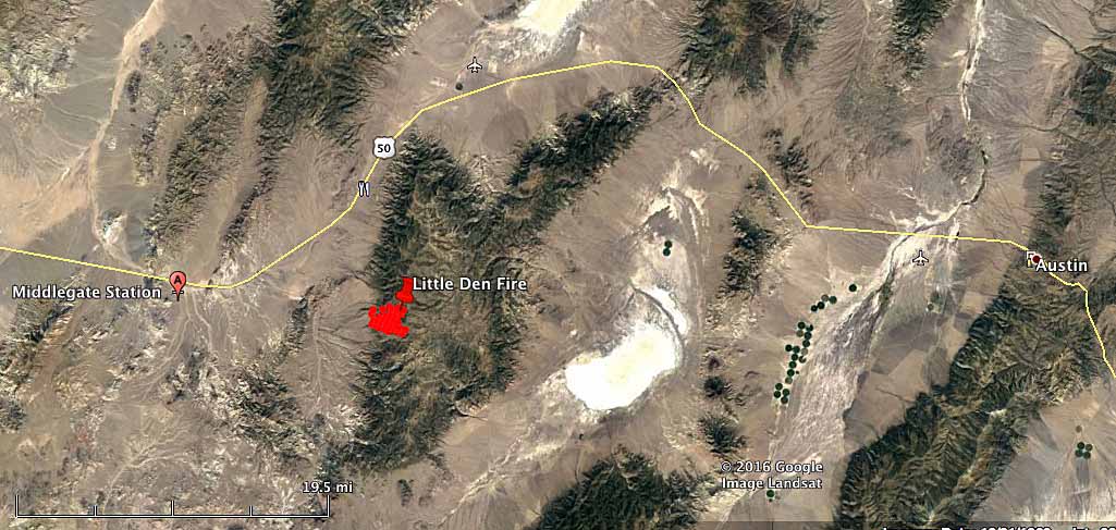
Now it has taken photos of a new fire, the Little Den Fire 39 miles west of Austin, Nevada between U.S. Highway 50 and Highway 2. By Wednesday evening it had burned an estimated 1,800 acres and was being suppressed by 3 hand crews, 7 engines, 3 air tankers, and 2 helicopters. Hecht’s Type 3 incident management team is assigned to the fire.

map Little Den Fire
Map showing heat detected by a satellite over the Little Den Fire at 2:15 a.m. MDT July 21, 2016. Click to enlarge.

In one video you can see the initial stages of the fire as it started at 10:15 a.m. on Wednesday July 20.

The one-minute video below shows the rapid spread of the Little Den Fire from 4 p.m. to 5 p.m. on Wednesday.

The next video covers 7 p.m. to 8 p.m. and has some very interesting images just before sunset showing wind shear effects on the smoke.

Other videos of the Little Den fire posted by the laboratory.

Memorial service for two BLM firefighters to be held July 19

Memorial services have been scheduled for Bureau of Land Management wildland firefighters Jacob O’Malley and Will Hawkins who lost their lives July 10 in a single-vehicle accident July 10 on Nevada State Route 140. The services will take place at the Winnemucca Events Complex Exhibit Hall (map) from 1:00 to 4:00 p.m. on Tuesday, July 19, in Winnemucca, Nevada.

The BLM firefighters were returning from duty in the Denio area on their way back to Winnemucca when the accident occurred at about 5:20 p.m. Sunday evening. Jacob, 27, and Will, 22, were killed in the rollover accident. Their coworker, Zachery McElroy, 23, was flown to Renown Medical Center in Reno, where he was treated; he was released Tuesday afternoon. The BLM fire crew was returning from a routine patrol looking for lightning fires in the area when the accident occurred.

The two men both resided in Winnemucca, though Jacob was from Lake Tahoe’s Zephyr Cove and Will was from Reno. The families of Jacob and Will have established private family memorial services in the Lake Tahoe and Reno areas, respectively.

“Everyone is invited to attend the Winnemucca services on Tuesday to honor Jacob and Will – two brave, hardworking firefighters who were dearly loved by their families and coworkers,” said BLM Nevada State Director John Ruhs.

The BLM deployed a Serious Accident Investigation (SAI) team to determine the accident cause and other
information.

Winnemucca Events Complex (map)
1000 Fairgrounds Road
Winnemucca, NV 89445

Jacob O'Malley
Jacob O’Malley. Photo provided by BLM.
Will Hawkins
Will Hawkins. Photo provided by BLM.

Two firefighters in Nevada killed in traffic accident

Two Bureau of Land Management firefighters have been killed and one was injured in a traffic accident in Nevada at about 5 p.m. on Sunday.

Below is a statement released by the BLM Monday morning:

For those of you who haven’t heard, we are sad to inform you of the loss of two BLM firefighters in an engine accident around 5 p.m. yesterday. A third firefighter sustained serious injuries. They had been patrolling near Denio following a lightning storm and were headed back to Winnemucca when they were involved in a single vehicle accident. Although first responders worked valiantly for a different outcome, two did not survive and the third was airlifted to a hospital in Reno. Our hearts and prayers go out to the engine crewmembers’ families, as well as our brother and sister firefighters in the BLM Nevada fire organization. We will post more information at the appropriate time.

map LODD

Our sincere condolences go out to the family and co-workers of the firefighters.

More wildland firefighters have died in vehicle accidents in the last 25 years than in entrapments.

Hot Pot Fire burns 100,000+ acres in Nevada

Above: Hot Pot Fire burns near Midas, Nevada, July 3, 2016. Screen grab from video by Nevada Seismological Laboratory.

Map Hot Pot Fire
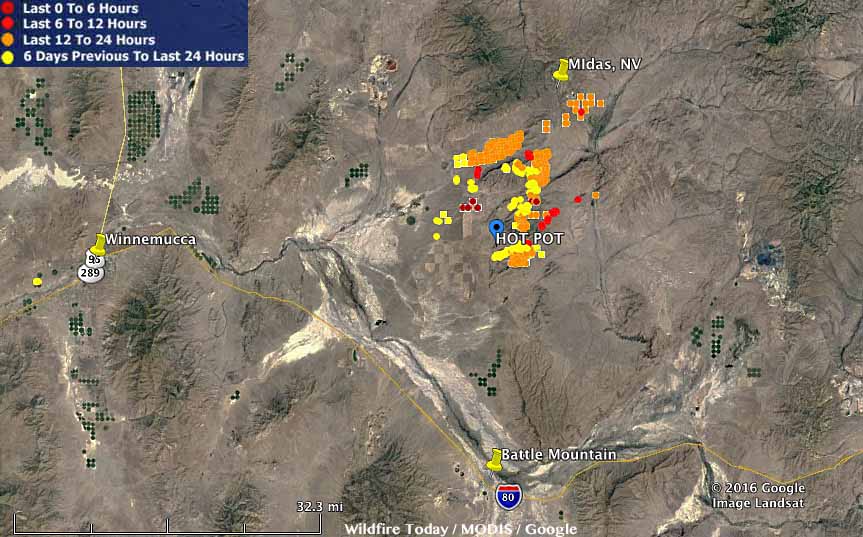
Map of heat sources detected on the Hot Pot Fire by a satellite between July 2 and 4, 2016. Some of the light fuels burned and cooled before the satellite overflight and were not detected. Click to enlarge.
The Hot Pot Fire burned approximately 120,000 acres within 30 hours of starting Saturday afternoon during a thunderstorm about 25 miles north of Battle Mountain, Nevada. 

The image at the top of the article is a screen grab from a web cam operated by the Nevada Seismological Laboratory which has put together more than half a dozen time lapse videos of the fire. Below are a couple of examples; you can view the rest on YouTube. The videos are one minute long, and most of them cover about an hour of real time.

The first video begins about an hour after the fire started on July 2.

In the video below you can see retardant drops at 0:38 and 0:44 if you look VERY carefully. Full screen mode helps. The town of Midas, Nevada is in the tree-lined drainage at the lower-center of the picture.