Weather slows fire activity in Western United States

Above: Accumulated precipitation over the last seven days, June 12-18, 2018. 

Moderating weather over the last seven days has helped firefighters make progress on some of the fires in Colorado, Wyoming, New Mexico, and Utah. Today’s national Situation Report showed little or no increase in the size of wildfires in those four states. The 416 Fire in southwest Colorado and the Badger Creek Fire in southern Wyoming released a total of 345 personnel over the last 24 hours.

Todd Pechota’s Type 1 Incident Management Team is currently assigned to the 416 Fire, but Joe Reinarz’s NIMO team has been mobilized for the fire, which could be an indication that they expect it to be a long term incident. The west side of the fire has spread into steep, remote terrain above 8,000 feet as it grows closer to an 11,000 to 12,000-foot ridge five miles away. Much of the ridge is above the timber line and may eventually, with patience over time, serve as a barrier. Mr. Reinarz’s team team will transition on Friday.

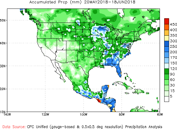
Below, National Weather Service graphics show the observed precipitation and the departure from normal for the last 30 and 90 days.
precipitation 30 days
Accumulated precipitation, May 20 through June 18, 2018. NWS.
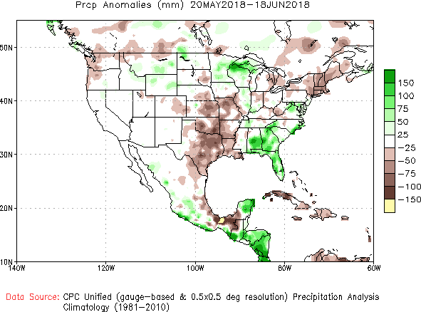
precipitation 30 days
Precipitation departure from average, May 20 through June 18, 2018. NWS.
precipitation 90 days
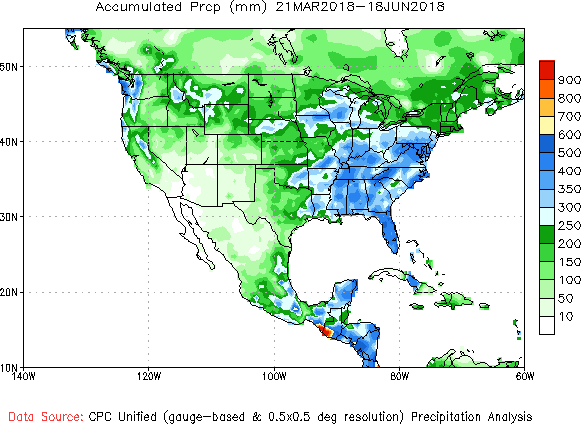
Accumulated precipitation March 21 through June 18, 2018. NWS.
precipitation 90 days
Precipitation departure from average, March 21 through June 18, 2018. NWS.

Ute Park Fire active overnight near the community of Ute Park

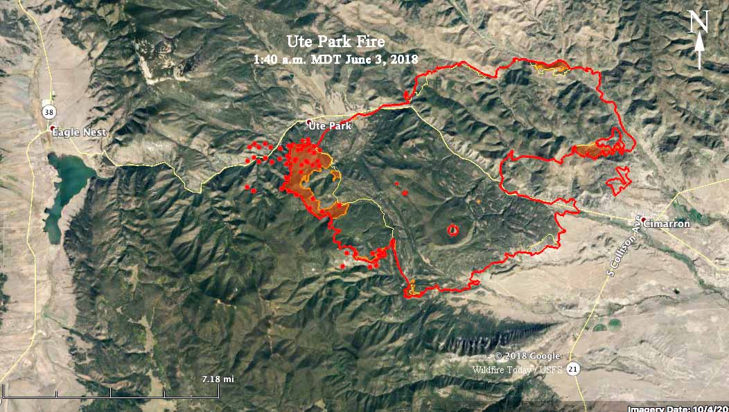
Above: 3-D map of the Ute Park Fire, looking west. The red line on the map shows the perimeter at 10:30 p.m. June 2, 2018.

Increased fire activity near the community of Ute Park prompted the Colfax Emergency Manager and Colfax Sheriff’s Office to issue a mandatory evacuation for the community Saturday afternoon. Winds from the southeast caused the fire to grow to the northwest south of the town. Overnight it kept spreading to the west and a satellite overflight at 1:40 a.m. detected heat on the north side of Highway 64 west of the community. Firefighters are conducting point protection around structures and planned a burnout operation Saturday night to help protect the community which is now encircled by a dozer line.

Saturday’s burning operations to help protect the Cimarron area were successful on the fire’s eastern and southern flanks.

The fire has burned 31,910 acres in northeast New Mexico between Eagles Nest and Cimarron 26 air miles northeast of Taos.

map ute park wildfire fire
The red line on the map shows the perimeter of the Ute Park Fire at 10:30 p.m. MDT June 2, 2018. The yellow line was the perimeter the previous night. The red dots on the northwest side indicate heat detected by a satellite at 1:40 a.m. MDT June 3.

Ute Park Fire grows to 27,000 acres

The Ute Park Fire in Northeast New Mexico expanded to over 27,000 acres on Friday according to a mapping flight at 11 p.m. Friday night. It had the potential to become much larger but it may have been slowed when it spread into the scar from the 2002 Ponil Complex  of Fires. In addition, the wind speed recorded at Cimarron on Friday, 9 mph gusting at 22 to 28 out of the southwest, was less than the prediction of sustained 25 mph southwest winds gusting between 31 and 36.

Map of the Ute Park Fire
Map of the Ute Park Fire at 11 p.m. MDT June 1, 2018.

After sundown Friday the wind decreased to 3 mph with a variable direction, which allowed the fire to spread on the southwest side, probably adding one or two thousand acres to the 27,000 mapped at 11 p.m. But firefighters were able to keep the fire out of Cimarron.

Saturday’s weather forecast for Cimarron is for 84 degrees, relative humidity in the mid-teens, and 12 mph winds out of the northeast in the morning switching to the southeast in the afternoon. The variable wind direction could be problematic for firefighters.

Satellite sensor reports fire that is 142 miles long

Obviously, this was an error

The sensors on satellites that detect fires can be extremely useful, showing us the general location and extent of wildfires.

But as proven again today, they are not perfect. As imported into Google Earth, a VIIRS I 375 meter S-NPP sensor on one of the satellites reported at 1:47 p.m. MDT on Friday that there was a fire 142 miles long stretching across half the width of New Mexico. I feel confident in saying this is incorrect.

Video of driving through the Ute Park Fire

Above: screenshot from the video below.

Apparently these people survived driving through the Ute Park Fire in Northeast New Mexico. As a wildland firefighter for decades, I have never driven through that much fire for that length of time. One of the many disastrous things that can happen is that the fire consumes so much oxygen that there is not enough left to support burning the gasoline in the vehicle’s engine — it can quit and the vehicle will stall, probably in the most intense part of the fire.

All of our articles about the Ute Park Fire can be found HERE.

Satellite photo, smoke from New Mexico wildfires

(Updated at 4:56 p.m. MDT June 1, 2018)

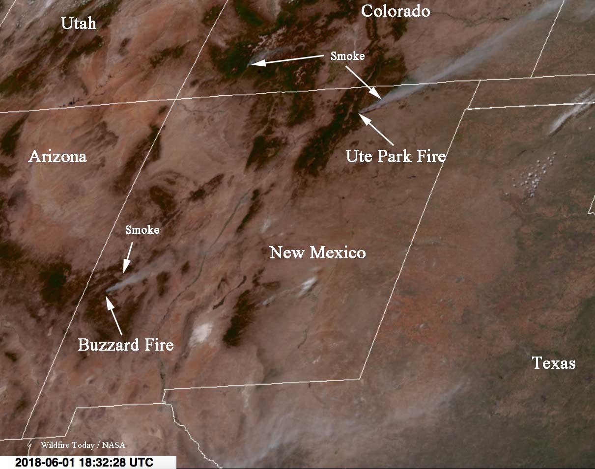
The satellite photo above was taken at 4:32 p.m. MDT June 1 showing smoke from three fires in New Mexico and Colorado.

Below is a photo of the same general area taken four hours earlier. The fires are being pushed by strong winds, resulting in a rapid rate of spread.

Articles on Wildfire Today about the Ute Park Fire.


(Originally published at 1:02 p.m. MDT June 1, 2018)

This satellite photo shows smoke from three fires at 12:32 p.m. MDT June 1, 2018. Two of the fires are in New Mexico, the Ute Park Fire and the Buzzard Fire. Both are being spread rapidly by strong winds which makes the smoke plume long and narrow.

Satellite photo smoke fires New Mexico Colorado
Satellite photo, smoke from fires in New Mexico and Colorado at 12:32 p.m. MDT June 1, 2018.

In southwest Colorado there appears to be a new fire, possibly north of Durango. I don’t believe it is the Horse Park Fire. Update at 1:34 p.m. MDT June 1, 2018. We just confirmed the smoke in Southwest Colorado is from a new fire about 12 miles north of Durango, the 416 Fire.  

Thanks and a tip of the hat go out to Steve.
Typos or errors, report them HERE.