NASA satellite photos of the huge Anderson Creek Fire in OK and KS

Here is the description from NASA of the images below of the Anderson Creek Fire that burned almost 400,000 acres in Oklahoma and Kansas last month:

“In late March 2016, wildfire raged across rural areas of Kansas and Oklahoma. Local authorities and media outlets are calling it the largest grass fire in Kansas history. The Anderson Creek fire started in northern Oklahoma on March 22 and proceeded to burn more than 620 square miles (1600 square kilometers) of prairie and cattle grazing land. No human deaths have been reported, though 600 cattle were killed by the fires. At least 16 homes and 25 structures were lost, as were countless miles of fencing.

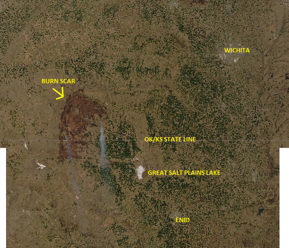
The Moderate Resolution Imaging Spectroradiometer (MODIS) on NASA’s Aqua satellite acquired these two natural-color images of the fire. The first shows the extensive smoke plumes as winds whipped the fires on March 23, 2016. The second image shows the scarred land as it appeared on March 27. Turn on the image comparison tool to see the change.

The wildfire spread quickly due to dry conditions in the region; rainfall has been below normal this spring. By March 31, the fire was close to 90 percent contained, thanks to work by fire crews, the National Guard, and a few inches of snow. Click here to view drone footage of the fire at its peak.”
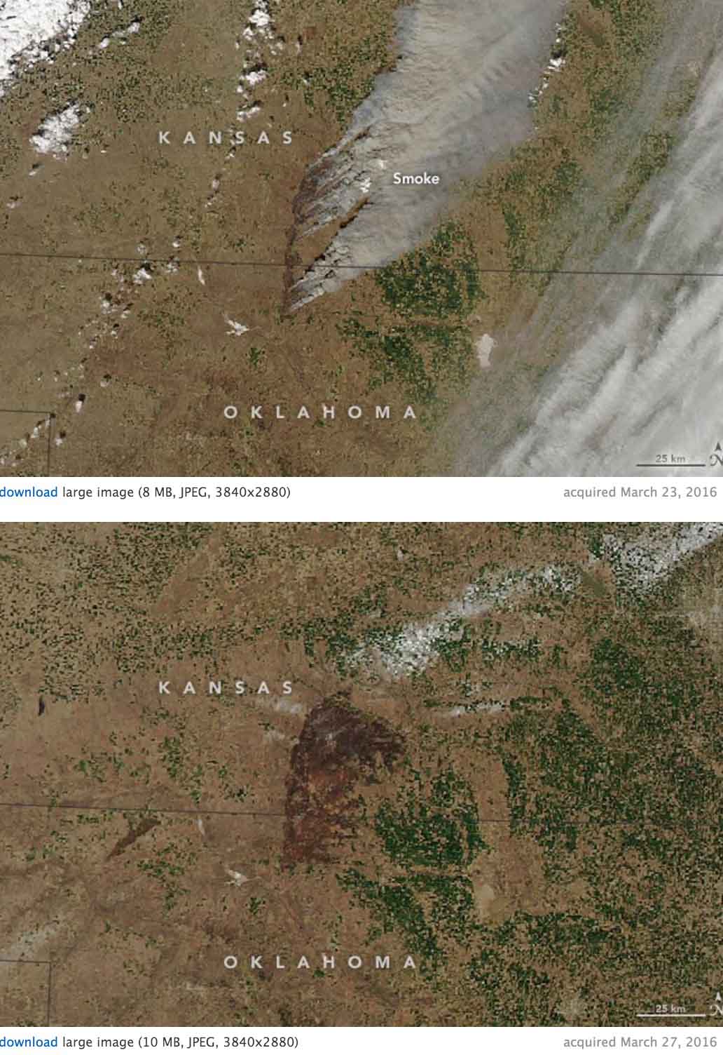
Anderson Creek Fire satellite photo

Anderson Creek fire in Oklahoma and Kansas

(UPDATED at 11:30 a.m. March 25, 2016)

KS-OK fire from space
The Anderson Creek Fire in Oklahoma and Kansas as seen from space. Photo via Damon Lane
@KOCOdamonlane

****

(UPDATED at 12:15 a.m. CDT, March 25, 2016)

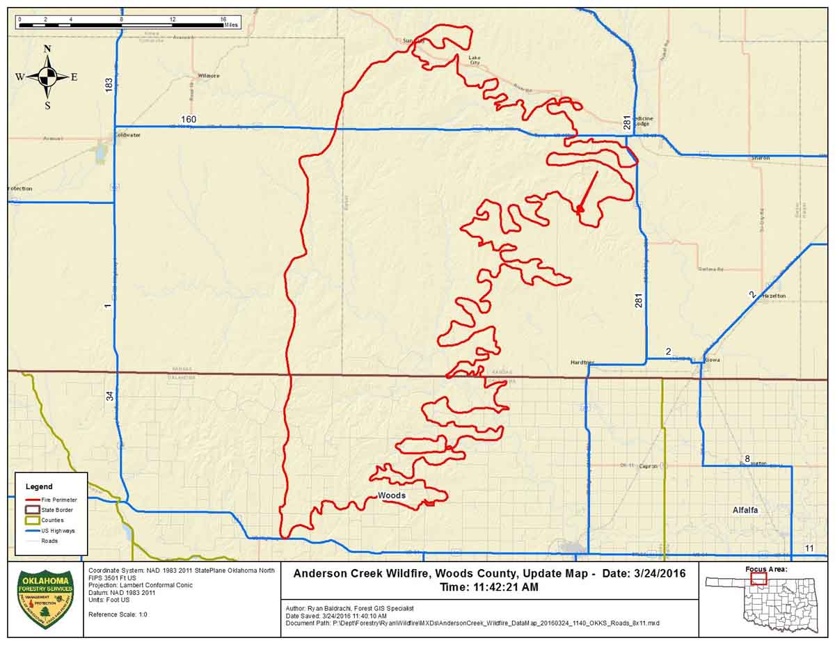
This map was provided by Oklahoma Forestry Services, along with the information that the fire had burned an estimated 397,420 acres and was 0% contained Thursday morning.

Map Anderson Ck Fire 3-24-2016

****

(UPDATED at 6:12 p.m. CDT March 24, 2016)

The video below is a recording of the briefing by public officials of Barber County Kansas the morning of March 24, 2016 about the very large fire insouthern Kansas and northern Oklahoma. It was originally broadcast on Periscope by Amy Bickel, but since recordings there are automatically deleted after 24 hours, we preserved it here. It was recorded off a computer monitor, so we apologize for the low quality.

In the briefing referenced above, the County Attorney said “397,420 acres have burned over the last couple of days”. He did not indicate if that was the size of the very large fire in our maps, or if the acreage includes multiple fires. He also said two homes were destroyed.

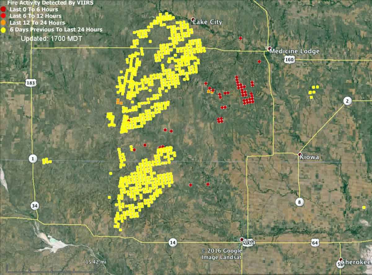
The map below shows heat detected by a satellite at 2:25 p.m. on March 24. The light vegetation in the area may sometimes ignite, burn up completely, and then cool before the next satellite overpass, which can be about 12 hours apart. In this case the mapped data may under-report the true extent of the fire.

map fire wildfire kansas oklahoma medicine lodge
Kansas-Oklahoma fire map at 2:25 p.m. CDT March 24, 2016.

Here is an excerpt from an article at WIBW, dated March 24 at 2:10 p.m.

Strong winds have thwarted efforts to contain a wildfire that has burned 620 square miles of rural land in Oklahoma and Kansas, and it’s now approaching populated areas.

Oklahoma Forestry Services spokesman Mark Goeller said Thursday that strong winds shifted the direction of the fire late Wednesday and overwhelmed existing containment lines.

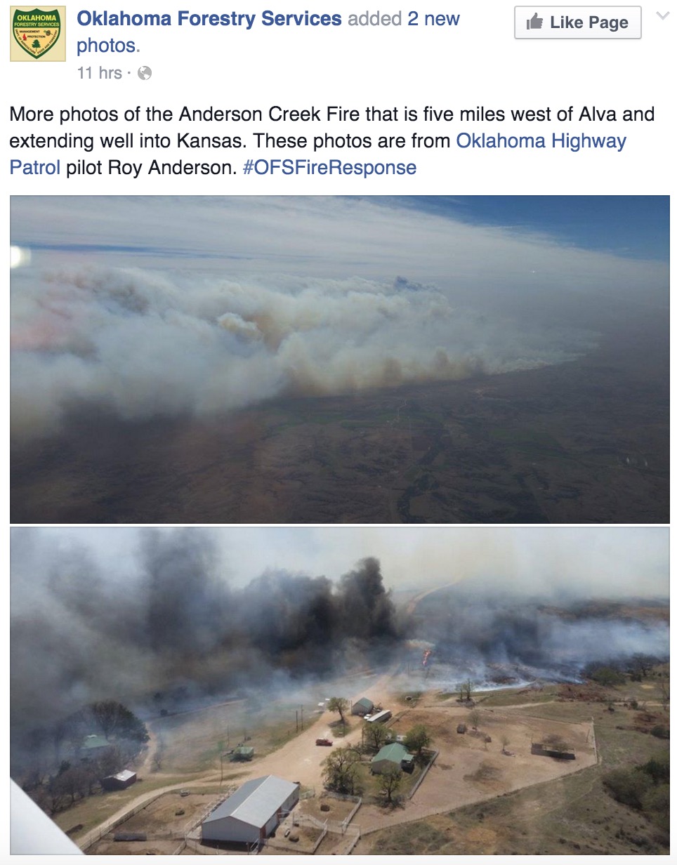
Officials are now monitoring a part of the blaze 5 miles away from Alva, Oklahoma, where about 5,000 people live. No mandatory evacuations have been issued in Oklahoma, though Goeller says officials are forming contingency evacuation plans as crews work to slow the fire’s spread.

Goeller says wind conditions and humidity are expected to improve throughout the day, making progress on containment more likely…

Anderson Creek Fire 3-24-2016

Continue reading

Horses escape from wildfire in Oklahoma

Horses escaping fire
Horses escaping from a fire in Oklahoma. Screen grab vrom the News9 video.

This was the description of the video (below) that News9.com posted on Monday:

Grass fires in Osage and Washington counties are still burning Monday morning. Residents will smell smoke and can see the haze in the air.

Osage SkyNews 6 HD pilot Will Kavanagh flew overhead as wild horses escaped a fire line about five miles north-northwest of Ochelata Monday morning. Strong south winds continue at 20 to near 30 mph.

The fire began burning Sunday and continues in the rural area near the border of the two counties. Video shows the horses crossing a stream with ranchers nearby to help.

Wildfire briefing, March 1, 2016

Wildfire closes I-15 in northwest Arizona

A fire between St. George and Mesquite late Monday caused Interstate 15 to be closed for several hours. A sheriff’s deputy suffered a broken leg when he attempted to assist a resident who was on the roof of a home using a water hose to keep the fire at bay. Mohave County Sheriff’s Office spokeswoman Trish Carter said a person burning weeds on his property caused the fire and may face charges.

Pipeline companies ordered to pay $6.5 M in damages from Oklahoma wildfire

From the Insurance Journal:

Two pipelines companies have been ordered to pay more than $6.5 million in damages to more than 70 plaintiffs whose property was destroyed in a 2012 wildfire in Oklahoma.

Court documents say a Payne County jury ordered IPS Engineering L.L.C. and Global Pipeline Construction LLC to pay the damages to be divided among 72 plaintiffs nearly four years after the fire consumed farmland, homes, timber and other property. Tulsa World reports that IPS Engineering was ordered to pay an additional $1 million in punitive damages, and Global Pipeline Construction was ordered to pay $100,000.

The plaintiffs’ lawyer says the nearly 8-mile fire broke out near Glencoe on Aug. 4, 2012, when company employees continued welding despite a statewide burn ban issued the day prior.

Forest Service requests information about suspicious fire

Fire managers on the Kaibab National Forest in Arizona suppressed a suspicious human-caused fire on Sunday, Feb. 28, just west of Buckskinner Park. The Clover fire, which was reported just after
1 p.m., was knocked down by fire personnel and will continue to be monitored. The fire is currently under investigation by Forest Service Law Enforcement. Anyone with information regarding the cause of the fire, or that observed anyone suspicious in the area near the time of the fire is encouraged to contact Kaibab National Forest Dispatch at 928-635-2601 or Fire Information at 928-635-5653.

Oklahoma firefighter run over by brush truck

The Oklahoma State Firefighters Association announced that on February 26 a Ponca City firefighter suffered traumatic leg injuries after accidentally getting run over by a brush truck.

Lt. Lyle Crandall with the Ponca City Fire Department was seriously injured Friday afternoon [February 26] while responding to a reported grass fire. Lt. Crandall and one other firefighter were on a special detail when the call came in. They had to respond back to the fire station to pick up a brush pumper. During this transfer, Lt. Crandall was accidentally run over by the front tires of the fire engine. Lt. Crandall received immediate treatment from the other Ponca City firefighters and was taken by ambulance to the hospital where they were met by a medical helicopter. Lt. Crandall was flown immediately to OU Medical Center in OKC. He sustained traumatic injury to his left foot and leg as well as his right leg.

Please keep Lt. Crandall, his family, and the Ponca City Fire Department in your thoughts and prayers.

Sincerely,

Dereck Cassady
Ponca City FD
OSFA 3rd VP

Raanon Adams, President

Firefighters battled wildfires in Oklahoma on Thursday

Firefighters battled numerous wildfires in Oklahoma on Thursday. Large blazes near Nuyaka and Cleveland forced residents from their homes.

wildfire smoke map Oklahoma
Satellite image of smoke from wildfires in Oklahoma at 5:07 p.m. CST February 18, 2016.
map fires in Oklahoma
The red dots represent heat from wildfires in Oklahoma detected by a satellite at 2:27 p.m. CST, February 18, 2016.

Four-axle former military HEMTT vehicle used as fire truck

HEMTT fire truck front nozzle

Image above: Pickett Volunteer Fire Department’s HEMTT fire truck. KXII photo.

KXII has a story about a wildfire in Pontotoc County, Oklahoma where the Pickett Volunteer Fire Department used their huge 2,500-gallon wildland fire truck to help extinguish a fire near Ada (map). The vehicle is based on the military’s Heavy Expanded Mobility Tactical Truck (HEMTT), an eight-wheel drive beast manufactured by Oshkosh Truck Corporation. Many variations of the HEMTT were made and are still being used by military organizations around the world to carry cargo, Patriot Missiles, rockets, and portable bridges. There are also several varieties of fire trucks based on the HEMTT that hold from 1,000 to 2,500 gallons. 

Wikipedia had this information about one of the firefighting versions:

The M1142 is a Tactical Fire Fighting Truck (TFFT) capable of extinguishing aircraft, petroleum, brush, and structural fires at isolated military installations. The TFFT is based on a HEMTT M977A2 chassis with the heavier duty M1120 LHS HEMTT variant rear suspension. The TFFT contract was awarded to Pierce Manufacturing with Oshkosh Corporation as a subcontractor to Pierce.

HEMTT fire truck
Pickett Volunteer Fire Department’s HEMTT fire truck. KXII photo.

KXII wrote:

It cost the town only $30,000 through a government program that gives counties retired military equipment.

A vehicle like that would normally cost tax payers about $500,000.

Let us know in a comment if you know of other fire departments using a version of the HEMTT as a fire truck.

****

(UPDATE February 14, 2016)

One of our readers told us about a Maine Forest Service fire station in Greenville that has at least one HEMTT.

Maine FS HEMTT
From Maine Firehouse Photos.
Maine FS HEMTT
From Google Maps Street View.

****

(UPDATE February 16, 2016)

Pat sent us these photos of HEMTTs that are in Idaho.

ID Dept Lands HEMTT
Idaho Department of Lands HEMTT fire truck.
Bonneville CoFD HEMTT
Bonneville County Fire District’s HEMTT fire truck.

Red Flag Warnings, February 8, 2016

wildfire Red Flag Warnings, 2-8-2016


The National Weather Service has issued Red Flag Warnings for areas in Texas, Oklahoma, Kansas and California.

In the California counties of Ventura and Los Angeles 20 to 35 mph northeast winds with gusts of 40 to 50 are in the forecast until 6 p.m. tonight. The Texas and Oklahoma areas under Red Flag Warnings from noon until 6 p.m. CST tonight will experience relative humidities in the teens with wind gusts out of the north to northwest at around 30. Firefighters in south-central Kansas should expect 20 to 30 mph northwest winds gusting to 45 mph along with a minimum humidity of 30 percent from noon until 7 p.m. CST tonight.

The map was current as of 8:45 a.m. MDT on Monday. Red Flag Warnings can change throughout the day as the National Weather Service offices around the country update and revise their forecasts and maps. For the most current data visit this NWS site.