Live reporting from a prescribed fire

prescribed fire video live
Micah and Laura as seen in the video shot at a prescribed fire.
Yesterday firefighters at Indiana Dunes National Lakeshore in northwest Indiana broadcast a live report from a prescribed fire. This is at least the second time we’re aware of that they have used this new feature on Facebook. When they did it on March 19, 2016 Facebook was only allowing a relatively small number of users to stream live. Now they are rolling out this ability to everyone.

Periscope and a few other apps have been doing this for a year or more, but Facebook having this ability to send live video to hundreds of millions of users is a game-changer. I expect we will see more live reports from wildfires and prescribed fires around the world this summer.

Anderson Creek fire in Oklahoma and Kansas

(UPDATED at 11:30 a.m. March 25, 2016)

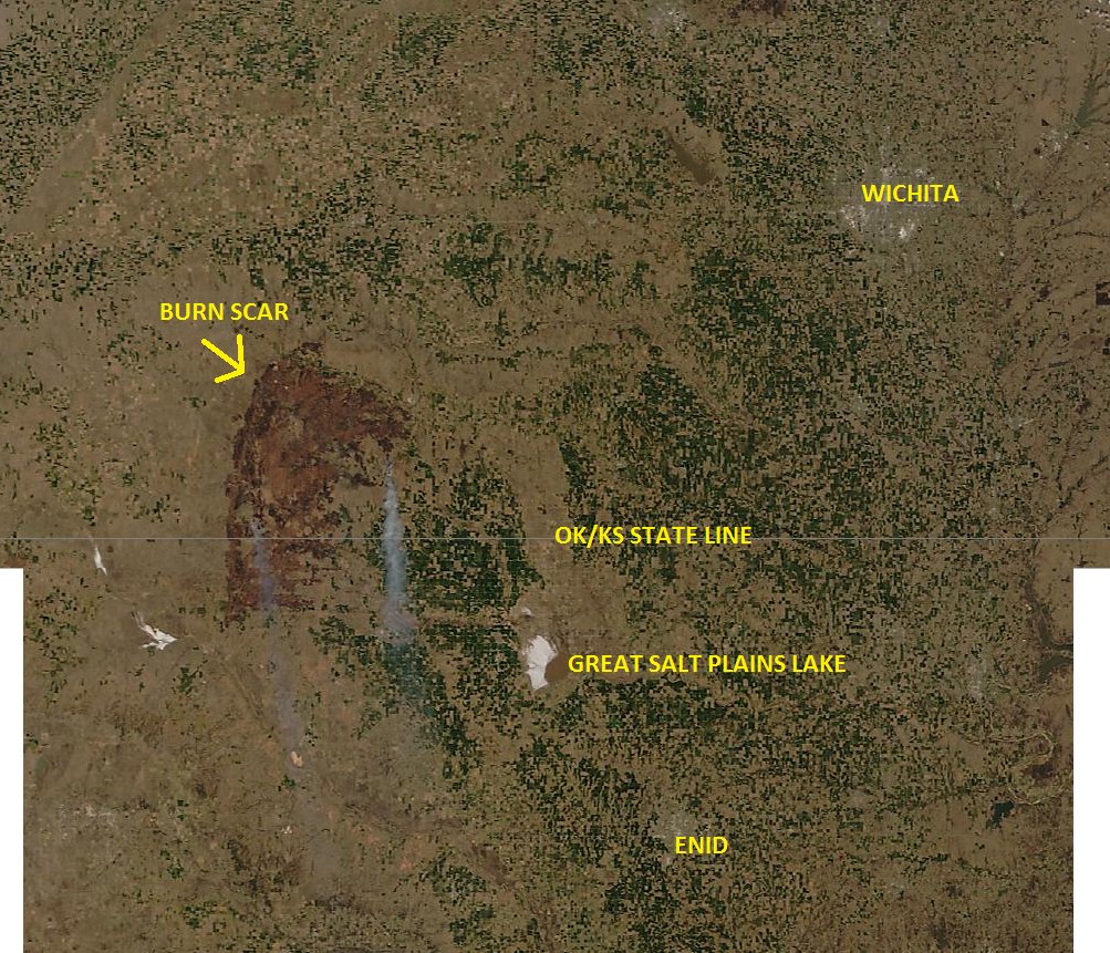
KS-OK fire from space
The Anderson Creek Fire in Oklahoma and Kansas as seen from space. Photo via Damon Lane
@KOCOdamonlane

****

(UPDATED at 12:15 a.m. CDT, March 25, 2016)

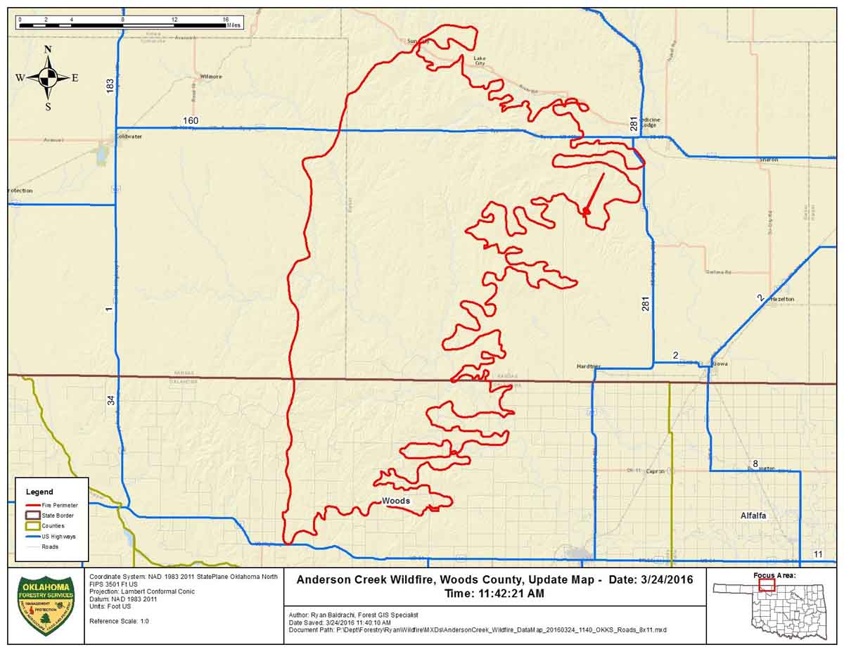
This map was provided by Oklahoma Forestry Services, along with the information that the fire had burned an estimated 397,420 acres and was 0% contained Thursday morning.

Map Anderson Ck Fire 3-24-2016

****

(UPDATED at 6:12 p.m. CDT March 24, 2016)

The video below is a recording of the briefing by public officials of Barber County Kansas the morning of March 24, 2016 about the very large fire insouthern Kansas and northern Oklahoma. It was originally broadcast on Periscope by Amy Bickel, but since recordings there are automatically deleted after 24 hours, we preserved it here. It was recorded off a computer monitor, so we apologize for the low quality.

In the briefing referenced above, the County Attorney said “397,420 acres have burned over the last couple of days”. He did not indicate if that was the size of the very large fire in our maps, or if the acreage includes multiple fires. He also said two homes were destroyed.

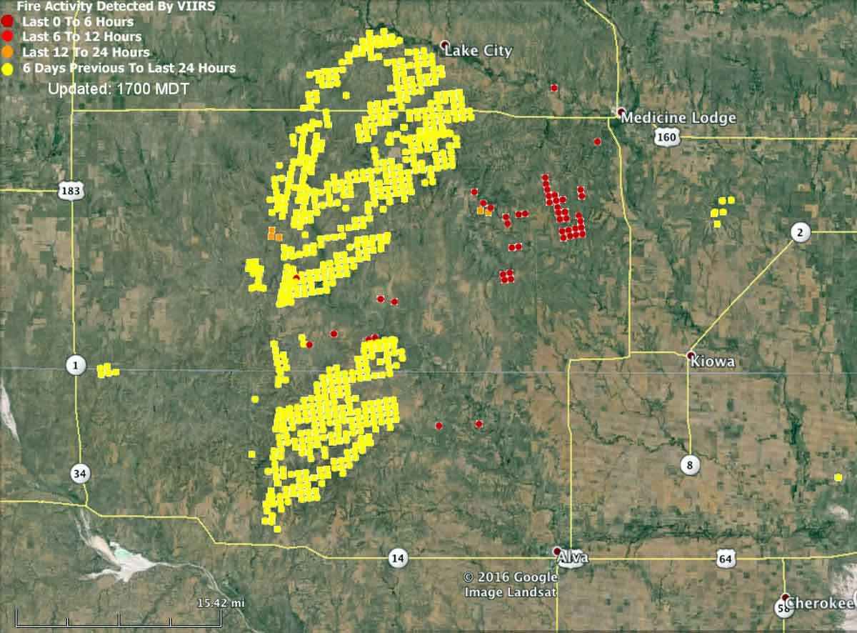
The map below shows heat detected by a satellite at 2:25 p.m. on March 24. The light vegetation in the area may sometimes ignite, burn up completely, and then cool before the next satellite overpass, which can be about 12 hours apart. In this case the mapped data may under-report the true extent of the fire.

map fire wildfire kansas oklahoma medicine lodge
Kansas-Oklahoma fire map at 2:25 p.m. CDT March 24, 2016.

Here is an excerpt from an article at WIBW, dated March 24 at 2:10 p.m.

Strong winds have thwarted efforts to contain a wildfire that has burned 620 square miles of rural land in Oklahoma and Kansas, and it’s now approaching populated areas.

Oklahoma Forestry Services spokesman Mark Goeller said Thursday that strong winds shifted the direction of the fire late Wednesday and overwhelmed existing containment lines.

Officials are now monitoring a part of the blaze 5 miles away from Alva, Oklahoma, where about 5,000 people live. No mandatory evacuations have been issued in Oklahoma, though Goeller says officials are forming contingency evacuation plans as crews work to slow the fire’s spread.

Goeller says wind conditions and humidity are expected to improve throughout the day, making progress on containment more likely…

Anderson Creek Fire 3-24-2016

Continue reading

Indiana Dunes ignites prescribed fires at West Beach

Indiana Dunes National Lakeshore prescribed fire

Indiana Dunes National Lakeshore applied prescribed fire to about half a dozen units yesterday live-streaming from the scene two or three times on Facebook. The recordings are preserved and we posted a couple of them here.

The units the park worked on were in the West Beach area, a portion of the 600 acres they expect to burn this spring. The park is on the south shore of Lake Michigan in northwest Indiana.

Indiana Dunes National Lakeshore prescribed fire

Photos and videos by Indiana Dunes National Lakeshore.

Experiment with live video from a fire via Periscope

Dudley Fire tree felling
Screen grab from Wildfire Today’s Periscope video March 4, 2016.

If you’re not familiar with the smart phone app Periscope, it makes it possible to broadcast to the internet a live video from your phone. The app is free to download and does not cost anything to stream the video. I tried it for the first time today from the Dudley Fire in Buffalo Gap, South Dakota.

The image above is a screen grab from the video as a faller from the U.S. Forest Service was cutting down a large cottonwood tree adjacent to a mobile home. You can view the video HERE, but I believe it goes away after 24 hours, so you’ll need to watch it before 10 a.m. MST on Saturday March 5, 2016.

It is interesting that a couple of seconds before the tree actually started to fall, the dozer, with the blade about 10 feet away, began moving toward the tree and raising the blade — as if he was going to catch it if it started to fall backwards toward the mobile home.

That was the second video I broadcast. I did the first one a few minutes before; it was a little rough, as I held my still camera in one hand and filmed with the phone in the other. Then at the end I had to figure out how to stop it, which took a while.

After you install Periscope on your phone you can follow us by searching for “wildfiretoday”. Optionally, you can be notified when someone you’re following is broadcasting live.

This app has a lot of potential for broadcasting live from a fire scene, a briefing, or a news conference.

More information:
—Our original post on the Dudley Fire.
—Additional photos of the Dudley Fire.

More photos from the Dudley Fire

Dudley Fire Buffalo Gap SD

(UPDATED at 1:20 p.m. MST March 4, 2016 with four more photos.)

Dudley Fire Buffalo Gap SD

Here are more photos from the Dudley Fire yesterday in Buffalo Gap, South Dakota taken by Bill Gabbert.

Dudley Fire Buffalo Gap SD

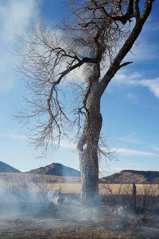
Two large cottonwood trees had fire established in the upper reaches of the branches and were threatening to fall.

Dudley Fire Buffalo Gap SD

xDudley Fire Buffalo Gap SD

Dudley Fire Buffalo Gap SD

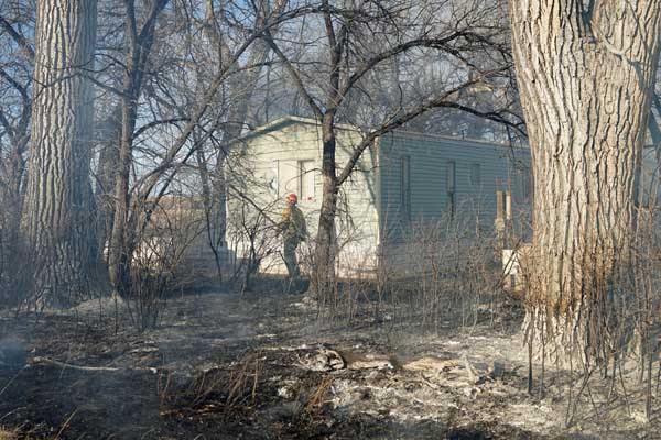
This mobile home was seriously damaged and the asthmatic older woman who lived there may not be able to occupy it again. Rod Converse left this information in a comment on the original thread about the fire:

Please consider joining us in helping Millie Sanford get back on her feet after this fire. Milie is a caring and benevolent lady that has spent her life helping others in need. She did not have insurance, has no place to live and has little resources. If you feel led to help, her address is below.

Thank you.

PO Box 14, Buffalo Gap, SD 57722

Dudley Fire Buffalo Gap SD

The glass windows in the photo above softened and warped but remained in place. The cloudy areas on the panes are bowed out like a wave in the ocean.

Dudley Fire Buffalo Gap SD

You can watch the tall tree nearest the camera being cut down in the live video we broadcast from Periscope. It will go away after 24 hours, so you’ll need to watch it before 10 a.m. MST on Saturday March 5, 2016. More about our experiment with Periscope here.

More information:
—Our original article about the Dudley Fire.
—Links to and information about the live video we streamed from the Dudley Fire.

Dudley Fire burns close to structures in Buffalo Gap, SD

Steven Esser, Dudley wildfire

Above: Steven Esser applies water on the Dudley Fire in Buffalo Gap, South Dakota, March 3, 2016. Photo by Bill Gabbert.

A fire that started in Buffalo Gap burned very close to structures Thursday afternoon in the small town 24 miles south of Rapid City, South Dakota. A response by volunteer fire departments, South Dakota state engines, and personnel from the U.S. Forest Service stopped the fire at two acres. A large pile of old hay bales ignited and will require a significant effort by firefighters to completely suppress.

What started the fire is unknown. A cause and origin investigator was requested by the Incident Commander, but since he would not have arrived until after dark he will be on scene first thing Friday morning.

In addition to the photos you see here, we will post more of the fire on Friday and Saturday. All photos are by Bill Gabbert and are protected by copyright.

(UPDATE March 4, 2016: we posted more photos from the fire here.)

Dudley Fire Buffalo Gap Dudley Fire Buffalo Gap Dudley Fire Buffalo Gap Dudley Fire Buffalo Gap Dudley Fire Buffalo Gap Dudley Fire Buffalo Gap

More information:
—More photos of the Dudley Fire.
—Links to and information about the live video we streamed from the Dudley Fire.

The emergence of Periscope and Twitter as a source for breaking news

In the last few years Twitter emerged as a source for obtaining information about breaking news. Then it was followed by Instagram and in the last few months, Periscope. And of course Facebook belongs in the list as well. In case you’re not familiar with Periscope, it is an app, or program, that can be installed on smart phones that makes it possible to very easily broadcast live video and audio from any location that has good, fast cell phone service. Viewers can interact with the photographer by texting questions that appear on the screen, and can indicate they appreciate the broadcast by tapping the screen which displays heart icons that float up and then off the screen. Some videographers answer the questions verbally.

Periscope has only been around since early this year. It was first available on Android devices in March after the app was acquired by Twitter for $100 million. We have seen some wildfire organizations use it, including CAL FIRE (“CAL FIRE PIO Berlant”) for daily situation reports, and the Sacramento Fire Department (“Sacfire Pio”) which routinely transmits live from incident scenes. But yesterday it came of age — even though it is only a few months old. A fire photographer, EPN564, broadcast live six times from the Valley Fire, about 70 miles north of San Francisco. The high quality video that showed active fire, including homes burning, was striking. There were probably other journalists who also provided video from the fire.

Social media is not a perfect source for news, of course. Citizen “journalists” do not have fact checkers, and occasionally misinformation gets distributed. And there will be those that criticize real-time video of burning homes, but when a news helicopter transmits live video of the same scene, you rarely hear anyone saying that it should be censored.

Below is an excerpt from an article published today at Holistic Marketing Concepts. The author appears to be Tiffany Ann Brown, writing about the revolution in how we are obtaining breaking news, and specifically, news from the devastating Valley Fire last night:

****

“I had quite an interesting night, watching live coverage of a massive fire unfolding in Lake County, California … which also happens to be my husband’s hometown. But rather than seeing anything at all about it on the evening news, I received nearly 100% of my information from Twitter and Periscope. While watching the live coverage on Periscope, I finally experienced firsthand what so many in both business and marketing circles have been talking about for so long: digital (or social) darwinism in action.

It was indeed a defining moment for me, catching live video streams on Periscope, with some of those streams coming directly from various firefighters’ iPhones. Meanwhile, I found it delightful that the general public (and various people tuning in from around the globe) were encouraging them along every step of the way with words of support and concern as these periscopers did their best to share what was happening with viewers live and in real time. In one case, we watched a stream as the number of viewers started at below 100, and within a few minutes grew to over 1,500 viewers.

Not only was this in-the-moment, informative news that I wasn’t getting from any mainstream media sites, but rather than instilling a sense of fear and drama (as is often the case with front-line news reporting), the overall feeling evoked a sense of realism, as well as support, encouragement, and care from the community based on the sentiment of the comments that were filtering through the live chat. ..”

****

Thanks and a tip of the hat go out to Barbara.

Reynolds Creek Fire on Going to the Sun Road in Glacier NP

(UPDATE at 8:30 a.m. MT, July 28, 2015)

Reynolds Creek Fire
Undated NPS photo of the Reynolds Creek Fire, Glacier National Park.

The Reynolds Creek Fire in Glacier National Park in northwest Montana has been relatively quiet recently due to occasional rain. Heavy thundershowers on Monday kept helicopters on the ground for part of the day, but transported cargo when conditions permitted.

Firefighters are removing hazardous trees along Going-to-the-Sun Road which remains closed. Other areas closed include Logan Pass, the Rising Sun Motor Inn, and the Rising Sun Campground.

****

(UPDATE at 11:45 a.m. MT, July 26, 2015)

Skycrane helicopter Reynolds Fire
A Skycrane helicopter drops on the Reynolds Fire. Undated photo from InciWeb.

For the last two days, firefighters, aided by the weather, have been able to minimize any additional growth of the Reynolds Creek Fire burning in Glacier National Park in northwest Montana.

On Saturday crews took advantage of cooler temperatures to build new fireline and reinforce other lines along the St. Mary River, and extinguished spot fires near the southwest edge of the fire. Firefighters began laying hose along firelines to assist with mopup from Rising Sun to the northeast end of the fire.

Fireline explosives will be used Sunday to build fireline in an avalanche chute containing heavy brush and downed logs. The sound of the blast will be audible in the town of St. Mary, and is expected in the early afternoon.

The explosive firefighters use is about 1¼ inches in diameter and 50 feet long; it looks like a long strand of sausage links. The rope-like material is filled with a gel-like PETN material that explodes at 22,000 feet per second after being ignited with one detonation cap. Since the material comes in 50-foot sections, it can be laid out as far as a crew wants to build fire line. It is stored on spools which allow it to be unrolled as firefighters walk over the desired location for the fireline.

The Incident Management Team, led by Incident Commander Greg Poncin, reports that the fire has burned 3,158 acres.

In addition to blowing things up, Sunday personnel on the fire will also continue direct attack supported by aircraft, and expect to be dropping snags and clearing debris near the Going-to-the-Sun Road.

****

(UPDATE at 9:21 a.m. MT, July 25, 2015)

The Reynolds Creek Fire not long after it started on July 21, 2015. Photo by park volunteer Pam Smith.

The Reynolds Creek Fire in Glacier National Park has not spread a great deal over the last two days. More accurate mapping shows that it has burned about 3,100 acres. Examples of some of these more accurate maps are below. Click on them to see larger versions.

Reynolds Creek Fire map 3-d
3-D map of the Reynolds Creek Fire, 10 p.m. July 24, 2015.

Continue reading