
Malheur National Forest
Continue readingCedar Creek Fire in Western Oregon triples in size
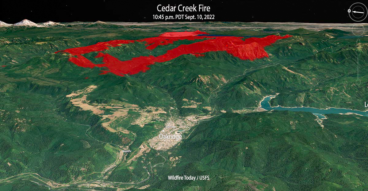 Cedar Creek Fire 3-D map looking east at 10:45 p.m. Sept 10, 2022.
The Cedar Creek Fire that started August 1 in west-central Oregon was already very large at 27,512 acres on the morning of Thursday September 8. But as a result of dry, windy weather on the following two days when a mapping aircraft was over the fire at 10 p.m. Saturday it had more than tripled in size to 85,900 acres. That night the blaze was about 5 miles northeast of Oakridge.
Most of the growth was to the west, driven by strong easterly winds and dry fuels. Saturday evening while winds were from the west, firefighters on the western flank completed strategic burning operations near Eagle Butte, 5 miles northeast of Oakridge. The fire remained north of Highway 58, south of Forest Road 19, and east of Eagle Butte.
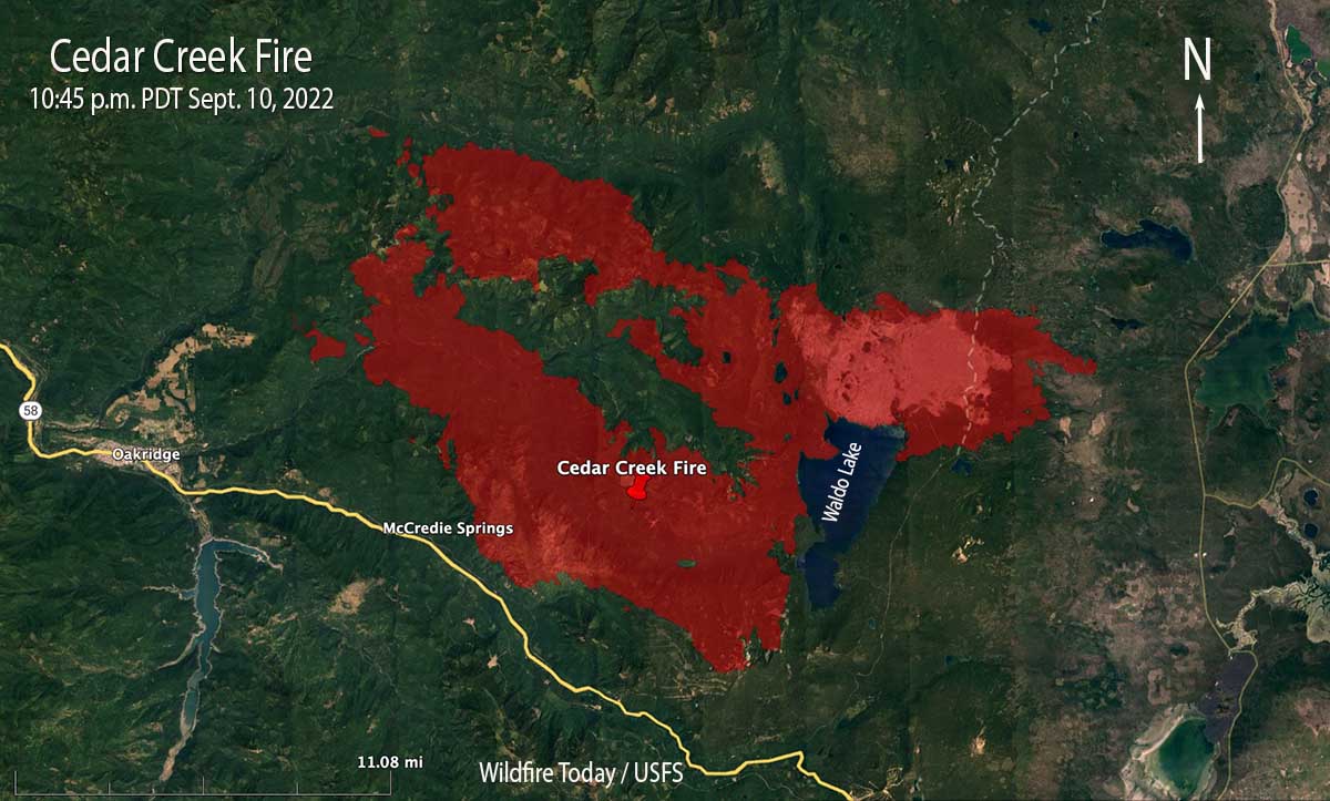 Cedar Creek Fire map, 10:45 p.m. Sept 10, 2022.
The incident management team says 2,230 homes and 443 commercial structures remain threatened, but none have been reported as destroyed. The Office of the Oregon State Fire Marshal has committed seven task forces and an incident management team to the incident.
Saturday evening resources committed to the fire included 17 hand crews, 53 engines, and 8 helicopters for a total of 994 personnel. The estimated suppression costs so far are $47 million.
In the satellite photo below the Cedar Fire is producing the smoke seen in the lower portion of the image.
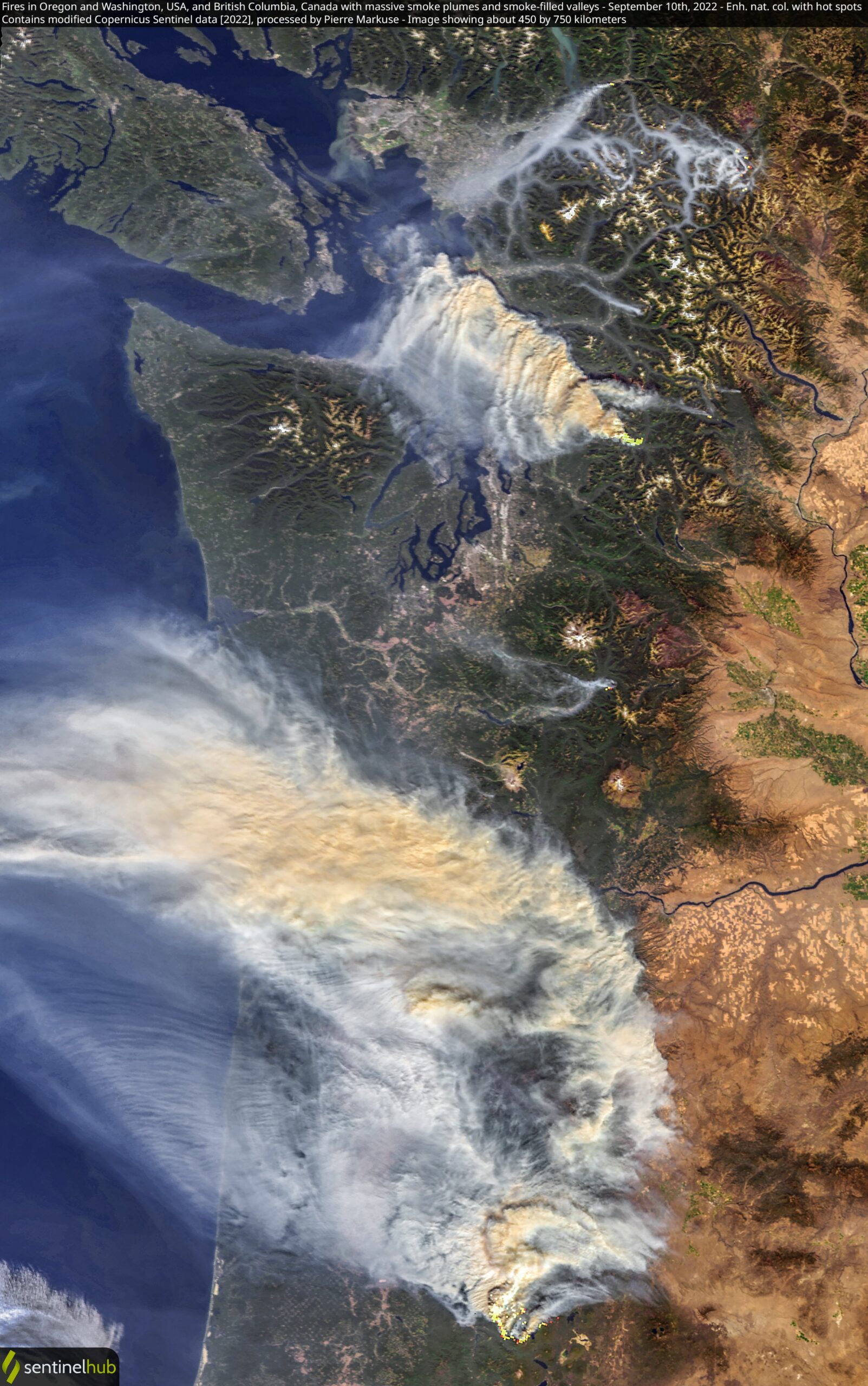 Satellite photo, Bolt Creek and Cedar Creek fires Sept. 10, 2022. Processed by Pierre Markuse.
New fire pushes smoke into northwest Washington
The Bolt Creek Fire near Skykomish is growing rapidly
Continue readingA quick look at seven fires in the Central Idaho area
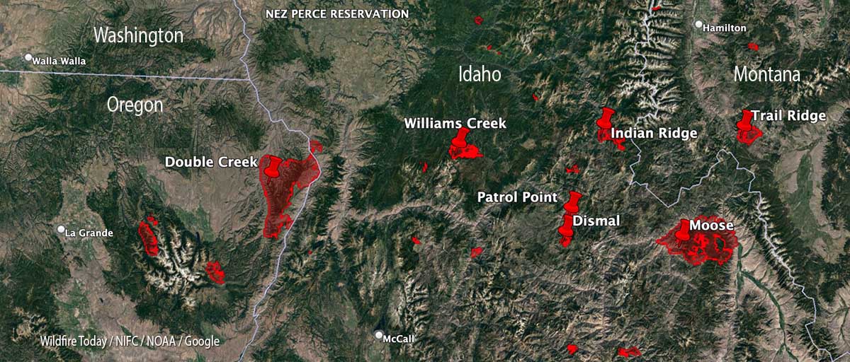 Map of fires in central Idaho, Sept. 9, 2022.
With 35 large uncontained wildfires currently burning in the United States, and many, many more in various categories, we can’t report extensively on all of them, so today we will take a slice of geography and look briefly at seven fires spreading in the Central Idaho area, and extend it just a bit into Oregon and Montana.
Moose (Idaho)
The largest of these seven fires is the Moose, which has been chewing through eastern Idaho since July 17. As far as the cause, the Salmon National Forest says, after almost two months, it is “human caused,” which only eliminates the causes of volcano and lightning. Nine structures have been destroyed. On Friday 650 personnel are assigned to the 125,000-acre blaze which is 5 miles northwest of Salmon, ID. A satellite overflight Friday afternoon only found large heat sources in the southeast portion and that is where an additional 15,000 acres burned Wednesday night, prompting evacuations near Salmon.
Crews reengaged the fire and began preparing new contingency lines along the west edge of the city. Several water pumps, five log decks, and some portable water storage tanks (nicknamed pumpkins because of their shape and color) were destroyed Wednesday. No firefighters were injured. Nearly 500 acres of the city’s Municipal Watershed burned that night, something the various incident management teams had been trying to protect since July.
Cooler temperatures, higher relative humidity, and thick smoke contributed to minimal fire behavior across the fire Thursday.
Indian Ridge (Idaho)
Northwest of the Moose Fire near the Montana border is the lightning-caused 8,670-acre Indian Ridge Fire on the Bitterroot National Forest. It is in the Selway-Bitterroot Wilderness 30 miles southwest of Darby, Montana. The fire has been active this week primarily along the western and northern flanks and north of Indian Creek as it burns through steep, rugged, remote terrain with heavy surface fuels and dead standing timber.
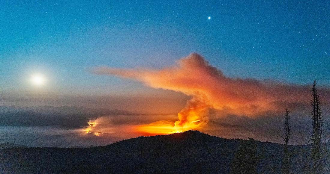 Indian Ridge Fire the night of August 18, 2022. InciWeb.
The fire is not being fully suppressed. Their daily reporting says, “Fire managers are utilizing a point protection strategy to prevent any critical wilderness infrastructure from being negatively impacted by the fire.”
Dismal and Patrol Point
These two fires are very close to merging after significant growth since September 6, and combined have burned an estimated 23,000 acres. They are about 50 miles northwest of Salmon, Idaho. Smoke and the unavailability of infrared mapping aircraft have made it difficult to determine the current perimeters, but there is a lot of new burned acreage between the two fires. Recent low humidity and strong winds are in part responsible for the recent growth.
Areas that fire managers intend to protect include Cold Meadows Guard Station, Root Ranch, and Lantz Bar.
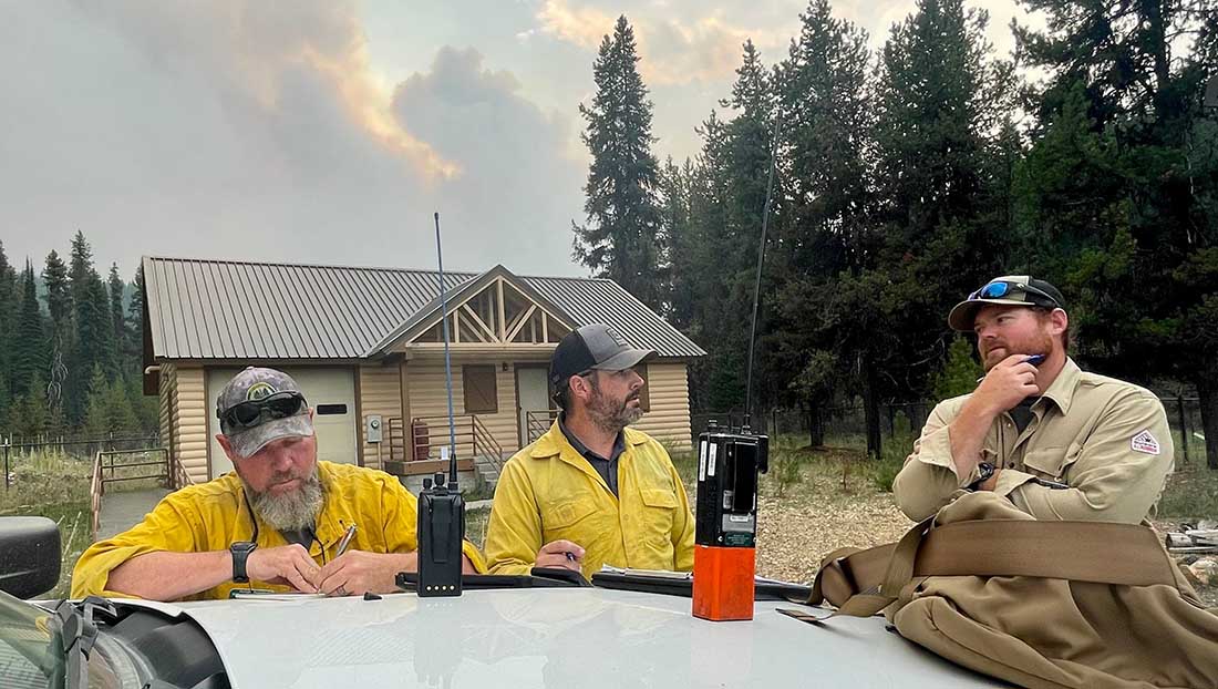 Fire personnel on the Williams Creek Fire in Idaho. InciWeb, posted 9-8-2022.
Williams Creek
The 11,881-acre fire is 5 miles west of Orogrande, near Wildhorse Lake, 7 miles southwest of Elk City, and 8 miles north-northwest of Dixie.
“Resources will continue to engage the fire in Orogrande and the Crooked River corridor, addressing and extinguishing hot spots and conducting damage assessments,” said a September 9 update from the Incident Management Team. “The fire and associated winds did impact structures and outbuildings; crews are still assessing the extent of the damage. Fallen trees, burned snags, and downed power lines continue to present safety hazards.”
Double Creek (Oregon)
The 137,000-acre lightning-caused Double Creek Fire is in Oregon just west of the Idaho border. It has burned to the Snake River in the Pittsburg Landing area. A River Group has been established to assess and protect structures along the waterway. The fire is being fully suppressed and crews are looking for locations to establish the control line farther from Lower Imnaha Road where topography allows. Two structures have been destroyed.
Trail Ridge (Montana)
The 13,000-acre Trail Ridge fire is on the Beaverhead-Deerlodge National Forest in Western Montana about 5 miles east of the Idaho Border and 4 miles southeast of Sula, MT. The cooler weather experienced Thursday and Friday was helpful in slowing the spread of the fire and decreasing the severity of fire behavior. It is burning above 7,000 feet elevation near the Continental Divide and there is no current or expected threat to private land and property. It is not being fully suppressed.
Helicopter makes forced landing during logging operation
Sikorsky S-61N
Continue readingEvacuations in effect for the Rum Creek Fire in southwest Oregon
14 miles northwest of Grants Pass, Oregon
Continue readingArrest made in theft of wildfire detection equipment in Oregon
 Person suspected of stealing solar panel and battery from Oregon DOF fire camera system August 14, 2022. Image from surveillance footage.
An anonymous tip led to the arrest of a thief who broke into an Oregon Department of Forestry (ODF) lookout tower in the Prospect area last week [and stole batteries and solar panels used to power the lookout tower’s fire detection camera]. The suspect, Chad Allen McPherson, 30, of Prospect, was indicted today, August 23, by a Grand Jury and charged with second-degree burglary, first-degree theft, first-degree criminal mischief, possession of burglary tools, and felon in possession of a restricted weapon. McPherson is lodged in the Jackson County Jail and due to a parole violation for felon in possession of a firearm is not eligible for pre-trial release.
McPherson and another suspect were captured on surveillance footage breaking into the tower around 12:45 on Sunday, August 14. The additional suspect shown in the surveillance footage has not been identified. Jackson County Sheriff’s Office (JCSO) detectives have identified a person of interest and are actively working to identify the additional suspect by analyzing latent prints and submitting DNA.
JCSO detectives arrested McPherson during a traffic stop Friday after receiving the tip and matching his photos to the surveillance footage. After searching his vehicle, detectives discovered burglary tools. During a search warrant of his property on the 2000 block of Shelly Lane in Prospect, detectives found a restricted weapon he was prohibited from possessing as a convicted felon. Investigators also discovered a black-market marijuana grow on the property. Illegal Marijuana Enforcement Team (IMET) detectives served a search warrant and destroyed 256 cannabis plants and 300 lbs. of processed black-market marijuana on the property. There was no licensing for any type of cannabis growing, handling, or processing at this location.
Later Friday, Dispatch received a call about a duffel bag at the intersection of 1st Street and Highway 62 with a note which read “call the cops.” JCSO deputies retrieved the bag and it contained items matching that of the stolen ODF equipment. The solar panels and batteries are still missing. The theft disabled ODF’s early fire detection capability for the northeastern portion of Jackson County near Prospect. ODF is currently working to get the camera system back up and running.
This case is ongoing with detectives working additional leads. If you have any information on the additional suspect or the whereabouts of the missing equipment, call the JCSO Tip Line at (541) 774-8333 and reference case 22-4725.
From the Jackson County Sheriff’s Office in Oregon.
After the arrest the Oregon Department of Forestry said, “Some of the equipment has been retrieved, however we’re still moving forward in ordering the parts and pieces we need to get our camera back up and running; early fire detection is one of our top priorities.”
Thanks and a tip of the hat go out to Tom.
Firefighter killed by falling tree in Oregon
On the Rum Creek Fire north of Galice, OR
Continue readingThieves steal fire detection camera equipment in Oregon
Sheriff needs help identifying person in photos
Continue readingFirefighter killed at a wildfire in Oregon
Updated 9:12 a.m. PDT August 12, 2022
The 24-hour Preliminary Report was released today for the August 10 fatality on the Big Swamp Fire in Oregon.
Below is the narrative from the document:
Narrative: A crewmember from a Bureau of Land Management Interagency Hotshot Crew was killed as a result of critical injuries sustained during firefighting operations on the Big Swamp Fire. He was struck by a falling tree and transported via helicopter to a local hospital where he was pronounced deceased.
Notifications to the family have been made and preliminary steps taken to convene an Interagency Serious Accident Review team ordered to facilitate organizational learning.
/s/ Duane Bishop – Acting Forest Supervisor, Willamette National Forest
Updated 12:23 p.m. PDT August 11, 2022
 REACH Air Medical helicopter arrives at the Roseburg Regional Airport with Firefighter Collin Hagan’s body. Douglas County Sheriff’s Office photo.
The Douglas County Sheriff’s office reported that the firefighter who was killed on the Big Swamp Fire in Southwest Oregon on August 10 was 27-year-old Collin Hagan of Toivola, Michigan.
Shortly after 12:30 p.m., 9-1-1 dispatchers received information that a wildland firefighter was critically injured after being struck by a tree. An ambulance and REACH Air Medical Services were dispatched to the scene. Despite lifesaving efforts by EMS personnel assigned to the fire, Mr. Hagan succumbed to his injuries.
Mr. Hagan’s body was flown from the Toketee Airstrip to the Roseburg Regional Airport by REACH Air Medical Services helicopter. Firefighters from the Bureau of Land Management, US Forest Service, Roseburg Fire Department, and Douglas County Fire District #2 stood together to honor Mr. Hagan as his body arrived and was transferred to the care of a funeral service provider. The firefighters then provided an honor escort to the funeral home.
“We are devastated by the tragic loss of a cherished firefighter working on our forest to save our communities and beloved recreational areas,” said Duane Bishop, Acting Forest Supervisor on the Willamette National Forest. “Their family has been notified and we are working with our partners to ensure the crew is well taken care of. Our hearts and prayers go out to the families and fellow crew members of this brave firefighter.”
Updated 8:43 a.m. PDT August 11, 2022
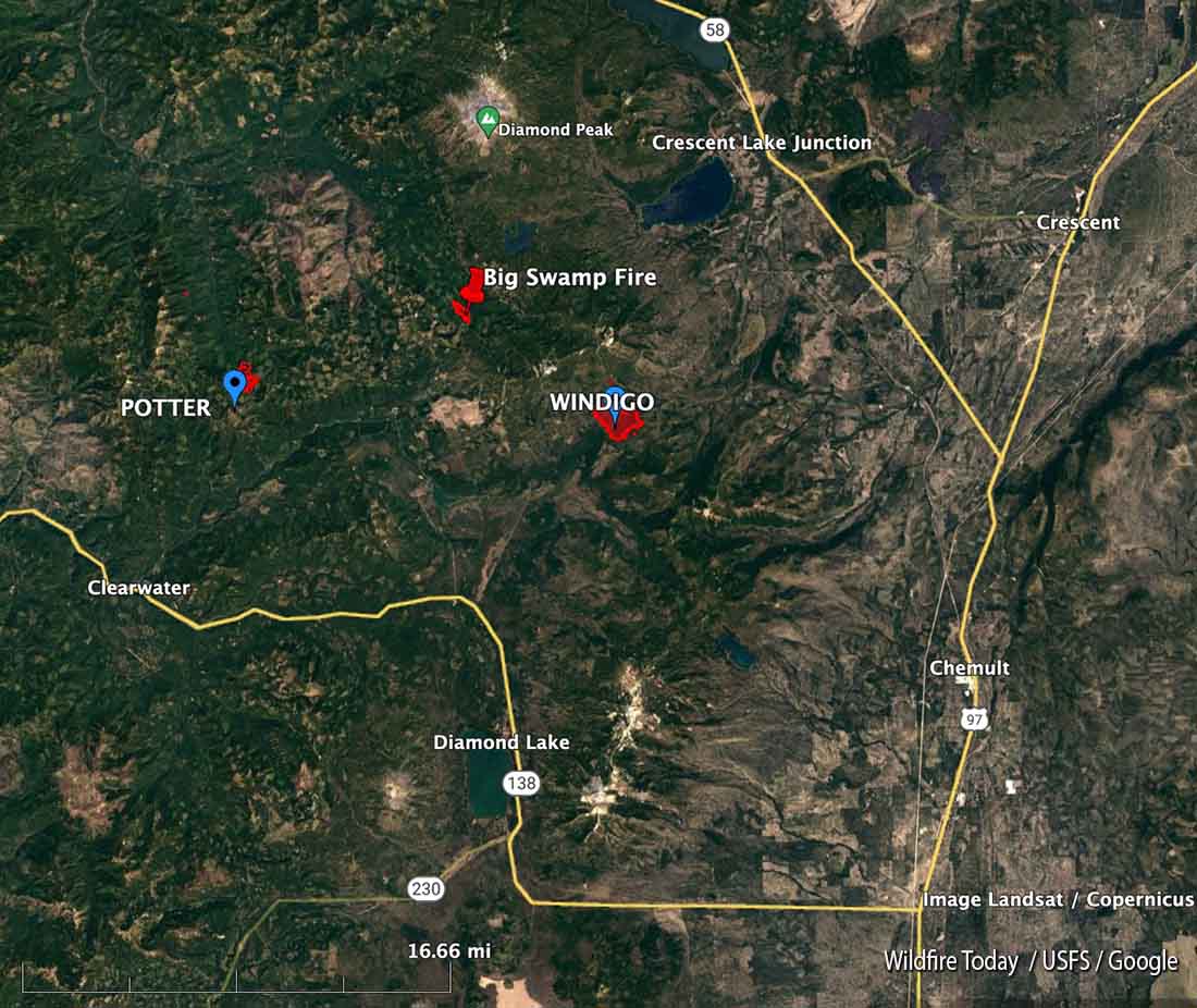 Map, location of Big Swamp Fire, August 11, 2022.
The National Interagency Fire Center reported early Thursday morning that on August 10, a member of the Craig Interagency Hotshot Crew was fatally injured while assigned to the Big Swamp Fire on the Willamette National Forest in southwest Oregon.
A Serious Accident Investigation Team has been mobilized. As of 8 a.m. Thursday morning the name of the deceased had not been released.
The Craig Interagency Hotshot Crew, founded by the Bureau of Land Management in 2001, is based in Craig, Colorado.
The Big Swamp Fire has burned 117 acres. It is 5 miles northwest of the 1,009-acre Windigo Fire and 62 miles southeast of Eugene. The August 10 update from the Incident Management Team said crews were securing line, mopping up, and looking for opportunities to put in direct fire line. It is one of four blazes being managed by Northwest Incident Management Team 6. The others are Windigo, Potter, and Shelter Fires.
Our sincere condolences go out to the family, friends, and co-workers.
 The red shaded area represents the Big Swamp Fire in southwest Oregon, mapped at 9:29 p.m. PDT August 10, 2022. Looking northwest.