(Originally published at 12:55 p.m. MDT January 2, 2018)
On January 1 the Predictive Services section at the National Interagency Fire Center issued their Wildland Fire Potential Outlook for January through April. The data represents the cumulative forecasts of the ten Geographic Area Predictive Services Units and the National Predictive Services Unit.
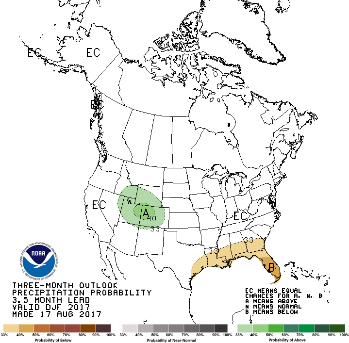
If the prediction is accurate, Southern California should see higher than normal wildfire activity throughout the period, with increasing potential in the southwest and southern great plains. The forecast for the southeast is for normal to below normal activity.
Below are:
The highlights of the NIFC narrative report for the next several months;
NIFC’s monthly graphical outlooks;
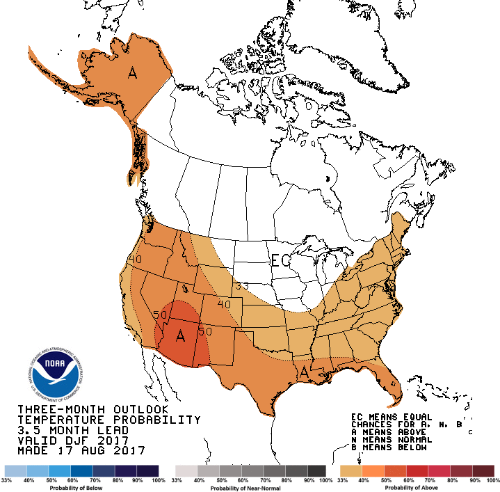
NOAA’s three-month temperature and precipitation forecasts; and
Drought Monitor.
“…Looking forward, a less amplified pattern is expected to develop for January and February with the mean position of the high pressure ridge being along or just off the West Coast. This should result in overall slightly colder than average conditions in northern areas with pockets of above average precipitation over the Northwest and Great Lakes regions. There is some concern that an active, westerly flow could produce overall warmer and drier than average conditions in March and April in these areas. Across the southern tier of the country, the overall warmer and drier than average conditions will continue through February and into March and possibly April. For this outlook period, the areas of note for increased fire potential will remain Southern California and the southwest. The Great Plains could see periodic increases in activity when wind events arise.”
Drought Monitor
Cheers to a new year filled with fire, conservation and helping make this beautiful earth even better, one #rxfire at a time.
Dry offshore winds predicted for Southern California next week.
Above: wildfire potential for December, 2017.
(Originally published at 8:12 a.m. MDT December 2, 2017)
On December 1 the Predictive Services section at the National Interagency Fire Center issued their Wildland Fire Potential Outlook for December 2017 through March 2018. The data represents the cumulative forecasts of the ten Geographic Area Predictive Services Units and the National Predictive Services Unit.
If the prediction is accurate, Southern California and Southern Kansas should see higher than normal wildfire activity, with increasing potential in New Mexico, Texas, and Oklahoma in the latter part of the period.
Below are:
The highlights of the NIFC report;
NIFC’s graphical outlooks;
NOAA’s long range temperature and precipitation forecasts; and
Drought Monitor.
“Warm and dry conditions continued across Southern California and the Southwest in November. The wind events observed across Southern California in October ended in early November. Periodic wind episodes in mid-to-late November led to slight increases in fire activity in New Mexico. In the Southeast, the autumn fire season was held in check by the passage of occasional, precipitation-bearing frontal systems that kept fire danger indices from reaching levels similar to what was observed in November 2016. Across the remainder of the country, regions were generally out of fire season as fire activity remained low.
“Temperatures across the Southwest and California were generally above average in November as high pressure off the coast of Baja California dominated. New England also experienced above average temperatures. Alaska experienced temperatures that were well above average for the first half of the month but saw a pattern shift during the middle portion of the month that allowed for below average temperatures to develop. The remainder of the country experienced near average temperatures through the month. Precipitation deficits mounted across the Southwest and Southern California as the weak La Nina-like conditions persisted. The overall dry, westerly flow across the Great Plains also allowed for pockets of drought conditions to emerge. Wetter-than-average precipitation continued across the northwestern portion of the country and across the Great Lakes region. In Alaska, precipitation was near average.
“Latest data shows that the patterns observed in November persisting through the winter months across the nation. Mountain snowpack should be at least near average except across the Southwest where below average snowpack is expected. The potential for above normal snowpack exists from the northern Sierras north to the Canadian border. An elevated potential for significant snowfall also exists across the Great Lakes region. Temperature departures should be stratified with the northern tier of the country experiencing overall colder-than-average temperatures and the southern tier of the country experiencing warmer-than-average temperatures.”
On November 1 the Predictive Services section at the National Interagency Fire Center issued their Wildland Fire Potential Outlook for November through February. The data represents the cumulative forecasts of the ten Geographic Area Predictive Services Units and the National Predictive Services Unit.
If the prediction is accurate, Southern California should see higher than normal wildfire activity well into next year.
Below are:
The highlights of the NIFC report;
NIFC’s graphical outlooks;
NOAA’s long range temperature and precipitation forecasts; and
Drought Monitor.
“Warm and dry conditions continued across California and the Southwest in October. Several easterly, multi-day wind events coupled with high heat and very low humidity values contributed to significant bursts of fire activity California mid-month. A passing front at the end of the third week of the month brought much needed moisture to the dry fuels across the northern half of the state. The southern half of the Great Basin also saw an increase in grass fire activity during the month due to the warm, dry, and occasionally breezy conditions.
“Looking elsewhere, most of the rest of the nation exited the core fire season though occasional activity was observed along the Rocky Mountain Front in Montana and Wyoming. The autumn fire season in the Southeast was much quieter than the previous year due to the passage of several wet cold fronts that brought timely and occasionally abundant moisture.
“Temperatures across the East, Southwest, and California were generally above average for the month with some locations along both the East and West Coasts reaching as much as fifteen degrees above average at points. The Pacific Northwest, Northern Rockies, northern Great Basin, and central Rockies generally experienced cooler-than-average conditions though a warming trend developed near month’s end. Alaska was generally colder and wetter than average.
“Precipitation departures from average showed significant dryness across the southwestern quarter of the nation and across much of Texas. Significantly wet conditions were observed across the Northwestern quarter of the country as several very wet systems impacted the region during the middle to latter half of the month. Another wet signal for the month was observed across the Great Lakes Region and the Ohio and Tennessee River Valleys.
“Latest forecast data suggests that California will remain the focus of periodic bursts in fire activity through November and possibly into December. Portions of the Deep South may also exhibit increased activity in between precipitation events as well. By February, the focus will shift to the southern Great Plains as the antecedent dry conditions begin to take its toll.”
On October 1 the Predictive Services section at the National Interagency Fire Center issued their Wildland Fire Potential Outlook for October through January. The data represents the cumulative forecasts of the ten Geographic Area Predictive Services Units and the National Predictive Services Unit.
If the prediction is accurate, October should see higher than normal wildfire activity in the northern Rockies and along the California coast.
Below are:
The highlights of the NIFC report;
NIFC’s graphical outlooks for September through November;
NOAA’s long range temperature and precipitation forecasts; and
Drought Monitor
“Abundant rain and mountain snowfall across the Pacific Northwest, Northern Rockies, and Great Basin in mid-September ended the record dry conditions and brought fire danger indices down to seasonal levels entering October. While drought conditions continue across these areas, short-term fire impacts have been minimized. The Southeast continued to receive sufficient moisture, keeping the region at low potential for wildfire. Temperatures were above average for the month across the West. However, there was a significant cooling occurred with the mid-month rain and snow. By month’s end, temperatures had returned to average levels. In the East, temperatures were generally below average.
“Three historically significant weather events occurred during the month. Hurricane Harvey made landfall on the Texas Coast, dropping 45 to 50 inches of rain and producing catastrophic flooding in southeast Texas, including the Houston area. Hurricane Irma battered the U.S. Virgin Islands and Puerto Rico before making landfall in Florida as a major hurricane. Hurricane Maria crossed Puerto Rico with strong winds and considerable flooding, causing catastrophic damage to the island.
“Weather patterns along the West Coast allowed fuels to dry and become receptive to fire should events arise. October marks the beginning of the fall fire season in California as the state becomes susceptible to offshore winds. Events are typically multi-day in duration and vary in intensity. Indicators suggest that this could be an active season for the development of these events during October and November before the state exits its season in December. The fall is also typically a peak in fire activity for the Southeast. While normal significant fire potential is expected for most areas during this outlook period, the Southeast will need to be monitored for above normal conditions and activity in November.”
At the beginning of the month here on Wildfire Today we usually summarize the National Interagency Fire Center’s (NIFC) monthly prediction of wildfire potential for the next three to four months. Their analysis represents the cumulative forecasts of the ten Geographic Area Predictive Services Units and the National Predictive Services Unit.
The primary variable factors that affect large scale wildfire activity are the condition of the fuel (vegetation) and the weather when the fires ignite and continue to burn. In the western United States the amount of the lighter fuels available, such as grass, is affected by the precipitation in the winter and spring. That same precipitation also affects the amount of moisture in the live fuels as well as the dead and down duff and woody material.
Another factor that we have often said is even more important than conditions in the winter and spring is the weather DURING the fire season. In the West if the summer is relatively cool and wet, the fire activity will be less intense than average. On the other hand, a hot, dry summer can lead to more acres burned than normal — in spite of the winter/spring weather.
When someone asks me during the first six months of the year for my prediction of the coming Western fire season, I will tell them to ask me again in August.
This year many areas in the West had unusually high amounts of rain and snow over the winter which might have led some prognosticators to assume there would be fewer fires in the summer. But that has not been the case.
Nationally, according to NIFC, 8.4 million acres have burned so far this year, which is 47 percent higher than the 10-year average to this date. Montana, which accounts for 1.2 million of those blackened acres, has been a focal point for seemingly endless fires producing staggering quantities of smoke. Combined with the smoke created by other fires in Idaho, Oregon, Washington, and northern California, the fouled air has affected residents across large sections of the country.
A spokesperson for Montana’s Department of Natural Resources and Conservation, Angela Wells, said “the period from June to August was the hottest and driest on record in Montana, and our fire season started about a month earlier than it usually does.”
It is extremely difficult to accurately predict the weather more than three or four days in advance. Attempting to forecast wildfire activity three or four MONTHS out, takes audacity. On June 1 NIFC produced the following graphic as part of their monthly report, illustrating their prediction for “normal” fire potential in Montana, Idaho, Washington, Oregon, and extreme northwest California.
As we now know, those areas had a very active summer fire season. The map below shows in red, heat on fires detected by a satellite on August 31, 2017.
Above normal precipitation and soil moisture is leading to a robust green-up across the West. Overall cooler than average temperatures and a heavy snowpack have led to slower than normal melting of the mountain snowpack in nearly all locations across the West. This should lead to a delayed start to the fire season in the higher elevations which may, in turn lead to a compressed season…
Above normal large fire potential will continue across southeastern Georgia and Florida into mid-June before the cumulative effects of precipitation events begin to take hold. Below Normal potential is expected across most of the remainder of the southeast through July before returning to Normal for August and September. Recent dry conditions across the southwest will lead to Above Normal potential across southeastern Arizona and Southern California. Below Normal to Normal large fire potential is also expected in the a majority of the higher elevations across the West in June and July.
July and August may be periods of concern. Above Normal potential is expected across the western portion of the Great Basin and across the middle elevations in California in July and August after the abundant grass crop cures. Fire activity will be mostly driven by short term weather events.
Below is the Drought Monitor from August 29, 2017:
The prediction for October shows enhanced fire potential for the Northern Rockies and much of western California.
On September 1 the Predictive Services section at the National Interagency Fire Center issued their Wildland Fire Potential Outlook for September through December. The data represents the cumulative forecasts of the ten Geographic Area Predictive Services Units and the National Predictive Services Unit.
Below are:
the highlights of the NIFC report;
NIFC’s graphical outlooks for September through November;
NOAA’s long range temperature and precipitation forecasts; and
Drought Monitor
****
“The Western fire season is reaching its peak for 2017 as it enters September. While an active southwestern monsoon has curtailed activity in the Southwest and across portions of the central Rockies, above normal significant fire activity continues to be observed across portions of the Pacific Northwest, Northern Rockies, northern Great Basin and northern California. Fuel moisture levels and fire danger indices in these areas are at near-record to record levels for severity. While the frequency and density of lightning occurrence has begun its seasonal decline, occasional lightning bursts are still being observed. Most of the new lightning-caused fire starts are being effectively handled with initial attack, but a few are still developing into larger incidents that require additional resources. Drier and warmer than average conditions across the central Great Basin and Southern California are allowing for the fine fuels to become more receptive to fire activity. A slight upturn in initial attack activity is being observed in both areas. Cool and wet conditions have arrived in Alaska. Its season has effectively ended.
Precipitation received was generally well below average across the Pacific Northwest, Northern Rockies, Great Basin and California in August as most areas received less than 25 percent of normal rainfall. Once exception to this was the Sierra Mountains in California where several episodes of wet convection produced rainfall amounts that were above average. Across the central Rockies and the Southwest, precipitation amounts were near average. Temperature extremes were less frequent in August than in July. For the month, average temperatures were only a few degrees above average.
Fire season will peak by mid-September as the fuels remain much drier than average and as existing precipitation trends continue. By mid-September decreasing solar radiation received and longer nights will allow for fuel moistures to begin recovering. Should a season-slowing weather event not occur, this will be sufficient to allow for the fire activity across the northwestern states to begin to decrease significantly late in the month. Significant large fire activity will remain possible in foehn wind-prone areas like the Rocky Mountain Front and across Southern California through November and will be event-driven should they occur.”