Wildfire potential, October through January

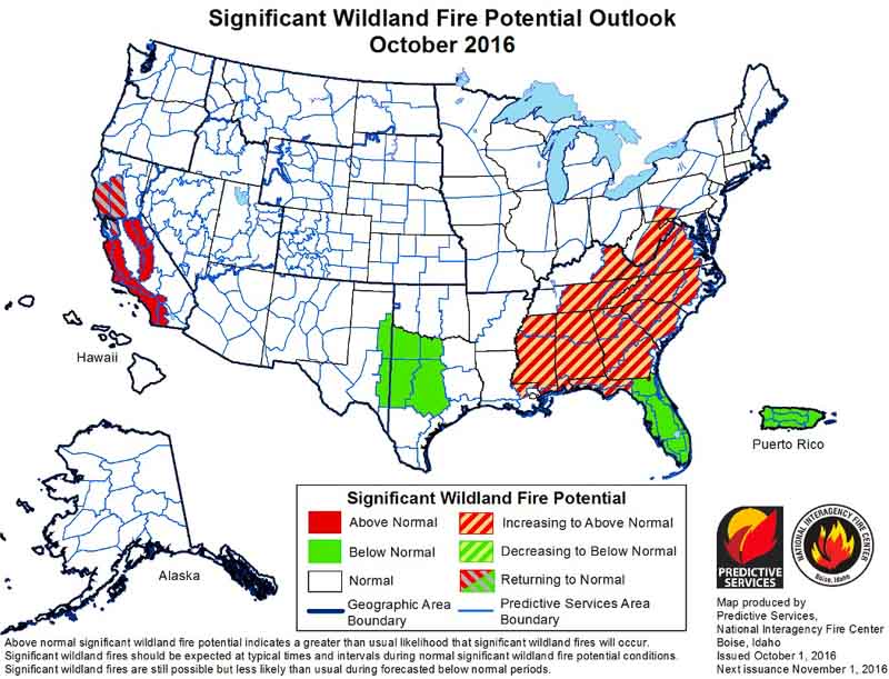
On October 1 the Predictive Services section at the National Interagency Fire Center issued their Wildland Fire Potential Outlook for October through January. The data represents the cumulative forecasts of the ten Geographic Area Predictive Services Units and the National Predictive Services Unit.

If their predictions are correct, firefighters in the mountains of central and southern California could be busy through November, at least, while most of the Southeast is coming into what could be a very active fall fire season.

wildfire potential

Scroll down to see 6 to 14-day temperature and precipitation outlooks, and Red Flag Warnings for October 2, but immediately below are highlights from the wildfire potential outlook.

****

“October represents a significant shift in fire activity in the United States. Shorter days, cooler nights and generally moister conditions reduce wildfire activity across the northern tier of the U.S., taking much of this area out of season or at least to very low fire activity conditions.

“October does represent the beginning of the primary time of concern for offshore flow across California. These dry windy conditions can lead to very significant fire events in areas with high populations. This year the forecasts indicate that offshore wind events may be less frequent than usual. However during even light wind periods fires will occur and they will have the potential to spread extremely quickly with extreme fire behavior. Fuels continue to be very dry in California due to long term drought and increased vegetation stress and mortality. Under windy conditions these fuels will become extremely volatile and can support extreme fire behavior.

“October also marks the start of the fall fire season across the eastern U.S. Leaf drop begins and adds a new dry layer of fuel. In seasons such as this one where leaf drop occurs on already dry fuels, fire activity can be amplified. Expect this to lead to increased initial attack activity and probably a slight increase in large fires. Fire activity occurs year round in the southeastern U.S. so the most likely scenario is to see an increase in frequency and the potential for more control problems than usual on fires this fall.

Continue reading “Wildfire potential, October through January”

Red Flag Warnings, September 22, 2016

wildfire red flag warning

The National Weather Service has posted Red Flag Warnings or Fire Weather Watches for areas in California, Nevada, Arizona, and Colorado.

The Red Flag map was current as of 9:15 a.m. MDT on Thursday. Red Flag Warnings can change throughout the day as the National Weather Service offices around the country update and revise their forecasts and maps. For the most current data visit this NWS site. However, that site has not been properly displaying warning areas in recent days. This one may work better.

Wildfire smoke map and Red Flag Warnings, September 12, 2016

wildfire smoke map
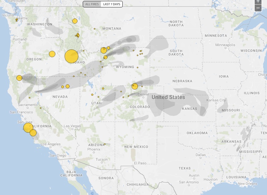
Distribution of smoke from wildfires, September 11, 2016. Ecowest.org

red flag warnings september 12, 2016

The National Weather Service has posted Red Flag Warnings or Fire Weather Watches for areas in Washington, Oregon, California, Nevada, Utah, and Colorado.

The Red Flag map was current as of 11:45 a.m. MDT on Monday. Red Flag Warnings can change throughout the day as the National Weather Service offices around the country update and revise their forecasts and maps. For the most current data visit this NWS site. However, that site has not been properly displaying warning areas in recent days. This one may work better.

Elevated wildfire danger in 11 states, September 11, 2016

red flag warnings

The National Weather Service has posted Red Flag Warnings or Fire Weather Watches for areas in Washington, Oregon, California, Idaho, Nevada, Arizona, Utah, Colorado, Wyoming, Nebraska, and South Dakota

The Red Flag map was current as of 11:45 a.m. MDT on Sunday. Red Flag Warnings can change throughout the day as the National Weather Service offices around the country update and revise their forecasts and maps. For the most current data visit this NWS site. However, that site has not been properly displaying warning areas in recent days. This one may work better.

Wildfire smoke and Red Flag Warnings, September 10, 2016

wildfire smoke map
Distribution of smoke from wildfires, September 10, 2016. NOAA.

The National Weather Service has posted Red Flag Warnings or Fire Weather Watches for areas in Washington, Wyoming, Colorado, Nebraska, and South Dakota for today.

Red Flag Warnings

The Red Flag map was current as of 9:45 a.m. MDT on Saturday. Red Flag Warnings can change throughout the day as the National Weather Service offices around the country update and revise their forecasts and maps. For the most current data visit this NWS site. However, that site has not been properly displaying warning areas in recent days. This one may work better.

Click on the maps to see larger versions.

Fire weather outlook
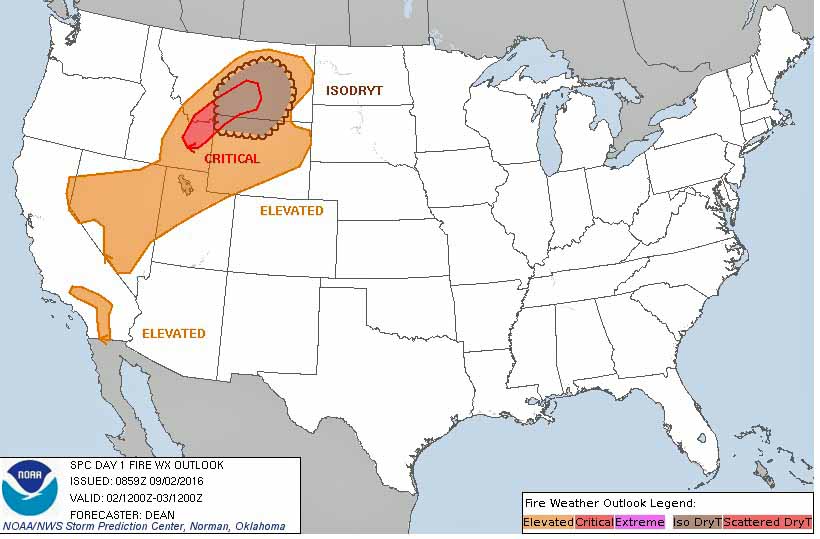
Fire weather outlook for September 11, 2016

Dry thunderstorms possible in Montana and Wyoming

Friday’s weather includes Red Flag Warnings in the west and a hurricane on the east coast

Above: Weather forecast, current at 9 a.m. MDT September 2, 2016. Weatherunderground. Black text added by WildfireToday.

The weather map for the United States today has quite a range of conditions across the country. While Hurricane Hermine, now downgraded to a tropical storm, batters the southeast, a cold front is bringing strong winds and low humidities to some areas in the west. There is a chance of isolated dry thunderstorms in northwest Wyoming and eastern Montana.

Fire weather, September 2, 2016
Fire weather, September 2, 2016.