Smoke predicted to affect San Francisco Bay area

Possibly the strongest wind event of the fall season will occur in northern California Saturday morning into Monday

forecast 4 a.m. PDT October 26 fire wildfire smoke
Forecast for the distribution of near surface smoke at 4 a.m. PDT October 26, in the San Francisco area and south as far as Santa Barbara. Click to enlarge.

UPDATED at 6:09 p.m. PDT October 25, 2019

The map above is the forecast for the distribution of near surface smoke at 4 a.m. PDT October 26, in the San Francisco area and south as far as Santa Barbara.


7:56 a.m. PDT October 25, 2019
northern california San Francisco Forecast near surface smoke western united states
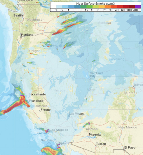
Forecast for near surface smoke in the western U.S. at 5 p.m. PDT Oct. 25, 2019

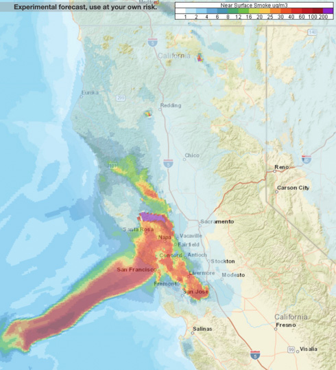
Forecasters predict that smoke from the Kincade and Tick Fires will heavily affect some locations in northern and southern California Friday. Especially affected will be the San Francisco Bay Area, from San Jose north to Santa Rosa, including the city of San Francisco.

Smoke from prescribed burning will be noticed by residents in Oregon, Idaho, and Montana.
northern california San Francisco Forecast near surface smoke northern California
Forecast for near surface smoke in northern California at 5 p.m. PDT Oct. 25, 2019

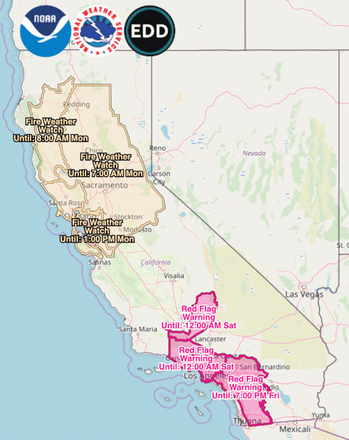
Red  Flag Warnings will continue in Southern California until Friday night.
Red Flag Warnings Fire Weather Watches
Red Flag Warnings and Fire Weather Watches, at 7 a.m. PDT Oct. 25, 2019. Times are CDT.

Very strong, dry winds are in the forecast for northern California beginning Saturday morning. This wind event which will continue into Monday is being described as “likely the strongest wind storm of the fall season” with northeast to east winds of 30 to 40 mph gusting at 45 to 70. The Watch areas in the map above will probably be upgraded to Red Flag Warnings by late Friday or Saturday morning.

(Red Flag Warnings can be modified throughout the day as NWS offices around the country update and revise their weather forecasts.)

Santa Ana Wildfire Threat Index in SoCal this week, “Moderate”

Santa Ana Threat Index
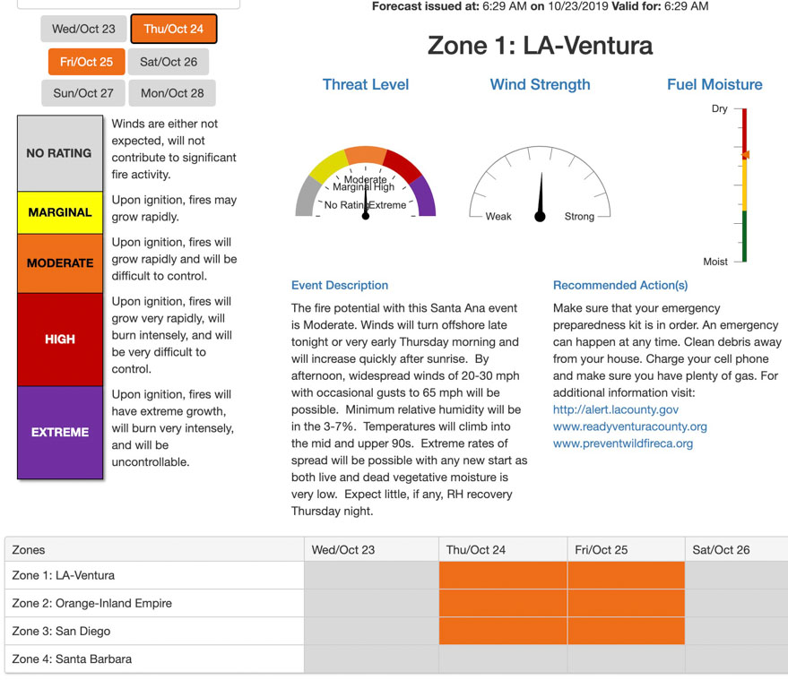
The fire threat for four areas in southern California on October 24 and 25 is described as “Moderate”. This example is for the Los Angeles and Ventura areas, showing Threat Level, Wind Strength, and Fuel Moisture on Thursday October 24.

A wildland fire danger forecasting tool called the Santa Ana Wildfire Threat Index (SAWTI) is categorizing the fire threat from the strong winds predicted for Thursday and Friday of this week in southern California as “Moderate”. This includes Los Angeles, Ventura, Orange County, Inland Empire, and San Diego. The Santa Barbara area is shown as “no rating” for this week. Most other tools for predicting fire danger would use a stronger adjective for the predicted conditions.

The SAWTI uses a predictive model that includes wind strength, dead fuel moisture, live fuel moisture, atmospheric moisture, and the greenness of annual grasses to create a daily threat assessment of the fuel conditions across Southern California. The output is then compared to climatological data and historical fire occurrence to establish the index rating. It does not assess conditions in the central or northern part of the state.

The SAWTI is a product of the US Forest Service and Predictive Services, according to the website dedicated to the tool. The site does not specify which of the numerous Predictive Services  and Forest Service offices are involved.

Red Flag Warnings
Red Flag Warnings, produced at 6:30 a.m. PDT October 23, 2019. Times are CDT.

For northern California the forecast on Thursday and Friday is for north to northeast winds of 15 to 30 mph gusting at 35 to 45 with humidity in the teens. For southern California: northeast winds of 20 to 40 gusting up to 65 with humidity in the single digits. These predicted numbers vary depending on the exact location.

(Red Flag Warnings can be modified throughout the day as NWS offices around the country update and revise their weather forecasts.)
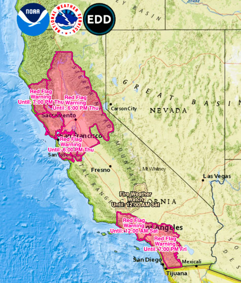
Red Flag Warnings in the forecast for California

Red Flag Warnings in California
Red Flag Warnings. NWS. (Times are CDT)

Updated: 4:27 p.m. PDT October 22, 2019

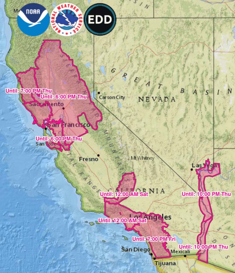
Elevated wildfire danger is in the forecast for portions of northern and southern California on Wednesday, Thursday, and in southern California, into Friday. Most of the Fire Weather Watch areas have been upgraded to Red Flag Warnings.

The extreme fire danger in northern California will begin Thursday while the southern California areas will start on Friday.

North or northeast winds at 15 to 20 mph gusting at 30 to 40 with relative humidities in the teens are predicted for the areas identified on the map in northern California. The areas in the south should receive 25 to 35 mph winds out of the north or northeast gusting at 50 to 60 with single digit humidity.

This weekend could bring another period of dry and windy conditions.

(Red Flag Warnings can be modified throughout the day as NWS offices around the country update and revise their weather forecasts.)
National Preparedness Level raised to 2

NIFC web site
Screenshot from the NIFC web site, October 18, 2019.

The week after the National Interagency Coordination Center announced they were going to stop producing the daily Situation Report and only publish it weekly, they raised the National Preparedness level to 2.

Preparedness Level 2The change occurred at 2 p.m. MDT Friday, “…due to an increase in resource mobilization, competition for resources, significant incidents occurring in multiple geographic areas and critical fire weather conditions in those geographic areas.”

As of today, October 18, fourteen active large fires have burned more than 228,000 acres in five states. Twelve new large fires were reported this week.

Firefighting resources committed to fires today:

  • 87 hand crews
  • 166 engines
  • 22 helicopters
  • 3,181 personnel

“Fire Season” is now “Fire Year”.

Red Flag Warnings
Red Flag Warnings and Fire Weather Watches, current at 6:15 p.m MDT October, 18, 2019 Click to enlarge.

(Red Flag Warnings can be modified throughout the day as NWS offices around the country update and revise their weather forecasts.)

Thanks and a tip of the hat go out to LM. Typos or errors, report them HERE.

Red Flag Warnings October 9, 2019

Above: Red Flag Warnings October 9, 2019. Times are CDT.

The areas under Red Flag Warnings are similar to Tuesdays, except Wyoming dropped out and a section of northwest New Mexico was added.

The  wind event continues in some areas of California with predictions for 15 to 30 mph winds gusting at 40 to 50 along with single digit humidity.

Pacific Gas and Electric expanded their power shutoff, increasing the number of addresses affected from 600,000 to 800,000. The company’s web site is having problems keeping up with the traffic, and is occasionally non-responsive.

(Red Flag Warnings can be modified throughout the day as NWS offices around the country update and revise their weather forecasts.)

Red Flag Warnings in six states

Above: Red Flag Warnings (red) and Fire Weather Watches (yellow), updated at 2:25 p.m. PDT Oct. 8, 2019. Times are CDT. 

Red Flag Warnings and Fire Weather Watches for gusty winds and low humidity have been posted for areas within six states. Times shown are CDT.

(Red Flag Warnings can be modified throughout the day as NWS offices around the country update and revise their weather forecasts.)