We have seen a lot of time lapse videos of the Station fire, including one we posted on August 30, but this one is much better than all the others we’ve seen. It is mesmerizing, and relaxing, even though you know that under the smoke layer, all hell is breaking loose.
UPDATE at 11:22 Sept. 2: In a comment, TJ pointed out another excellent time-lapse video.
=============
And speaking of photography, HERE and HERE are some links to some really great still photos of the So Cal fires.
HERE is another link to a great collection of fire shots, sent in by Judy.
The 121,762-acre Station fire is eating up acreage at a slower pace today, giving firefighters a chance to make a little more progress in corralling this megafire. At 3 p.m. the temperature was 93 and the humidity was 26%, which compares to 94 degrees and 19% yesterday at the same time. The wind yesterday was blowing at 11 mph, while today at the same time it was measured at 5 mph.
The order of the day was to burn out the fuel between the edge of the fire and the urban interface in the front country on the south side of the fire in the La Crescenta, Montrose, and Altadena areas. Many firefighters were committed to this effort which put up a lot of smoke but helped to secure some of the fire perimeter.
On Mt. Wilson firefighters were able to access the area again after having to leave earlier due to safety concerns. They conducted some burnouts near the communications facilities to construct a buffer for when the main fire approaches.
For most of the day dense smoke around Mt. Wilson prevented air tankers from making drops in the area, but the 7,200-gallon, water-scooping Martin Mars was ordered from its Lake Elsinore base with the assignment of “making it rain” around Mt. Wilson. And at 4:15 p.m. it made a drop, dodging the communications towers.
We will post an updated map of the fire if new fire perimeter data becomes available later today.
We replaced the satellite map with an updated one.
============================
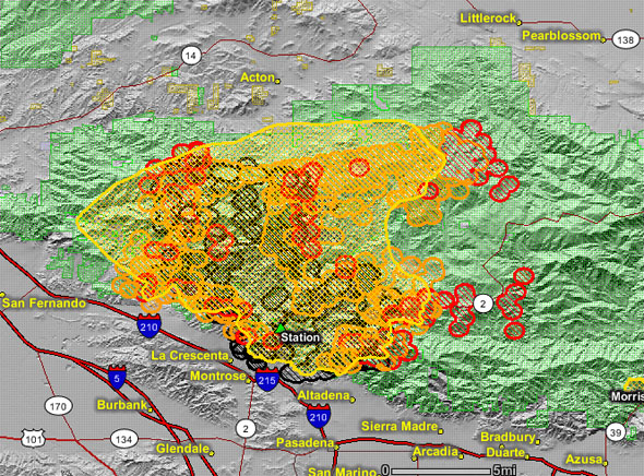
This map of the Station fire shows heat detected by satellites at 3:45 a.m. 1:05 p.m. PT Sept. 1. The red areas contain heat that was detected within the previous 12 hours. The yellow area is the latest fire perimeter provided by the incident management team working on the fire; it is an estimate.
The map below is more user-friendly and can be zoomed in and out or panned. Made by the good folks at NorthTree Fire, it uses the latest fire perimeter described above, but is not quite as current as the satellite map. View Larger Map
The incident management team estimates the size of the Station fire to be 121,762 acres with 5% containment. Moderate weather and higher humidities Monday night resulted in decreased fire activity. On Tuesday the winds will shift from out of the northeast to the southwest in the afternoon and increase to 30 mph on the ridgetops later in the day. We can expect to see increased fire activity on the northeast side again in the afternoon as these winds appear. However the temperatures will be slightly lower and the humidity higher as an onshore flow affects the fire.
There is a possibility of thunderstorms in the area today which could produce locally strong winds, causing the fire to spread erratically in unpredictable directions. The storm could also bring dry lightning, which is something the firefighters don’t need right now.
Fire crews conducted a number of successful burnout operations on the west side on Monday, including the Glendale, Tujunga, and the Santa Clara ridge areas. They will continue to secure those areas today.
At Mt. Wilson, which has extensive communications facilities and fire on two sides, fire crews had to pull out of the area, since the only road to the peak is surrounded by fire, compromising the firefighters’ escape route.
In the photo above, fire personnel examine the scene of the accident that killed two Los Angeles County Fire Department firefighters, Tedmund Hall, 47, and Arnaldo Quinones, 34. Photo by Al Seib, August 31, 2009.
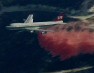
Evergreen’s 747 “Supertanker” made its first drop on a live fire in the lower 48 states today. Flying out of McClellan near Sacramento it made at least two drops on the Station fire. It split its 20,000 gallon capacity into two separate drops of about 10,000 gallons each, without having to make the 55-minute one-way return trip to McClellan to reload.
The Fox TV station out of Los Angeles got two of the drops on tape. Click on the image below to play the video. (UPDATE: the video is no longer available)
The plane may also have dropped earlier in the day on a fire near Yucaipa, southeast of Los Angeles.
As Wildfire Today reported on July 30, the 747 made its first drop on a live fire in Spain in mid-July. The second fire it dropped on was the Railbelt Complex in Alaska on July 31. If it also dropped on the Yucaipa fire earlier today, then the Station fire was the fourth fire it has dropped on.
Here are a couple of screen grabs from today’s video.
Below is the photo of the 747 on the Railbelt Complex in Alaska on July 31 that we published on August 1.
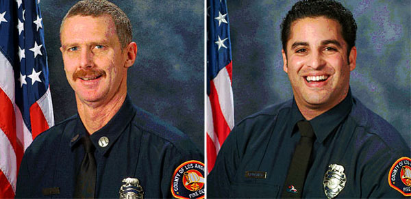
At a press conference today Mike Bryant, Deputy Fire Chief the Los Angeles County Fire Department, provided some preliminary information about the deaths of the two firefighters we reported on August 30.
Captain Tedmund D. Hall, 47, and Firefighter Specialist Arnaldo Quinones, 35, (left to right above) were working with 65 other firefighters attempting to protect Camp 16 from the Station fire. As the fire got near the camp, Quinones and Hall got into a pickup truck in order to reposition it. Somehow during that repositioning the truck left the road and tumbled down the slope, ending up 800 feet below the road.
Photo: Jason Redmond
The fire overran Camp 16 (above) totally destroying the facilities, according to the Chief Bryant. “Many” firefighters suffered minor burns and smoke inhalation, but all were treated and released.
There will be a formal inquiry, including a serious accident review.
Services are being planned for Quinones and Hall, but have not yet been finalized.
Again, our condolences go out to the families and co-workers.
This updated map of the Station fire shows heat detected by satellites at 12:26 p.m. on Monday, August 31. Most of the new fire growth, compared to the map we posted earlier Monday morning, is on the east side, and appears to show spot fires quite a distance out ahead of the main fire.
The red areas show heat that was detected within the previous 12 hours. The yellow area is the fire perimeter as provided by the fire officials. GEOMAC
The size of the fire, as we reported earlier Monday afternoon, is estimated at 105,000 acres.
This fire has produced a lot of incredible photos. Here is one that the LA Times distributed via Twitter. We don’t know who the photographer was. We were informed by a commenter that the photographer’s name is Wally Skalij.