Station fire doubles in size overnight

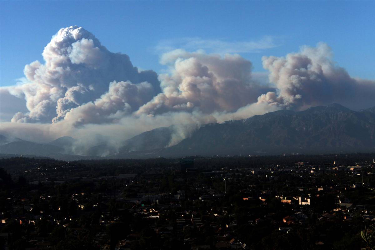
The Station fire near Los Angeles doubled in size Sunday night to an estimated 85,760 acres.  It is a fatal fire, after two firefighters, Arnaldo Quinones, 35, of Palmdale and Tedmund Hall, 47, of San Bernardino County were killed when they drove off the side of a road south of Acton around 2:30 p.m. on Sunday. The firefighters worked for Los Angeles County Fire Department.

The map of the Station fire shows heat detected by satellites Monday morning at 3:02 a.m. The red areas show heat that was detected in the last 12 hours. The yellow line is the fire perimeter provided by the Incident Management Team.

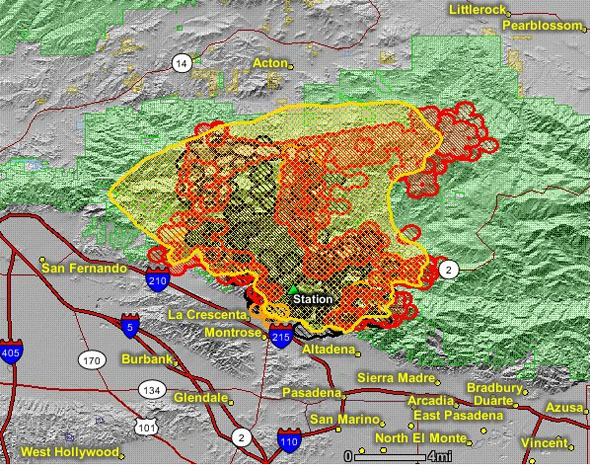
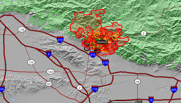
Only about 5% of the fire is contained, a small section of the fire perimeter near Altadena.

More structures were destroyed south of Acton overnight and Monday morning, adding to the 18 homes that burned in Big Tujunga Canyon earlier. The exact numbers will not be known until firefighters can get back into the burned areas to conduct damage assessments.

More residents were forced to evacuate overnight as the fire spread on three sides, making large advances on the west, north, and east sides. It is still about 2-3 miles from Acton on the north, and has come to within 7-8 miles of Littlerock and Pearblossom on Highway 138 on the northeast side.

At least 6,600 homes were under evacuation orders Sunday night. Residents are being told to call 211 to get the latest evacuation information.

The photo above shows the west flank of the Station fire near La Cresenta Valley, at 8:57 PT Monday morning. The fire is beginning to break through an inversion. From the local Fox TV station.

While most large fires in southern California are driven by Santa Ana winds, this fire, while occasionally influenced by moderate winds, is primarily driven by steep slopes, heavy vegetation or fuel loading, and extreme weather, including high temperatures and very low humidity.

Wildfire Today explored this concept in an August 26 article. During the last 130 years, through 2007, six of the eight “megafires”  larger than 123,000 acres (50,000 ha) were pushed by Santa Ana winds during the first one to four days. The other two megafires were influenced by extreme weather, much like we have seen in southern California since Tuesday, August 25.

There is not going to be much relief from the extreme weather during the next two days. In the valley areas near the fire, temperatures will be in the mid to high 90s with relative humidity in the low teens, which is a little better than the last several days. Winds will be moderate, maxing out at 9-10 mph out of the southwest.

One of the best fire photos ever

A P3 Orion drops on the Station fire Aug. 30 near Acton, California. Photo: Dan Steinberg

This photo is one of the best fire photos I have ever seen. When I first saw it, I thought it was a great photo with plenty going on–the two fire vehicles, massive nearby flames, the house, and the firefighters–and then noticed the air tanker making a drop between the house and the intense flames. Holy Crap! What a photo!

This one is pretty impressive too, of the Station fire near Los Angeles:

Photo: Nick Ut

Two LA County firefighters killed in vehicle accident on Station fire

In a news conference late today officials announced that two firefighters with the Los Angeles County Fire Department (LACFD) died today in a vehicle accident while working on the Station fire near Mt. Gleason in southern California. The accident happened earlier this afternoon, and the families of the fallen firefighters have been notified, they said at the news conference.

Details about the accident were not provided, but television footage showed a truck that had rolled over.

At 6:52 p.m. PT the LACFD Tweeted:

lacfd *Station IC* Report of fire department vehicle over the side 400+ feet with unknown outcome. Copters unable to get in to search. Keep them in our prayers.

Our sincere condolences to the families and co-workers of the firefighters.

We will update this as more information becomes available.

Updated map of Station fire, Aug. 29

UPDATE at 9:25 p.m. PT, Aug. 29

Fire personnel provided this map Saturday night. It is difficult to see much detail, but it might help those that live nearby.

(end of update)

=================================

This is a NEW updated map of the Station fire near Los Angeles is below. It shows heat detected by satellites at 2:17 p.m. PT today, August 29. The red areas depict heat detected within the last 12 hours. It shows a great deal of fire growth, especially on the west and north sides as it burns deeper into the Angeles National Forest and threatens homes in the front country.

The fire has burned into across Big Tujunga Road and west over Mt. Lukens. It threatens homes in La Canada -Flintridge, Altadena, and Glendale.

Southeast winds at 6-12 mph contributed to the spread toward the northwest on Saturday. The potential exists for Sunday’s fire behavior to be similar to that seen on Saturday.

Firefighters report that the fire has burned 20,102 acres and it is 5% contained.

Station fire map, 14:17 p.m., Aug. 29. Data from GEOMAC.

Information from the LA Times:

The Station fire was spreading rapidly to the east and west this afternoon, prompting evacuations in La Cañada Flintridge, Glendale, Altadena and Big Tujunga Canyon as temperatures reached triple digits.

Los Angeles County Fire Department dispatcher Melanie Flores told The Times that two people were being treated for burns at the Big Tujunga ranger station, though more details were not immediately available.

The Station fire has now burned more than 20,000 acres, according to fire officials.

The latest evacuation zone is in the remote upper reaches of Big Tujunga Canyon near the ranger station, according to the California Department of Forestry and Fire Protection. The city of Glendale also ordered evacuations north of Santa Carlotta Street between Pennsylvania and Lowell avenues. The city of Pasadena advised residents of the Florecita neighborhood in the far northwest of the city to evacuate their homes voluntarily.

Temperatures topping 100 degrees, single-digit humidity and the steep, rugged topography of the Angeles National Forest continue to make the fire a formidable foe despite low winds, fire officials said today.

Update on southern California fires

Wally Skalij photo. August 27, 2009.

Here is an update on the four major fires currently burning in southern California. (Some of the key numbers and facts for the Cottonwood and Station fire were updated at 3:43 p.m. and 7:20 p.m. August 28.)

  1. The Station fire started on the Angeles Crest Highway, above La Canada Flintridge in the Angeles National Forest. It has burned 1,200 5,000 5,500 acres, is very active, and is 0% 5% contained. The fire jumped Highway 2 and into the Arroyo Seco area overnight. It is threatening Mount Wilson, which has major communications facilities. It is burning south and west towards the city of La Canada-Flintridge, West towards Mt. Lukens, North towards Grizzly Flat Road, East toward Arroyo Seco, and Dark Canyon. Some voluntary evacuations are in effect for the northern portions of La Canada-Flintridge. Dietrich’s Type 1 Incident Management Team has been mobilized for this fire.
  2. The Morris fire near Azusa has burned about 2,000 2,168 acres and is 60% 85% contained. Ron Woychak’s Incident Management Team is assigned.
  3. The RPV (or PV) Portuguese fire in the Rancho Palos Verdes area started Thursday night and has burned about 100 125 230 acres and damaged two outbuildings. It is 35% 70% 90% contained. The fire will be more accurately mapped this morning and the acreage and containment will change. This fire burned very intensely in an urban setting and the fact that only two outbuildings were damaged is due to good fire clearance around the homes, night-flying helicopters, and great efforts by firefighters.
  4. The Cottonwood fire east of Hemet has burned 1,000 1,200 2,200acres and is 5% 10% contained. Forella’s Wakoski’s Incident Management Team has been ordered assumed command of the fire at noon today. Los Angeles live television this morning showed firefighters conducting some very effective burnouts in the relatively flat terrain, aided by gentle winds. The Martin Mars air tanker is making drops this morning.

The LA Times has an unofficial map showing all four fires (if you zoom out).

Station fire. Photo: InciWeb

Night-flying helicopters were very effective Thursday night on the Portuguese fire in Rancho Palos Verdes. They were using two from LA County and three from the LA Fire Department. As far as we know these are the only two agencies in the United States that use helicopters at night for fighting fire. San Diego County was considering night flying for their helicopters; we’re not sure if they got that program running.

Four major wildfires burning in southern California

The red flag warning that was issued for Wednesday through Friday for the mountain areas north of Los Angeles has led to four major wildfires that are currently burning in the area.

  1. The Station fire on the Angeles Crest Highway, above La Canada Flintridge in the Angeles National Forest, started Wednesday afternoon. We had a photo from that fire earlier. It is threatening the Angeles Crest U.S. Forest Service fire station on the highway. It has burned at least 500 acres and is very active. About 500 homes were evacuated Thursday night. It is 5% contained.
  2. The Morris fire near Azusa started on Tuesday and has burned about 2,000 acres and is 60% contained.
  3. The RPV (or PV) Portuguese fire in the Rancho Palos Verdes area started Thursday night and has burned at least 75 acres and at least two to three structures, including one of a retired firefighter. Many other structures are threatened and evacuations are under way.
  4. The Cottonwood fire east of Hemet started Thursday afternoon has burned 400-600 acres. An incident management team has been ordered.

These fires are driven by single-digit humidities and record high temperatures. There is so little wind that the smoke is hanging in the basins, mixing with the normal smog, and creating awful air quality.