Use an app to send precipitation observations to the NWS

Many areas where wildland firefighters are working do not have great coverage from weather radar because of the distance from the transmitter or steep terrain blocking the signals. You can help the National Weather Service produce better forecasts by using an app on your phone that can let them know what is happening at your location.

The message below from the National Weather Service in Rapid City uses local examples, but the principles are relevant in other areas:

****

Want to be a citizen scientist and help us determine what type of precipitation (snow, rain, sleet, hail, etc.) is falling?

Download the mPING app and use it to report various precipitation types as they occur. This data is incredibly helpful, especially because the terrain in SD and WY impacts radar coverage (can make it difficult to know what is happening at the surface far from the radar location in New Underwood, SD). Determining precipitation type can be rather tricky without observations at the surface. This is especially true when the temperature is just right that some places receive rain, while others get snow. That’s where the power of mPING comes in handy!

All reports are anonymous – only the location (latitude/longitude), time, and precipitation type are recorded.

The app can be downloaded on Android and iOS devices. If you have any questions, feel free to contact us or check out the mPING FAQ. We appreciate your willingness to help!

Links to the app here: http://mping.nssl.noaa.gov/

mPING FAQ: http://mping.nssl.noaa.gov/faq.php

Atmospheric river brings extreme wind and precipitation to northern California

Atmospheric river
Atmospheric river funnels moist tropical air into northern California.

The atmospheric river of moist tropical air being funneled into northern California continues to dump very large amounts of precipitation in areas suffering from five years of drought.

The rain began Wednesday, January 4 and is predicted to continue at least into Wednesday of this week. Some areas have received between 5 and 9 inches of precipitation since Friday.

Atmospheric river extreme precipitation
Storm total precipitation in selected northern California locations, 5 p.m. Friday 1/6 through 5 p.m. Sunday 1/8.

The National Weather Service office in Reno, Nevada reported that multiple wind sensors recorded gusts Sunday morning that exceeded 170 mph.

Atmospheric river extreme wind
Extreme winds gusting above 170 mph were reported by the National Weather Service office in Reno, Nevada, Sunday January 8, between 6:45 a.m. PST and noon. Posted by the NWS at about noon local time on Sunday.

Some areas in the Sierra Nevada mountains could see another 3 to 7 inches of precipitation between Monday and Wednesday. Flooding is being reported in many areas.

Atmospheric river extreme precipitation
Precipitation forecast for northern California Monday 1/9 through Wednesday 1/11.

National Park Service officials evacuated the valley in Yosemite National Park Friday except for essential personnel.

Continue reading “Atmospheric river brings extreme wind and precipitation to northern California”

Wildfire potential, January through April

With huge amounts of rain and snow hammering California and Oregon, few people in those areas are thinking about wildfires this week.

But in spite of the rain delivered to the west coast on what meteorologists are calling an “atmospheric river”, on January 1 the Predictive Services section at the National Interagency Fire Center issued their Wildland Fire Potential Outlook for January through April. The data represents the cumulative forecasts of the ten Geographic Area Predictive Services Units and the National Predictive Services Unit.  If their predictions are correct, in February wildfire activity could begin to pick up in parts of Texas, Oklahoma, Kansas, and New Mexico, with Florida and Georgia getting busier in March and April.

Below are the highlights of their report. Following that are outlooks for February through April, temperature and precipitation forecasts, and the Drought Monitor.

****

“To begin 2017 significant wildland fire potential will be normal throughout entirety of the United States, except for below normal in Puerto Rico. For the majority of the U.S. this normal condition means that significant wildland fires are unlikely and normal indicates an out of fire season condition.

Beginning in February the seasonal increase in wildland fire activity will begin in the southern plains where the combination of abundant fine fuels and the potential for dry and windy conditions will occasional come together to produce periods of significant fire activity impacting the Southwest, Rocky Mountain and Southern Areas.

After February predictions for significant fire activity become increasingly difficult. It is likely that the same fire potential will continue across the southern plains, but pregreen up fires will also become increasingly likely in a large portion of the U.S. These fires are difficult to predict and rely on short term localized significant weather events.

Also during this period it is likely that we will see the onset of fire activity in south central Alaska, where warmer and drier than typical winter conditions are occurring.

Significant fire potential will also increase to above normal in Florida and portions of Georgia. Long term drought remains the primary concern in this area and moisture deficits in this area are likely to lead to occasional fires that burn deep into the soil layer and are more difficult to suppress.”

****

Continue reading “Wildfire potential, January through April”

Huge amounts of precipitation expected in the Sierras

A weather system meteorologists are calling an “atmospheric river” is bringing massive amounts of rain and snow to California.

precipitation forecast
Seven-day precipitation forecast for the period beginning early Wednesday morning.

As a high pressure system over the west coast moves out of the way, massive amounts of precipitation are being funneled into California and Oregon. As orographic lifting squeezes the moisture out of the air mass some areas in the Sierras could receive up to two feet (24 inches!) of precipitation before this event is over. If most of it falls as snow in the mountains, the peaks in the Sierras could see up to 10 feet of snow.

It has already started, as you can see in the graphic below showing the snow received as of Wednesday morning. And the storm has just begun.

snow reports Sierras

It remains to be seen how this will affect California’s five-year drought and the 2017 fire season. In 2016 the northern part of the state saw some relief from the drought, but there was not much change farther south.

Amid predictions of an unusually warm and dry summer, temperatures in Sydney soar to highest in 11 years

Above: The chance of above median maximum temperature in Australia, December through February.

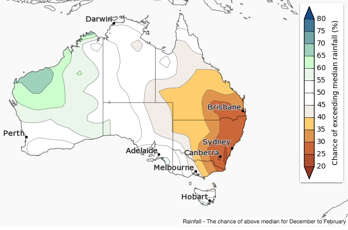
The Australian Bureau of Meteorology is predicting that the eastern half of their country will experience a summer that is warmer and dryer than normal. That season is just beginning; their highest temperatures usually occur in January and February, but Tuesday produced the hottest December day in Sydney in the last 11 years, hitting 39.2C (102.5F) at Sydney Airport.

australia precipitation
The chance of above the median rainfall in Australia, December through February.

Below is an excerpt from an article at Australia’s ABC News about how Tuesday’s weather could affect wildfires:

Fire danger warnings are in place across a large part of Australia, with hot temperatures and windy weather expected, the Bureau of Meteorology (BOM) says. Fire authorities are on alert in the south-eastern states, with total fire bans in place in regions of South Australia, New South Wales and Victoria, and a high danger in Tasmania.

Temperatures were forecast to reach the mid-30s in the southern states, with a maximum of 36C in Sydney and Adelaide, 34C in Melbourne and 33C in Canberra.temperature conversion

In Darwin, the maximum expected temperature was 34C, 29C in Hobart. Perth’s forecast top was a cooler 26C and Brisbane 29C.

High temperatures in several capital cities at the same time is “a bit different”, senior BOM meteorologist Claire Yeo said.

“Those hot temperatures ahead of that wind change [are] increasing the fire dangers into that very, very high to severe range,” Ms Yeo said

“But there is also an added impact that we don’t necessarily or aren’t necessarily able to reflect in the fire danger rating, and that’s the way the atmosphere behaves in these kinds of conditions.

“Today is a classic example where if a fire was to start in your particular area, the atmosphere is primed for [it]. If a smoke plume develops over that fire, it can get to quite an extensive height … and we see very erratic fire conditions and fire behaviour in that kind of atmospheric condition.”

Ms Yeo said more frequent fire danger ratings were expected in coming days.

Wildfire potential, December through March


On December 1 the Predictive Services section at the National Interagency Fire Center issued their Wildland Fire Potential Outlook for December through March. The data represents the cumulative forecasts of the ten Geographic Area Predictive Services Units and the National Predictive Services Unit.

If their predictions are correct, the elevated wildfire danger that has plagued the southern states for weeks will be returning to normal. From January through March their analysis shows no areas with above normal wildfire potential.

January wildfire outlook

Continue reading “Wildfire potential, December through March”