Wildfire potential, April through July, 2013

The Predictive Services section at the National Interagency Fire Center has issued their Wildland Fire Potential Outlook for April through July, 2013.

Beginning in February of this year they changed their legend, unfortunately, so now, for me anyway, it is difficult to compare the tiny little boxes in the legend with the corresponding areas on the maps. Or perhaps it’s just the way my computer monitor renders colors. But check out the May map below, for example, and especially the legend codes for “Returning to Normal” and “Decreasing to Below Normal”. Maybe if they varied the direction of the cross-hatching and used colors that were not quite so similar it would help. This reminds me of a National Weather Service product that uses seven shades of light brown in their legend.

(UPDATE: April 2, 2013: I received a call from Ed Delgado, NIFC’s Predictive Services manager, who said he read the above, and agrees that the colors and/or legend needs to be improved. Next month’s report, he said, will be easier to interpret.)

Below is an excerpt from their report, followed by maps:

****

April

  • Significant fire potential will increase over most of Florida as lingering drought keeps fuels dry.
  • Most of the East and Gulf regions will have below normal significant fire potential as active storm patterns keep conditions wet and cool.
  • Cool and wet conditions will keep southern Alaska significant fire potential below normal.

May

  • Significant fire potential will remain above normal over most of Florida.
  • Significant fire potential will increase across western Minnesota and western Iowa as wet and cool conditions return to normal.
  • Drought conditions will increase significant fire potential to above normal over parts of New Mexico and Arizona.

June and July

  • Significant fire potential will be above normal in mountains and foothills of southern California.
  • Significant fire potential will increase to above normal over northern California and the Northwest.
  • Significant fire potential will decrease to normal in Florida, Minnesota, Iowa, New Mexico and Arizona.

Wildfire potential, April, 2013 Wildfire potential, May, 2013 Wildfire potential, June-July, 2013

South Dakota fire meteorologist analyzes wildfire potential

Percent of normal precipitation, Dec-Feb

South Dakota State Fire Meteorologist Darren Clabo gave a presentation in Rapid City Thursday covering the current fire weather conditions and the potential for the coming months. Below is an excerpt from an article in the Rapid City Journal:

April, May, June and July are typically the region’s wettest months, when the area receives 50 percent of its annual average of 21 inches precipitation. With the exception of the Northern Hills and northeastern South Dakota, most of the state had no appreciable snow pack this winter after a warmer-than-average summer that depleted soil moisture, Clabo said.

“My biggest concern is the southern Black Hills, southwestern South Dakota, down to the Pine Ridge Escarpment,” Clabo said. “I’m concerned about western South Dakota. I’m concerned about the Missouri River Valley.”

Last year, much of the Northern Great Plains and Rocky Mountain regions saw less than 50 percent of their average rainfall. Temperatures were also 3 to 5 degrees above average.

“2012 was the hottest year on record in North America. That’s extreme,” Clabo said.

And, there are indications that a warm spring and summer are on the horizon, Clabo said.

Although an improvement in drought conditions is predicted, Clabo is less than optimistic about the possibility of any significant drought relief. He points out that most of western South Dakota is in an extreme or severe drought, according to the national Drought Monitor.

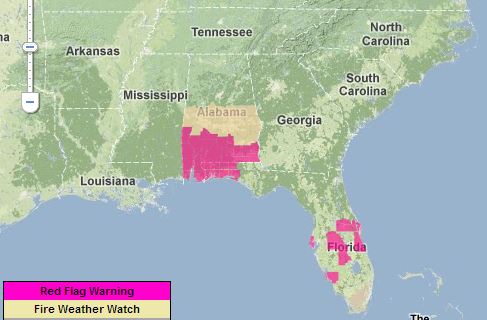
Red Flag Warnings, March 27, 2013

Red Flag Warnings

Red Flag Warnings and Fire Weather Watches for enhanced wildfire danger have been issued by the National Weather Service for areas in Alabama and Florida.

***

The map above was current as of 10:10 MT on Wednesday. Red Flag Warnings can change throughout the day as the National Weather Service offices around the country update and revise their forecasts. For the most current data, visit this NWS site.

Seasonal drought outlook through June 30

Seasonal Drought Outlook

The National Weather Service has released an updated Seasonal Drought Outlook for March 21 through June 30, 2013.

Their description:

****

Latest Seasonal Assessment – The drought outlook for March 21 – June 30, 2013 is based primarily on short-, medium-, and long-range forecasts, initial conditions, and climatology. Since the release of the previous drought outlook issued on March 7, 2013, the largest drought improvement occurred across the middle to upper Mississippi Valley and the Ozark region. Improvement is forecast to continue across these areas and extend northwest to include much of the Dakotas and Minnesota. Some improvement is forecast for the most intense drought areas of the central and southern Great Plains. Prospects for drought improvement decrease further south across the southern high Plains and Texas. Drought is forecast to persist for much of the West and expand across northern California and southern Oregon. During the past two months, major improvement occurred across Georgia and South Carolina where additional improvement is expected. Drought is forecast to persist or develop across the Florida peninsula but it will likely be short-lived as the rainy season typically begins during June. Some improvement is expected for the smaller areas of drought across northern Alaska and the Hawaiian Islands.

Forecaster: B. Pugh

Red Flag Warnings, March 26, 2013

Red Flag Warnings

Red Flag Warnings for enhanced wildfire danger have been issued by the National Weather Service for areas in Alabama and Florida.

***

The map above was current as of noon MT on Tuesday. Red Flag Warnings can change throughout the day as the National Weather Service offices around the country update and revise their forecasts. For the most current data, visit this NWS site.

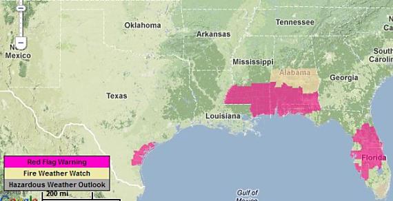
Red Flag Warnings, March 25, 2013

Red Flag Warnings

Red Flag Warnings and Fire Weather Watches for enhanced wildfire danger have been issued by the National Weather Service for areas in Texas, Mississippi, Alabama, and Florida.

***

The map above was current as of 9:30 a.m. MT on Monday. Red Flag Warnings can change throughout the day as the National Weather Service offices around the country update and revise their forecasts. For the most current data, visit this NWS site.