Fire tornado in North Dakota

Sometimes large fire whirls over wildfires, spinning columns of air, debris, and sometimes flames, are called “fire tornadoes”. If they are on or close to the ground the more accurate term is most likely “fire whirl”. We have reported on them before, including one in Hawaii. We even posted a picture of the tracks of dust devils, spinning air not associated with a fire, on Mars. Yes, Mars.

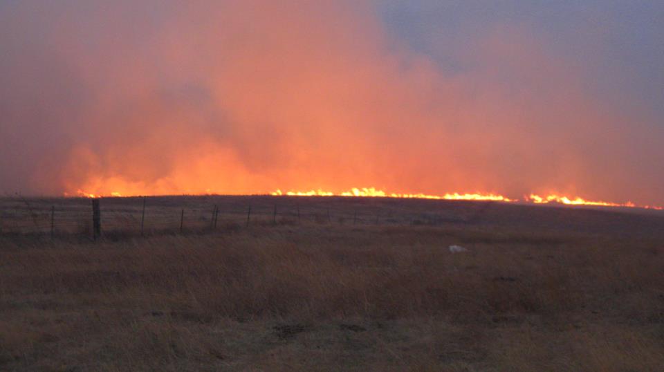
Fire tornado, North DakotaWhen Kelly Schwartz was driving home after getting gasoline in his vehicle on October 24, 2011, near Langdon, North Dakota he spotted a smoke column over a vegetation fire. Being a photographer, he pulled out his camera and started taking some pictures. The smoke, back-lit by the afternoon sun, made for some good photos. But then he saw something unusual in the smoke.
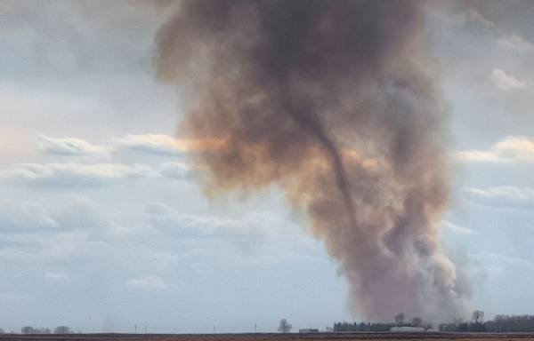
Fire tornado, North DakotaThe photos are published here with Kelly’s permission.

He said on his blog:

…I start to notice this tornado looking thing in the smoke. I found an approach and snapped some more pictures. 10 minutes later I arrived at fire, but it had died down quiet a bit and wasn’t producing as much smoke and the tornado looking thing was gone.

Kelly sent the photos to the National Weather Service to get their opinion on what he had seen. Here is an excerpt from their analysis, written by Gregory Gust, NWS Warning Coordination Meteorologist:

===========================================================

“…Why did this “Fire Tornado” occur?

A Fire Whirl generally forms when superheated air near the surface of a large fire zone rises rapidly in an airmass where sufficient horizontal or vertical vorticity is also present. Much like a dust devil or whirlwind, the rapidly rising air above a wildfire can accelerate and turn the local vorticity into a tight vertical vortex, now composed of fire instead of dust. Whereas the dust devil will often mix out its local temperature discontinuity and the vortex dissipate rather quickly, over a few minutes or less, the wildfire zone can help maintain a fairly long-lived fire whirl lasting for several minutes or more.

A Fire Tornado would be a much more extreme example, and involve a Fire Whirl that had stretched vertically from the ground up to the base of developing cumuliform clouds. In our case, the vortex extended nearly 3900 feet high.

What’s the Meteorology behind all of this?

A below listed article by Mike Umscheid, with the NWS office in Dodge City KS, has a great meteorological explanation and example of how this process initiates.

Our detailed analysis of the Langdon event will take some time to complete, but preliminary information suggests that similar ingredients are present as follows: 1. the fire zone heating produced the rapidly rising air, 2. the lower level winds had enough environmental shear to induce a vertical vorticity near the surface and get the fire whirl going, and then sustain it.

In addition, we suspect that at least two additional factors were in play, as follows: 3. low level moisture was sufficient to rise, cool, condense and form the pyro-cumulus cloud deck, and 4. the lifted condensation level (LCL) was close enough to the level of free convection (LFC) so that the developing pyro-cumulus quickly became a towering cumulus… which may have increased the overall up draft speed and vertical vorticity to such an extent that the near surface Fire Whirl stretched into a Fire Tornado.

The 2:55 p.m. CDT report from the Langdon Airport listed winds at 3 mph from the east, with visibilities reduced to 1.25 miles in haze, and lowest cloud heights of 3700 to 3900 feet AGL. The next published observation, at 3:15 p.m. CDT, listed winds as calm, visibilities as unrestricted (10 miles or greater), and skies as overcast at 3900 feet AGL.

According to local observers, the pyro-cumulus cloud developed quite quickly above the fire zone as the ascending smoke plume then took on its whirl.”

Winds push large fires across South Dakota and Nebraska

Okreek fire in South Dakota
Okreek fire in South Dakota. Photo: Kathie Cole

Strong winds have pushed large fires across the plains of South Dakota and Nebraska over the last two days. The largest, the Okreek fire between Winner and Mission in South Dakota has burned 7,500 acres and is 22 miles long. Spokesperson Jeni Lawver told us at 10:35 a.m. today that there were no evacuations in effect and there have been no serious injuries. Joe Lowe’s Type 2 Incident Management Team assumed command of the fire at 10:00 a.m. on Thursday. At least some of the fire is on the Rosebud Indian Reservation.

A reporter for KELO television said the winds were so strong that it made it difficult to stand. The weather forecast offers little relief and calls for 33 to 41 mph winds out of the northwest with gusts up to 57 mph on Thursday. There is a 19% chance for thunderstorms Thursday afternoon, increasing to 40% Thursday night.

Okreek fire in South Dakota
Okreek fire in South Dakota. Photo: Kathie Cole

There are media reports that two firefighters from Yankton, SD were injured on a fire in Nebraska’s Cedar County, but they are reported to be in good condition after receiving medical treatment. Another report says a firefighter from Kennebec, South Dakota suffered minor burns and smoke inhalation while working on a fire in Lyman County. The “Harvest CA” fire, five miles south of Stapleton, Nebraska, has burned 7,000 acres.

Wildfire potential, October 2011 through January 2012

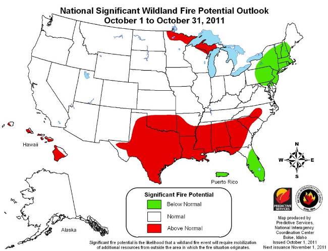
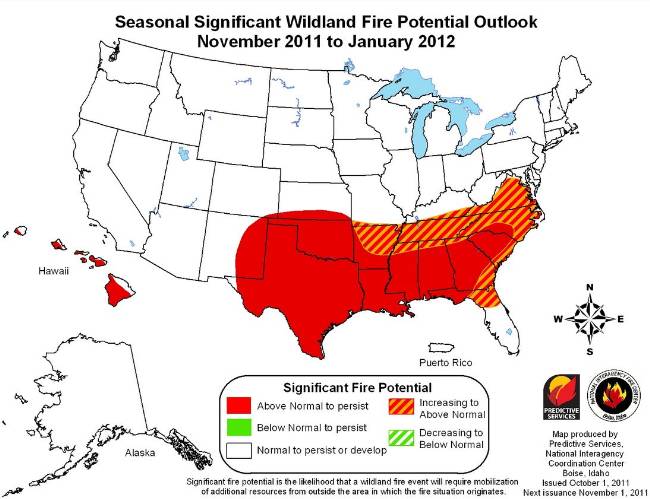
The Predictive Services section at the National Interagency Fire Center has issued their National Wildland Significant Fire Potential Outlook for October, 2011 through January, 2012. According to their prediction, most of the United States is in for a quiet autumn and early winter with the exception of the southeast.

Wildfire outlook October 2011Wildfire outlook November 2011 through January 2012

According to NIFC, the primary factors influencing these outlooks are:

  • La Niña: La Niña conditions have redeveloped, as evidenced by a marked cooling of the equatorial Pacific. It is not unusual to have a second La Niña after one of such magnitude as the 2010-11 event. However, the impacts may be greater given the degree of drought across much of the south central and southeastern U.S.
  • Drought: Extreme to exceptional drought will persist across Texas, eastern and southern New Mexico, Oklahoma, southern Kansas, western Louisiana, Georgia and western South Carolina.
  • Fuel Dryness: A significant change in fuel conditions occurred across much of the west in the latter part of September. Cooler temperatures and increasing humidity coupled with shorter days and burning periods caused indices and fuel moistures to dip to normal or below normal. Even with short warming and drying periods much of the West will not return to any significant conditions or level of concern this season. The exception may be Southern California where near normal conditions currently exist and offshore wind events remain possible through the fall. Drought conditions persist across a portion of the Great Lakes region, however with recent moisture and decreasing temperatures, fuels will not likely recover to the point of causing above normal significant fire potential after the early portion of October. Drought will persist and worsen across much of the southern U.S. from Texas through North Carolina. With leaf fall already underway and significantly below normal precipitation likely, fuel conditions will continue to be critical. The lee side of the Hawaiian Islands will also remain in a drought and fuels conditions will continue to be dry.

Previous wildfire potential outlooks.

And, don’t forget about the fire weather forecast for the next 10 years we posted earlier.

Fire weather forecast for … the next decade

Wildland firefighters usually follow the weather forecasts religiously, so I was interested to find in the Southern Area Coordination Center Morning Report for Friday, September 30, 2011 in addition to the standard short range forecast an extremely long range forecast for the next 10 years:

An Even Longer Range Outlook Beyond 2011 Into the Next Decade: Given the abnormally low solar activity in combination with cold sea surface temperatures in the tropical Pacific and the trend for La Nina episodes to be stronger and longer, the Southern Region can expect more frequent and prolonged drought conditions. This will amplify fire potential in the South for the next 10 or so years. The fire problem will likely be particularly poignant for Oklahoma and Texas. Drought conditions that are occurring in Texas currently are comparable to those of the mid 1950s as well as the later 1800s during the Dalton Solar Minimum. While the Atlantic Ocean is still in a warmer than average cycle, some cooling has become apparent since the widespread “hot” temperatures seen during the 2005 summer season. A gradually cooling Atlantic ocean in conjunction with a cooler than average Pacific cycle would indicate conditions  leading to more frequent cooler than average temperatures for the US – especially during the fall and winter seasons.

Wildfire potential, September through December, 2011

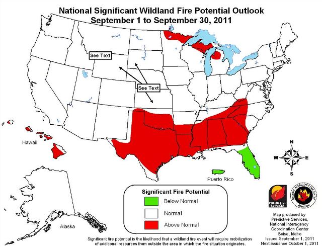
The Predictive Services section at the National Interagency Fire Center has issued their National Wildland Significant Fire Potential Outlook for September through December, 2011. If their prediction holds true, it looks like average or below average wildfire potential for most of the United States, except for Texas, Oklahoma, and the southeast.

Wildfire Outlook September 2011Wildfire Outlook October - December 2011