Meadow Fire — Yosemite National Park

(UPDATE at 8:55 a.m. PDT, September 10, 2014)

The spread of the Meadow Fire in Yosemite National Park in California has slowed, but still grew by about 100 acres on Tuesday to a total of 4,500 acres. As predicted, sunny weather and much lower relative humidity enabled some spot fires to become more active. There was also some isolated crowning and torching. On Wednesday the weather will be similar, but with stronger winds gusting up to 15 mph out of the west in the afternoon.

Firefighters are staying overnight in spike camps at several locations to reduce helicopter flights into the wilderness, but helicopters are being used to support crews with water drops. The highest priority is to secure the west flank to allow the trail to Half Dome to open.

The National Park Service has settled the issue of the origin of this fire, writing on InciWeb that it was an expansion of the fire that had been monitored since July 19, exacerbated by a wind event, rather than it being a new fire that started on Sunday.

Professional photographer Michael Frye posted some excellent photos of the fire on his web site.

****

(UPDATE at 8:35 a.m. PDT, September 9, 2014)

3-D Map of the Meadow Fire
3-D Map of the Meadow Fire at 11 p.m. September 8, 2014. Looking east. Half Dome can be seen in the center of the image, between Yosemite Valley and the fire. (Click to enlarge.)

The Meadow Fire in Yosemite National Park has grown to about 4,400 acres and was still very active when it was mapped Monday night. Rain showers passed through the area Monday morning but the precipitation may have evaporated before much of it hit the ground, since a weather station in Yosemite Valley did not detect any rain. Another weather station about 12 miles northwest of the fire measured 0.07 inches.

The Meadow Fire was first reported on July 19 but was not suppressed. It had spread to cover 19 acres while it was being monitored, until Sunday, September 7 when it began to grow rapidly pushed by a very strong wind.

On Sunday 85 hikers and climbers were evacuated from the summit of Half Dome by helicopters from the California Highway Patrol, U.S. Forest Service, Sequoia & Kings Canyon National Parks, and CAL FIRE.

High humidities assisted firefighters on Monday, slowing the spread of the fire, but the RH will lower into the 20s on Tuesday and no rain, in fact no clouds, are in the forecast for several days.

Cooper’s Type 2 Incident Management Team assumed command of the fire Monday. No information about the fire has been posted on InciWeb, however we found some updates on Facebook and the park’s website.

Map of the Meadow Fire at 11 p.m. September 8, 2014
Map of the Meadow Fire at 11 p.m. September 8, 2014. North is up. (Click to enlarge.)
 Meadow Fire
Half Dome reaches above the smoke created by the Meadow Fire, as seen from Sentinel Dome at 8:51 a.m. PDT, 9-9-2014.

****

(UPDATE at 5:11 p.m. PDT September 8, 2014)

The NPS announced Monday morning that the fire in Yosemite has been mapped at 2,582 acres, up from the 700 acres reported late Sunday.

This time-lapse video of the fire is fascinating. It gets better at 0:21 after the camera is moved out of the bottom of the valley.

Continue reading “Meadow Fire — Yosemite National Park”

Two fires in Yosemite; one threatens structures

(UPDATED at 8:50 a.m. PDT, July 31, 2014)

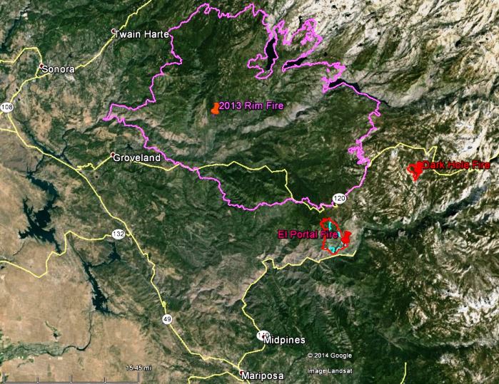
Map of the El Portal and Dark Hole Fires
Map of the El Portal and Dark Hole Fires, 11:45 p.m., July 30, 2014 (click to enlarge)

The map above shows the perimeters, in red, of the El Portal and Dark Hole Fires in Yosemite National Park. The blue line was the perimeter of the El Portal fire about 48 hours earlier. The 2013 Rim Fire can be seen north of those two fires.

The El Portal Fire added another 300 acres on Wednesday when it ran for over half a mile in the Crane Creek area, bringing the total to 4,200 acres.

There was rain on the Dark Hole fire on Wednesday, allowing only an additional 11 acres of growth.

Approximately 1,063 personnel are assigned to the fire.

As of Wednesday night, the Big Oak Flat Road (Highway 120) in Yosemite National Park has been reopened to vehicular traffic. The road was temporarily closed due to fire activity related to the El Portal Fire. All other roads within the park, including the Tioga Road, are open and clear, with the exception of the Foresta community access road, which remains closed. Crane Flat, Yosemite Creek, and Bridalveil Creek Campgrounds remain closed. All other park campgrounds are open.

****

(UPDATED at 7:10 a.m. PDT, July 30, 2014)

The El Portal Fire outside the entrance to Yosemite Valley in Yosemite National Park has burned about 3,545 acres and the incident management team is calling it 34 percent contained. Over the last 24 hours the fire was very active on the north side.

Big Oak Flat Road is still closed and the community of Foresta remains under an evacuation notice. The fire is threatening the Merced Grove of Giant Sequoias in the park.

Continue reading “Two fires in Yosemite; one threatens structures”

Time lapse video, Yosemite National Park

To see a much larger image, click the full screen icon at bottom-right.

This video is a collaboration between Sheldon Neill and Colin Delehanty. All timelapses were shot on the Canon 5D Mark II with a variety of Canon L and Zeiss CP.2 Lenses.

You are welcome.

And here’s the sequel:

A 200+ mile backpacking experience through Yosemite National Park captured by Colin Delehanty and Sheldon Neill. This project was filmed over the course of 10 months. They spent a combined 45 days in the park capturing the images in this video.

Virtual tour of the Rim Fire area

This is an excellent virtual tour video that shows the geographical relationship of the 187,000-acre Rim Fire to Yosemite National Park, Yosemite Valley, and some of the other landmarks in the area.

Our main article about the Rim Fire is updated daily with maps and current information.

California: Rim Fire at Yosemite NP

(UPDATE at 9:45 a.m. PDT, September 10, 2012)

Horseshoe Meadows Hotshots Rim Fire
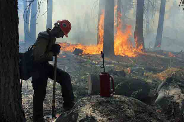
A crewmember of the Horseshoe Meadows Hotshots, on the Rim Fire, September 2, 2013. USFS Photo by Mike McMillan.

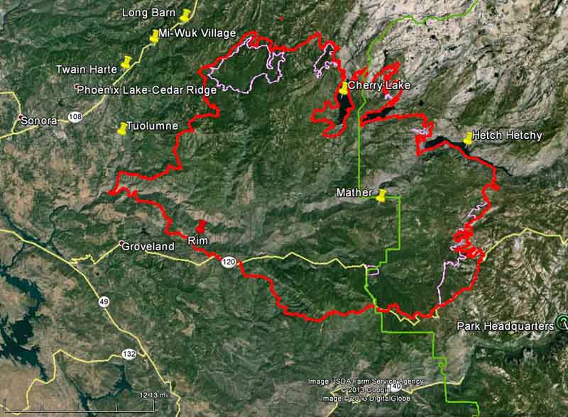
Firefighters have made some progress on the Rim Fire since our last update on September 4. As you can see in the map below, the fire has grown very little in the last six days, and most of the change in the fire perimeter is most likely a result of firefighters burning out the vegetation ahead of the fire.

Map of Rim Fire
Map of the Rim Fire. The red line was the perimeter at 1 a.m. PDT, September 10, 2013. The pink line was the perimeter at 9 p.m. PDT, September 3, 2013. The western boundary of Yosemite National Park is shown in green. (click to enlarge)

The fire has burned 254,685 acres and the incident commander is calling it 80 percent contained. Over 3,000 personnel are assigned to the incident, down from more than 5,000 a week or so ago. Over the last 24 days since it started, the costs for suppressing the fire has grown to $100.4 million.

****

(UPDATE at 6:50 a.m. PDT, September 4, 2013)

Rim Fire burnout
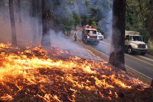
Rim Fire burnout, September 1, 2013. Photo by Mike McMillan.

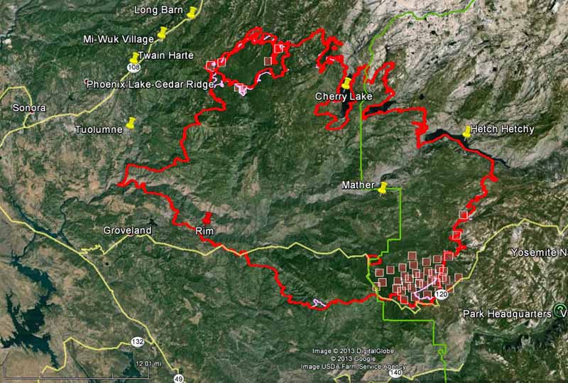
As shown in the map below, the spread of the Rim Fire has slowed considerably over the last several days. Most of the acreage increases are a result of burnout operations out ahead of the fire, sometimes miles from the fire’s edge, in order to remove the fuel, eventually stopping the spread. The west and southwest sides of the fire have been very quiet for a few days. The only significant movement of the fire which may not be related to burnouts are on the east side, with most of it being in the Cherry Lake area. On the southeast flank firefighters have selected Highway 120/Tioga Road as their fireline and are burning out along the north side.

The fire has burned 237,341 acres and the incident commander is calling it 80 percent contained. Another 3,000 acres and it becomes the third largest fire in California history.

Map of Rim Fire
Map of Rim Fire. The red line was the perimeter at 9 p.m. PDT, September 3, 2013. The pink line was the perimeter about 48 hours before. The red squares represent heat detected by a satellite at 10:40 p.m. PDT September 3, 2013. The boundary of Yosemite National Park is shown in green. (click to enlarge)

The strategy and tactics employed by the firefighters appear to be working. Instead of choosing the NEXT ridge for a fireline or burnout, they are selecting the BEST ridge, or sometimes a road, as the place to make their stand. This gives them enough time to execute what can be a miles-long burnout operation, and allows them some flexibility to conduct it at a time when the weather is favorable. These tactics have been used successfully on some very large fires on the Los Padres National Forest, including the Whitewater-Baldy, Basin Complex, Indians, Iron Alps, and Zaca fires.

There are currently no mandatory or advisory evacuation orders effective in Mariposa County. The evacuation advisory has been lifted for Ponderosa Hills and areas east, along the south side of Highway 108 up to Pinecrest. Highway 120 at the Yosemite National Park boundary west to Buck Meadows remains under evacuation.

Briefing at Rim Fire
Briefing at Rim Fire, September 2, 2013. Photo by Mike McMillan.


Continue reading “California: Rim Fire at Yosemite NP”