Smoke from Happy Camp Complex continues to plague residents of northwest California

Smoke from Happy Camp Complex continues to plague residents of northwest California

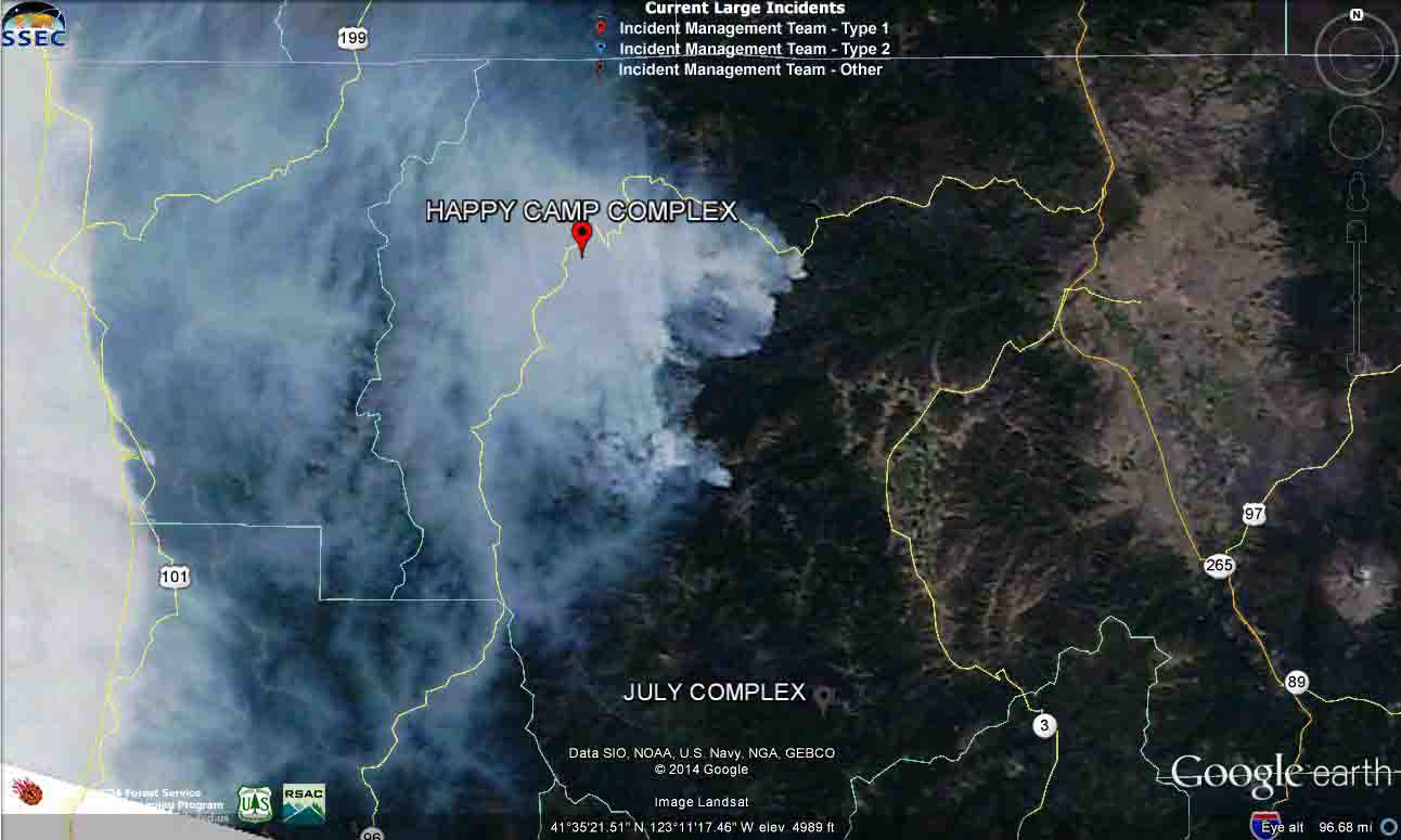
Smoke from the Happy Camp Complex of fires
Smoke from the Happy Camp Complex of fires in northwest California as seen from a satellite, September 5, 2014. The Smog Blog.

The Happy Camp Complex of fires in northwest California continued to expand on Friday, adding another 5,660 acres to bring the total up to 88,546 acres. The Incident Management Teams are calling it 25 percent contained. Another spot fire across the Klamath River and Highway 96 burned about two acres before it was knocked down north of the intersection of the highway and Scott River Road.

The Happy Camp area is infamous among wildland firefighters and locals for the inversions that trap smoke and keep it from dispersing. Some firefighters, after spending a couple of weeks in the polluted air, return home with respiratory problems that can linger for weeks or months.
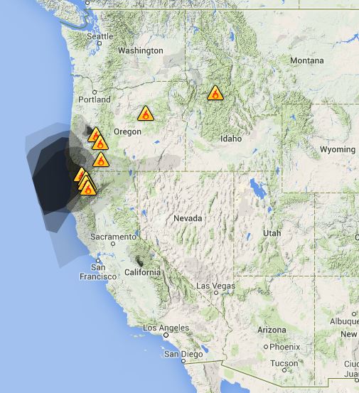
wildfire Smoke map, Sept 6, 2014
Smoke map, Sept 6, 2014. Weatherunderground.
Smoke map, September 5, 2014. for northern California
Smoke map, September 5, 2014. for northern California. Source: California Smoke Information.

The air quality agencies recognize the problem, of course, but there is little they can do about it other than inform the public about how bad it is. The chart below warns that during the three day period five communities had or will have “unhealthy” air to breathe for at least one day: Seiad Valley, Happy Camp, Somes Bar, Orleans, and Weitchpec. Two others, Hoopa and Willow Creek, were in the “Unhealthy for Sensitive Groups (USG)” category.
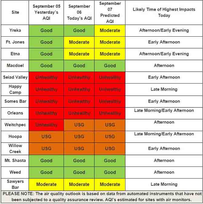
Air quality forecast for northern California
Air quality forecast for northern California. “USG” means “Unhealthy for Sensitive Groups”. Source: California Smoke Information.

The California Smoke Information website had more details about the wildfire smoke conditions, posted on September 6, 2014:

Yesterday — Winds pushed smoke to the Southwest which impacted the communities of the lower Klamath, Salmon, and Trinity River drainages. Smoke pooled into the valleys at night and kept smoke concentrations high. The forecast change in wind direction was delayed and has yet to occur.

Today — Smoke is predicted to travel southwest down the Klamath and Salmon River drainages in the morning hours. By afternoon, smoke will change directions and head eastward to the Scott and Shasta Valleys. Smoke will pool in valleys and drainages overnight.

Tomorrow — Weather will be similar to the previous day. Smoke is forecast to pool into valleys and drainages with low dispersion. Communities to the west of the fires may experience improved conditions as an onshore flow pushes the smoke slightly westward.

To see the most current smoke reports on Wildfire Today, visit the articles tagged “smoke” at https://wildfiretoday.com/tag/smoke/

Happy Camp Fire Complex closing in on “megafire” status

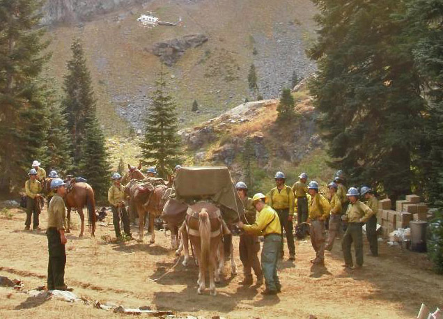
The Carson Hot Shots being resupplied by a mule team
The Carson Hot Shots being resupplied by pack animals on the Happy Camp Fire Complex. USFS photo by Mike McFadin.

The Happy Camp Complex of Fires west of Yreka, California is approaching what we have defined as “megafire” status — 100,000 acres of burned forest. As of Thursday night it has blackened 82,956 acres, a number that increases by 4,000 to 12,000 acres daily.

At a cost to date of $47.4 million, almost 3,000 people are assigned to the fire, along with 87 hand crews, 14 helicopters, 127 engines, 23 dozers, 43 water tenders, 29 mules, and 8 horses.

Some areas are still under an evacuation order.

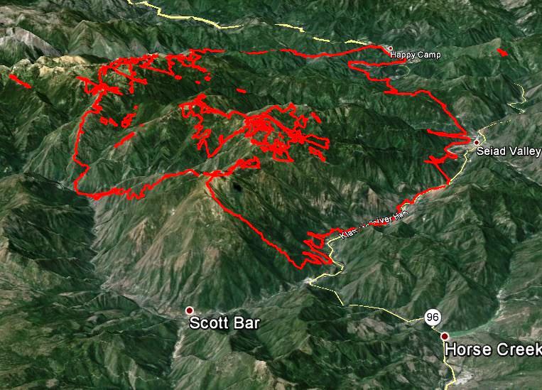
3-D Map of Happy Camp Fire
3-D map of the Happy Camp Complex Fire, looking west at 11 p.m. PDT, Sept 4, 2014.

Firefighters are hoping to keep the fire south of the Klamath River and Highway 96 between the communities of Happy Camp and Horse Creek, a goal they have mostly met, however there have been two large spot fires across the highway and the river that have been stopped. One of them was about 0.6 mile long and the other was about a tenth of a mile across.

On Thursday the fire was very active on the east side where it is burning downhill toward Scott River Road in the vicinity of Scott Bar (see the map of the fire above).

The area will remain under a Red Flag Warning through 11 p.m. Saturday due to a combination of strong winds and low relative humidity.

Lake Roosevelt area hit by strong winds, wildfire, and 7-foot waves

Lake Roosevelt storm
Effects of the windstorm at Lake Roosevelt National Recreation Area. NPS photo by Denise Bausch

The staff at Lake Roosevelt National Recreation Area on the Columbia River (map) in northeast Washington must have felt like they were in an apocalyptic movie on August 2 when the area suffered the wrath of a very strong wind event that triggered seven-foot waves, swamped boats, blown-down trees, and a lightning-caused fire. Here is how it was reported in the National Park Service’s Morning Report:

****

“On August 2nd, the third windstorm in as many weeks hit Lake Roosevelt, leading to numerous calls for help from boaters and causing significant damage and a wildland fire.

Staff from the park, the Colville Confederated Tribes and the Spokane Tribe of Indians responded to numerous calls of boaters in distress and property damage from wind gusts as high as 50 mph that created waves up to seven feet high. Miraculously, no one was injured or hurt inside the recreation area.

Boaters were plucked out of the lake and swamped vessels were de-watered. Numerous trees were blown down in campgrounds, damaging several travel trailers, and the park sustained thousands of dollars of damage to boat docks and anchor systems.

A lightning strike from the storm started a fire inside the park downstream of the Enterprise Boat-in Campground.  The Enterprise Fire was in steep and rough terrain.  Responding rangers did a GAR assessment to size up the fire safely.  A Type III incident [management] team was brought in to manage the multiagency effort, including NPS staff from Lake Roosevelt and North Cascades and personnel from the Forest Service, the Washington State Department of Natural Resources and the Stevens County Volunteer Fire Department.

Concentrated aerial operations and successful burnout efforts kept the fire from moving from a heavily timbered area into several homes and structures in the adjacent wildland/urban interface.

During aerial operations, a five-mile section of the Columbia River was closed by the superintendent and the U.S. Coast Guard utilizing the “captain of the port” authority. Park rangers utilized vessels to enforce this safety zone so fixed wing aircraft and helicopters could dip water for suppression activities.  They also transported firefighters across the water to and from the burned areas, and stayed close in case an evacuation was necessary.

[Submitted by Marty Huseman, Chief Ranger]

Unedited video of 2012 fire tornado in Australia

Firenado Australia- WILD vision from chris tangey on Vimeo.

In 2012 we posted a video of a fire tornado that was shot by Chris Tangey of Alice Springs Film and Television while he was scouting locations near Curtin Springs station in Australia. Mr. Tangey has produced another version of the video (above) after requests from many fire scientists and meteorologists worldwide who wanted an unedited version.

He explains:

As we approach 2 years since this extraordinary natural event was captured, here is the last version we will release online of the 40 minutes we recorded on September 11 2012. Unlike previous clips this is wild vision at actual speed, a totally unedited and uninterrupted 3 minute “chunk” of the event as it happened. Intended for Fire Scientists, Meteorologists and fire tornado “aficionados”, it allows a more continuous view of the physics behind local atmospheric conditions, and the actual behavior of the vortex of smoke and fire. Best viewed on a large screen with a home theater system, an important point is, regardless of the pictures, this is possibly the first ever time the awesome tornadic sound of a fire whirl has ever been professionally recorded in the wild.

Wildfire briefing, September 4, 2014

Kilauea lava flow in Hawaii emerges again from ground crack, continues advancing eastward, ignites forest

The following photos and videos were released by the Hawaiian Volcano Observatory (USGS) (Dated September 3, 2014 and September 1, 2014) .

Lava flow
This view looks east at the far end of the June 27th lava flow. In the center of the photograph is an isolated pad of lava which came out of ground crack last week. Further movement of lava within ground cracks has enabled the flow front to advance farther east, with lava issuing from a ground crack in the upper left portion of the photograph, where plumes of smoke mark the location of lava burning forest. (USGS)
Lava flow
One small portion of the flow front was quite vigorous, with an open stream of lava moving through the forest. (USGS)

More information about the lava flow.

Woman who bragged about setting fire, sentenced to prison

The woman who posted on Facebook about setting a fire was sentenced to more than a year in prison by U.S. District Court Judge Marco Hernandez on Wednesday. She was also ordered to perform 200 hours of community service in the fire-damaged area.

“You owe them much more than that,” Judge Hernandez told her.

Sadie Renee Johnson said she was suffering from alcohol and drug problems and told the judge she would turn her life around.

On July 22, 2013, two days after throwing a firecracker into vegetation to start a fire so her firefighter friends would not be “bored”, Ms. Johnson, 23, wrote on her Facebook page: “Like my fire?”

It grew to become the 51,480-acre Sunnyside Turnoff Fire on the Warm Springs Indian Reservation in Oregon, the 15th largest fire in the United States in 2013.

Ms. Johnson pleaded guilty on May 19 to the crime of setting brush and timber on fire.

Another insurance company offers homeowners proactive protection from ongoing fires

The Fireman’s Fund Insurance Company has expanded its wildfire program to include response services, which may include the application of gel or retardant solutions to a policyholder’s home and surrounding vegetation. The Wildfire Response Program, which already included wildfire assessments and extensive wildfire preparation for homes and land, now provides a complimentary additional layer of protection to eligible Prestige Home℠ policyholders who enroll.

During a wildfire, actions to defend a home may include:

  • Removal of combustible materials from around the home
  • Set-up of a perimeter sprinkler system
  • Spray the home or surrounding property with a fire-blocking solution.

The Wildfire Response Program is currently offered in the following states: Arizona, California, Colorado, Idaho, Montana, New Mexico, Nevada, Oregon, Texas, Utah, Washington, and Wyoming.

LA County brings on an Air-Crane and two scoopers

As they have done for the last 21 fire seasons, the Los Angeles County Fire Department has contracted for two water-scooping air tankers. The CL-415s, leased from the Quebec government, started at the first of this month and will be able to carry up to 1,620 gallons of water with each drop. Due to numerous fires late in 2013 and the Colby Fire in January, 2014, they worked several weeks beyond their planned December termination date last year.

The department also brought on a Helitanker, an Erickson Air-Crane S-64F that can hold 2,650 gallons of water or retardant.

More information and photos are at Fire Aviation.

Colorado’s multi-mission aircraft is in service

The state of Colorado has a temporary version of their multi-mission aircraft officially in service while the two they purchased are being outfitted and configured. It is being operated and maintained by Bode Aviation under contract to Sierra Nevada Corporation (SNC). Until the Division of Fire Prevention and Control (DFPC) personnel have completed their training, SNC will be providing qualified “Sensor Operators.

Today, for training purposes, the aircraft and crew are using its sensors to detect and map a prescribed fire near Gypsum, Colorado.

More information and a photo are at Fire Aviation.


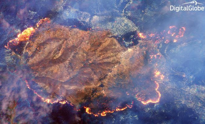
New satellite photographs Happy Camp Complex of fires

Digital Globe satellite view of Happy Camp Complex
Digital Globe satellite view of Happy Camp Complex of fires.

On August 13, 2014 a privately owned company launched another of their satellites to photograph the Earth’s surface. Digital Globe’s WorldView-3 satellite has advanced technology, a shortwave infrared (SWIR) sensor, that can see through the dense smoke of an active wildfire. The image above was collected from 383 miles above the ground during the last week of August while the Happy Camp Complex of fires in northwest California was spreading along most of its perimeter. At the Digital Globe website, there is a photo with a slider that compares the smoke-obscured visible spectrum imagery with the SWIR photo above. The difference is striking.

After they receive clearance from the U.S. Government, they will make available satellite imagery with a one-foot (30 cm) resolution, which is unprecedented outside of the government.

On their website, Digital Globe wrote:

We are looking forward to providing this new capability to firefighters and emergency responders around the globe as we help them to save lives and resources – yet another example of how DigitalGlobe fulfills its purpose of Seeing a Better World™.

 UPDATE: September 5, 2014:

We reached out to Digital Globe and asked how often WorldView-3 collects imagery from the same area, and found out that it has an average revisit time of less than one day, and can take up to two days.  The satellite provides 31 cm panchromatic resolution, 1.24 m multispectral resolution, and 3.7 m short-wave infrared resolution.