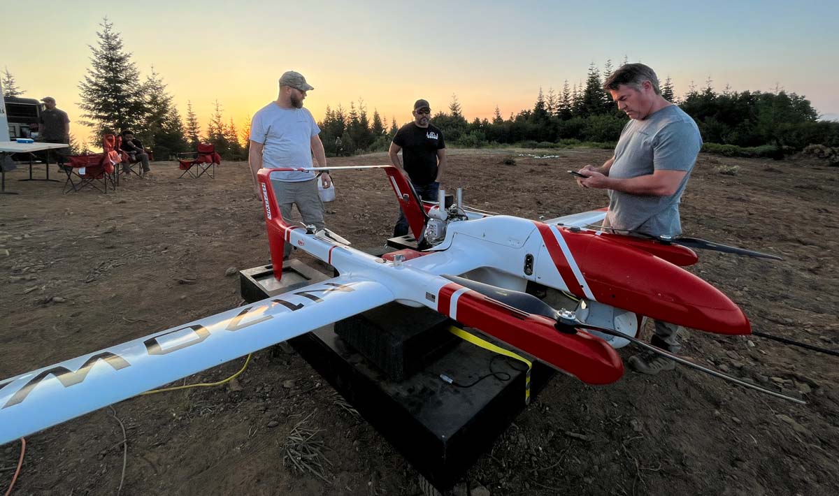
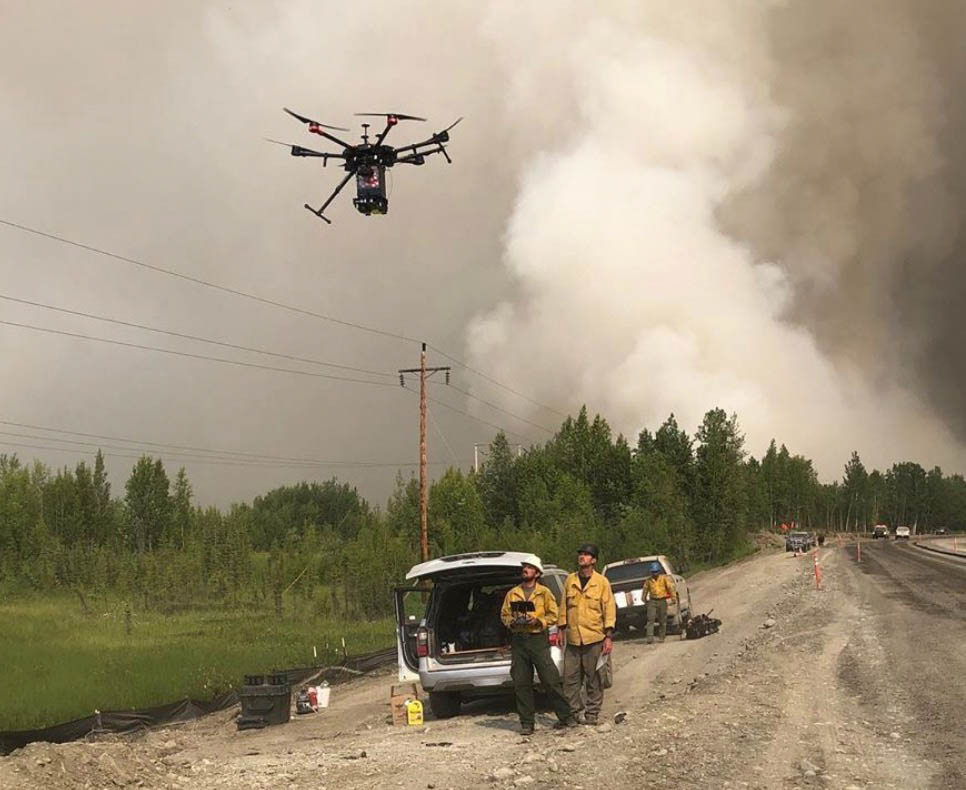
A contracted UAS crew with Precision Integrated Programs / Overwatch Aero — Tyler Kock, Daniel Rodriguez, and Cliff Savage — on the Lighting Complex of fires. US Forest Service photo by Andrew Avitt. FVR-90, N170WA.
By Andrew Avitt, US Forest Service, Pacific Southwest Region
Drones – also called UAS or unmanned aerial systems – are playing an increasingly important role in fighting wildfires by supporting operations with aerial ignition and gathering intelligence for firefighters. The greatest benefit drones provide is they can take to the sky when manned aircraft are grounded for pilot safety.
Take, for example the FVR-90, a fixed-wing drone with a 14-foot wingspan capable of traveling at speeds up to 46 mph with a flight time of 8 hours. They are sent airborne just at dusk when other manned flights are grounded. The sky is theirs, and the overhead view they have of the fire is detailed and in real time.
“The way we use UAS now is very much a supplement,” said Justin Baxter, the Forest Service National UAS Operations Specialist. “There are certain times that it’s just not safe for us to utilize manned helicopters or fixed-wing aircraft, like nighttime operations or in thick smoke or high winds.”
USFS photo by Andrew Avitt.
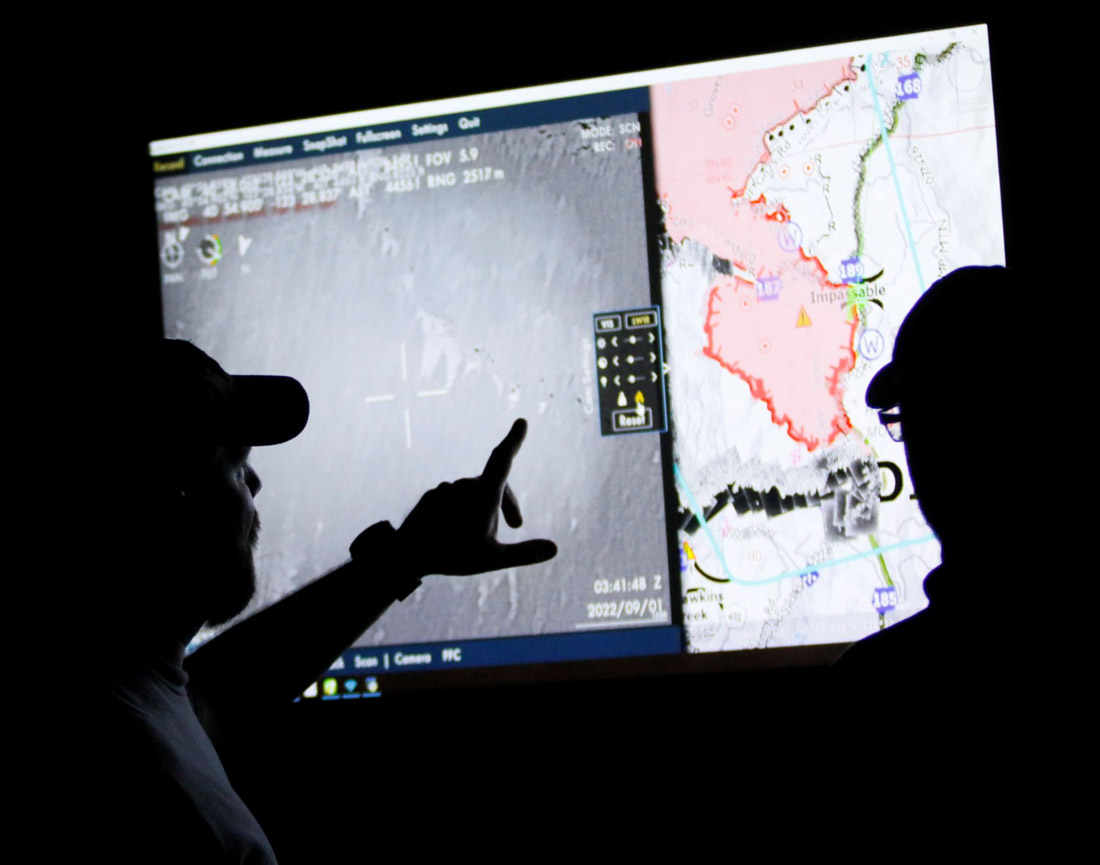
The drones that Baxter and his team fly are equipped with cameras that are not your normal cameras. They have multiple types of sensors, including infrared, that allow the team to see through smoke and, at night, see heat signatures, or thermal-based imaging. This allows the identification of areas where fire is still active and new areas where flames have advanced, such as spot fires.
Spot fires occur when embers from the main fire are thrown into the air and pushed by wind until they fall to the ground, starting a new fire. They are notoriously hard to identify because they are small at first and visibility is diminished by smoke. They may occur in hard-to-reach places difficult for firefighters to patrol, like on steep slopes or down in drainages.
“Drones are changing that labor-intensive process to identify these spot fires, especially when an operational area can span hundreds of thousands of acres,” Baxter said. With drones, fire managers and incident management teams can scan large areas quickly and easily identify spot fires that may be a mile from the main fire. That enables firefighters to get in and suppress those new starts before they grow.
“To give you an idea, this drone can detect a 2-inch by 2-inch spot fire from a half-mile away,” said Baxter as he gestured to the imposing drone just to his left minutes before takeoff to fly around the perimeter of the Six Rivers Lightning Complex Fire near Willow Creek, California.
Baxter said that much has changed since 2015 when the agency began the UAS program. With each passing year, incident management teams have increasingly incorporated the capability into their strategies.
The communication between the UAS crew and firefighters on the ground flows in both directions. The drone may be flying over and see heat in an area and transmit the information to a hotshot crew. Conversely, the hotshot crew can ask the UAS crew for assistance in exploring an area that they suspect might be active, and then view a feed from the drone of the area in question.
John Crotty served as the air operations branch director with California Interagency Incident Management Team 15 that responded to the Lightning Complex Fire on the Six Rivers National Forest.
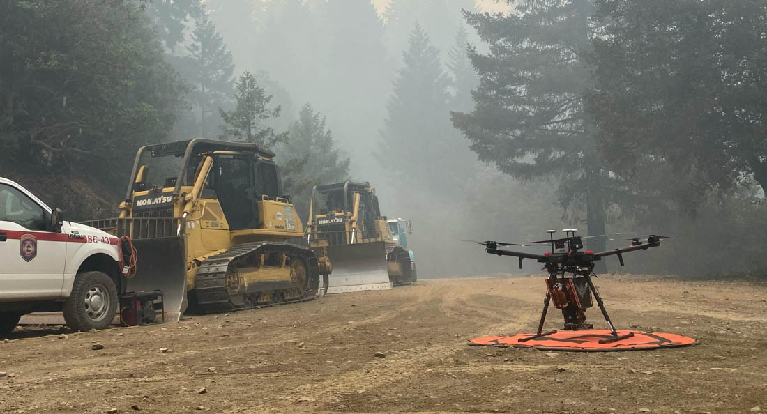
A drone equipped for aerial ignition. USFS photo by Mike Yearwood.
Aerial intelligence isn’t new in wildland firefighting, said Crotty referring to the recently retired Cobra helicopter and its Firewatch capabilities. But the implications of unmanned flight— that opens up new possibilities.
“With the Cobra aircraft, we needed a pilot and an interpreter up there to run the camera and talk to the folks on the ground. So, we expose two individuals plus a flight [to risk],” said Crotty, “But what we really needed was the visibility to fly.”
Thick smoke on the fires like the Lightning Complex can ground manned aircraft. That’s where drones come into play and the images it captures can inform firefighters working across a large area.
“The other day I heard from one of the hotshot crews out there. They were in heavy smoke conditions, at night. With the low visibility they couldn’t see if they had a spot fire across the line,” Crotty said. “This tool being up in the air, looking down at that exact area, the UAS crew was able to pinpoint the spot and provide precise coordinates to the firefighters who were able to check it out and put it out. That kind of information we would never have without these unmanned aircraft and that capability. Drones are the future of aviation for not only fire but for aviation in general. It’s a win-win for the agencies to operate under an umbrella of this type of aircraft that can provide precise and timely info to firefighters and incident management teams. And most importantly, we can do it safely.”
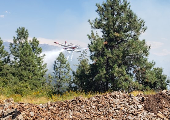
A single engine air tanker drops on the Moyie Fire August 21, 2022 near Moyie Springs, Idaho. Photo by Idaho Department of Lands.
Firefighters on the ground battling the Moyie Fire had to wait on aircraft support because a civilian drone was being flown in the area August 21 near Moyie Springs.
Aircraft ordered for the fire could not immediately fly because of the drone.
“The residents of approximately 50 homes in Moyie Springs were notified of the fire and the potential need for evacuation,” said Josh Harvey, Idaho Department of Lands Fire Bureau Chief. “Clearly, we needed to get air support for the firefighting effort as soon as possible and the drone put that on hold. Unfortunately this type of situation is not uncommon. We are reminding the public that drones can put firefighters, homes, and resources at risk.”
After the drone was gone, multiple firefighting aircraft went to work attacking the fire repeatedly while ground crews constructed a fire control line using hand tools. The fire was kept to three acres.
It is very dangerous to fly a civilian drone near a fire at which helicopters or fixed wing aircraft are operating. A collision could impact the windscreen or damage the engine, props, rotors, or flight control surfaces, causing a crash. If a drone is seen near a fire the standard operating procedure is to remove all aircraft from the fire area until it is confirmed that the drone has left the scene. In other words, it interferes with firefighting efforts.
It’s a federal crime punishable by up to 12 months in prison to interfere with firefighting efforts on public lands. Additionally, Congress has authorized the FAA to impose a civil penalty of up to $20,000 against any drone pilot who interferes with wildfire suppression, law enforcement, or emergency response operations. The FAA treats these violations seriously, and will immediately consider swift enforcement action for these offenses.
The US Forest Service is partnering with NASA to evaluate the use of two high-altitude long endurance drones to improve wildland firefighters’ situational awareness.
1. A balloon
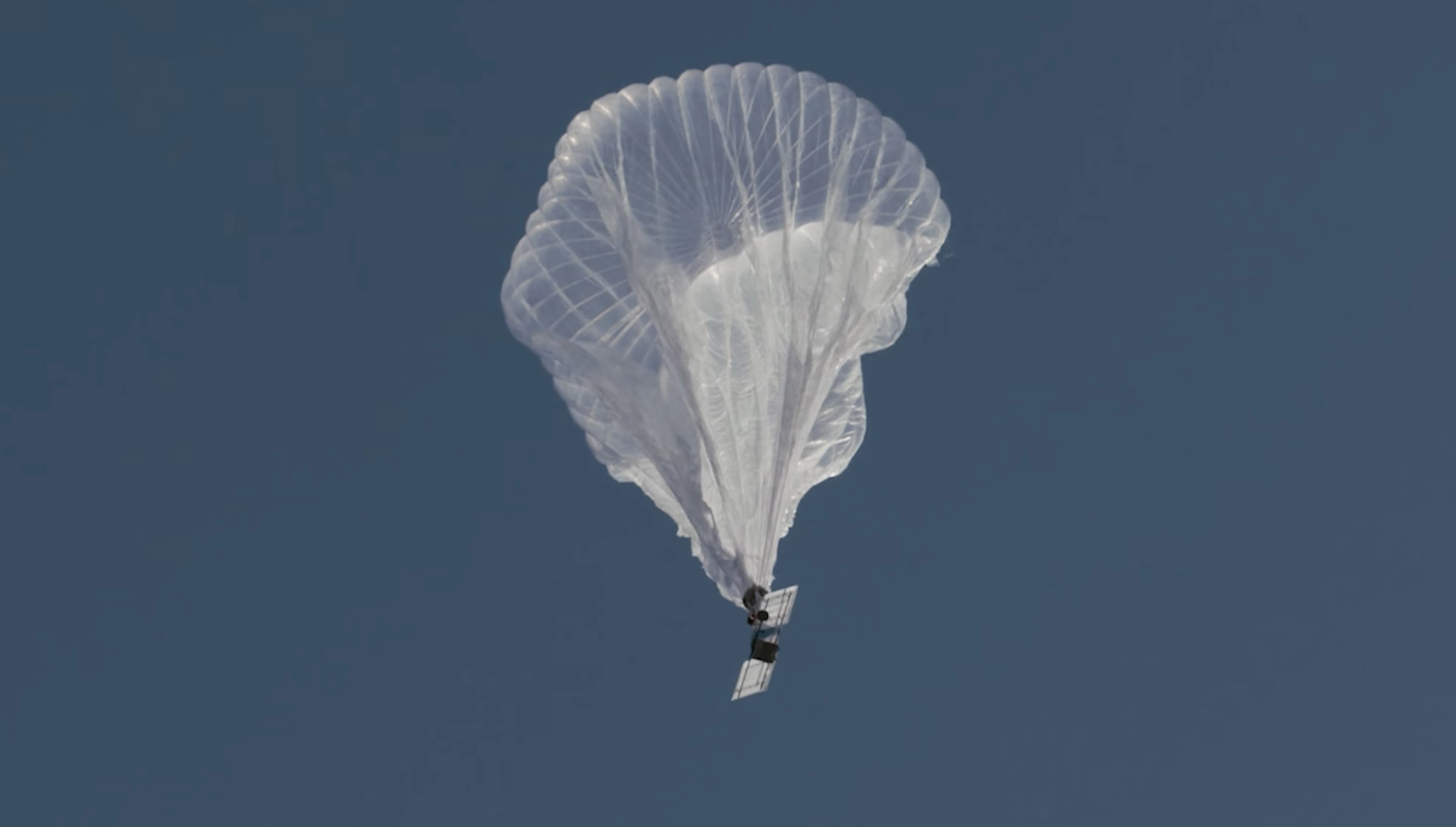
Last week a balloon laden with a sophisticated package of electronics hovered 60,000 feet over the Moose Fire in Idaho. Its mission was to assist firefighters in improving and maintaining situational awareness. Some of them may have seen the shiny object the size of a football stadium, even though it was more than 11 miles above the incident.
The company that built and operates the aircraft, Aerostar, calls it STRATO, or Strategic Radio and Tactical Overwatch, a technology that is in the research and development phase.
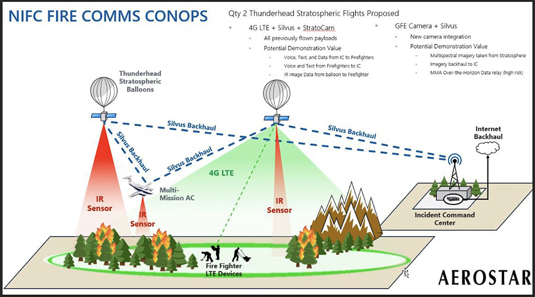
Illustration of how a Thunderhead Stratospheric balloon can assist wildland firefighters.
The STRATO is basically a giant mylar balloon with solar panels, batteries, radio equipment, cameras, and sensors. It has the capability to collect infrared and visual data, broadcast an LTE (cell phone) signal, has a high-band radio that can enable push to talk communications, and can operate a WiFi network. The huge helium balloon can hover over an incident in the stratosphere taking pictures, delivering data to incident managers, and providing communications options to the Incident Command Post and crews on the ground.
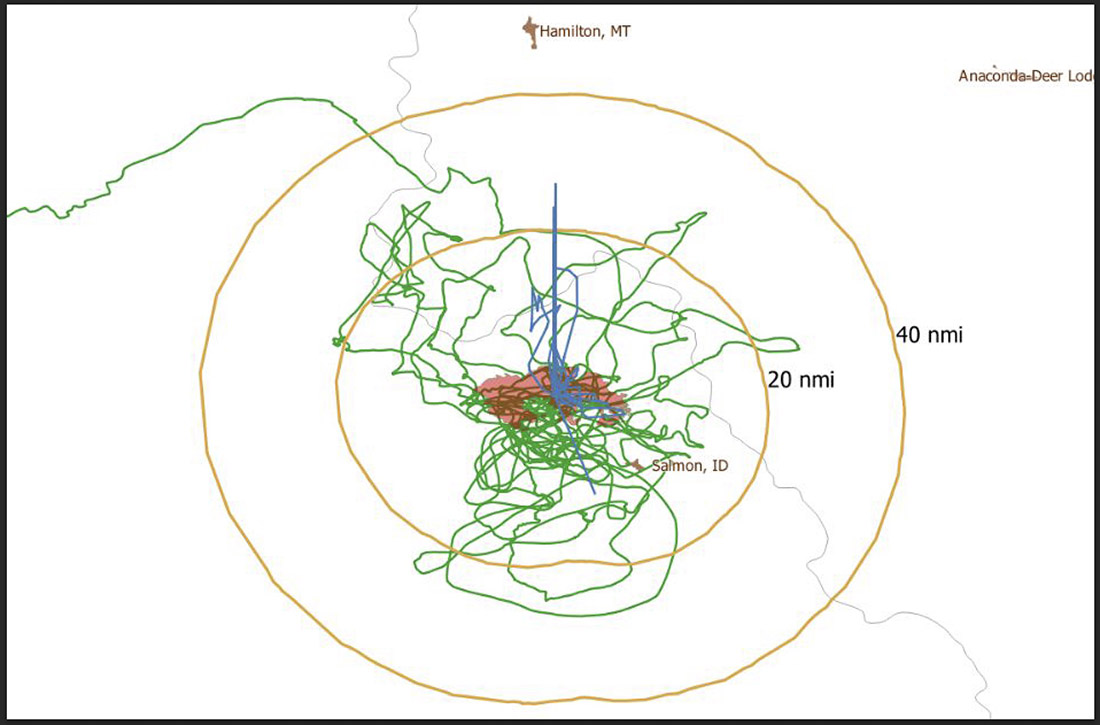
Flight path of an Aerostar Thunderhead Stratospheric balloon over the Moose Fire the week of August 7, 2022.
Last October Fire Aviation wrote about the system operated by Aerostar, a company based near Sioux Falls, South Dakota, which has been working with lighter than air technologies since 1956. We contacted the Communications Manager for the company, Lisa McElrath, who told us that in June, July, and August of 2021 they launched one of their Thunderhead Balloons from South Dakota and flew it west to monitor wildfires. While traveling more than 16,000 miles during its 70-day flight it engaged in station-seeking above four active fires for the company’s research and development. It collected visible and thermal imagery data for extended periods of time on the Robertson Draw Fire (Montana), the Dixie Fire (California), the Dixie-Jumbo Fire (Idaho), and the Dry Gulch/Lick Creek Fire (Washington).
In October we asked Ms. McElrath if Aerostar had been cooperating with the federal land management agencies in mapping fires. She said not yet, but that representatives from the National Interagency Fire Center had reached out to them and expressed interest in discussions after the fire season slowed down. But this year the US Forest Service is officially cooperating in the pilot project.
“We can provide real-time imagery from the balloon today in the visible and infrared,” Ms. McElrath said. “In the future, the goal would be to automate the detection and download of critical imagery, fire perimeters, likely fire-starts, and other key information via onboard processing so that more actionable information would be available. We see stratospheric balloon technology being the key to cost-effective, scalable wildfire surveillance that reduces time between new fire detection and response. Effectively, balloons can alert firefighters to a new fire while it is still small, before the fire grows into something newsworthy and very expensive.”
She said the balloons can also serve as radio repeaters for personnel on the ground and could collect information from tracking devices on firefighting resources which could then be displayed on a map.
More flights over fires are being planned, said Sean Triplett, Team Lead for Tools and Technology, U.S. Forest Service, Fire and Aviation Management. He said NASA is matching the funding the Forest Service is putting toward the flights this year.
2. Fixed wing aircraft
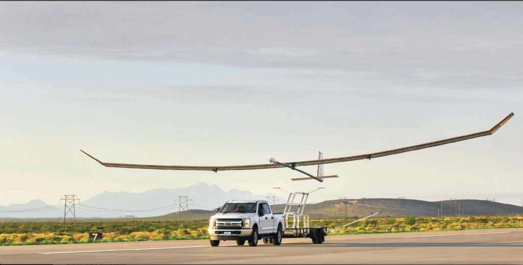
Swift Engineering’s SULE HALE-UAS. Swift Engineering photo.
Another High Altitude Long Endurance (HALE) aircraft the Forest Service is looking at is Swift Engineering’s SULE HALE-UAS, capable of staying aloft for more than 30 days at a time. The Forest Service, again partnering with NASA, has issued a contract with the company and as of March 31, 2021 they had conducted more than 10 demonstrations of the solar powered fixed wing aircraft.
The key to long duration flight using solar power on an airplane is to have a top surface area large enough for the solar cells needed to power the electric motors day and night, using a battery for night operations. Large wings mean more solar cells, but also more wind resistance. So the answer, using today’s technology, is to fly very high at 60,000 to 70,000 feet where the air is thin, the sunlight on the solar panels is strong, and there is less wind resistance.
The SULE, which took its first flight in July of 2020 has a 72-foot wingspan, operates at 70,000 feet, and can carry a payload of 15 to 22 pounds.
“A series of mid-altitude and high-altitude flights is being undertaken, Mr. Triplett told Fire Aviation on Wednesday. “At this point, the platform is only providing remote sensing products. However, if successful, additional systems may be incorporated.” Those added systems could include a radio system to provide connectivity enabling the tracking of firefighting resources on the ground in addition to live imagery of the fire.
Mr. Triplett said one advantage of having NASA as part of the project is that they can handle the airworthiness of the aircraft and interactions with the FAA.
The Swift Engineering video below shows what may be the first flight of the SULE two years ago.
A step toward the Holy Grail of Wildland Firefighter Safety?
Our view is that providing to wildland fire supervisors the real time location of both the fire and firefighting resources is the Holy Grail of Wildland Firefighting Safety. Lacking this information has led to at least two dozen firefighter fatalities. These High Altitude Long Endurance aircraft 13 miles above the fire could be an important link to transmit live video of the fire to personnel and provide radio connectivity enabling the tracking of firefighting resources on the ground even when they are in steep rugged topography. Of course the resources would need to have the hardware necessary to transmit the coordinates of their locations.
The John D. Dingell, Jr. Conservation, Management, and Recreation Act which became law March 12, 2019 required that by March 12, 2021 the five federal land management agencies “…develop consistent protocols and plans for the use on wildland fires of unmanned aircraft system technologies, including for the development of real-time maps of the location of wildland fires.”
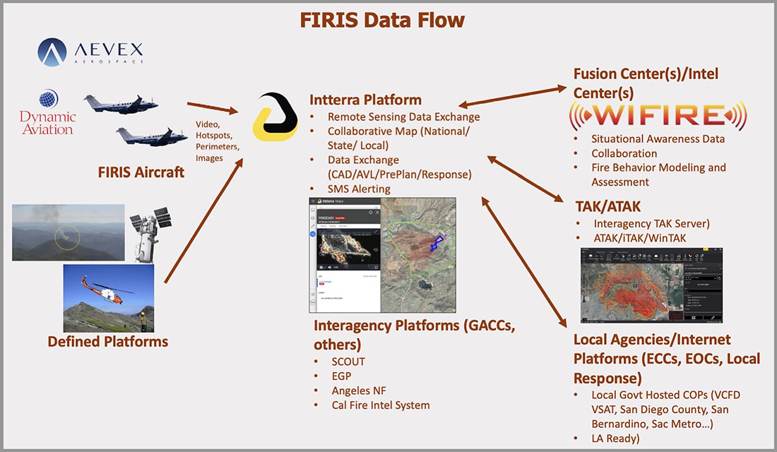
While this technology has been demonstrated, real time mapping appears to be far from being used routinely, at least within the Federal agencies. But at the state level, the Governor of California has requested $30 million in their next budget for 31 positions and funds for the state’s Office of Emergency Services to operate Real-Time Intelligence System (FIRIS) aircraft that have shown that they can provide real time fire mapping information. A pilot program for FIRIS first got off the ground September 1, 2019 thanks to funding secured in the 2019-2020 California state budget. This year two FIRIS ships have been assisting firefighters.
The Dingell Act also mandated that the five federal land management agencies “jointly develop and operate a tracking system to remotely locate the positions of fire resources for use by wildland firefighters, including, at a minimum, any fire resources assigned to Federal type 1 wildland fire incident management teams”, again, due by March 12, 2021.
Other solar powered high-altitude aircraft
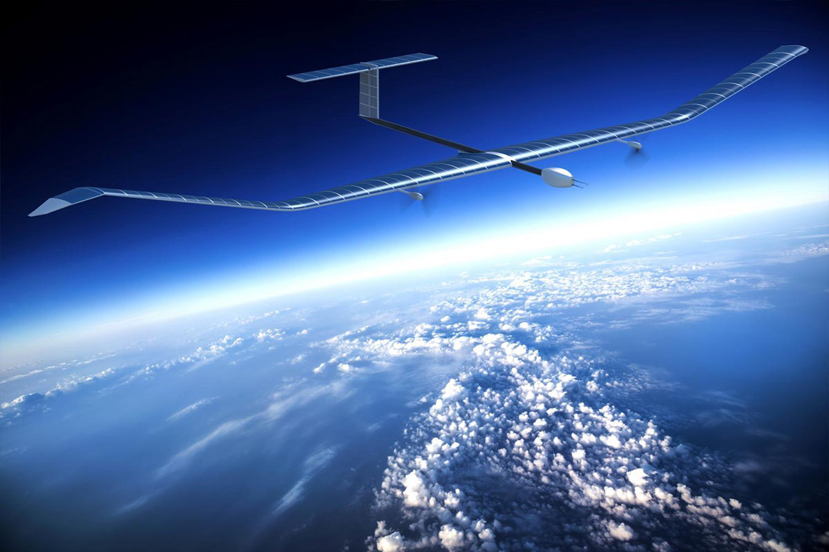
An aircraft that the Forest Service is not involved with is the Zephyr, made by AIRBUS. It is an unmanned, solar-powered fixed wing aircraft designed to stay aloft at high altitude for months.
AIRBUS Zephyr, stratospheric unmanned aerial vehicle. Airbus image.
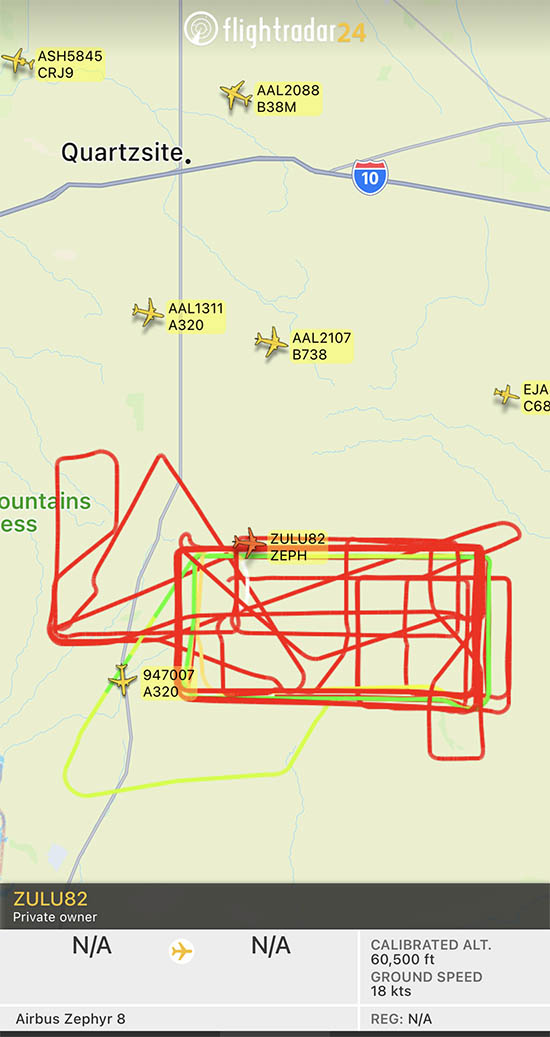
In its latest test flight that began June 15, 2022 the Zephyr took off from the U.S. Army’s Yuma, Arizona Proving Ground and has been flying patterns over the Yuma Test Range and Kofa National Wildlife Refuge ever since. Now 63 days later the flight has smashed Zephyr’s previous record of 25 days that it set in August 2018. When we checked August 17 it was cruising at 40 knots ground speed 70,500 feet above the Earth.
Flight path of ZULU82 Zephyr, a solar-powered unmanned aircraft on August 16, 2022, day 62 of a flight that began June 15, 2022.
UPDATE at 7:35 p.m. MDT August 21, 2022
The flight of the Zephyr has ended.
“Following 64 days of stratospheric flight and the completion of numerous mission objectives, Zephyr experienced circumstances that ended its current flight. No personal injury occurred,” AIRBUS said in a statement.
Simple Flying reported that a catastrophic loss of altitude occured on August 19 after flying for 64 days straight:
On its final day of operations, it was tracking around over the vast Arizona Desert, about halfway between Phoenix and Mexicali, Baja California. Flying slightly lower than was typical, at some 45,000 – 50,000 feet, it had completed an S-shape maneuver at around 50 – 60 knots when something went catastrophically wrong. ADSB data shows a vertical descent rate which rapidly increased, topping out at a speed of 4,544 feet per minute. Although unconfirmed by Airbus, it does seem that the Zephyr met a rather unglamorous end.
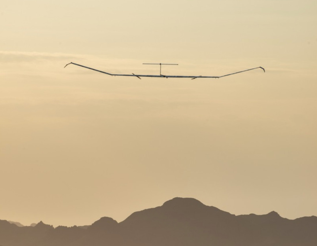
The Airbus Zephyr S during a 2021 test flight. US Army photo.
The Federal Bureau of Investigation is using a new system to help wildland firefighters by detecting, identifying, and neutralizing drones that are illegally interfering with firefighting activities.
It is very dangerous to fly a drone near a fire at which helicopters or fixed wing aircraft are operating. A collision could impact the windscreen or damage the engine, props, rotors, or flight control surfaces, causing a crash. If a drone is seen near a fire the standard operating procedure is to remove all aircraft from the fire area until it is confirmed that the drone has left the scene. In other words, it interferes with firefighting efforts.
The FBI is working with the Los Angeles County Fire Department to use a system that can detect a drone flying over a fire within 30 seconds of it being launched.
From CNN:
“When the detection equipment finds the drone and identifies the operator’s location, we can very rapidly get that information to a ground intercept team who can then go make contact with that drone operator and essentially get them to stop flying that drone,” said James Peaco III, the weapons of mass destruction coordinator for the FBI’s Los Angeles field office.
With a special sensor, the team can set up a boundary as large or as small as desired and get notified if a drone flies into that area, instantly obtaining precise details such as elevation, direction, speed as well as where the drone took off from and where the controller is currently standing.
“The first thing we do is order them to bring the drone back, explain to him that there’s a wildfire and flying that drone during a wildland fire is actually a federal felony,” Peaco said.
It’s a federal crime punishable by up to 12 months in prison to interfere with firefighting efforts on public lands. Additionally, Congress has authorized the FAA to impose a civil penalty of up to $20,000 against any drone pilot who interferes with wildfire suppression, law enforcement, or emergency response operations. The FAA treats these violations seriously, and will immediately consider swift enforcement action for these offenses.
According to the US Forest Service, in 2019 at least 20 documented instances of unauthorized drone flights over or near wildfires in seven states (Arizona, California, Colorado, Nevada, New Mexico, Utah, Washington and Minnesota) resulted in aerial firefighting operations being temporarily shut down nine times. There is no centralized national mechanism to report unauthorized UAS flights over wildfires, so these are only the incidents that wildfire management agencies have become aware of, there are likely more that are not known about.
Suspending air operations could decrease the effectiveness of wildfire suppression operations, allowing wildfires to grow larger, and in some cases, unduly threaten lives, property, and valuable natural and cultural resources. The effects of lost aircraft time could be compounded by flames moving into untreated terrain.
Thanks and a tip of the hat go out to Tom and Gerald.
Could allow for day and night water dropping and resupplying firefighters
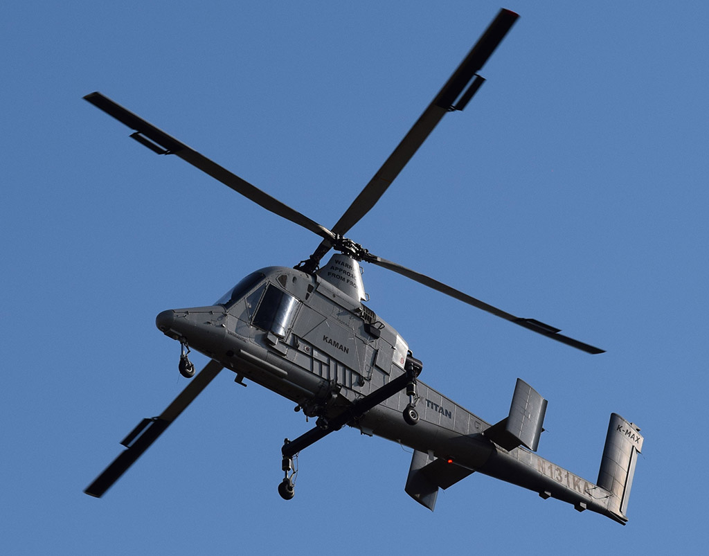
First flight of the Kaman TITAN Unmanned Aerial Vehicle helicopter. Kaman image.
Since Kaman designed, built, and flew in 1957 the first-ever unmanned helicopter, the company’s interest in unmanned aerial vehicles (UAVs) has carried over into the 21st century. This year the company introduced two more UAVs, a medium and a heavy lift helicopter.
Between 2001 and 2014 two Kaman K-MAX helicopters converted to UAVs capable of autonomous or remote controlled cargo delivery transported thousands of loads of supplies and equipment to soldiers in Afghanistan. They carried more than 1.5 million pounds of cargo, sometimes through areas that would be considered unacceptably risky for human pilots. Typically operating at night, these unmanned missions replaced the equivalent of 900 convoy vehicles and eliminated 46,000 hours of exposure time to IED’s, direct fire, and other threats to our troops on dangerous roads.
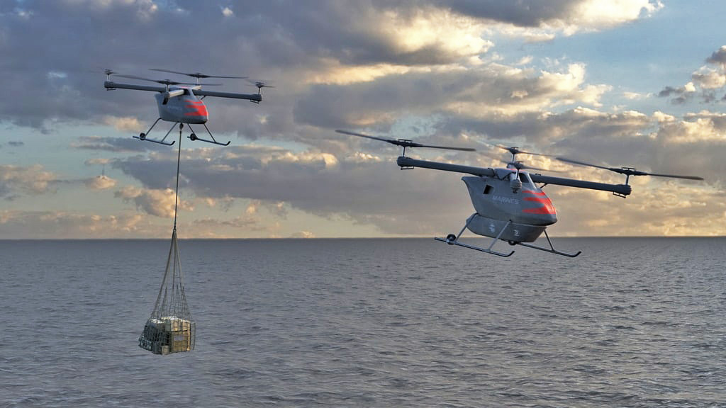
Concept for Kaman KARGO Unmanned Aerial Vehicle. Kaman image.
Kaman is making a new K-MAX TITAN system which will be available on new production K-MAX helicopters or to retrofit existing K-MAX ships. The system made its initial flight April 21, 2021 of what the company calls the world’s first heavy lift unmanned helicopter for the commercial market. The aircraft can lift up to 6,000 pounds which translates to about 700 gallons of water in an external bucket.
“Kaman leads the way with innovative solutions for our customers that are reliable, affordable and sustainable. K-MAX TITAN is no exception, whether the mission calls for firefighting, humanitarian assistance, or distributed logistics,” stated Darlene Smith, President, Air Vehicles and Precision Products Divisions.
Kaman also has a contract with the U.S. Marine Corps to upgrade the autonomous capabilities of their two USMC K-MAX helicopters.
The other Kaman UAV introduced this year is the KARGO UAV. Built with the U.S. Armed Forces future operating concepts in mind, the KARGO UAV offers a rugged design for easy transport and deployment. The system’s compact form-factor fits in a standard shipping container and is designed to be unloaded and operated by as few as two people.
“The Kaman KARGO UAV is the only system of its class that is purpose-built to provide deployed Marines, Sailors, Airmen, Soldiers, and Coast Guard autonomous resupply in the lethal, fluid combat environment that future military operations will entail or for regular logistics missions. Our deployed service men and woman have persistent logistics challenges that we are answering with this reliable, maintainable and affordable solution,” said Ian Walsh, CEO of Kaman Corporation.
The company says the vehicle also has multiple commercial applications.
Designed to provide cost-effective cargo hauling in its conformal pod or external sling load configuration, the KARGO UAV will self-deploy with no payload up to 602 miles with a maximum lifting capacity of 800 pounds. It should be able to haul approximately 90 gallons of water in an external bucket.
In September, 2021, flight development testing of a scaled KARGO UAV demonstrator was completed to prove out the air vehicle design, and flight-testing of a full-scale autonomous vehicle is planned for 2022. The KARGO UAV leverages commercial off-the-shelf components as well as thousands of hours of automated and autonomous flight data from Kaman’s K-MAX TITAN program, to reduce schedule and technical risk.
Kaman worked with Near Earth Autonomy as a partner to provide obstacle avoidance and other technologies such as precision landing, sense and avoid, and navigation in a GPS-denied environment.
In 2015 near Boise, Idaho Kaman and Lockheed demonstrated for wildland fire officials how a remotely piloted K-MAX UAV could drop water on a simulated fire and carry sling loads of cargo.
Our take:
We have written quite a bit recently about new UAVs, because there is a great deal of iteration and activity in the field. Some of the aircraft are already flying and others are still in the concept stage. Not all of them will take to the air or be used in a meaningful way. However, the interest in UAVs combined with limited numbers of firefighters, advances in technology, and increasing wildland fire acres produces an environment ripe for being exploited by nimble forward-thinking companies.
It appears likely that in the near future UAV helicopters will assist wildland firefighters not only by dropping water on fires but by resupplying them in remote areas with food, drinking water, hose, water tanks, and portable pumps — day or night. Already they are used for mapping, real time intelligence, and aerial ignition.
The limiting factor is government funding, and how quickly the old guard fire hierarchy can adapt their thinking to pilotless aircraft and flying at night.
The person who was awarded a patent in 2017 for describing a system of drones that could be used to drop liquids on wildfires wrote a paper earlier this year with two other authors that claims to have determined how many drones would be needed for suppressing a small section of a fire.
The patent, #WO2017208272A1, awarded to Marco Ghio, is quite vague and does not supply any technical details. It says that instead of applying fire retardant or water in a conventional manner, a “rain” concept would be used:
Dropping small quantities of firefighting liquid or drizzling it over the fire, and its subsequent spreading on a large area instead of in a concentrated manner. This method, both theoretically and experimentally, is acknowledged as being particularly effective, whereas, on a practical level, it is effectively used in domestic and/or industrial firefighting systems.
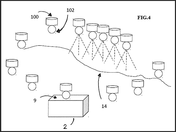
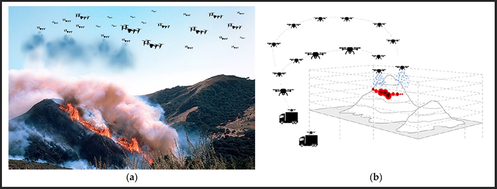
Figure 1. (a,b) Representations of the proposed firefighting system based on the use of a swarm of collaborative UAVs. (From the research)
In the United States fire retardant dropped from an approved air tanker is applied at coverage levels ranging from 1 to 9 gallons per 100 square feet, depending on the situation. It is not clear what coverage level “rain” would produce.
Drawing from the patent
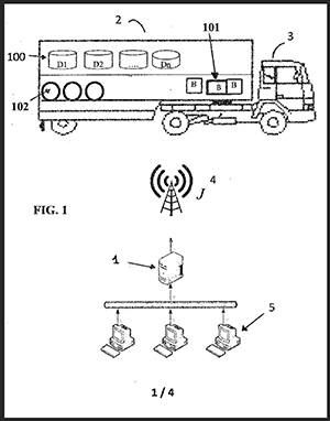
The patent specifies that drones would transport the liquid in removable containers. Upon returning empty to the mobile base the containers would be autonomously replaced with full containers, along with a charged battery if needed.
The drones and the other equipment would be transported in standard metal shipping containers which would be strategically positioned. The system would include “a control unit for the coordination of missions, the flight paths to be followed, and the selection of the ideal drop points optimized according to the environmental conditions.”
Details about how all of this would be accomplished are not specified.
The patent and the research paper written by Mr. Ghio, Elena Ausonio, and Patrizia Bagnerini assumes that the cargo capacity of the drones would be 5 to 50 liters (1 to 13 gallons), much less than currently carried by helicopters (up to 3,000 gallons) and fixed wing aircraft (up to 17,500 gallons) that routinely fight wildfires.
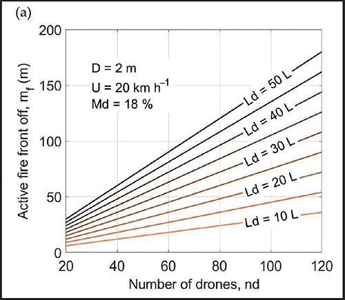
Their analysis (below) takes into account wind speed, flame length, the length of fire line to be suppressed, and the dead fuel moisture. It indicates that about 75 linear meters (246 feet) of the fire’s edge could be extinguished with 120 drones each carrying 20 liters (5 gallons) or 80 drones carrying 30 liters (8 gallons). The vegetation is assumed to be grass or brush, but not timber. The example below assumes that the wind speed is 20 km/hour (12 mph) and the dead fuel moisture is 18 percent. A moisture content of 18 percent for 1-hour and 10-hour time lag fuels is quite high for a very active wildfire. It should not be very difficult to suppress a fire under those fuel conditions.
Figure 4a shows the linear meters of fire that can be arrested by using the firefighting system. For example, approximately 70–75 linear meters of active front can be extinguished with 120 drones each carrying 20 L or with 80 drones carrying 30 L. Assumptions are that the wind speed is 20 km/hour and the dead fuel moisture is 18 percent. (from the research)
Our take
In my opinion the most difficult part of using drones to assist firefighters would be applying the retardant or water at the exact location where it can be useful. That is difficult enough when you have good communication with ground personnel, adequate aerial supervision, and experienced highly qualified air crews in helicopters or air tankers.
I don’t think the principle of “rain” in the application of retardant or water from dozens or hundreds of drones is a thing, at least when you’re talking about drones that can just carry a few gallons of water and must have the batteries replaced every 20 minutes. The suppressant still has to be delivered in a timely manner in a quantity and at the location where it can be useful. Maybe when drones are carrying 50 to 100 gallons of water, and the technology improves for placing the retardant on target, it might be useful in very remote areas when the fire is very small, less than 1/10 of an acre, and the wind speed does not exceed 5 mph.
Rain Industries is working on an Unmanned Aerial System (UAS) that could carry up to 400 pounds of cargo, or 50 gallons of water.
Drone Amplified, the developer of the IGNIS prescribed fire system currently being used for aerial ignition, and Parallel Flight Technologies, have received a $650,000 grant from the US Department of Agriculture to support further development of a large-scale Unmanned Aerial System (UAS) for prescribed fire. Parallel says their hybrid gas/electric UAS can carry 100 pounds for up to two hours, numbers that are much larger than battery operated drones. When paired with the upgraded aerial ignition payload under development which will hold and dispense 3,500 incendiary spheres, it will have eight times the payload carrying capacity of drones being used today, and ten times the flight duration.