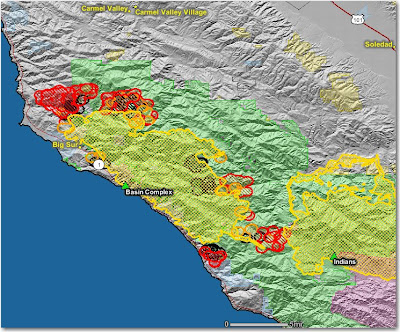
The Basin fire was very active yesterday due to the change in the weather.
East side-
Late yesterday the fire made a run north of Willow Springs campground, spreading over a mile to the north. It is now less than a mile from Tassajara. It was also very active at Lost Valley campground and west of Wildcat campground.
South side-
There was additional fire movement north of the Rodeo Flats trail where firefighters hope to tie in the fire to the Indians fire. The two fires are very close at this point. Slow progress continues on the Dolan ridge fireline; they have a couple of miles to go before the firing along this line reaches the coast highway.
North side-
Firefighters fired out at least 4 miles along Mescal Ridge between the Old Coast Road and east of Bottchers gap. They continued working on this overnight and may have completed much more. We hope they did, since the main fire is spreading rapidly towards the north.
The map below shows heat, in red, orange, and black, detected by satellites last night, with the red areas being the most recently burned. The yellow lines are the perimeters uploaded by the incident management teams yesterday. Click on the map to see a larger version.

