Two Sikorsky Aircranes over the La Brea fire. Photo: Doug Keeler
The fire grew by only 679 acres over the last 24 hours, which is much less than the 10,000 or so it was adding each day for a while. There is still some open line on the east and northeast sides, and firefighters are picking portions of the fire that have burned into the 2-year old Zaca fire area.
There are still a lot of resources assigned to the fire:
126 crews
56 dozers
12 helicopters
The fire has burned 87,490 acres and is 75% contained.
Lockheed fire
The fire has slowed, but it is certainly not out yet. Evan left a comment on another Wildfire Today post this afternoon, referring to smoke:
Wow. I can barely see 3 blocks ahead of myself in downtown Santa Cruz.
CalFire says the fire has burned 7,017 acres and it is 65% contained, and:
The Community of Swanton remains under a mandatory evacuation order. No evacuation orders for Bonny Doon. The evacuation order of the Bonny Doon community area was lifted at 3:00 PM on August 16, 2009. This allowed approximately 2200 residents to return home.
CalFire estimates full containment will be obtained on Thursday and it should be controlled by August 30.
Authorities now believe that the pilot who was flying the helicopter that crashed into the Fraser River in British Columbia on Friday is dead. Our sincere condolences to the family and co-workers.
Robert Christopher Woodhead, 53, of Stoney Creek, Ont., was operating a Bell 212 helicopter with a line and water bucket Friday afternoon when the aircraft went down in the Fraser River, near Lytton, B.C.
RCMP Cpl. Dan Moskaluk said Mounties believe Woodhead died soon after the chopper crashed in water 15 metres deep and with a swift current.
“We have met and spoken to the family,” Moskaluk said.
“It is believed that Mr. Woodhead perished in the river.”
Woodhead, who was based in B.C., was last seen in the water just after the crash by another pilot who was flying overhead.
That pilot tried to save Woodhead by lowering his own line and bucket into the water but the rescue attempt proved unsuccessful.
Moskaluk said search crews have recovered Woodhead’s flight helmet, as well as pieces of debris from his helicopter, but they have yet to find the man’s body in the water.
“In incidents of this nature, with the incertitude of the person’s fate, it leaves all in a suspended state of deep grief,” he said.
“Our thoughts, along with those of all British Columbians, whose lives and homes were protected in this and in past fire seasons by the courageous efforts of ground firefighters and the pilots assigned to battling these blazes, are with the Woodhead family at this time.”
There are two items of interest from our down under brothers and sisters.
Black Saturday report
A 360-page interim report from the Black Saturday bushfires royal commission was released on August 17. Here is an excerpt from The Australian:
THE Black Saturday bushfires royal commission has been scathingly critical of Victoria’s fire services and of Country Fire Authority chief Russell Rees, finding he failed to take on an operational role “even when the disastrous consequences of the fires began to emerge”.
In its 360-page interim report released yesterday, the royal commission found that public warnings issued by the CFA on February 7 were inadequate, its contentious “stay or go” policy understated the risk of dying while trying to defend homes and the control centre for the most serious Black Saturday wildfire was inadequately staffed.
The CFA and the Department of Sustainability and Environment’s fire agency, which were supposed to have a fully integrated command structure on Black Saturday, were in reality doing little more than sharing the same location on the day that 173 people died and more than 2000 homes were destroyed.
The royal commission has made 51 recommendations, including an immediate overhaul of the “stay or go” policy, better public warnings and the introduction of voluntary evacuations or “relocations”, and set a deadline for the Brumby government of September 30 to provide a schedule for implementing the changes.
Addressing concerns raised during commission hearings that its recommendations might not be fully followed, it has also demanded an update from the government by March 31 next year on how the implementation of the changes is progressing.
Premier John Brumby said yesterday all 51 recommendations would be accepted, although some only in principle until the details of what the changes involved were examined more closely.
$15 million for research related to the Black Saturday fires
The Bushfire Cooperative Research Centre will receive $15 million over three years tackle specific research tasks arising from the experience of the Victorian bushfires.
From a news release from Sanator the Hon Kim Carr:
“Following the devastating Victorian bushfires, there is an urgent need to address the outcomes of the Royal Commission. The Bushfire CRC is well placed to bring together university and public sector researchers with industry to collaborate on research and development projects associated with bushfires,” Senator Carr said.
Halle Safier at Cyclone Peak Lookout. Photo by Michael Gallacher
The Missoulian has an article about what it is like to staff the Cyclone Peak lookout tower in the Flathead National Forest in northern Montana. Here is an excerpt:
Cyclone Peak is aptly named.
On this bald, unprotected mountaintop four miles south of Polebridge, the wind whips and churns from all directions.
When it does, the peak’s high-rise fire lookout sways.
“When it’s really windy, I don’t go out on the catwalk,” explained Halle Safier, who is working this summer as a fire watcher for the first time. “You get used to it, and really, it’s kind of exciting when it really blows because it gets really loud in the lookout, the wind whistles in my stovepipe and the place comes alive.”
Safier’s summer home and office in the Cyclone Peak lookout tower is perhaps the most breathtaking place in the world to live and work.
Supported by a giant wood scaffolding, this postage-stamp-sized lookout some 50 feet above the ground takes 65 steps of ladder-like climbing to reach and offers what is truly a bird’s-eye view of Montana’s greatest treasure.
Safier sees it all from her unique vantage 6,000 feet above sea level as she conducts her primary lookout duties: collecting weather data, tracking lightning storms, and scanning the endless slopes and horizons for smoke and fire.
“I never get tired of looking at it,” Safier said. “I feel so fortunate to be able to live up here in this comfy little house in the sky.”
The wind, a visit from an occasional eagle, and daily radio conversations with Kalispell Dispatch and five other fire lookouts stationed nearby in the park, keep Safier company during her mostly solitary 10-day shifts.
A 12-volt radio, tuned to National Public Radio, allows her to keep pace with news of the world beyond the glass hut and its covered catwalk.
To fill the days when the fire danger is low, Safier attends to a long list of maintenance projects.
This season’s priority is digging post holes and building a tie rail for the mule teams that help bring in supplies at the start of the summer and when it is time to board up the lookout for the winter.
The place is in need of a fresh coat of paint, and so Safier is tackling that project as well.
In this relatively wet summer, there have been few fires to report.
“When we are busy with fire, we are really busy,” Safier said. “You are always on the radio, the cell phone is ringing, and you are always updating the coordinates. It can get a little wild.”
The U.S. Geological Survey on their web site has a virtual 360-degree tour of the view from Cyclone Peak Lookout. The photos were taken with infrared film in 1935.
Business is not exactly booming at the Billings, Montana air tanker base this summer. By this time last year they had pumped about 300,000 gallons of retardant. This year they have only pumped 14,000 gallons for six fires. The 10 employees there, after doing all the maintenance and weed whacking they could, have resorted to cribbage and reading.
Here is an excerpt from an article in the Billings Gazette:
In a business where speed, safety and adrenaline are as much a part of the mixture as water and fire retardant, slow days this summer at the Billings air tanker base seem unreasonably long to Bob Dobias.
“Even the few days we’ve flown it gets your adrenaline flowing and makes the time fly,” said Dobias, manager for Hunot Retardant. Hunot supplies the orange firefighting fluid to federal and state agencies for their aircraft at the east end of the Billings Logan International Airport.
As dark clouds build to the south, the base crew looks toward the gathering storm.
“The fire season isn’t over by a long shot,” said Jim Hassler, air tanker base manager for the Bureau of Land Management.
That’s a point he keeps reminding his crew of daily. That’s why they drill, watch videos and continually stress safety.
On Aug. 22 last year, the Dunn Mountain fire ignited in the Bull Mountains. By the time it was out, it had scorched 100,000 acres. That could easily happen again, any day, Hassler said. There’s plenty of tall grass nourished by a wet summer. Give it a few days of heat to dry out, and it makes prime tinder.
Fires like Dunn Mountain and the 10,200-acre Cascade fire west of Red Lodge kept the base hopping last summer. By this time last year, the base had pumped about 300,000 gallons of retardant.
If last season was a gusher, though, this season is a drip. So far, only a little more than 14,000 gallons have been pumped into aircraft on six fires. And last year was quieter than two earlier summers. In 2008, 490,000 gallons were pumped and in 2006, 1.25 million gallons.
I have been following the Primal Quest Badlands 2009, which is a six to 10-day 600 mile bike, run, hike, cave, climb, swim, and paddle race. This year the event is in the Black Hills and Badlands of South Dakota.
The route takes the 32 four-person coed teams through the Black Hills National Forest, Custer State Park, Wind Cave National Park, Angostura Reservoir, and Badlands National Park. The fastest teams will travel almost non-stop, day and night and will finish in about six days. Other teams will take as long as 10 days to complete the course.
It began on Friday with a marathon, just to get everyone warmed up.
The race attracts a wide variety of participants from all over the world. While the $11,500 per team entrance fee may scare away some, the teams come from as far away as New Zealand, Australia, Mexico, Spain, Ireland, Norway, the Netherlands, and Canada.
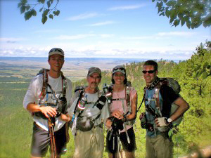
Team South Dakota: Eric Hansen, Gary Haven, Lisa Gustin, Andy Busse
I am pulling for the only team from South Dakota, called appropriately “Team South Dakota”. The four members of the team are, from left to right in the photo (and with links to each of their profiles):
Eric Hansen, firefighter with the Rapid City Fire Department
Gary Haven, Nurse Anesthetist
Lisa Gustin, Occupational Therapist
Andrew Busse, helicopter pilot for the South Dakota National Guard
You HAVE to be for a team that has a firefighter and a national guard helicopter pilot. Many (or all?) of the Blackhawk helicopter pilots for the SD National Guard are qualified to use a water bucket to drop water on wildfires, and they are used frequently on fires within the state. So with possibly 1/2 of the team having a connection to fire, it’s difficult not to be pulling for them.
Gary Haven was quoted in the Rapid City Journal:
“Since we don’t have any experience at this level, the goal from the beginning has been to just finish the course as a team,” said Haven, team captain. “If we do that, it would be considered a huge success.”
As this is written, they have moved up from 17th to 15th. In an international field of 32, that’s not bad for a team with no similar experience. Many of their competitors appear to have major corporate sponsorship, since some of the names include company names such as Subaru and Tecnu and other less familiar organizations.
The main web page for the race is HERE, and the leader board with the map is HERE. If you go to the main web page, a video with audio, over on the right side, annoyingly plays automatically. You can stop it by clicking the pause button.
One cool thing about this race is that you can follow the progress of all of the teams thanks to satellite technology. Each team carries a SPOT satellite transmitter, which updates their position every 10 minutes. You can see the map showing everyone’s location HERE.
Team South Dakota is team #36, so look for #36 when you view the map.
We have written about the SPOT devices before. In fact I know that the Laguna Hot Shots are on the east side of the La Brea fire right now by accessing their SPOT page.
There are several locations where the public can view the racers, including the campground in Wind Cave National Park, Angostura Reservoir, Crazy Horse, and Badlands National Park.