UPDATE @ 10:50 p.m., Sept. 7
The Boulder Office of Emergency Management, after surveying 5-10% of the burned area, has identified 53 houses that have been destroyed by the Fourmile fire. Due to the fire activity, they were not able to collect data in other areas.
ABC7 has information about the early stages of the fire, including transcripts from radio conversations and a report that a vehicle colliding with a propane tank may have started the fire.
At 8 p.m. the Rocky Mountain Area Coordination Center reported:
Type 1 Incident Management Team, Thomas in briefing at 1000 on 09/08. 6,128 acres. IR [fixed-wing Infrared] flight tonight to determine size. Counting of structures lost will begin tomorrow. 20 Subdivisions west of Boulder have been evacuated and 3 major county roads are closed. Fire is growing around the entire perimeter. Crowning, running, and spotting fire behavior has been observed.
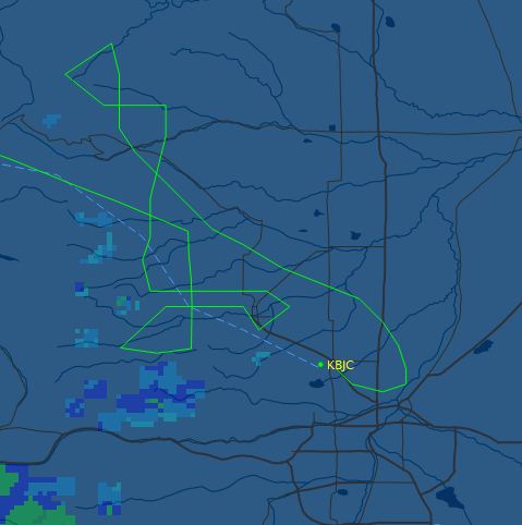
In fact, one of the US Forest Service infrared aircraft, a Super King Air 200 twin-turboprop, N149Z, has already flown over the Fourmile fire, and it looks like the Cow fire in Rocky Mountain National Park as well. The map below shows the aircraft’s flight path as it arrived into the area from Boise, flew over the two fires, possibly dodged some rain or thunderstorms, and landed at Rocky Mountain Metro Airport at 8:08 p.m. It has the capability to downlink the digital imagery wirelessly via Aircell while airborne. Then an Infrared Interpreter retrieves the files from a server, analyzes the data, produces a map showing the heat sources, draws an accurate fire perimeter, and calculates the acreage of the fire.
So, within a matter of hours we should have an accurate fire perimeter and acreage.
=========================================
UPDATE @ 6:15 p.m., Sept. 7
At a 4 p.m. press briefing today fire officials said that 7,100 acres had burned (later changed to 6,168 acres at the InciWeb site) and the fire had forced the evacuation of 3,000 residents. An inversion in the morning prevented air tankers from taking off, but later in the day eight air tankers had dropped 90,000 gallons of fire retardant by the time of the briefing. Three helicopters are also working on the fire. About 2,000 residences are without electricity in the fire area. With about half of the burned area being surveyed, they have identified 63 structures that have burned.
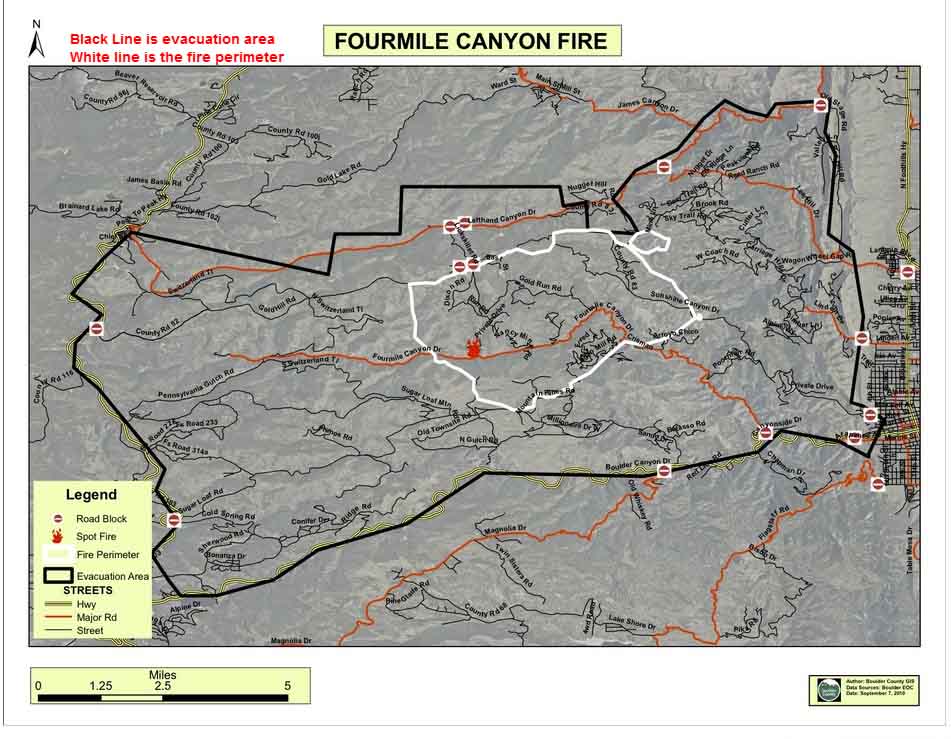
Here is a map produced today by Boulder County showing the perimeter and the evacuation area for the Fourmile fire. (We added the notes in red at the top.) The original higher resolution version of the map is HERE.
Click the map to enlarge it.
Another map of the fire perimeter can be found at the InciWeb site.
=============================================
UPDATE @ 5:00 p.m., Sept. 7
Here are some updated maps of the Fourmile fire near Boulder, Colorado.

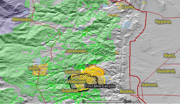
HERE is a link to a topographic map showing the fire perimeter as of noon today, but it is difficult to make out much detail.
================================================
UPDATE @ 12:20 p.m., Sept. 7
Five heavy air tankers were available at the Rocky Mountain Metro Airport as of this morning at 10:30.
Here is the “spot weather forecast” issued by the National Weather Service at 11:00 a.m. this morning specifically for the area of the Fourmile fire near Boulder:
REST OF TODAY
SKY/WEATHER………MOSTLY SUNNY.
MAX TEMPERATURE…..72-76.
MIN HUMIDITY……..9-13%.
20-FOOT WINDS…….UPSLOPE/UPVALLEY 6-12 MPH UNTIL 1500…THEN
SOUTHEAST 10-15 MPH.
TRANSPORT WINDS…..SOUTHWEST 12-20 MPH.
MIXING HEIGHT…….4000 FT AGL UNTIL 1400…THEN 7000 FT AGL.
AGL.
SMOKE DISPERSAL…..POOR UNTIL 1100…THEN GOOD UNTIL 1200…THEN
VERY GOOD UNTIL 1700…THEN GOOD.
HAINES INDEX……..4 LOW.
TONIGHT
SKY/WEATHER………PARTLY CLOUDY(40-50%).
MIN TEMPERATURE…..50.
MAX HUMIDITY……..45-55%.
20-FOOT WINDS…….SOUTHEAST WINDS AROUND 10 MPH UNTIL 2000…THEN
WEST 8-16 MPH WITH GUSTS TO 25 MPH ON THE RIDGES.
TRANSPORT WINDS…..SOUTHWEST 12-20 MPH.
MIXING HEIGHT…….6000 FT AGL UNTIL 1900…BELOW 1000 FT AGL
AFTER 2100.
SMOKE DISPERSAL…..FAIR UNTIL 1900. POOR AFTER 2100.
HAINES INDEX……..3 VERY LOW.
=================================================
UPDATE @ 9:42 a.m., Sept. 7
================================================
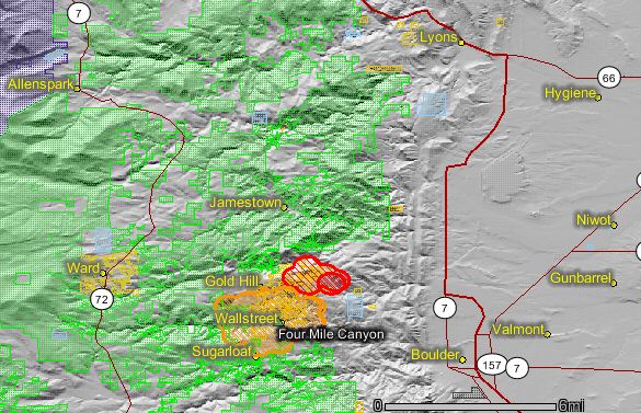
The Fourmile fire has burned at least 3,500 acres and destroyed dozens of homes northwest of Boulder, including the homes of four firefighters who were working on the fire. Some of the communities impacted by the fire include Four Mile Canyon, Sunshine Canyon, Gold Hill, Sugarloaf, Pinebrook Hills, and Boulder Heights. Approximately 3,500 residents are under mandatory evacuation orders.
The map of the Fourmile fire near Boulder shows that the fire has spread quite a bit towards the northeast compared to the map we published yesterday. On Monday the strong winds prevented aircraft from working on the fire until after 5:00 p.m. when the winds decreased and three were assigned, but on Tuesday morning four heavy air tankers, one lead plane, one large Type one helicopter, and two air attack ships will assist the ground-based firefighters, according to the Rocky Mountain Area Coordination Center.
A few hours after the fire started a Type 2 incident management team was ordered, but due to the size and complexity a higher-qualified Type 1 team was ordered last night. On Tuesday the one of the Rocky Mountain Area Type 2 teams will work with the Boulder County Type 3 team.
Cooler temperatures and winds speeds of 8-12 mph on Tuesday should produce less extreme fire behavior than we saw on Monday.
For official information about evacuations, visit the Boulder Office of Emergency Management web site.
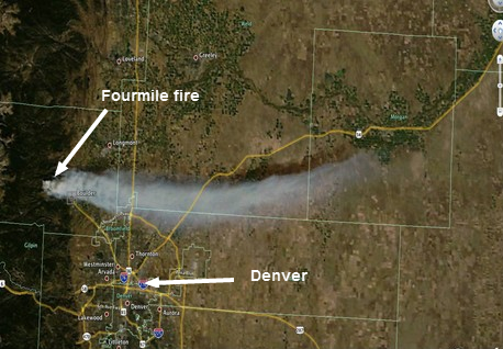
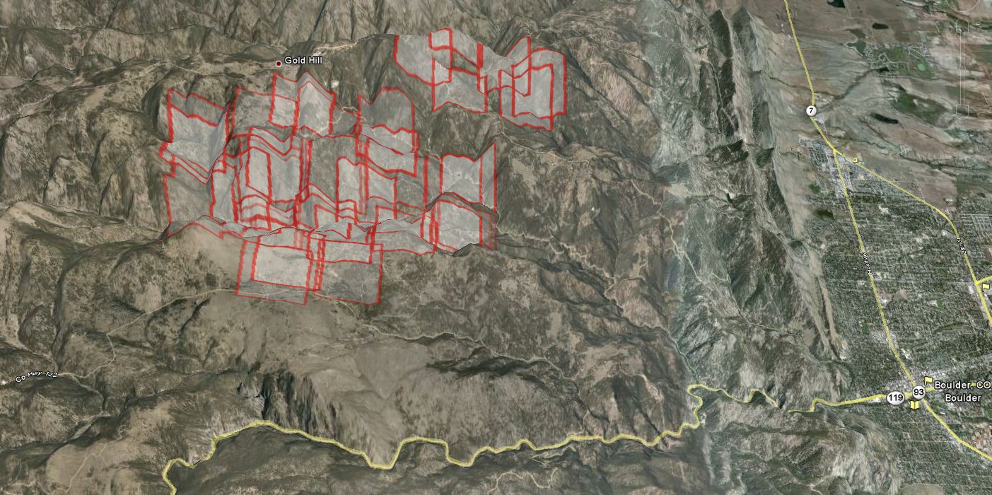
Here is a 3-D map of the Fourmile fire showing heat detected by satellites. Click on the map to see a larger version.
We will update this article throughout the day. Check back for more information.

Do you know if the measurement of the burn area is done with only 2-dimensional information? If it is then it would under estimate the burn area. Thanks.
MathP-
As far as I know all conventional measurements of land area are calculated in two-dimensions; at least all fires are. It’s an interesting question, though.
I use MatLab for my simulations and you would be able to do this calculation using it if you had the mapping toolkit. I would be able to do the calculation if they had out the perimeter coordinates somewhere, but I couldn’t find it. Also, nice MODIS images. Thanks for all the info.
Land is only measured in two dimensions. An acre with a hill in the middle has more surface area than a flat acre but the 2-D area is the same.
Anyone know anything about Sunshine Canyon, I haven’t heard from my friend that lives there. Thanks.
Kat, boulderoem.com has a partial list of homes destroyed, including Sunshine Canyon addresses, which start around the 5000 and up addresses. Hope your friend is okay.
List of houses lost is here:
http://www.bouldercounty.org/newsroom/templates/bocodefault.aspx?articleid=2304&zoneid=1
This site is the most accurate I have seen. I took an old access road to bypass the road block on Sugarloaf and drove to my house on Mountain Meadows. The entire road is still good including wild tiger.. But the fire is really pushing south over arkansas mnt. There were few houses in lower Sugarloaf that were still at home with power with the lights on. The firefighter I talked to said they were not going to let it come over and are putting everything on the line. I love those guys.
We live across the street from the eastern evacuation perimeter (near Mt. Sanitas). I haven’t been able to find any information on the direction the fire is going. Does anybody know? Media reports haven’t been helpful. Thanks for the information here.
Anybody have an idea of the area by ALDER LANE? From the map it appears OK, but still I am 1000 miles away and my parents perm. residence is there. They are even further away than me at the moment though. Thanks and God Bless all of you!
From the earlier topo map I saw with burn zone the townsite of Sunset is probably safe but hard to say. Mostly damage from Wallstreet northeast toward Boulder Heights/Pinebrook hills.
Just spoke with a firefighter taking a breather from the battle. This is still an unpredictable wildfire depending on wind direction and the slim hope of rain.
Does anyone have any info about the area where Switzerland Trail meets Four Mile Canyon Road?
Can you give me some information on Pinebrook Hills? From what I can decipher from the map, the fire is only a couple of miles from the N. Cedarbrook/Fountaintree area?
My sister and her husband who are out of town presently live on Arroyo Chico road. Does anybody know if the houses there have been affected?
Seems like the thermal imaging isn’t showing anything over there, and I haven’t heard anything about that particular area on the radio transmissions. I’d guess it’s currently unaffected.
I’ve also heard the Arroyo Chico is fine but right on the border line.
can you please post an updated map when one becomes available (ie tues afternoon/eve). Thanks!
Done. Thanks Clare, for visiting Wildfire Today.
Becki-
The map only shows on a very coarse scale areas where heat was detected by a satellite orbiting hundreds of miles above the earth. The areas identified on the map did not necessarily even burn, or if so, 100% of the areas marked may not have burned. So it is not possible, by looking at the map, to tell exactly what burned or did not burn.
I hope your house came out OK.
We live right at the west boundary of the heat images shown by mod is …about 1 mile west of Emerson gulch on fourmile canyon dr…does this map reflect areas that were in flames?
Thanks miked – I hope you’re right.
Betsy – I’ve heard mixed reports but it sounds like Gold Hill Inn wasn’t affected, so I’d have high hopes for houses along main street. You’ll probably get the most up to date information by listening to the Boulder Sheriff & Fire transmissions.
http://www.radioreference.com/apps/audio/?feedId=591
Thanks for checking. Hope you’re right.
Has the fire destroyed homes on main street in Gold Hill? I’m trying to get info. for someone who lives there.
This morning I was talking to a deputy at the store and he thought Gold Hill is pretty much gone. Of course he’s not a fireman so might not be a first hand account. Somebody else said Wallstreet is also gone!
I just saw pictures from someone who just returned from Gold Hill 2 hours ago and the actual old townsite and main street are fine. There are many houses around it affected though.
Boulder Canyon Dr is probably not going to be directly affected. The canyon is steep so the fire probably won’t get down there. It was closed last night, but rumors are that it’s open again today.
Winds are much calmer than yesterday but weather forecasts predict they will blow to the south soon (tomorrow; <18mph by most estimates). Given the topography of this area and its landcover, can anyone give some ballpark figures on the probability that the fire would reach Boulder Canyon Drive (i.e., CO-119)?