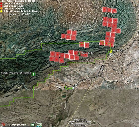
Update at 4:00 p.m. MT, June 14, 2011:
The New Mexico Fire Information web site has a notice about the Loop fire saying “White City” has been evacuated. I think they mean “Whites City”, which is just outside Carlsbad Caverns National Park. Highway 62/180 has been closed from Dark Canyon to the state line. The National Park is closed.
Carlsbad Caverns National Park Superintendent John Benjamin said:
Safety is a main concern. Once we are certain the park infrastructure is undamaged and it’s safe for visitors and staff to return, we’ll re-open the park.
Crews are conducting burnout operations along Highway 62/180 between Dark Canyon Road and Whites City in an attempt to keep the fire west of the highway.
The size of the Loop fire has been updated to 16,000 acres. It is 10% contained.
===============================

Another major wildfire is burning in the Southwest, this time in Carlsbad Caverns National Park in southern New Mexico. The fire started Monday at 2:15 p.m. and at the last report has burned 14,432 acres, much of it within the boundaries of the National Park.
From InciWeb:
The Pecos Zone Type III Incident Management Team (Tudor IC) took over management of the fire at 10 p.m. on June 13th from the local Type 4 organization. The Incident Command Post (ICP) is located at the Permian Basin Regional Training Center in Carlsbad, NM.
Special Notices: Carlsbad Caverns National Park has been CLOSED until further notice due to extreme fire activity and concern for public safety. All hikers and cave researchers known to be in the back country are all IN and ACCOUNTED for.
Summary: The fire is burning in steep and rugged terrain along State Highway 7 going into Carlsbad Caverns National Park off of US Highway 62/180. Crews are working aggressively to secure the fire perimeter by conducting burn out operations on different section of the fire but specifically around the community of White City, NM. The objective tonight is to keep the fire south of Dark Canyon Road and west of US Highway 62/180.
Map of large fires in the United States.
Below is a map showing heat on the Loop fire, detected by satellites.


