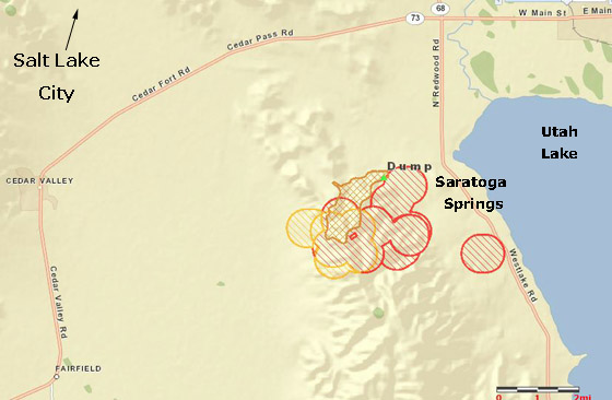
UPDATE at 5:49 p.m. MT, June 22, 2012
A type 2 Incident Management Team, Great Basin #5 with Wilde as Incident Commander, has been dispatched to the fire. At 5 p.m. @UtahFireInfo said the fire had burned 4,000 acres.
============
3:37 p.m. MT, June 22, 2012
I was just interviewed by KSL, a news radio station in Salt Lake City that wanted some general information about wildfires and fire behavior because a fire unfortunately named “Dump” is causing evacuations about 10 miles south of Salt Lake City. As you can see by the map, the fire is burning just west of Utah Lake on a mountain between the communities of Eagle Mountain and Sarasota Springs. From infrared imagery provided by a satellite, it appears to be approximately 3.0 by 1.6 miles, which works out to about 3,000 acres.
Reports from a nearby weather station indicate that there has been a strong 15 to 20 mph south to southwest wind with gusts up to 33 mph pushing the fire to the north and northeast, accompanied by relative humidity as low as 8 percent.
Approximately 500 homes have been evacuated and so far none have burned, according to Amy Iverson, the KSL news anchor that interviewed me at about 3:10 p.m. today.


Morning WF today,
Last season this general area kept me employed through most of the summer. The area has many WUI concerns, and I hope everything turns out OK for everyone and their belongings in the path of this fire. We caught many IA and extended attack fires in this area last year, but things didn’t start going until after July 4th. Lots of flashy fuels to get things moving quick. If we are seeing an IMT being pulled in this early in the season, my bet is things are only going to get burlier into July. Stay safe out there, everyone- From an SLC area Shot.
Thanks so much for the information–I heard your KSL interview. In the interest of accuracy, the name of the town is Saratoga Springs. My daughter was just evacuated with her husband and four children. It’s an interesting exercise to look around your home and ask yourself “What things above all others do I wish to preserve?” Thank you for all the firefighters will do to save these threatened homes.
Thanks for the correct spelling. I’ll fix the map. I hope your daughter’s place is OK.
This is the 3rd or 4th fire started by target shooters around this mountain this year. There should be an IQ check on all shooters before they are allowed to shoot — especially on a red flag day (or week!). It is hot and windy here in SLC and the smoke is blowing north from this fire into the Salt Lake valley.
Incidentally, the USFS office that creates and manages the Active Fire Maps (http://activefiremaps.fs.fed.us/index.php) is about 35 miles north of this fire.