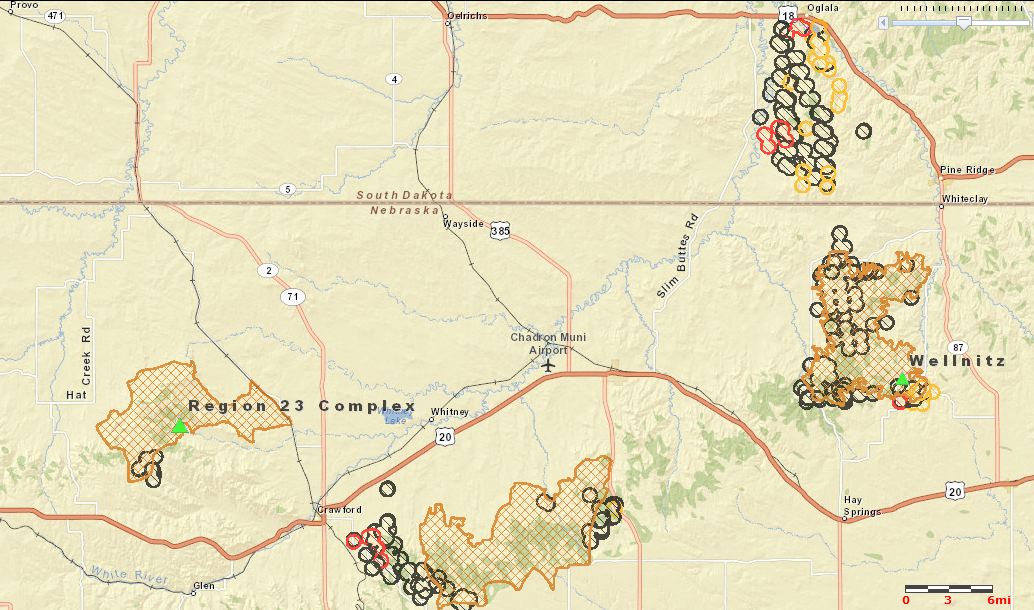
Firefighters are making progress on the two large fires in the Region 23 Complex that are south and west of Chadron, Nebraska, comprised of the Douthit Fire northwest of Crawford and the West Ash fire southeast of Crawford and south of Chadron.
The Chadron Record reported that Incident Commander Joe Lowe said in a public meeting Friday that the Douthit Fire has a control line around it but could still be susceptible to growing larger if strong winds become a problem.
The Chadron Record also had this interesting bit of information:
Crow Butte [uranium] Mine near Crawford has also been shut down and evacuated, and Lowe said the team is strategizing how to handle the potential hazardous material situation should the fire advance that far. The blaze is currently three to four miles from the mine.
The more active of the two fires, the West Ash Fire, has come close to Highways 385 and 20, requiring the temporary closure of 385. One of the DC-10 air tankers dropped at least three 10,600-gallon loads of retardant near the highways.
The Wellnitz Fire northeast of Chadron has burned about 60,000 acres in Nebraska and South Dakota.
The information below about the Region 23 Complex was sent to us at 10 p.m. September 1 by Beth Hermanson, Public Information Officer for the Rocky Mountain Incident Management Team C:
==============================================================
Region 23 Fire Complex has burned 87,555 acres and is 47% contained as of this evening. Significant progress was made on the Douthit Fire today, while West Ash remains active.
The Douthit Fire crews took advantage of yesterday’s temperatures to complete burnout operations to help secure containment lines. Firefighters worked on constructing and strengthening line, and focused mop up around structures and near the fire line, while mitigating risks.
The West Ash Fire remained active as firefighters worked on constructing and strengthening fire lines which were tested throughout the day by high erratic winds. Significant indirect efforts to provide extra protection to the city of Chadron were completed, including drops from the DC-10 Very Large Air Tanker, (VLAT) of 36,000 gallons of retardant, and heavy equipment completed lines around each home.
Near Crawford, fire officials successfully completed a five-mile burnout operation to help reinforce containment lines.
Resources continued to arrive throughout the day, with a reported 658 personnel now dedicated to the Region 23 Complex. To date, there have been no firefighter injuries.
Fire crews anticipate a busy night operational period with changing weather conditions. A cold front is expected to move in this evening, likely preceded by strong erratic winds and a thunderstorm. The Incident Management Team prepared by staffing a significantly larger night operation shift. Crews plan to take advantage of the predicted cooler temperatures and increased relative humidity to make significant progress on containment, and to continue burnout operations.
EVACUATIONS: Fire and Law Enforcement Officials strive to return evacuees’ home as soon as possible; meanwhile the following evacuations continue mandatory, including:
Residents living west of Highway 385, and south of Highway 20, Highway 385 to Hawthorne Road and all areas north of Buttermilk Road to Highway 20; including Country Club Road, Old County Club Road, and Goffena Road. This also includes Deadhorse Road to Table Road and Flag Butte Road.
Residents living on Highway 385 between Chadron City Dams and Red Cloud Camp area, both the east and west side.
Crawford area residents living from the West Ash Road south on Highway 2 for five miles, across Breakneck Road, east to West Ash Creek Road; including West Ash Creek Road, Squaw Creek Road, Saw Log Road, Horseshoe Road, Breakneck Road, Dyer Road and Crow Butte Road.
The Village of Whitney remains evacuated.


I have often said that the Northern tier of Nebraska is one of the most isolated places in the lower 48. Dont get caught in that country after 6 pm without a full fuel tank. Outside of 50,000 watt radio stations like Denver’s KOA there is little radio reception there at night.