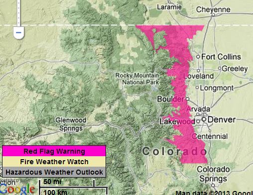
The National Weather Service issued a Red Flag Warning Wednesday afternoon for the front range of Colorado from the Wyoming border south almost to Colorado Springs. It will be in effect until 5 p.m. MT January 24. Conveniently for the weather forecasters, the extreme fire weather stops EXACTLY at the Wyoming/Colorado state line.
Here is the text from the announcement:
***
LARIMER AND BOULDER COUNTIES BETWEEN 6000 AND 9000 FEET, JEFFERSON AND WEST DOUGLAS COUNTIES ABOVE 6000 FEET, GILPIN, CLEAR CREEK, NORTHEAST PARK COUNTIES BELOW 9000 FEET-
…RED FLAG WARNING IN EFFECT UNTIL 5 PM MST THURSDAY FOR WIND AND LOW RELATIVE HUMIDITY FOR THE FRONT RANGE FOOTHILLS…
THE NATIONAL WEATHER SERVICE IN DENVER HAS ISSUED A RED FLAG WARNING FOR WIND AND LOW RELATIVE HUMIDITY…WHICH IS IN EFFECT UNTIL 5 PM MST THURSDAY.
* AFFECTED AREA…FIRE WEATHER ZONES 215 AND 216.
* TIMING…TONIGHT AND THURSDAY…WITH THE MOST CRITICAL CONDITIONS LATE TONIGHT AND THURSDAY AS WINDS INCREASE.
* WINDS…WEST 15 TO 20 MPH WITH GUSTS 30 MPH THIS EVENING INCREASING TO 20 TO 30 MPH WITH GUSTS AROUND 45 MPH BY THURSDAY AFTERNOON.
* RELATIVE HUMIDITY…SINGLE DIGIT HUMIDITIES LATE THIS AFTERNOON ONLY RECOVERING TO 25 TO 35 PERCENT TONIGHT. HUMIDITIES THEN DROPPING BACK TO AROUND 15 PERCENT THURSDAY MORNING WITH SOME IMPROVEMENT THURSDAY AFTERNOON.
* IMPACTS…EXISTING WILDFIRES OR NEW FIRE STARTS MAY EXPERIENCE RAPID FIRE GROWTH DUE TO THE VERY DRY FUELS…LOW HUMIDITIES…AND GUSTY WINDS. THE MOST CRITICAL CONDITIONS WILL OCCUR ON SOUTHERN EXPOSURES AND AREAS WITH NO SNOW COVER.
***
The map above was current as of 8:10 p.m. MT on Wednesday. Red Flag Warnings can change throughout the day as the dozens of National Weather Service offices around the country update and revise their forecasts. For the most current data, visit this NWS site.
Thanks go out to Chris.


To put the “who” in it: A big thanks to the following representatives at the state legislature who have sponsored legislation impacting wildfire mitigation and state organizational responsibilities : House [Gerou, Levy], Senate [Roberts, Nicholson]. All were members of the lower north fork commission. Nothing heard from the rest of the legislature or the governor’s office … for them, it seems that hope is their plan.
Recent news article; Colorado hopes for zero wild fires this year. Let us hope that they get their wish. If I was in the insurance game I would be shuddering. Dude, “could you pass that thing over here”.
The red flag officially changed nothing. None of the county sheriffs use the red flag warning to set fire bans/ restrictions in their counties.
No aviation assets are under contract this early in the year. I have yet to see a solicitation for bids but Colorado usually contracts for 3 or 4 SEATS.
Helo guard units at Buckley AFB can be called up by the governor but they are not IA assets due to activation time delays. C-130 aircraft at Peterson AFB are USAF reserve and are limited by the 1932 Economy Act … they have to watch things burn until the commercial assets are tapped out.
So far in Colorado if you look at the lack of legislation, hope is the plan.
Dry again, red flag conditions. After last years horrific Colorado fire storms does this WARNING mean anything to anyone or agency. Are there Type I helicopter (s) or LAT/VLAT (s) in Colorado for immediate use? Immediate use: air resource delivering water or retardant on a fire within 20 minutes or less after detection in a critical area. Or, why get too excited its going to go big anyway.
Maybe a sign of things to come for 2013 with global warming and climate change!?!?