(UPDATE at 9:14 p.m. MDT, July 6, 2013)
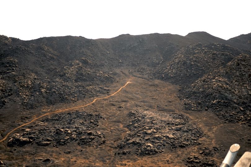
We added this photo of the entrapment site on the Yarnell Hill Fire. The dozer line was punched in after the incident to facilitate the removal of the bodies, which were at the end of the line. The photo was taken by Wade Ward of the Prescott FD, and is used here with permission.
****
(Originally published at 8:53 MDT, July 6, 2013)
Robert Ford, who grew up in Prescott, studied some of the information that is available about the wind when the 19 members of the Granite Mountain Hotshots were killed on the Yarnell Fire June 30. His message is below, with a few notes from me [in brackets].
****
“A graphic showing the “safety zone” and shelter deployment site is here.”
[Note from Bill: the times in that article are approximately 6 hours in error. We were told by Carrie Dennett of the Arizona State Forestry Division that their office received notice that shelters had been deployed at 4:47 local time, Mountain STANDARD Time. But they were not in direct communication with firefighters. The information had to travel up a chain of command and may have been delayed. I have not seen definitive word on when the deployment took place.]
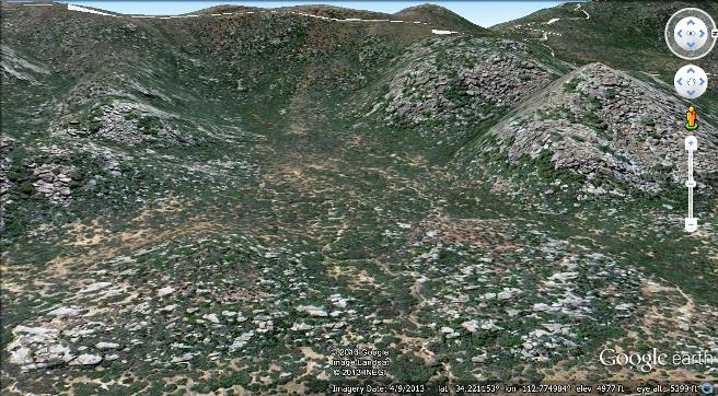
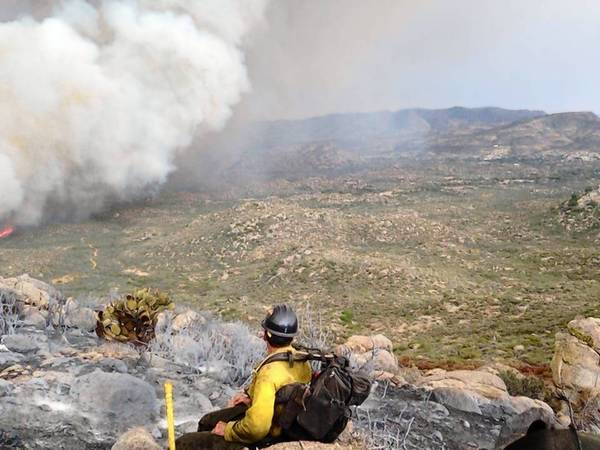
“A Google Earth rough approximation of the high res photo above is attached.

Looking due west, eye altitude about 5400 feet. The approx. shelter site is 34.221416,-112.775796. The Landsat imagery was acquired last May; note the fuel, when compared to the Facebook photo above.
If you have Google Earth, it is also easy to duplicate the camera location of the time-lapse video (posted on your site) [embedded again above] purportedly shot from “Congress”; actually I’ve determined it was shot just west of the Date Creek Road (dirt – you can see the dust clouds from passing vehicles) just North of the intersection with Highway 89. The time-lapse video, looking N45E, shows the fire just cresting the ridge starting about one mile due Northwest of the shelter deployment site, then flashing to the right (southeast) along the ridge-line towards the deploy site. The smoke then obscures how the fire must have flashed over the ridge just 1500 feet west of the deploy site. In any event, the video shows how very rapidly the wind moved through the natural basin of the deploy site; probably aided by a natural venturi effect from the walls of the basin; also note that by the end of the video a trailing vortice formed off the ridge crest has actually moved the plume locally down (by 2000 feet !) to about the elevation of the Camera. It was an amphitheater of death for all of those brave men. This also explains why some men were found “outside” their shelters; that’s because a wind of unimaginable proportion, moving locally upward, lifted their shelters away.
Well thank you and you are very welcome to use whatever of this information you please. I have learned so very much from your site; it contains absolutely the best no-nonsense web coverage of this fire. In the event you wondered, I used to model the effects of wind on the topography surrounding astronomical observatories; but I never had to deal with a surface boundary condition as defined by a wildfire: that adds an order of magnitude of complexity to the simulation. I would like to presume the Feds will realize the importance of contracting a surface topography wind effect model for this fire, as a component of their investigation; If you have any say in the matter I am happy to recommend the best people; it’s not cheap as it requires supercomputer time.
Finally, I needed to relate that I grew up in Prescott; fighting fires was a rite of passage. You would have thought that by now the FS would have developed a weather-topography-fuel load model to deal with this sort of thing.
Well now they will do so.”
****
In a follow-up message, Mr. Ford wrote:
****

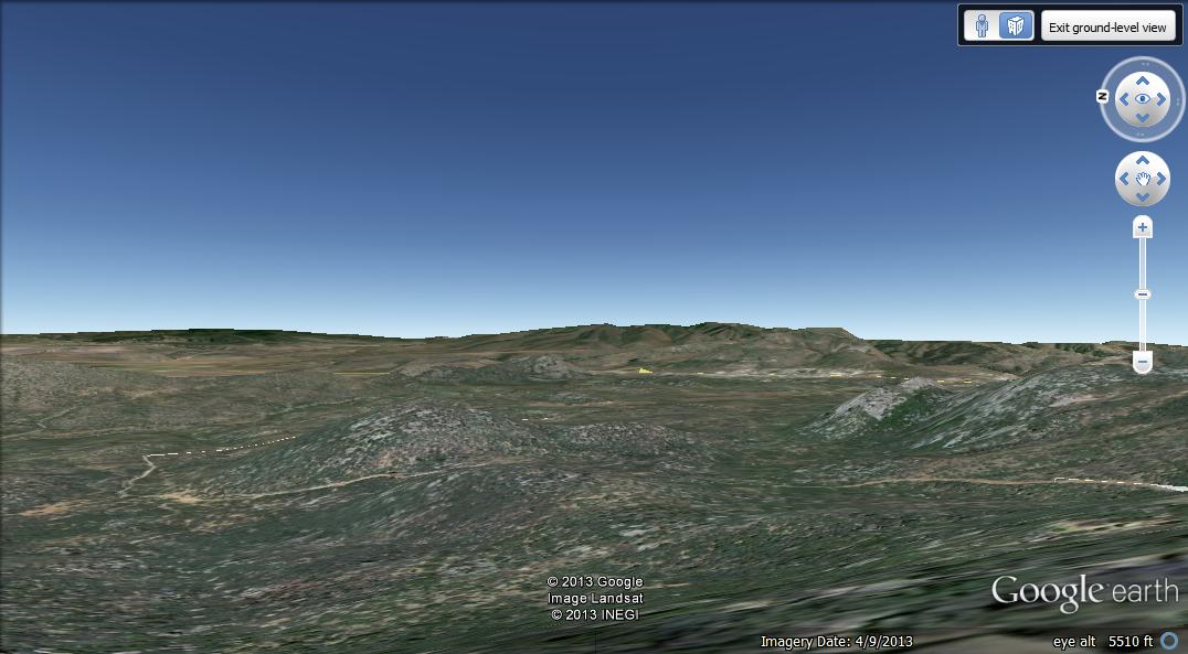
“For your information, I was able to determine the approximate vantage point of the photo [added above] as looking due East from 34.227291,-112.788630, at an eye elevation of 5,510 feet.

This location [above] is just off (east of) the trail on the ridge crest-line, and is located about 0.82 miles Northwest (as the crow flies; longer by trail) of the shelter deploy site (subject of my previous post). Now given the vantage point vector as due East, the plume appears to be moving southeast; thus the fire front (barely visible in the photo) is being driven directly towards Glen ilah.”
****
Follow-up from Bill:
A comment left on one of our posts by “lone ranger” found an article that included information provided by the National Fire Administration, which is the first I’ve head that they had anything to do with this incident. I would be hesitant to trust this information. The report says the firefighters initially took refuge in a burned area, the black, then left that site and deployed their fire shelters later in another area as they headed toward a ranch which was to be their safety zone.
There continues to be confusion about the times. This may be partly due to the fact that Arizona is not on Daylight Savings Time like most of the United States. They use Mountain STANDARD Time.
A blog called Cliff Mass posted a very clear and detailed explanation of the weather. His last line in the article:
A number of media outlets called the strong winds unpredictable and random. This is not correct, as shown by the information I provided above.
Chuck Bushey told us that once upon a time there were:
…Fire Behavior Service Centers in various regions, warning crews in real time about t-storms (or other events) heading their direction that they couldn’t yet see and getting them into the black. The Southwest use to run a FBSC with a qualified Fire Behavior Analyst (FBAN) but I think they dropped it as did everyone else.


I was a Little Tujunga Hot Shot from the start (1970) on the Angeles National Forest in Southern California. At that time the 1966 Loop Fire and the loss of 12 El Cariso Hot Shots was fresh in our minds. The Angeles National Forest commanded Five Hot Shot Crews for a least two decades after the Loop Fire incident without any fire shelters deployments as I understand it. Were all these crews and their supervisors just lucky or did they take to heart the tragic lessons learned from the Rattlesnake and Loop Fires (Ten Standard Firefighting Orders and the 13 Situations).
The Little Tujunga Hot Shots carried fire with them and we always kept one foot in the black (Direct line construction). My old supervisor said that if the Granite Mountain Hotshots were cutting Indirect line and a thunderstorm approaching, they may have been prevented from reaching their safety zone. I agree.
Larry Sall
3rd Hook
Little Tujunga Hot Shots 1970/71
Without question one of the top reasons for compiling and analyzing fire weather information is to increase the level of safety for firefighters on the fireline. We have the ability to precisely monitor weather with satellites giving us the opportunity to have plenty of advance notice of changing weather conditions at the fire. Why do we not have a simple and reliable system to make this lifesaving information available to those who really need it? The brave crews who are working close to the fire need to be informed. They need to be warned as soon as possible. There are no technological obstacles preventing us from devising and implementing such a system. We need to save lives, we need to get this done.
It seems that the Stanton RAWS is relied upon for data regarding the Yarnell Hill Fire. There is another station, E2144, almost due north located in Peeples Valley at 4669′ and less than 4.5 miles from the incident site (5000-5050′). I would think it’s data is probably more representative of the conditions on the fire than that of Stanton’s at 3600′ and over 4.5 miles away to the southeast in the mouth of a canyon that drains from Yarnell. And I wonder if that canyon’s drainage played a role, at some point, in “draining off” some of the denser air from the storm outflow creating a localized breeze through the Yarnell area.
Regardless, without a doubt the burnover was extremely intense. Asphyxia might have reduced those final excruciating moments for the firefighters.
LR
After hearing the weather read for Las Vegas, NV on my local “unit” the other day by a dispatcher (Note: we are nowhere near Las Vegas), there are lots of latent factors and “swiss cheese holes” lining up this year.
‘Nuff said.