(UPDATE at 1:40 p.m. PT, June 11, 2014)
The Incident Management Team reports that the Two Bulls Fire has not grown over the last 24 hours with the exception of a small 1/4 acre spot fire that was detected and suppressed outside the main perimeter. The fire is listed at 6,906 acres and 40 percent containment. This will be our last update unless the status of the fire changes dramatically.
****
(UPDATE at 8:20 a.m. PT, June 10, 2014)
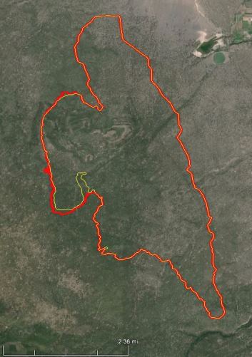
The Two Bulls Fire three miles west of Bend, Oregon grew by about 100 acres on Monday, bringing the total number of burned acres to approximately 6,900. All of the spread was on the west side of the fire. Fire managers said they have a fire line around the east and south sides, while line construction continues on the west side.
Evacuation notices are still in effect for 50 homes. No structures have burned in the fire.
Investigators located the points of origin of the two fires that burned together to form what became the Two Bulls Fire. They collected evidence and announced that the blazes were human caused. Cascade Timberlands has put up a $2,000 reward for information that leads to a successful conviction.
****
(UPDATE at 8:55 a.m. PT, June 9, 2014)
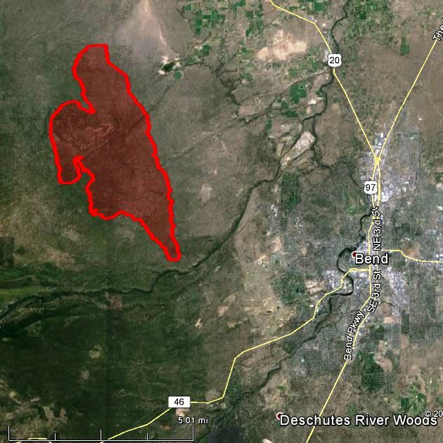
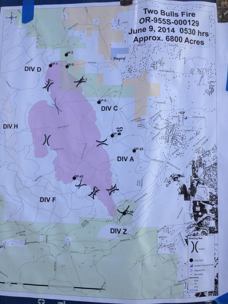
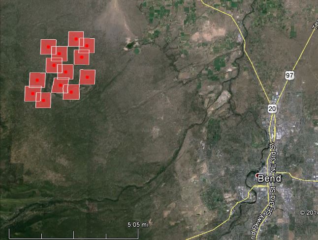
Finally we have a good map, above, of the Two Bulls Fire three miles west of Bend, Oregon. Fire officials said the latest mapping puts it at 6,800 acres. Firefighters have completed a fireline around the east and south sides, but they are only calling it five percent contained.
Below is an excerpt from information provided Monday morning by the Incident Management Team:
Good progress was made both yesterday during the day and night with firefighters taking advantage of some calmer weather conditions. The priority of securing fireline around the eastern and southern portions of the fire was met and it is anticipated that hoselines will be put into place along that line by the end of today with some mop-up activities commencing there. Some of the available crews from the east flank divisions were reassigned to the western flank of the fire today to help in securing fireline on that portion. Structure protection task forces mobilized under the Oregon State Conflagration Act continue to work around the threatened structures and have contingency plans in place to help protect the watershed facilities if the fire jumps containment lines.
TWITTER: @twobullsfire,
Dry weather conditions will continue to keep temperatures in the upper 70’s and lower 80’s and relative humidity dipping below 20%. The main concern for today will be hold the lines on the southern portion of the fire and out of the City of Bend’s watershed, as winds are forecasted to get gusty from the northwest at 10-18 mph in the afternoon as a weak upper level disturbance moves over the area.
• 6,800 acres consisting of heavy brush and timber
• 250 homes threatened with 50 remaining under Level III Evacuation
• No structures lost or damaged
• No injuries
• Cause under investigation
• 5% containment
• 11 helicopters, 46 engines, 11 dozers, and 708 personnel assigned to the fire
• Estimated costs to date- $1.23 million Public Information Meeting
An informational meeting open to all public and media will be held Monday evening at 6:00 pm at Bend High School, located at 230 NE 6th St in Bend. Fire representatives will give a current and expected fire briefing and will be available to address questions and concerns.
The Bend Bulletin has an interactive map showing the evacuation areas.
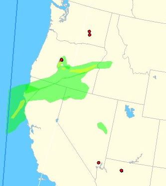
Map of smoke created by the Two Bulls Fire:
The video below is a time-lapse of the fire burning at night
On FireAviation.com is a video of air tankers taking off at Redmond, OR en route to drop retardant on the Two Bulls Fire.
****
(UPDATE at 9 p.m. PT, June 8, 2014)
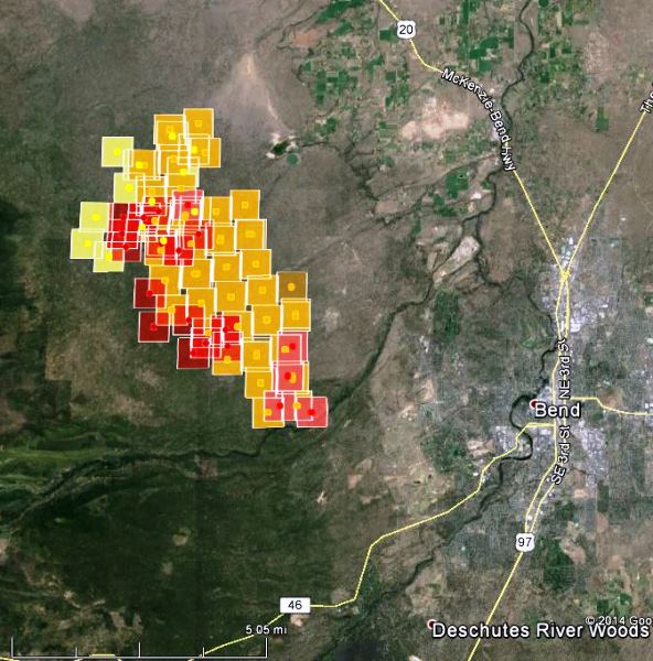
The map of the Two Bulls Fire below shows that most of the heat detected by the satellite at 3:14 p.m PT today was on the west side of the fire, and as of that time, there had been no huge additional gains in acreage on Sunday — but the burning period is not yet over. There could still be some significant fire spread late in the afternoon.
As of 1 p.m. officials reported that no structures had burned in the fire.
KTVZ reported that fire officials said preliminary containment lines have been built on the south and east sides of the fire. But there would be no change from the zero percent containment figure until crews see it tested by the heat of the day.
The Bend Bulletin has an interactive map showing the evacuation areas.
The weather early Sunday afternoon has been slightly more in favor of the firefighters than it was on Saturday when the fire made a big run toward the south and southeast. The relative humidity has been a few points higher, and the wind gusts, which have been coming out of the northwest, north, and northeast, have been several miles per hour slower — all contributing to more moderate fire behavior.
The winds later Sunday afternoon are expected to increase in the fire area and should be out of the north at 14 mph gusting up to 18 around sunset, then decreasing during the night to 3 to 6 mph out of the northwest and west. These late afternoon conditions could challenge firefighters and the firelines they have constructed.
A possible factor affecting the higher fire activity on the west side of the fire as opposed to the east side, other than the wind direction and efforts by firefighters, is the difference in the vegetation. East of the fire the vegetation is less dense, with wider spacing between the tree canopies, while the opposite condition exists on the west side. Firefighters working from the ground and aviation resources dropping water and retardant can more easily slow the spread of the fire when the fuels are less abundant.
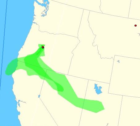
The map below shows the distribution of smoke from the Two Bulls Fire at 3:37 p.m. on Sunday.
Here’s a map of the #TwoBullsFire fire perimeter. Green is @DesNatlForest and white is protected by @ORDeptForestry pic.twitter.com/fnbcIUTw9J
— Central OR Fire Info (@CentralORFire) June 8, 2014
Evacuations map:
Here is the same image with increased transparency as requested by @FlipFlopSounds. #TwoBullsFire pic.twitter.com/ACZ9xICgSX — Travis Knudsen (@TravisKTVZ) June 8, 2014
#TwoBullsFire from Tyler Rd. Taken about an hour ago before evacuations. pic.twitter.com/gJl2yB6y2A
— Meaghan (@MeaghanBullLMT) June 7, 2014
Wow! “@SethPhillipsWx: @NWSMedford showing the projected path of the smoke from the #TwoBullsFire over next 24hrs pic.twitter.com/wEVDvGQVdM” — Go Team Squirrel! (@Team_Squirrel) June 8, 2014
They later added Bellatazza Plaza in Downtown Bend on Wall St. to the locations listed below. All three information sites will be available until 6:30 p.m.
Want info on the #TwoBullsFire? Visit the information officers on the top of Pilot Butte or at NW Crossing @NWXBend
— Central OR Fire Info (@CentralORFire) June 8, 2014
Last night from Pilot Butte. Fire grew to 6,200 acres overnight. #TwoBullsFire pic.twitter.com/XZ2LJO2HXo — Go Team Squirrel! (@Team_Squirrel) June 8, 2014
****
(UPDATE at 11:04 a.m. PT, June 8, 2014)
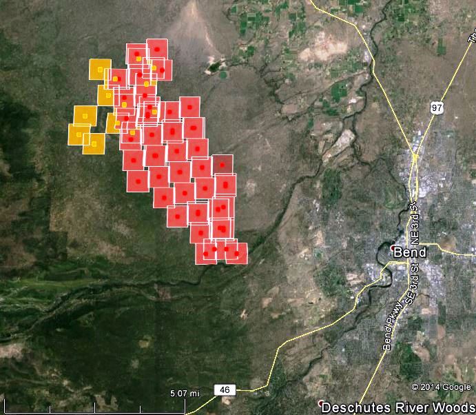
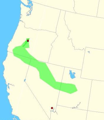
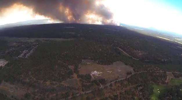
The Two Bulls Fire west of Bend, Oregon grew substantially late Saturday afternoon and into the night. Initially about a mile west of Upper Tumalo Reservoir, it moved southeast to within four miles west of Bend. The last estimate of the fire’s size provided Saturday afternoon by incident management personnel was 250 acres. Using the map of the fire above, we are estimating that it has burned at least 5,000 acres. (UPDATE at 8:52 a.m.: KTVZ is reporting that the Two Bulls fire has burned 6,180 acres and the incident management personnel are reporting there is zero percent containment.) About 250 homes have been evacuated and another 2,000 are threatened. Sunday morning at 8:30 a.m. PT in Bend the weather has moderated with the relative humidity at 55 percent and a slight south wind at 2 mph. Those conditions should slow the spread of the fire considerably. Here is a link to the current weather at the Tumalo Ridge weather station. The map below shows the path of the wind-blown smoke from the Two Bulls Fire in Oregon.
OR Dept of Forestry Team II, with OR State Fire Marshall Green Team will assume Unified Command of the #TwoBullsFire at noon today. — Central OR Fire Info (@CentralORFire) June 8, 2014
(All three of the the Oregon Department of Forestry’s Type 2 Incident Management Teams were listed as unavailable on the Northwest Interagency Coordination Center’s web site on Friday. There were no ODF Type 1 IMTs listed. The Incident Commander for “ODF Team 2” is listed as Cline. The mission of Central Oregon Fire is “Providing support to the Prineville District of the BLM, Deschutes and Ochoco NFs and Prineville/Sisters Units of the Central Oregon District of the ODF”)
MD-87 Aero Tanker over Shevlin Commons #TwoBullsFire pic.twitter.com/JVtEmpX8Kp — Steve Crozier (@sgec) June 8, 2014
#TwoBullsFire more firefighter photos from the front lines. We’re working to gather more information on evacuations . pic.twitter.com/lAaLoxnbDg — Renee Nelson (@ReneeKTVZ) June 8, 2014
On Saturday a wedding about three miles east of the Two Bulls Fire near Bend, Oregon had to be evacuated just before the bride walked down the aisle. Check out the story and the amazing photo of the bride and groom with a convection column of smoke in the background. **** (Originally published at 8:18 p.m. PT, June 7, 2014) The Two Bulls Fire that started Saturday afternoon west of Tumalo Reservoir about 10 miles northwest of Bend, Oregon is spreading rapidly toward the south. Two fires in the same general area are being managed as one. The wind-driven fires have led to evacuations, with evacuees initially being directed to go to Cascade Middle School in Bend. The fires have burned at least 250 acres.
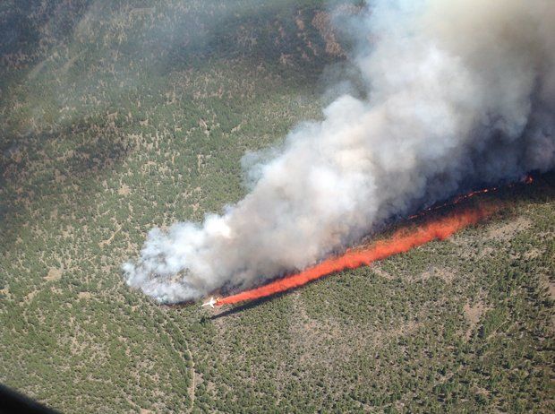
The fires are burning in a mix of Deschutes National Forest and private lands protected by the Oregon Department of Forestry. The photo below shows Tanker 101, an MD-87, making one of its first drops ever on a fire. It just became certified and reported for duty at Redmond, Oregon on June 4, 2014.
The video below is from time-lapse photos taken in Bend. It is very impressive — the camera has a clear view of the smoke.
Aerial view of the #TwoBullsFire #inbend. Follow @CentralORFire for updates @KTVZ #bendfire pic.twitter.com/QRJwRZmL5G — make local habit (@makelocalhabit) June 8, 2014
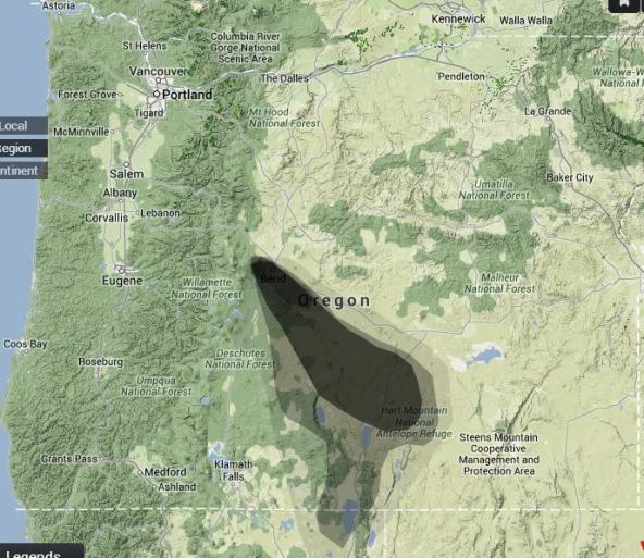
The map below shows the trajectory of smoke from the Two Bulls Fire.
Live cameras that may show smoke from the fire: EyeOnBend and BendWeather. Current weather in Bend.

Nice photo Jim!
Fire size mapped at over 6000 acres, here’s the updated satellite:
https://twitter.com/alanbrandtphoto/status/475641680742207488/photo/1
Correction: evacuees now directed to go to High Desert Middle School.
Correction: Its Oregon Department of Forestry Team 2 which is taking over the fire tomorrow. All three of ODF’s IMT’s are Type 1.
None of Oregon’s department of forestry teams are type one they are all type 2!! And as of Friday they didn’t even have an IMT available!
According to the Northwest Area Coordination Center, the ODF does not have any Type 1 IMTs. As of Friday, June 6, they had three Type 2 IMTs, but they were all listed as being unavailable. The Northwest area has two interagency Type 1 IMTs listed as available, and eight interagency Type 2 IMTs available.
In spite of those facts, for the last 14 hours the Two Bulls Fire’s InciWeb page had started the description of the fire with this:
ODF does not status their teams through NWCC as they are primarily for use in Oregon on ODF protected lands. ODF’s landowners have made a significant investment in these resources and rightfully so should have some say over the use of those teams. ODF’s teams have regularly gone to Alaska over the past few years under the NW compact and managed Type 1 fires. They are not a national resource so they don’t worry about NWCC showing available or unavailable.
Since the Feds will not recognize any Type 1 Teams that are not controlled by them, for whatever reason, does not mean that States cannot have Type 1 Teams. All three of ODF’s teams meet all the requirements of a Type 1 Team. I have worked for federal Type 1 Teams and the ODF teams are without question on par and in some cases can run a more efficient and effective Type 1 organization.
Not trying to start a pissing match over Feds vs. State, but there is some ego’s involved in the team typing.
Bob – Curious where you are getting your information on ODF’s team typing?