(UPDATED at 4 p.m. April 19, 2015)
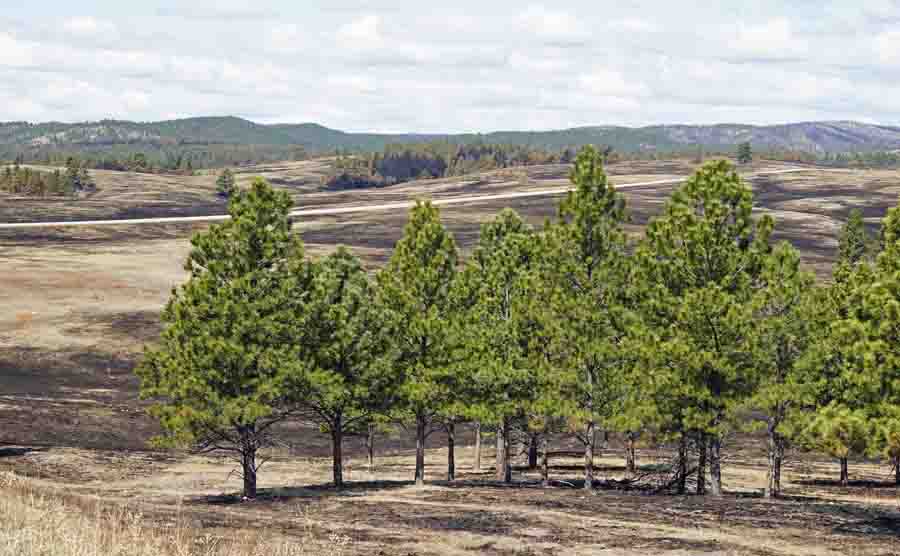
After being out of town for a while, today we saw the Cold Brook escaped prescribed fire in Wind Cave National Park in South Dakota for the first time. Our initial impression was that a very small percentage of the Ponderosa Pine trees lost their canopies to the fire; the mortality was very low. This is largely due to a series of prescribed fires that were conducted in the area about 13 to 16 years ago. Those burns eliminated some trees and “raised the canopy” on many; that is, some of the lower limbs were burned off reducing the ladder fuels that could later carry a fire into the crowns.
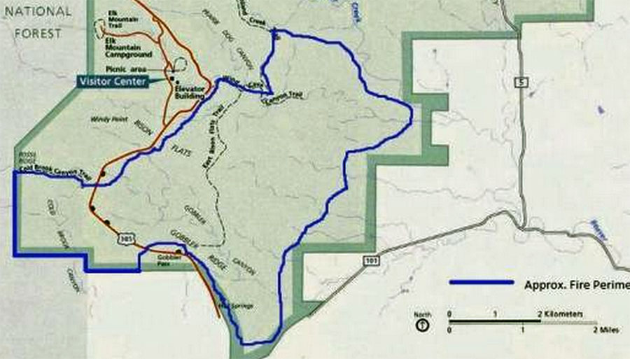
Approximately 5,420 acres burned outside the prescribed fire unit, all within the National Park.
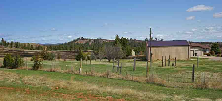
The fire would have burned private land outside the park if the Casey Ranch south of the park had not been added a few years ago. The fire burned quite a few acres east of Highway 385 and south of the former park boundary.
In that area, a residence that remains on private land had the fire burn right up to their back yard, as you can see in the photo below.
When the fire escaped, it ran to the east for about four to five miles.
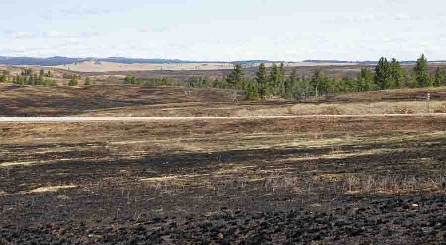
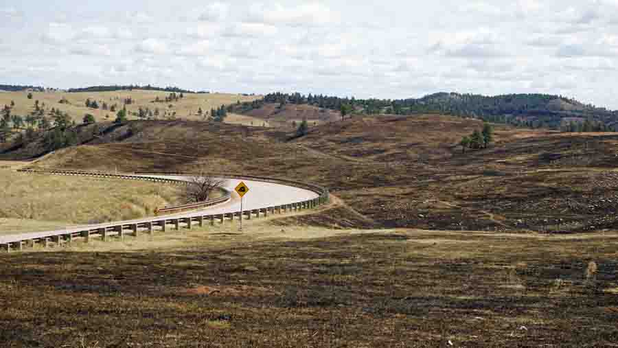
All of these photos in today’s update were taken by Bill Gabbert. Click on them to see larger versions.
****
(UPDATED at 6:25 a.m. MDT, April 15, 2015)
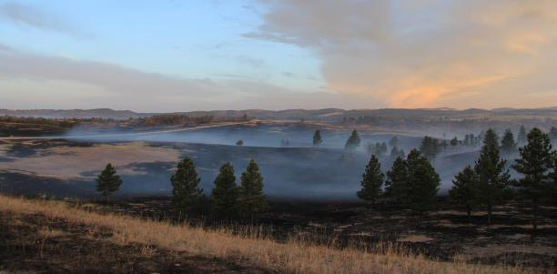
The incident commander of the Cold Brook fire that escaped from a prescribed fire in Wind Cave National Park called it 80 percent contained at 4 p.m. on Wednesday. Demobilization of firefighting resources has started for the 6,420-acre fire.
****
(UPDATED at 3:10 p.m. MDT, April 15, 2015)
Wind Cave National Park provided the following information at 10 a.m. today about the Cold Brook Fire that escaped from a prescribed fire:
Firefighters working day and night shifts have been camping at Butler Park in Hot Springs. The Type 3 Incident Management Team (IMT) has retained management of this incident. The Type 2 IMT, Rocky Mountain Team Black, which was ordered as a contingency, arrived from Colorado yesterday and agrees that current leadership has a good handle on the situation.
The park spokesperson, Tom Farrell, said the fire is currently estimated at 6,000 acres – 1,000 acres were within the prescribed burn unit and an additional 5,000 acres have burned outside the prescribed burn unit.
A U.S. Forest Service InfraRed mapping plane, N149Z, flew over the fire Tuesday night, enabling firefighters to get an accurate map of the extent of the fire. This was the first assignment of an IR plane on an actual going fire this year. A couple of weeks ago they mapped the 2014 King Fire in California for a BAER team.
****
(UPDATED at 7:30 p.m. MDT, April 14, 2015)
Tom Farrell, a spokesperson for Wind Cave National Park, now reports the Cold Creek fire has burned 5,400 acres, in addition to 1,100 acres inside the boundary of the original prescribed fire.
Firefighters will get a bit of a break with the weather on Wednesday. The forecast calls for 56 degrees, winds out of the northwest at 10 mph, close to 100 percent cloud cover, and most importantly, a 62 percent chance of rain (about 0.13 inch) in the afternoon. And as a bonus, about an inch of snow late Wednesday night.
****
(UPDATED at 4:44 p.m. MDT, April 14, 2015)
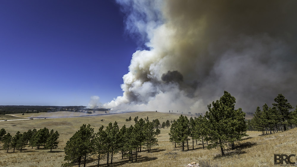
As of 11 a.m. MDT on Tuesday the Cold Brook Fire that escaped from a prescribed fire in Wind Cave National Park had burned approximately 4,500 acres outside the intended boundary of the 1,000-acre prescribed fire. Tom Farrell, spokesperson for the Park, said firefighters worked through the night to complete a fireline around 80 percent of the perimeter and on Monday hoped to finish the remaining 20 percent. As of that 11 a.m. report, the wildfire was entirely within the borders of the park, which includes the new portion that was added on the south side after the National Park Service purchased the Casey ranch.
The fire is being managed as a Type 3 incident, but a Type 2 Incident Management Team has been ordered.
Firefighting resources working the fire:
- 2 South Dakota Air National Guard Blackhawk helicopters,
- 3 Single Engine Air Tankers,
- 2 Type 1 helicopters are on order.
- 70 firefighters
The helicopters are filling their water buckets at Cold Brook Reservoir north of Hot Springs.
****
(UPDATED at 9 a.m. MDT, April 14, 2015)
A Rocky Mountain Type 2 Incident Management Team (Team Black) has been ordered for the Cold Brook Fire, which escaped from a prescribed fire in Wind Cave National Park.
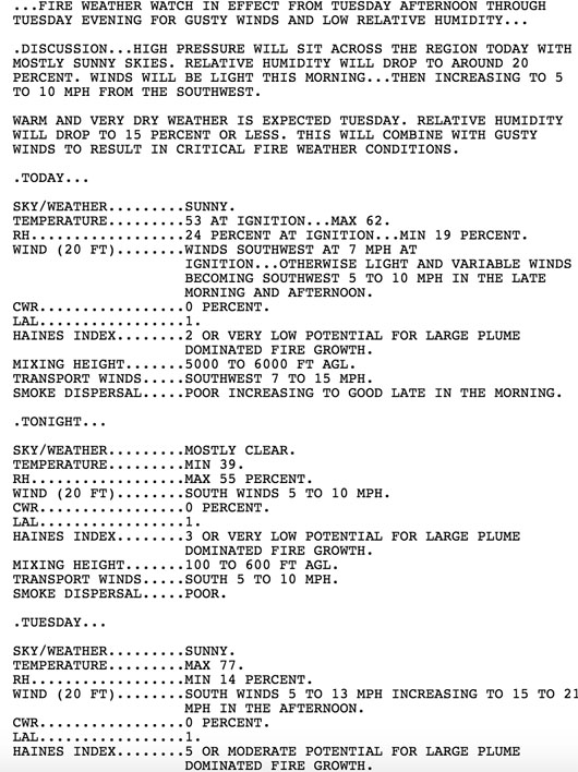
Below is the Spot Weather Forecast that was issued Monday at 6:09 a.m. April 13, the day of the prescribed fire. Ignition was planned for 10 a.m. You can view the entire document HERE.
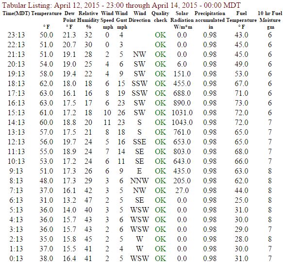
Below is the actual weather for April 13, the day of ignition, recorded at Elk Mountain, a mile or so away from the burn. The fire was declared an escape around 1 p.m. that day.
****
(Originally published at 8:38 p.m. MDT, April 13, 2015)
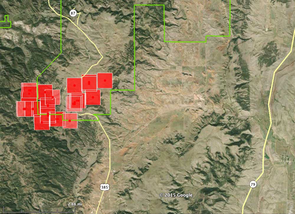
The Cold Brook #2 prescribed fire that we covered earlier on Monday, April 13. escaped at about 1 p.m. As of 6 p.m. the wildfire had burned an additional 1,000 acres all inside Wind Cave National Park, according to Tom Farrell, spokesperson for the Park.
“Several hours into the Unit 2 Cold Brook Burn this morning, an unpredicted fire whirl, or dust devil, picked up burning ash and carried material over 100 yards outside of the planned burn area into high grass”, Mr. Farrell said. “Pushed by high westerly winds, the fire quickly moved beyond containment efforts.”
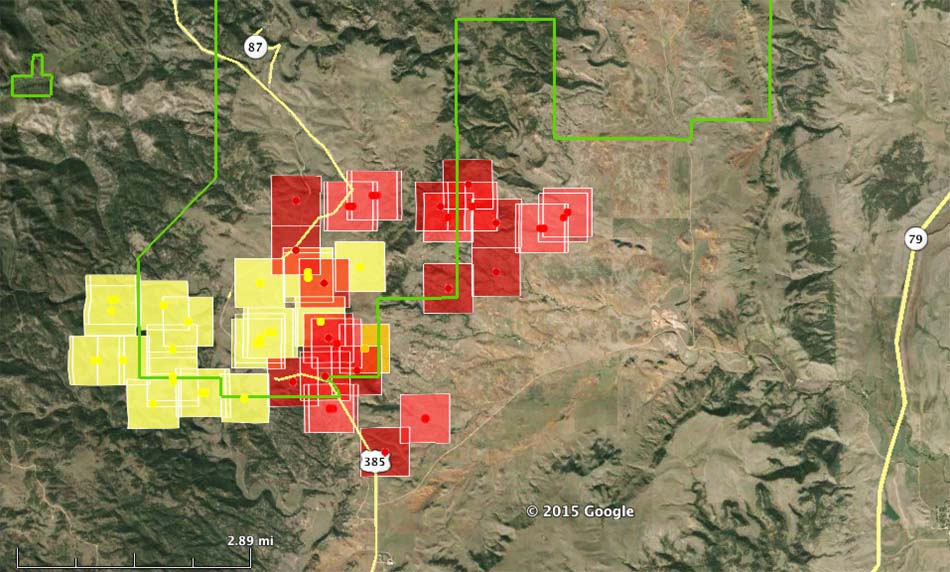
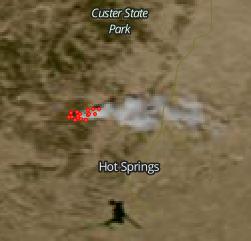
The prescribed fire was intended to be 1,000 acres entirely on the west side of Highway 385 in Wind Cave National Park (see the maps above and below) but according to the heat detected by a satellite it spread to the east, crossing the highway burning toward the “Keyhole” area in the National Park boundary, shown in green on the map. The green boundary on the south side of the park became out of date in 2001 when several thousand acres of the privately owned Casey Ranch were purchased and added in that area.
Benjamin Carstens sent us the time lapse video below of the prescribed fire, telling us:
The video is comprised of 380 pictures taken over a period of 4 hours. I had it set to run longer but once the fire got out of control I felt like it was best for me to leave!
It appears that you can see the fire crossing the highway near the end of the video.
The map below shows Units 1, 2, and 3 of the Cold Brook prescribed fire project. Units 1 and 3 were burned last fall, and Unit 2 was attempted on Monday.
Fire engines and hand crews have been brought in from nearby agencies to assist the 38 firefighters already on the ground; in addition, air resources have been ordered to include 2 South Dakota Air National Guard Blackhawk helicopters and a Single Engine Air Tanker. There are 70 people assigned to the fire with no estimated time of containment.
A weather station a couple of miles away from the prescribed fire recorded on Monday afternoon winds of 5 to 10 mph with gusts to 26 mph and a minimum relative humidity of 16 percent.
A Red Flag Warning takes effect at noon on Tuesday, April 14, which is expected to bring southwest winds of 15 to 25 mph with gusts to 35, and a relative humidity of 10 to 15 percent. On Monday the area was under a Fire Weather Watch.

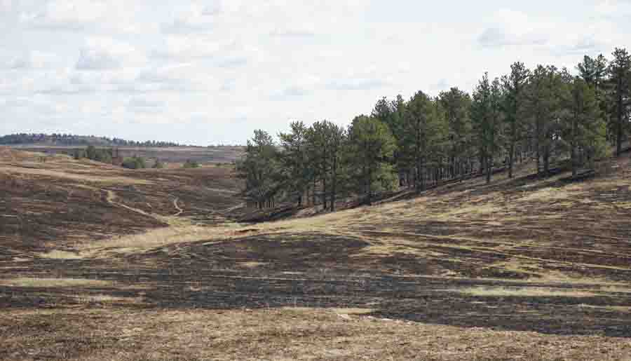
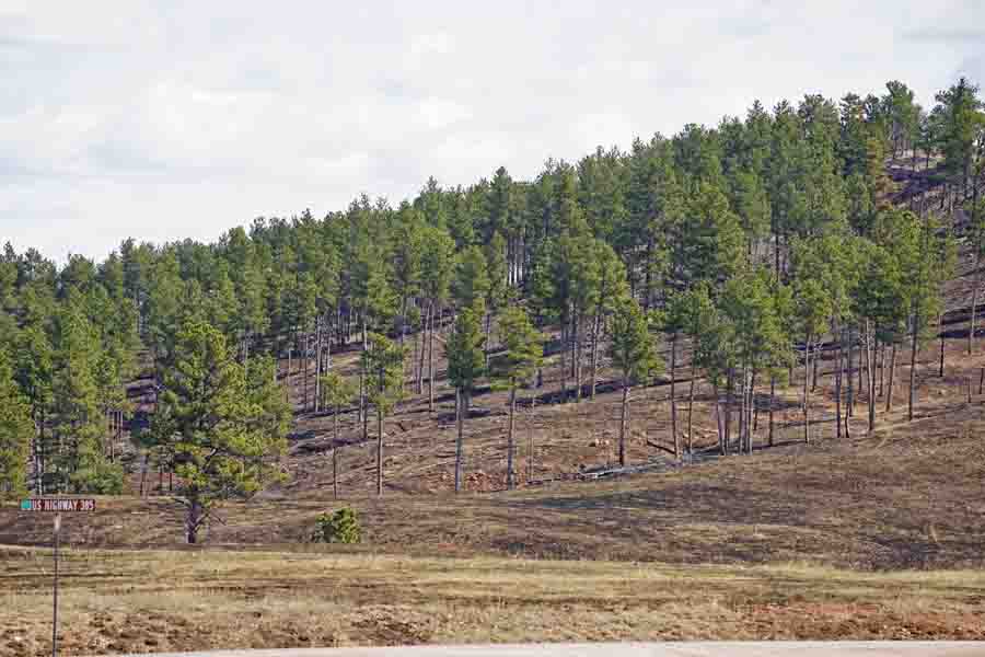

Today we added seven post-fire photos of the Cold Brook Fire.
When are these Land Managers ever going to get it figured out: never try a prescribed burn because there is always a risk of an “escape”; then let Mother Nature and our friends and neighbors determine when fire visits our fire-dependent ecosystems. Then everyone can stand back, wringing their hands, claiming it was a force of Nature and bad fire weather conditions and Pine Beetles and fireworks and exploding targets and urban terrorists, and the prescribed fire naysayers will have no one to blame. See, an easy solution to a complex problem. And we’ll never have massive wildfires again – RIGHT!
“Never rush to burn, the brush will still be there next year” said a very wise man.
Your very welcome Ryan. Stay safe! The fire season looks like it could be a bad one this year.
Since I’m not privy to (or do I know where to get) total prescribed fire acres attempted by agencies nation wide…. It’d be interesting to see how many acres have been accomplished so far this year WITHOUT the need for an IMT or other than on-site resources to help contain escaped RX fires.
Also, I would say that the Haines was pretty spot-on… There is nothing in any of those photos that indicates a “large plume dominated” fire was present. Just because a fire spots, doesn’t mean that the Haines index is high. Plus, I would be more inclined to rely on a local WX forecast than a document being produce in another state for a national audience. Although, it never hurts to cover all the bases.
The WFAS Haines Index was calculated from the Monday morning 12z Rapid City upper air sounding. Thus, the source data was local to the burn.
Paul- since I am familiar with the documents but not necessarily the way they are built, the upper air soundings are pulled from each respective WX forecast office and then compiled??
And if that is the case, why such the discrepancy in Haines??? Soundings should’ve read the same numbers….
Just a groud pounder trying to learn, not create drama.
Ryan,
The upper air network of stations is completely separate from the network of NWS forecast offices. Only a few are even located in the same city. Rapid City happens to be one of those. Thus, your statement that the upper air soundings are compiled from each NWS office is inaccurate.
The Haines Index on the spot forecast in question was not derived from the actual sounding but rather from a computer model of what it was forecast to be. It should be noted that most spot forecasts are computer generated. In this case the model was not very good.
Thanks Paul, so contrary to my first statement…. the national product would’ve been the more accurate document to referenence in regard to Haines. It’s small intricacies that don’t filter down to the lower operations level. At the FIRB level I’d look at that spot and assume it was as accurate as it gets. Much appreciated.
OK
This all fine but with the number of Red Flag Warnings circulating the last 3-4 weeks with little or no moisture…
Could one consider the weather history and MAYBE have some consideration for night burns? 10 yrs ago on some TNC burns…1100 and 1300 test proved squirrelly and were conducted at 2000 local time and done overnite..
Just one point of view looking at it from an EM standpoint seeing the last 5 year history in RX fire activity that could go off reservation and creating larger concerns for more than just Federal and management burn boundaries.
Just a liitle observation….take it for what you will
At least in some states, night burning may not be allowed due to smoke considerations. Some smoke permits for Colorado, for example, limit burning to times with good ventilation (during the heat of the day) and cut off ignitions one hour prior to sunset. Good for getting the smoke out, but limiting when fire behavior is at the edge of the prescription.
At times despite the best of planning and operational efforts a single event occurs to change everything. Despite huge, improvements in weather forecasting over the last few years a very local sudden change such as a fire whirl/dust devil can come up out of nowhere and alter all the expected results.
Anyone who has ever fought fire in the black Hills knows how unpredictable the winds are here. I don’t think they should have lit it yesterday, but hope that my friends and colleagues stay safe and get it contained quickly.
With the Tuesday morning winds increasing as temps rise and humidity is decreasing, what is the rate of growth of this wildfire, and its direction of spread this morning?
With the wind shift later on with possible storm development, how will this fiasco be contained without damage to private properties?
Thanks for putting that up Bill.
Looked like just another regular day to me. Nothing out of the ordinary.
At least in my country, which is similar.
Looks like the Haines Index was a 5 according to WFAS.
http://www.wfas.net/images/firedanger/haines.png
The Spot Weather Forecast issued early that morning said the Haines Index was 2, “very low potential for large plume dominated fire growth”.
Bad forecast on the Haines Index!
I believe that the Haines Index is a calculation of factors, not a “prediction”. Besides, fire whirls happen on low Haines Index’s as well as high. http://www.firebreak.com.au/haines.html
Glad that it stayed in the boundary.
If it is not too early to ask, what about the Haines Index for the day?
How does that fit into a RX fire?
Glad no one was hurt, fire whirls are nasty.
Bill—
Maybe you should mention that these are the same guys who lost the Belle Fourche Rx fire at Devils Tower in 2013, and that like in that fire there was a front scheduled to pass through w/i 8 hours of ignition. When are they going to get their act together?