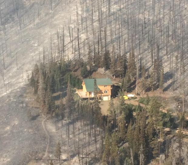
Damage assessment teams report 96 homes destroyed in the Blue Cut Fire

(UPDATED at 9:39 a.m. PDT August 20, 2016)

There was very little growth of the Blue Cut Fire on Friday. As on Thursday, the east side of the fire was fairly quiet, while there is still fire activity on the west side, especially east and southeast of Wrightwood.

The incident management team is calling it 37,020 acres. On Saturday morning they revised upward the estimate of the number of structures destroyed, to 105 homes and 213 minor structures. Some evacuations are still in place.

****

(UPDATED at 4:15 p.m. PDT August 19, 2016)

CAL FIRE Public Information Officer Daniel Berlant reported this afternoon that Damage Assessment Teams estimate that 96 homes and 213 outbuildings have been destroyed in the Blue Cut Fire.

The fire has burned approximately 39,000 acres north of San Bernardino, California, according to the incident management team.

****

(UPDATED at 7:55 a.m. PDT August 19, 2016)
Blue Cut Fire
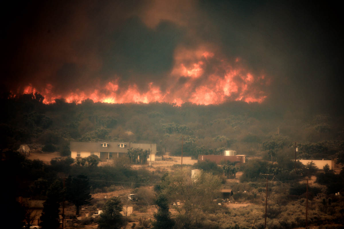
Blue Cut Fire. Photo by Jeff Zimmerman.

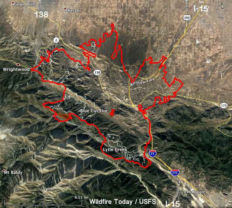
On Thursday the spread of the Blue Cut Fire north of San Bernardino in southern California was limited to the west side. According to the incident management team led by incident Commander Rocky Opliger, the growth added about 5,300 acres, bringing the total up to 39,000 acres.

The expansion occurred:

  • on the north side in the flats southeast of Phelan,
  • east of Wrightwood near Highway 2,
  • in the remote mountainous area on the west side, and
  • near Lytle Creek on the south side of the fire.

The east side of the fire has been relatively quiet for a couple of days.
Map Blue Cut Fire
Map of the Blue Cut Fire. The red line was the perimeter at 10:30 p.m. PDT August 18, 2016. The white line was the perimeter approximately 24 hours before.

A Red Flag Warning is in effect for the fire area Friday until 9 p.m. this evening for 15 to 25 mph southwest to west winds gusting to 35 mph during the afternoon and evening. Relative humidities will be 10 to 15 percent.

The fire started August 16 and grew to tens of thousands of acres quickly. Numerous structures were seen burning on live television, but no information has been released about how many were affected.

The incident management team expects the fire will continue to move to the north, northwest and northeast towards Wrightwood, Victor Valley, Phelan, Baldy Mesa and South Hesperia. Evacuations are still in place.

****

(UPDATED at 7:43 a.m. PDT August 18, 2016)
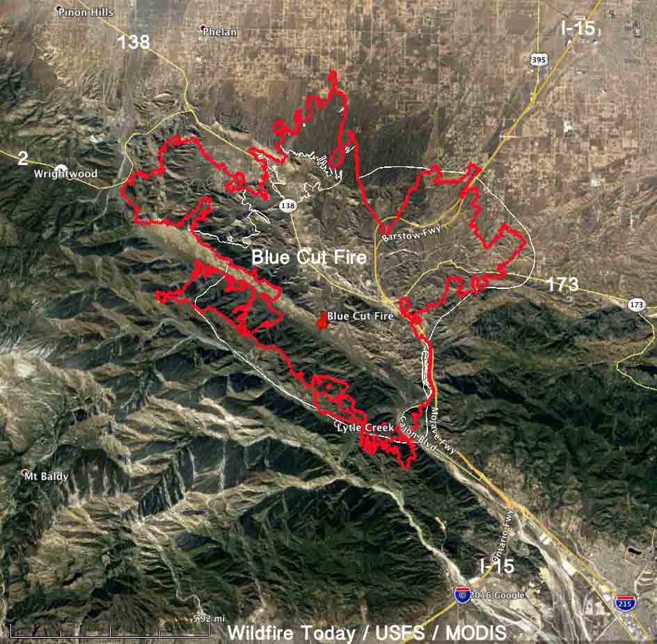
Map Blue Cut
Map of the Blue Cut Fire. The red line was the perimeter at 8 p.m. PDT August 17, 2016. The white line was the estimated perimeter approximately 24 hours before.

The Blue Cut Fire northwest of San Bernardino continued to spread Wednesday. The additional growth was on the northwest side where it reached Highway 2. And, on the north side it expanded a small amount at the base of the mountains and in the high desert flats toward Phelan. Evacuations are still in effect.

More accurate mapping on Wednesday resulted in the incident management team reducing the mapped size from 30,000 to 25,626 acres. After the growth of the fire yesterday, this morning they are calling it 31,689 acres.

Northbound Interstate 15 has reopened, but the southbound lanes are still closed. CALTRANS information about road conditions. UPDATE at 11:42 a.m. PDT August 18, 2016: Southbound I-15 is now open also.

Continue reading “Damage assessment teams report 96 homes destroyed in the Blue Cut Fire”

Researchers predict impacts of wildfire smoke after climate change

Above: Illustration from Harvard/Yale paper about the impacts of wildfire smoke following climate change. The colors indicate the number of smoke waves based on the primary smoke wave definition (cutoff= 6 μg/m3). The map on the left represents the present day (based on 2004-2009 data). The map on the right represents the future under climate change (based on projected data for the years 2046-2051). 

(Originally published at 11:39 a.m. MDT August 16, 2016; edited at 6 p.m. MDT August 17 to include this link to the research paper. We contacted the author and asked for a copy of the document, which we now have on our website for our readers.)

Researchers at Harvard and Yale Universities have written a paper predicting the quantities of wildfire smoke that will be impacting residents of the United States in the years 2046 through 2051. Unfortunately it will cost you $40 to get a copy of the complete results of their research. Open Access to publically funded research is apparently not a priority at Harvard and Yale. (UPDATE: on August 17 we obtained a copy of the paper from one of the authors. But it would still cost $40 to buy it from the journal.)

The information here is obtained from the abstract and one document with supplementary material that was available.

To identify the highest-risk areas, the team used a fire prediction model and advanced atmospheric modeling to separate pollution caused by wildfires from other pollution sources and track the likely movement of smoke. The authors estimate that under future climate change, more than 82 million individuals will experience a 57 percent and 31 percent increase in the frequency and intensity, respectively, of Smoke Waves, which they define as ≥2 consecutive days with high wildfire-specific PM2.5.

Northern California, Western Oregon and the Great Plains are likely to suffer the highest exposure to wildfire smoke in the future. Results point to the potential health impacts of increasing wildfire activity on large numbers of people in a warming climate and the need to establish or modify U.S. wildfire management and evacuation programs in high-risk regions. The study also adds to the growing literature arguing that extreme events in a changing climate could have significant consequences for human health.

A call to Loretta J. Mickley, one of the authors, to ask about access to the publically funded research, was not immediately returned. UPDATE, August 17, 2016: Ms. Mickley did call the following day, and said she was disappointed that Harvard chose a non-Open Access journal in which to place the paper. She said she will send us a copy of the paper and it will also be posted on her web site in the next day or two. We will link to it later. The research was funded, she said, by the Environmental Protection Agency and the National Institutes of Health. In our opinion government agencies that fund research should only do so if the findings are made public at no additional charge.

(UPDATE: we found the paper on Ms. Mickley’s web site and downloaded it.)

The paper’s authors are J.C. Liu, L.J. Mickley, M.P Sulprizio, et al.

Fire whirl on Beaver Creek Fire two months after the fire started

fire whirl beaver creek fire
Fire whirl on Division G of the Beaver Creek Fire August 15, 2016. Photo by Charles Bolt, Engine 1419.

Firefighter Charles Bolt took this impressive photo of a fire whirl on the Beaver Creek Fire. It was tweeted by the Medicine Bow-Routt National Forests and Thunder Basin National Grassland.

More information about fire whirls, fire tornados, fire devils, firenados, and fire storms.

Since the Beaver Creek Fire started on June 19, 2016 it has burned over 36,000 acres in northern Colorado and southern Wyoming. It is being managed by the Atlanta National Incident Management Organization (NIMO). The team described their strategy:

This is a full suppression fire utilizing both ground and aerial assets. Firefighters are engaging the fire out of the timber in areas which give them the highest probability for success. This suppression strategy provides for both firefighter safety and the protection of life and property.

After almost two months, the team claims 44 percent of the perimeter has been contained. They expect full containment on October 21 (the year was not specified). It sounds like they may be stretching the definition of “full suppression”. So far they have spent $20,600,000 of taxpayers’ money.

Here is another photo from the fire. Found on InciWeb, it is undated and uncredited.

Beaver Creek fire saved structure

Wildfire burns near two Olympic venues in Brazil

A wildfire burned close to several Olympic venues in Rio de Janeiro on Monday.

Below is an excerpt from an article in the Brisbane Times:

A forest fire on Monday placed the Olympic mountain biking venue in jeopardy, but games organisers insist the threat has passed.

Spectators arrived at the Olympic hockey centre late on Monday afternoon to find smoke and ash blowing over the venue ahead of the women’s quarter-final between Great Britain and Spain.

The conditions were a result of a fire which a Rio 2016 spokeswoman said started about 4pm near the Deodoro sports complex, home of the equestrian, rugby sevens, shooting, BMX, mountain biking, canoeing, kayaking, women’s basketball and modern pentathlon at these Games.

The spokeswoman said that the fire became more aggressive, placing the mountain bike centre in danger less than a week before it hosts the cross-country races of this year’s calendar.

But according to the spokeswoman, a change of wind direction moved the fire out of harm’s way. She said there had been no injuries as a result of the fire, with firefighters continuing in their attempts to extinguish it as of late on Monday night.

Another fire last week was near the rugby sevens venue.

Man arrested for starting the Clayton Fire and numerous others

(Originally published at 8:55 p.m. PDT August 15, 2016. Updated at 7:46 a.m. PDT August 16 with a list of charges against him and an updated mug shot.)

A man has been arrested for starting the Clayton Fire and numerous others.

Below is an excerpt from an article in The San Francisco Chronicle:

County officials arrested a 40-year-old Clear Lake man Monday on 17 counts of arson related to numerous fires set over the last year, including the 4,000-acre Clayton Fire that has so far claimed 175 buildings and displaced hundreds of people.

Damin Anthony Pashilk

Lake County Sheriff Brian Martin and Cal Fire Chief Ken Pimlott announced the arrest of Damin Pashilk at a community meeting packed with evacuees at a casino doubling as a Red Cross shelter south of the blaze. Residents gasped at the announcement.

Chief Pimlott said Mr. Pashilk had been under investigation for about a year. The charges were enhanced because homes and businesses were destroyed. He has been arrested at least a dozen times before mostly for parole violations, but also on drug and weapons charges.

He was arrested at 4:30 p.m. on August 15 and booked into jail at 12:58 am. August 16. For now he has been charged with:

  1. Arson: structure/forest land
  2. Arson sentence enhancement
  3. Aggravated arson with prior

The sentence enhancement is applicable if homes or businesses were destroyed.

Brian Hickey of KCRA News reports that “aggravated arson with prior” means he has been convicted of arson in the last 10 years.

Bail has been set at $5 million.

The Clayton Fire started Saturday evening and around mid-day on Sunday changed direction after the wind shifted and spread quickly into Lower Lake, California.

180-degree wind shift pushed Clayton Fire into Lower Lake

weather Clayton Fire
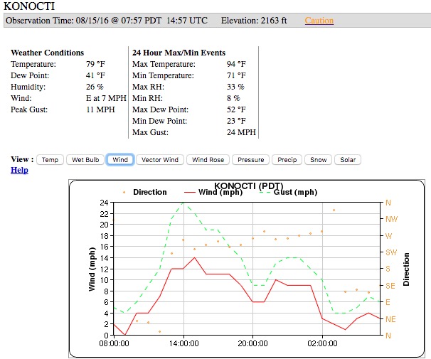
Weather observations at the Konocti weather station just west of Lower Lake, California, from about 8 a.m. on Sunday until 8 a.m. Monday.

The Clayton Fire that burned hundreds of structures in and near Lower Lake, California 31 air miles northeast of Santa Rosa, was rather benign Sunday morning, and some thought firefighters had a handle on it. But later in the day the wind increased and pushed it into the community, spreading much more quickly than firefighters expected or could keep up with.

We checked the weather conditions recorded at the Konocti weather station west of Lower Lake and found that the wind direction shifted by about 180 degrees at mid-day. Before noon there was a north to northeast wind at 0 to 6 mph blowing the fire away from Lower Lake. That changed very suddenly at around noon when the wind became out of the southwest and west at 12 to 14 mph with gusts of 19 to 24 mph. This pushed the fire into the community. The firefighters and other resources that were on hand were not able to keep up with the fire or protect every structure in the town.

At about the same time, the temperature went up to over 90 degrees and the relative humidity dropped from about 30 percent to around 18 percent, and may have briefly hit 8 percent.

Of all of the weather features that affect the behavior of a wildfire, a strong wind can override them all to a degree and control the direction of spread. Topography and fuels (vegetation) also help determine how a fire will spread, but if conditions are dry, wind is the ingredient that firefighters most respect.

Land managers and homeowners can control one of the three factors that determine fire behavior — fuel. It can be removed within 100 feet of structures. Large scale fuel reduction projects in the areas near communities can affect the intensity of a fire when it approaches structures, giving firefighters a chance to save them. But the other two factors, topography and weather, are out of their hands.

Weather forecast for the Clayton Fire area
Weather forecast for the Clayton Fire area, Aug 15, 2016. NWS. Click to enlarge.

The weather forecast for the area of the Clayton Fire predicts clear skies for Monday, a high of 97 degrees, 14 percent relative humidity, and southeast to east winds of 5 to 10 mph. Tuesday will be about the same but with very variable winds blowing from virtually all directions during the day.

Our main article about the Clayton Fire.