Above: Satellite photo taken August 2, 2017 showing smoke from some of the wildfires in British Columbia. The red dots represent heat detected by a sensor on the satellite
(Originally published at 9:50 p.m. MDT August 2, 2017)
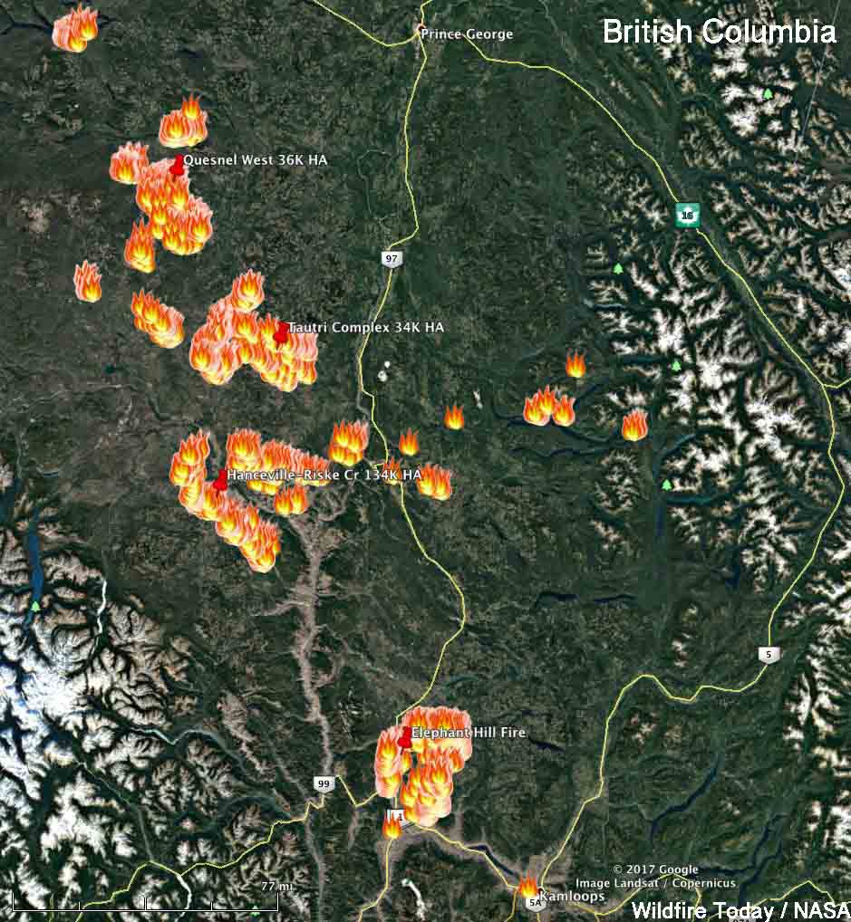
Firefighters in British Columbia are dealing with over 100 wildfires that are larger than 0.01 hectare. The location for four of the largest can be seen on the map below which shows heat detected by a satellite on Wednesday.

Here are very brief of summaries of four of the largest fires:
- Hanceville-Riske Creek, 60 kilometers southwest of Williams Lake. The Hanceville and the Riske Creek Fires are being managed as one. Together they have burned 134,000 hectares (331,000 acres).
- Quesnel West, 4 km north of the Baezaeko River. 36,000 HA (88,000 acres).
- Tautri Complex, 85 km northwest of Williams Lake. 64,000 HA (84,000 acres).
- Elephant Hill, near Ashcroft. 84,000 HA. (207,000 acres).
The weather forecast for Ashcroft near the Elephant Hill fire looks grim for firefighters — over 100F every day for the next week with the relative humidity around 20 percent or below. It looks better for Williams Lake with highs in the high 80’s and low 90’s with the relative humidity in the mid-20’s.


Definite prayers go out to the firefighters and to the people directly affected in the towns that were lost. I would hope that the US is also helping our neighbors with this disaster. Best wishes from Idaho
Yes, the residue of the Canadian fires is pretty bad, it resembles the way LA used to look on a bad smog day, However, at one time or another Washington, Oregon, and California have smoke from wildfires that circled the globe. Since much of western Canada is uninhabited, I would imagine most fires are from lightning. I know the firefighters in Canada and here are going through hell (I was in fire management for 19 years) and the most important thing we can pray for is that at the end of the day or incident everyone comes home.
Prayers to those in direct harm, and those fighting to contain it. Also to us down here in the greater northwest. This sucks. I’m ignorant of all this. Are they spontaneous natural events? 100 wildfires at the same time? Is it a sign that the smoke is cast so wide? If this many people are effected shouldn’t there be a bucket brigade from the greater northwest assisting to put this shxt out? It was the worst air quality in Portland I’ve seen in 26yrs. Talk about carbon emissions. It’s not looking good my friends.
Cough cough..cough cough…..we down here in the Lower 48 mainly Oregon and WA sure would be happy when these get under control eh???? Prayers to all you in the GWN……
Current WA wildfires, cough cough…not all Canada eh!
Bear Butte
Belknap
Bridge Creek
Chetco Bar
Diamond Creek
East Saddle
Falcon Complex
Ferry Canyon
Flounce
Head Water
High Cascades Complex
Hult Butte
Indian Creek
Jolly Mountain
Jones
Milli
Nena Springs
Noisy Creek
Norse Peak
Rebel
Shan Creek
Umpqua North Complex
Whitewater
Whychu
https://gacc.nifc.gov/nwcc/information/firemap.aspx
Just to be clear, The article and most of the comments were written almost 2 weeks ago.
This is great information! We really appreciate the aerial views because we are going through Hope, Kamloops, and on to Prince George in early September. At least we hope to! Too early to change plans now but growing more concerned. I spoke with the Gentleman at Big Country Campground and RV Park and he said that the road was blocked north and south of him. Thanks again and I made you a favorite.