Photo of the 747 Supertanker dropping on the Palmer Fire

(Originally published at 7:22 a.m. MDT September 5, 2017 on FireAviation.com)

A few days ago Cy Phenice sent us an excellent photo of Air Tanker 944, the 747 SuperTanker, dropping on the Palmer Fire south of Yucaipa, California which we published September 3. Now we have another great photo of the huge airplane dropping on the fire.

It was taken by Leroy Leggit with a Nikon D810. He shot it at 1/800, F 5.6, using a 70-200mm lens at 150mm.

He said he took the photo from the top of a hill looking down at the aircraft.
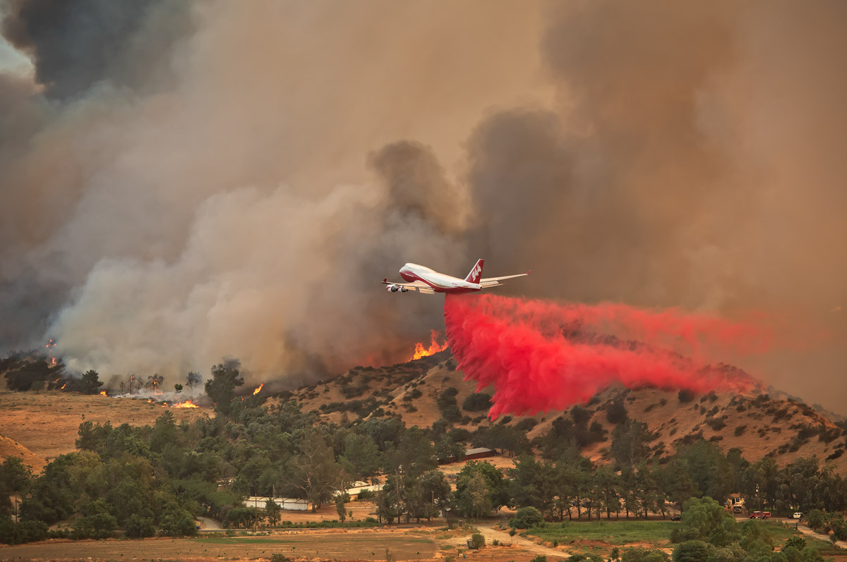
747 Palmer Fire
Air Tanker 944, a 747-400, drops near structures on the Palmer Fire south of Yucaipa, California at 4:25 p.m. PDT September 2, 2017. Photo by Leroy Leggitt, used with permission.

He told us:

I didn’t know anything about the 747 supertanker until it appeared to my right (at eye level) headed straight toward the fire… what an amazing and unexpected sight… I looked online and saw that it had only been in service for a few days.

The Palmer Fire was reported at 1:33 p.m. MDT September 2, 2017. It is nearly officially contained according to CAL FIRE after burning 3,874 acres.

This was the second fire the aircraft was used on after receiving certification and a contract from CAL FIRE. The 747 was dispatched from McClellan Air Field near Sacramento. According to FlightAware it cruised south at over 600 mph at times before dropping on the fire about an hour later, then reloaded at McClellan and completed a second sortie, dropping almost 19,000 gallons again, splitting the load into two drops.

Heavy smoke continues to spread across northwest and north-central US

Heavy smoke is being tracked in 12 states.

Above: Wildfire smoke map, 5:24 a.m. MDT September 4, 2017. The icons represent the locations of some of the large uncontained wildfires.

(Originally published at 10:50 a.m. MDT September 4, 2017)

The smoke from wildfires in Montana, Idaho, and the northwest United States is producing worsening conditions in the northwest and northcentral United States.

The locations that NOAA classified as having “heavy” smoke concentrations at 5:25 a.m. Monday included areas in California, Oregon, Washington, Idaho, Montana, North Dakota, South Dakota, Wyoming, Nebraska, Minnesota, Iowa and Kansas.

According to the National Interagency Coordination Center, there are 58 large uncontrolled fires, but that does not count the 29 fires being managed under a less than full suppression strategy. NICC says to date 7.6 million acres have burned, compared to the 10-year average of 5.4 million acres.

Rice Ridge Fire almost doubles in size to over 100,000 acres

At 10:45 p.m. Sunday it was mapped at 101,425 acres.

Above: The Rice Ridge Fire. Image uploaded to InciWeb September 3, 2017. Uncredited.

(Originally published at 10:11 a.m. MDT September 4, 2017)

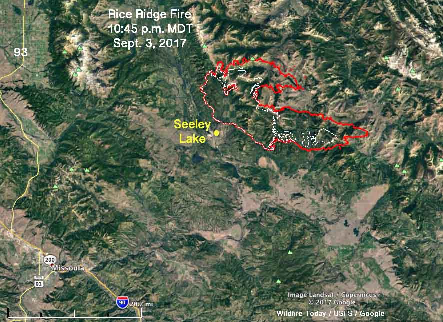
The Rice Ridge Fire just east of Seeley Lake, Montana, spread substantially Sunday, almost doubling in size. During a 10:45 mapping flight Sunday night, it was discovered that 48,531 acres had burned during the previous 24 hours bringing the total to 101,419 acres, achieving “megafire” status when it exceeded 100K acres. The blaze is 36 miles northeast of Missoula.

The west side of the fire near Seeley Lake did not change — the growth was on the north and east sides.

The key factors in the extreme fire behavior and spread on Sunday were the relative humidity and the wind. During the morning the wind was out of the south, which accounted for the growth on the north side. Then it slowly changed to be from the southwest and the west and by 9 p.m. was coming from the north.

Rice Ridge Fire map
The red line was the perimeter of the Rice Ridge Fire at 10:45 p.m. MDT September 3, 2017. The white line was the perimeter about 24 hours before. Click to enlarge.

The relative humidity just north of the community of Seeley Lake reached 8 percent Sunday, while the temperature maxed out at 88 degrees with 6 to 12 mph winds gusting at 14 to 18. The forecast for Monday calls for more moderate conditions — 78 degrees, east winds at 10-13, and 21 percent relative humidity.

Rice Ridge Fire Montana fire map missoula
The map shows heat detected on wildfires in the Missoula area at 10:45 p.m. MDT September 3, 2017. Click to enlarge.

The objective on the fire is not to put it out or contain it, but to herd it around as necessary to protect private property and structures. On Sunday 737 personnel were assigned to the fire which so far has run up costs of almost $30 million.

Dozens of wildfires very active in Montana and Idaho

Above: Wildfires in Montana and Idaho September 3, 2017. The map shows heat detected by a satellite during the 24-hour period ending at 10 p.m. MDT September 3, 2017.

(Originally published at 5:47 a.m. MDT September 4, 2017.)

Residents in eastern Montana and northern Idaho have been living with wildfires that are nearby for a couple of months and the situation continues today. Dozens of large fires are still eating up the acreage and creating heavy smoke and sometimes “unhealthy” air quality according to the monitoring services of the EPA and other organizations.

Wildfire smoke affects northwestern and central United States

In Rapid City, South Dakota the visibility Sunday afternoon was 2.5 miles, and was even less in Hot Springs.

Above: The map shows the distribution of smoke from wildfires. The smoke from wildfires in Montana, Idaho, Washington, Oregon, and California is being distributed widely across the country.

(Originally published at 9:35 p.m. MDT September 3, 2017.)

After having been on the road for a week and a half I flew in to Rapid City late Sunday afternoon. As we began to descend to the airport the pilot came on the PA system to give their typical information about the last leg of the flight and the weather conditions in the destination city. He said smoke was reducing the visibility to 2.5 miles at Rapid and guessed that it was due to fires in the Black Hills.

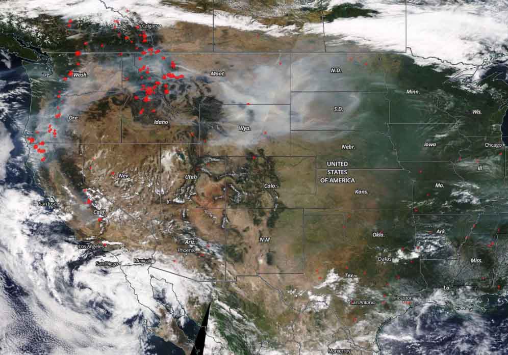
But it was actually coming from much farther away —  most of it probably from Montana and Idaho, but Oregon, Washington, and California are also producing large quantities of the stuff.

satellite photo smoke fires
Satellite photo showing smoke created by wildfires September 3, 2017. The red dots represent heat detected by the satellite at 3:04 p.m. MDT September 3, 2017.

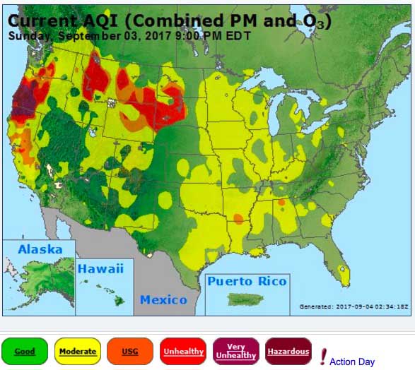
The AirNow map below shows large sections of several states with “unhealthy” air quality: South Dakota, North Dakota, Montana, Idaho, Wyoming, Washington, Oregon, and California. Oregon and California have the distinction of “very unhealthy” air in some areas.


smoke wildfires map
AirNow map showing air quality at 8:34 p.m. MDT September 3, 2017.